


MapSherpa Catalog
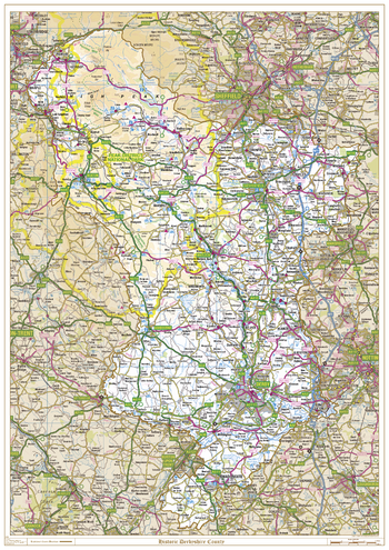
Historic Derbyshire County Map
XYZ Maps
This is a historic county map of Derbyshire, highlighting the traditional county border, the surrounding area is faded out with a sepia tint for excellent contrast. The historic map covers, Glossop, Buxton, Chesterfield, Matlock, Ashbourne, Derby, and Swadlincote. The traditional county map has the historic county boundaries overlaid on an up to date Ordnance Survey 1:250,000 scale map.
Page Size: 33.25 x 47 in (841 x 1189 mm)
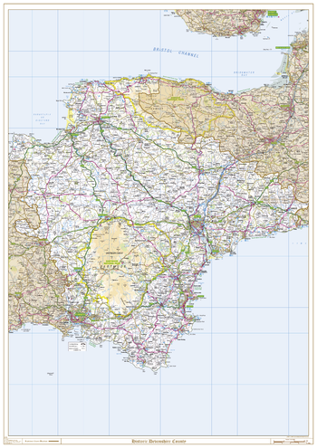
Historic Devonshire County Map
XYZ Maps
This is a historic county map of Devonshire, highlighting the traditional county border, the surrounding area is faded out with a sepia tint for excellent contrast. The historic map covers, Axminster, Barnstaple, Bideford, Dartmouth, Exeter, Exmouth, Ilfracombe, Newton Abbot, Plymouth, Sidmouth, Torquay, Paignton, Tiverton, Newton Abbot and Tavistock. The traditional county map has the historic county boundaries overlaid on an up to date Ordnance Survey 1:250,000 scale map.
Page Size: 33.25 x 47 in (841 x 1189 mm)
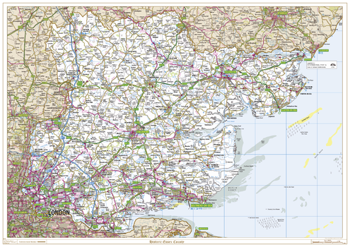
Historic Essex County Map
XYZ Maps
This is a historic county map of Essex, highlighting the traditional county border, the surrounding area is faded out with a sepia tint for excellent contrast. The historic map covers, Saffron Walden, Halstead, Braintree, Stanstead Mountfitchet, Colchester, Harwich, Clacton-on-Sea, Chelmsford, Harlow, Stratford, Dagenham, Tilbury, Basildon, and Southend-on-Sea. The traditional county map has the historic county boundaries overlaid on an up to date Ordnance Survey 1:250,000 scale map.
Page Size: 47 x 33.25 in (1189 x 841 mm)
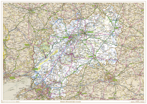
Historic Gloucestershire County Map
XYZ Maps
This is a historic county map of Gloucestershire, highlighting the traditional county border, the surrounding area is faded out with a sepia tint for excellent contrast. The historic map covers, Bristol, Cheltenham, Chipping Campden, Cirencester, Lydney, Nailsworth, Stow-on-the-Wold, Stroud and Tewkesbury. The traditional county map has the historic county boundaries overlaid on an up to date Ordnance Survey 1:250,000 scale map.
Page Size: 47 x 33.25 in (1189 x 841 mm)
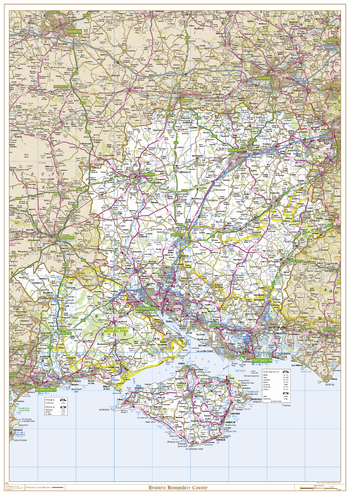
Historic Hampshire County Map
XYZ Maps
This is a historic county map of Hampshire, highlighting the traditional county border, the surrounding area is faded out with a sepia tint for excellent contrast. The historic map covers, Aldershot, Basingstoke, Bournemouth, Christchurch, Cowes, Newport, Petersfield, Portsmouth, Ringwood, Ryde, Southampton, Winchester and Ventnor. The traditional county map has the historic county boundaries overlaid on an up to date Ordnance Survey 1:250,000 scale map.
Page Size: 33.25 x 47 in (841 x 1189 mm)
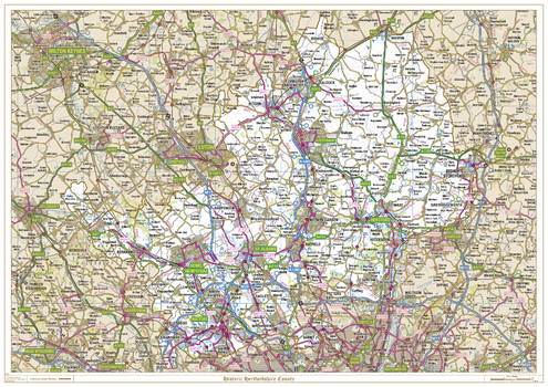
Historic Hertfordshire County Map
XYZ Maps
This is a historic county map of Hertfordshire, highlighting the traditional county border, the surrounding area is faded out with a sepia tint for excellent contrast. The historic map covers, Royston, Letchworth Garden City, Bishops Stortford, Welwyn Garden City, Borehamwood, Hatfield, Hemel Hempstead, Hitchin, Hertford, St Albans, Tring, Watford and Rickmansworth. The traditional county map has the historic county boundaries overlaid on an up to date Ordnance Survey 1:250,000 scale map.
Page Size: 47 x 33.25 in (1189 x 841 mm)
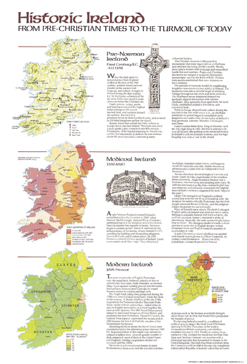
Historic Ireland Theme - Published 1981
National Geographic
This educational map of Historic Ireland was published in April 1981 with three articles on Ireland and an additional map entitled "Ireland and Northern Ireland: A Visitor's Guide." These maps provide a wonderful overview of the island's tumultuous and colorful history.
Page Size: 14 x 20.5 in (353 x 520 mm)
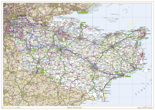
Historic Kent County Map
XYZ Maps
This is a historic county map of Kent, highlighting the traditional county border, the surrounding area is faded out with a sepia tint for excellent contrast. The historic map covers, Abbots Bromley, Canterbury, Chatham, Dover, Folkestone, Greenwich, Lewisham, Maidstone, Orpington, Ramsgate, Rochester, Sevenoaks, Tunbridge Wells, Whitstable, and Woolwich. The traditional county map has the historic county boundaries overlaid on an up to date Ordnance Survey 1:250,000 scale map.
Page Size: 47 x 33.25 in (1189 x 841 mm)
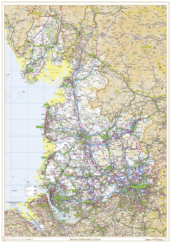
Historic Lancashire County Map
XYZ Maps
This is a historic county map of Lancashire, highlighting the traditional county border, the surrounding area is faded out with a sepia tint for excellent contrast. The historic map covers, Morecombe, Lancaster, Fleetwood, Blackpool, Skelmersdale, Preston, Blackburn, Burnley and Clitheroe. The traditional county map has the historic county boundaries overlaid on an up to date Ordnance Survey 1:250,000 scale map.
Page Size: 33.25 x 47 in (841 x 1189 mm)
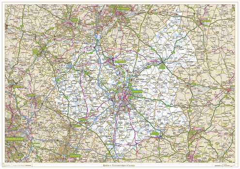
Historic Leicestershire County Map
XYZ Maps
This is a historic county map of Leicestershire, highlighting the traditional county border, the surrounding area is faded out with a sepia tint for excellent contrast. The historic map covers, Ashby-de-La-Zouch, Coalville, Hinckley, Leicester, Loughborough, Lutterworth, Market Bosworth, Market Harborough and Melton Mowbray. The traditional county map has the historic county boundaries overlaid on an up to date Ordnance Survey 1:250,000 scale map.
Page Size: 47 x 33.25 in (1189 x 841 mm)
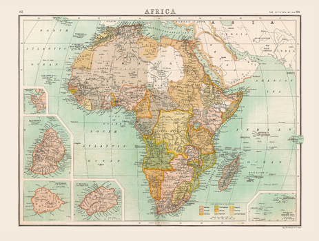
Historic Map of Africa (1898)
Collins
Full colour historical map of Africa from The Citizen's Atlas, published by John Bartholomew and Co. Ltd. in 1898. This map of Africa shows the continent at the height of the colonial era, when native rule by the indigenous population had been all but wiped out. Only Liberia on the west coast and Abyssinia (now Ethiopia) in the east were free from European control. The situation was caused by the Scramble for Africa in the late nineteenth century. For clarity, an additional key explains which territory is under the control of the many competing empires in the region. Additional inset maps provide extra details about the islands of Sierra Leone, Mauritius, Ascension, St. Helena, and the Seychelle and Amirante Isles. This map is part of a fascinating collection from the last 150 years of world atlases.
Page Size: 16.25 x 12.5 in (413 x 312 mm)
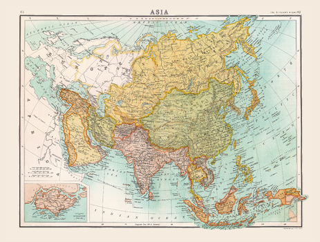
Historic Map of Asia (1898)
Collins
Full colour historical map of Asia from The Citizen's Atlas, published by John Bartholomew and Co. Ltd. in 1898. Dominated by Russia and China, this historical map shows Asia in the midst of change as Empires rose and fell, and territories exchanged hands. International borders are clearly marked, and individual countries are rendered in alternate colours for clarity. Oceans, rivers, mountain ranges and shipping routes are also visible and labelled. An additional inset map provides further details of the Island of Singapore. This map is part of a fascinating collection from the last 150 years of world atlases.
Page Size: 16.5 x 12.5 in (413 x 312 mm)
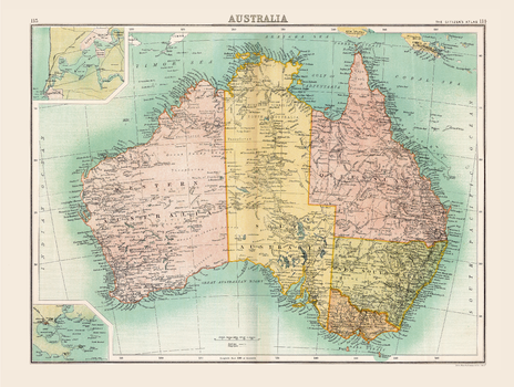
Historic Map of Australia (1898)
Collins
Full colour historical map of Australia from The Citizen's Atlas, published by John Bartholomew and Co. Ltd. in 1898. This map records the geopolitical make-up of Australia immediately prior to the ending of British colonial rule. The political boundaries depicted here had been established during the course of the nineteenth century, and with minor exceptions have remained unchanged to the present day. Additional inset maps provide a more detailed look at the City of Perth and King George Sound. This map is part of a fascinating collection from the last 150 years of world atlases.
Page Size: 16.5 x 12.5 in (413 x 312 mm)
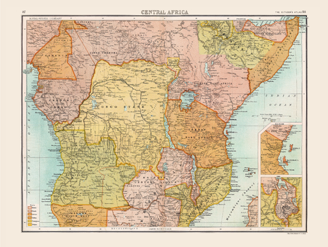
Historic Map of Central Africa (1898)
Collins
Full colour historical map of Central Africa from The Citizen's Atlas, published by John Bartholomew and Co. Ltd. in 1898. This map of Africa shows the continent at the height of the colonial era, only Liberia on the west coast and Abyssinia (now Ethiopia) in the east were free from European control. The situation reflects the result of the Scramble for Africa which occurred in the late nineteenth century. Britain, France and Germany were the dominant players in this partitioning, but the map’s key shows that other nations were also involved. Additional inset maps provide further details about the Shire Highlands, and the islands of Zanzibar and Pemba. This map is part of a fascinating collection from the last 150 years of world atlases.
Page Size: 16.5 x 12.5 in (413 x 312 mm)
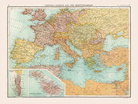
Historic Map of Central Europe and The Mediterranean (1898)
Collins
Full colour historical map of Central Europe and the Mediterranean from The Citizen's Atlas, published by John Bartholomew and Co. Ltd. in 1898. A pre-World War One map, the international borders shown here would not last for very long. Changes are especially visible when comparing regions such as Austro-Hungary, the German Empire and Russian Empire with maps of today. Borders are clearly marked, and individual countries are rendered in alternate colours for clarity. Oceans, rivers, mountain ranges and shipping routes are also visible and labelled. Two additional maps of Gibraltar and the Maltese Islands provide further information about these regions. This map is part of a fascinating collection from the last 150 years of world atlases.
Page Size: 16.25 x 12.5 in (412 x 312 mm)
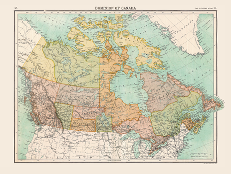
Historic Map of Dominion of Canada (1898)
Collins
Full colour historical map of the Dominion of Canada from The Citizen's Atlas, published by John Bartholomew and Co. Ltd. in 1898. The map provides a snapshot of Canada after the British colonies of North America were granted autonomy under the Crown in 1867, in this case as the Dominion of Canada. Many of the territorial names on this map are recognizable today while others, including Assiniboia and Athabasca, are less familiar. This map is part of a fascinating collection from the last 150 years of world atlases.
Page Size: 16.25 x 12.5 in (413 x 312 mm)
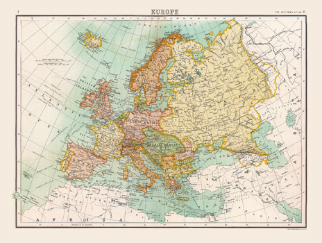
Historic Map of Europe (1898)
Collins
Full colour historical map of Europe from The Citizen's Atlas, published by John Bartholomew and Co. Ltd. in 1898. A pre-World War One map, the international borders shown here would not last for very long. Changes are especially visible when comparing regions such as Austro-Hungary, the German Empire and Russian Empire on this map with maps of today. Borders are clearly marked, and individual countries are rendered in alternate colours for clarity. Oceans, rivers, mountain ranges and shipping routes are also visible and labelled. This map is part of a fascinating collection from the last 150 years of world atlases.
Page Size: 16.5 x 12.5 in (413 x 312 mm)
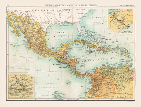
Historic Map of Mexico, Central America & West Indies (1898)
Collins
Full colour historical map of Mexico, Central America and the West Indies from The Citizen's Atlas, published by John Bartholomew and Co. Ltd. in 1898. The Central America of today is very similar to the one depicted in this map with two small exceptions: British Honduras became the independent Belize in 1981, and the absence of Panama which became part of Colombia in 1830. The Caribbean, however, has changed more significantly as colonial powers came and went. Additional inset maps show Mexico City and the abandoned attempt to build the Panama Canal in 1880. This map is part of a fascinating collection from the last 150 years of world atlases.
Page Size: 16.25 x 12.5 in (413 x 312 mm)
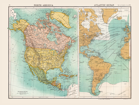
Historic Map of North America and Atlantic Ocean (1898)
Collins
Full colour historical map of North America and the Atlantic Ocean from The Citizen's Atlas, published by John Bartholomew and Co. Ltd. in 1898. Divided into two maps, the North America map on the left shows the forty-five states that made up America at the time, as well as Greenland, Mexico, Central America, and the British-owned Dominion of Canada. The right map shows the Atlantic Ocean, with specific focus on the international trade routes across it. This map is part of a fascinating collection from the last 150 years of world atlases.
Page Size: 16.5 x 12.5 in (413 x 312 mm)
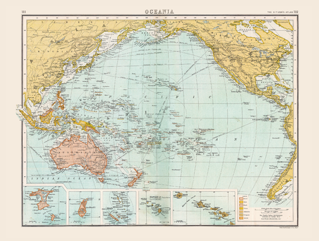
Historic Map of Oceania (1898)
Collins
Full colour historical map of Oceania from The Citizen's Atlas, published by John Bartholomew and Co. Ltd. in 1898. Dominated by shifting colonial powers, Oceania at the time was a complex region to map; this is clearly seen with New Guinea, an island shared between Britain, Germany and the Netherlands. For clarity, an additional key explains which territory is under the control of the many competing empires in the region. Further inset maps provide a more detailed look at Chatham Island, Pitt Island, Auckland Island, the New Hebrides, and Hawaii and the surrounding islands. A main feature of this map is the extensive trade routes that traversed the region. This map is part of a fascinating collection from the last 150 years of world atlases.
Page Size: 16.25 x 12.5 in (413 x 312 mm)
No search results