


MapSherpa Catalog
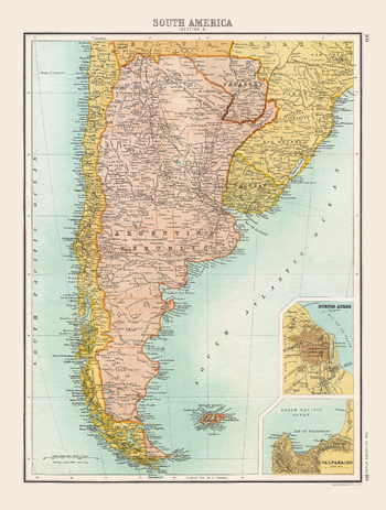
Historic Map of South America (1898)
Collins
Full colour historical map of South America from The Citizen's Atlas, published by John Bartholomew and Co. Ltd. in 1898. The map of South America in 1898 depicts a continent whose borders are mostly recognizable today. The decolonization process through the nineteenth century had seen the Spanish and Portuguese lose their New World mainland territories and newly independent countries take their place. A territorial dispute which still continues today is that of Argentina’s claim over the Falkland Islands (known in Argentina as the Islas Malvinas) in the South Atlantic Ocean. Additional inset maps provide a more detailed look at Buenos Ayres and Valparaiso. This map is part of a fascinating collection from the last 150 years of world atlases.
Page Size: 12.5 x 16.25 in (312 x 413 mm)
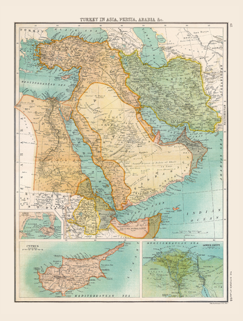
Historic Map of Turkey in Asia, Persia, Arabia &c. (1898)
Collins
Full colour historical map of Turkey in Asia, Persia, Arabia, &c. from The Citizen's Atlas, published by John Bartholomew and Co. Ltd. in 1898. Dominated by Empires, this map shows the reach of the Ottoman Empire into Asia at this time, as well as the recent British acquisition of Egypt and the valued trade route to British India via the Suez Canal. Additional inset maps provide further information about Aden, Cyprus and Lower Egypt. This map is part of a fascinating collection from the last 150 years of world atlases.
Page Size: 12.5 x 16.25 in (312 x 412 mm)
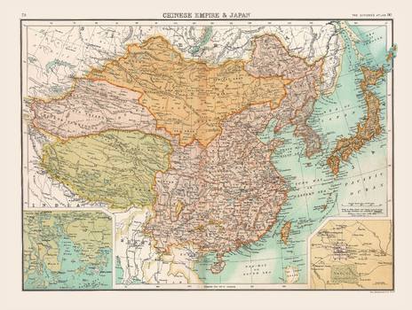
Historic Map of the Chinese Empire and Japan (1898)
Collins
Full colour historical map of the Chinese Empire and Japan from The Citizen's Atlas, published by John Bartholomew and Co. Ltd. in 1898. In addition to showing the Chinese Empire and Japan, this map also shows Tibet, Chinese Turkistan, Korea, and Mongolia in full, with clear borders between the countries and territories. Additional inset maps provide a more detailed look at Peking, restyled now as Beijing, China’s Capital city, and Chu Kiang (the Canton River). This map is part of a fascinating collection from the last 150 years of world atlases.
Page Size: 16.5 x 12.5 in (413 x 312 mm)
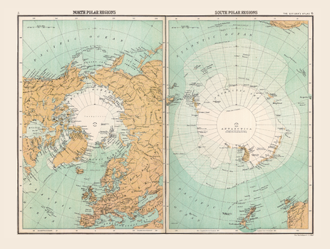
Historic Map of the Polar Regions (1898)
Collins
Full colour historical map of the polar regions from The Citizen's Atlas, published by John Bartholomew and Co. Ltd. in 1898. Divided into two sections: one displaying the North polar regions and the other the South, this map demonstrates what was known about these areas in 1898 when polar exploration was only just beginning in earnest. While large middle sections of the regions are marked as Unexplored, what was explored is detailed and shown in relation to surrounding countries. This map is part of a fascinating collection from the last 150 years of world atlases.
Page Size: 16.25 x 12.5 in (412 x 312 mm)
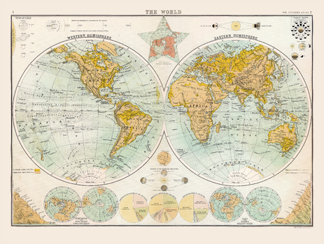
Historic Map of the World (1898)
Collins
Full colour historical map of the world from The Citizen's Atlas, published by John Bartholomew and Co. Ltd. in 1898. Divided into two circles showing the Western and Eastern Hemispheres, this historical map clearly shows continental and country borders, allowing for a clear view of the world, as it was viewed at the time. Extra information including astronomical diagrams, graphical representations of the world’s highest mountains and statistical charts of population is placed beside the map to allow for a complete understanding of how the world was seen at the end of the nineteenth century. This map is part of a fascinating collection from the last 150 years of world atlases.
Page Size: 16.25 x 12.5 in (413 x 312 mm)
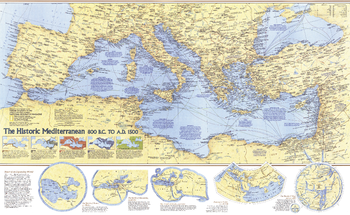
Historic Mediterranean, 800 BC to AD 1500 - Published 1982
National Geographic
The Mediterranean region was home to many of the greatest civilizations in human history, including the ancient Greeks and Romans. This map contains a wealth of information about the history of the civilizations who inhabited the region from 800 BC to AD 1500, and the archeaological sites they left behind. Published in December 1982 as a companion to the outstanding "Mediterranean Seafloor" map and three articles on the Mediterranean Sea.
Page Size: 37 x 22.75 in (934 x 573 mm)
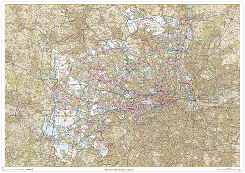
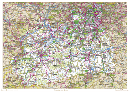
Historic Middlesex County Map
XYZ Maps
This is a historic county map of Middlesex, highlighting the traditional county border, the surrounding area is faded out with a sepia tint for excellent contrast. The historic map covers, Potters Bar, Enfield, Southgate, Edmonton, Tottenham, Wood Green, Friern Barnet, Hornsey, Finchley, Hendon, Harrow, Ruislip-Northwood, Uxbridge, Ealing, Wembley, Willesden, Acton, Brentford and Chiswick, Heston and Isleworth, Southall, Hayes and Harlington, Yiewsley and West Drayton, Staines, Feltham, Twickenham, and Sunbury-on-Thames. The traditional county map has the historic county boundaries overlaid on an up to date Ordnance Survey 1:50,000 scale map.
Page Size: 47 x 33.25 in (1189 x 841 mm)
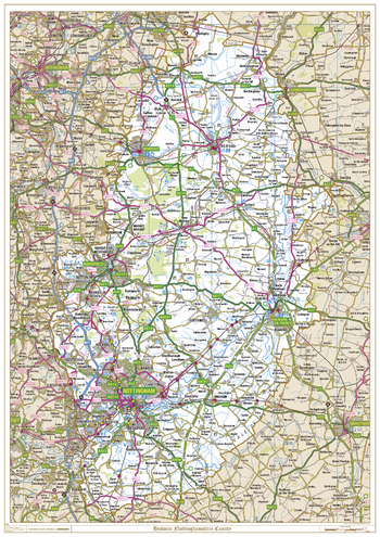
Historic Nottinghamshire County Map
XYZ Maps
This is a historic county map of Nottinghamshire, highlighting the traditional county border, the surrounding area is faded out with a sepia tint for excellent contrast. The historic map covers, Nottingham, Newark on Trent, Mansfield, Worksop and Retford. The traditional county map has the historic county boundaries overlaid on an up to date Ordnance Survey 1:250,000 scale map.
Page Size: 33.25 x 47 in (841 x 1189 mm)
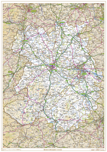
Historic Shropshire County Map
XYZ Maps
This is a historic county map of Shropshire, highlighting the traditional county border, the surrounding area is faded out with a sepia tint for excellent contrast. The historic map covers, Whitchurch, Oswestry, Newport, Shrewsbury, Telford, Bridgnorth, Church Stretton, Bishops Castle, and Ludlow. The traditional county map has the historic county boundaries overlaid on an up to date Ordnance Survey 1:250,000 scale map.
Page Size: 33.25 x 47 in (841 x 1189 mm)
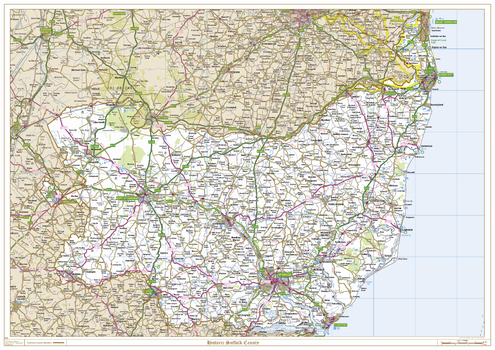
Historic Suffolk County Map
XYZ Maps
This is a historic county map of Suffolk, highlighting the traditional county border, the surrounding area is faded out with a sepia tint for excellent contrast. The historic map covers, Lowestoft, Beccles, Bury St Edmunds, Stowmarket, Sudbury, Ipswich and Felixstowe. The traditional county map has the historic county boundaries overlaid on an up to date Ordnance Survey 1:250,000 scale map.
Page Size: 47 x 33.25 in (1189 x 841 mm)
Historic Surrey County Map
XYZ Maps
This is a historic county map of Surrey, highlighting the traditional county border, the surrounding area is faded out with a sepia tint for excellent contrast. The historic map covers, Battersea, Brixton, Clapham, Croydon, Epsom, Farnham, Gatwick, Guildford, Haselmere, Kington-upon-Thames, Leatherhead, Richmond, Southwark, Wandsworth, Wimbledon and Woking. The traditional county map has the historic county boundaries overlaid on an up to date Ordnance Survey 1:250,000 scale map.
Page Size: 47 x 33.25 in (1189 x 841 mm)
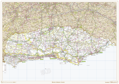
Historic Sussex County Map
XYZ Maps
This is a historic county map of Sussex, highlighting the traditional county border, the surrounding area is faded out with a sepia tint for excellent contrast. The historic map covers, East Grinstead, Crawley, Horsham, Midhurst, Chichester, Bognor Regis, Worthing, Crowborough, Uckfield, Heathfield, Hailsham, Lewes, Brighton and Hove, Newhaven, Eastbourne, Hastings, and Rye. The traditional county map has the historic county boundaries overlaid on an up to date Ordnance Survey 1:250,000 scale map.
Page Size: 47 x 33.25 in (1189 x 841 mm)
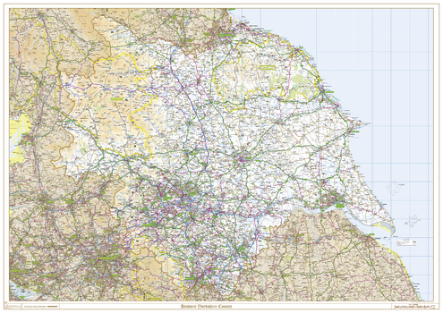
Historic Yorkshire County Map
XYZ Maps
This is a historic county map of Yorkshire, highlighting the traditional county border, the surrounding area is faded out with a sepia tint for excellent contrast. The historic map covers, Middlesbrough, Whitby, Scarborough, Bridlington, Skipton, Harrogate, York, Kingston Upon Hull, Leeds, Bradford, Huddersfield, Barnsley, Doncaster, Rotherham and Sheffield. The traditional county map has the historic county boundaries overlaid on an up to date Ordnance Survey 1:250,000 scale map.
Page Size: 47 x 33.25 in (1189 x 841 mm)
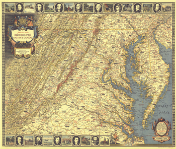
Historic and Scenic Reaches of the Nations Capital - Published 1938
National Geographic
With its border of notable figures and places, this map of the Historic and Scenic Reaches of the Nation's Capital is as much a work of art as a map. Published in July 1938 with the article "Roads from Washington," it contains a variety of interesting historical sites and notes. A unique cartographic work and perfect for framing.
Page Size: 30.75 x 26.25 in (781 x 661 mm)
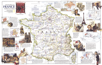
Historical France - Published 1989
National Geographic
National Geographic celebrated the bicentennial of the French Revolution in July 1989 by devoting the entire issue to France. This wonderful map contains a wealth of information about the history of France, historical sites, and popular resorts and tourist activities. It appeared as a companion to the "France" political map of the country.
Page Size: 31.5 x 20.5 in (799 x 515 mm)
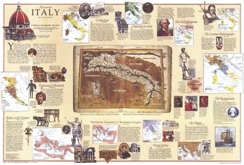
Historical Italy Theme - Published 1995
National Geographic
Half of a two-map set, this historical map of Italy appeared in the February 1995 issue of National Geographic with a stunning physical and political map of the country and an article on Venice. Filled with historical information and illustrations, this map boasts eleven inset maps detailing key periods.
Page Size: 33 x 22.25 in (834 x 563 mm)
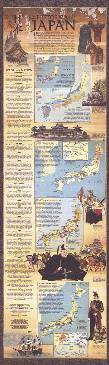
Historical Japan - Published 1984
National Geographic
The companion to the Japan map of 1984 and the article "Hagi: Where Japan's Revolution Began," this stunning work contains six maps detailing periods of history from the Stone Age through modern Japan. The elegant illustrations, abundant text and historical timeline make this a must-have for anyone interested in Japanese history.
Page Size: 11.25 x 37.25 in (283 x 941 mm)
Historical London
A-Z Maps
This historical mapping of central London is made up from extracts of hand drawn pen and ink street map originals. This mapping, which includes bus, trolleybus and tram routes, shows the streets of London as they were just before the Second World War.
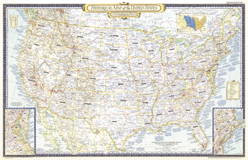
Historical Map of the United States - Published 1953
National Geographic
The Historical Map of the United States published in June 1953 accompanied six articles on the United States including "Founders of New England." A unique collectible, this map of the continental United States features a wealth of historical information, subtle relief shading, and details such as explorers' routes and immigrant trails.
Page Size: 41 x 26.5 in (1038 x 671 mm)
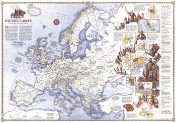
History of Europe, the Major Turning Points - Published 1983
National Geographic
Travel through time with this map as it explores the major turning points in European history. Features dazzling illustrations and multiple inset maps. Published in December 1983 as a companion to the "Europe" map and four articles including "Rome of the East."
Page Size: 43.25 x 30.5 in (1098 x 770 mm)
No search results