XYZ Maps
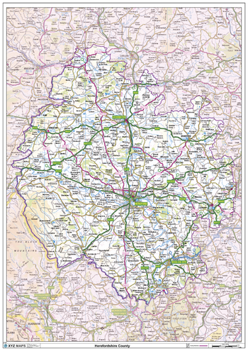
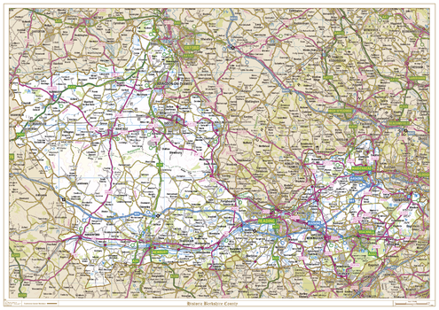
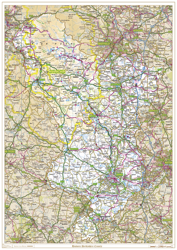
Herefordshire County Map
This is a large ceremonial county map of Herefordshire highlighting the county border, with the surrounding area faded out for excellent contrast. The map covers Bromyard, Goodrich, Kington, Ledbury, Leominster, Hereford, Ross-on-Wye and Weobley.The county map shows the latest County and Unitary Authority Boundaries, Overlaid on a Clear and Easy to Read Ordnance Survey map.
Page Size: 33.25 x 47 in (841 x 1189 mm)
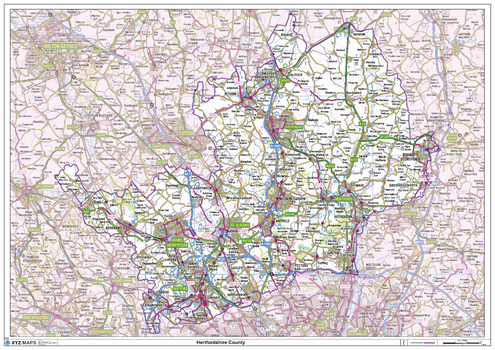
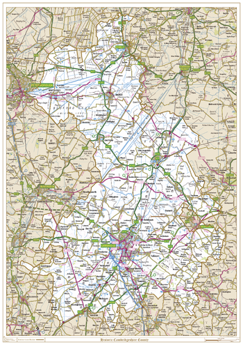
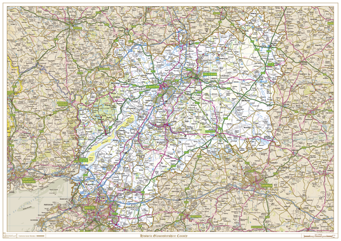
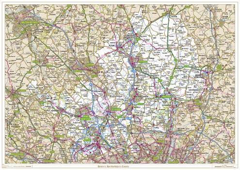
Hertfordshire County Map
This is a large ceremonial county map of Hertfordshire highlighting the county border, with the surrounding area faded out for excellent contrast. The map covers Royston Letchworth Garden City, Bishops Stortford, Welwyn Garden City, Borehamwood, Hatfield, Hemel Hempstead, Hitchin, Hertford, St Albans, Tring, Watford and Rickmansworth. The county map shows the latest County and Unitary Authority Boundaries, Overlaid on a Clear and Easy to Read Ordnance Survey map.
Page Size: 47 x 33.25 in (1189 x 841 mm)
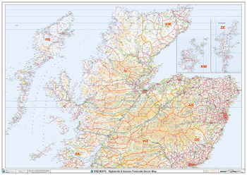
Highlands & Islands Postcode Sector Wall Map (S19)
The Highlands & Islands Postcode Sector Wall Map shows detailed postcode sector boundaries along with its associated label (IV1 1, IV1 2) on a comprehensive background and is perfect for determining postcode boundaries, for sales, logistics, planning mailshots or as a regional reference guide.
Page Size: 47 x 33.25 in (1189 x 841 mm)
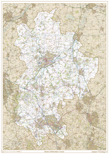
Historic Bedfordshire County Map
This is a historic county map of Bedfordshire, highlighting the traditional county border, the surrounding area is faded out with a sepia tint for excellent contrast. The historic map covers, Eaton Socon, Bedford, Sharnbrook, Harold, Ampthill, Flitwick, Barton-le-Clay, Leighton Buzzard, Dunstable, and Luton. The traditional county map has the historic county boundaries overlaid on an up to date Ordnance Survey 1:50,000 scale map.
Page Size: 33.25 x 47 in (841 x 1189 mm)
Historic Berkshire County Map
This is a historic county map of Berkshire, highlighting the traditional county border, the surrounding area is faded out with a sepia tint for excellent contrast. The historic map covers Abington-on-Thames, Didcot, Wantage, Shrivenham, Hungerford, Newbury, Reading, Wokingham, Maidenhead, Windsor, and Bracknell. The traditional county map has the historic county boundaries overlaid on an up to date Ordnance Survey 1:250,000 scale map.
Page Size: 47 x 33.25 in (1189 x 841 mm)
Historic Cambridgeshire County Map
This is a historic county map of Cambridgeshire, highlighting the traditional county border, the surrounding area is faded out with a sepia tint for excellent contrast. The historic map covers Wisbech, Whittlesey, Chatteris, March, Ely, and Cambridge. The traditional county map has the historic county boundaries overlaid on an up to date Ordnance Survey 1:250,000 scale map.
Page Size: 33.25 x 47 in (841 x 1189 mm)
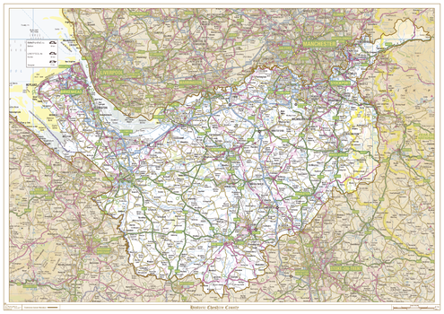
Historic Cheshire County Map
This is a historic county map of Cheshire, highlighting the traditional county border, the surrounding area is faded out with a sepia tint for excellent contrast. The historic map covers Stockport, Altringham, Runcorn, Ellesmere Port, Birkenhead, Northwich, Chester, Congleton, Macclesfield, and Nantwich. The traditional county map has the historic county boundaries overlaid on an up to date Ordnance Survey 1:250,000 scale map.
Page Size: 47 x 33.25 in (1189 x 841 mm)
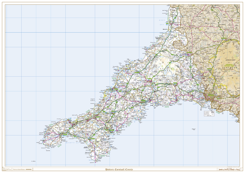
Historic Cornwall County Map
This is a historic county map of Cornwall, highlighting the traditional county border, the surrounding area is faded out with a sepia tint for excellent contrast. The historic map covers, Bodmin, Bude, Falmouth, Fowey, Launceston, Lostwithiel, Mousehole, Padstow, Penzance, Redruth, St Austell, St Ives, Truro, St Neots, Saltash, and Tintagel. The traditional county map has the historic county boundaries overlaid on an up to date Ordnance Survey 1:250,000 scale map.
Page Size: 47 x 33.25 in (1189 x 841 mm)
Historic Derbyshire County Map
This is a historic county map of Derbyshire, highlighting the traditional county border, the surrounding area is faded out with a sepia tint for excellent contrast. The historic map covers, Glossop, Buxton, Chesterfield, Matlock, Ashbourne, Derby, and Swadlincote. The traditional county map has the historic county boundaries overlaid on an up to date Ordnance Survey 1:250,000 scale map.
Page Size: 33.25 x 47 in (841 x 1189 mm)
Historic Devonshire County Map
This is a historic county map of Devonshire, highlighting the traditional county border, the surrounding area is faded out with a sepia tint for excellent contrast. The historic map covers, Axminster, Barnstaple, Bideford, Dartmouth, Exeter, Exmouth, Ilfracombe, Newton Abbot, Plymouth, Sidmouth, Torquay, Paignton, Tiverton, Newton Abbot and Tavistock. The traditional county map has the historic county boundaries overlaid on an up to date Ordnance Survey 1:250,000 scale map.
Page Size: 33.25 x 47 in (841 x 1189 mm)
Historic Essex County Map
This is a historic county map of Essex, highlighting the traditional county border, the surrounding area is faded out with a sepia tint for excellent contrast. The historic map covers, Saffron Walden, Halstead, Braintree, Stanstead Mountfitchet, Colchester, Harwich, Clacton-on-Sea, Chelmsford, Harlow, Stratford, Dagenham, Tilbury, Basildon, and Southend-on-Sea. The traditional county map has the historic county boundaries overlaid on an up to date Ordnance Survey 1:250,000 scale map.
Page Size: 47 x 33.25 in (1189 x 841 mm)
Historic Gloucestershire County Map
This is a historic county map of Gloucestershire, highlighting the traditional county border, the surrounding area is faded out with a sepia tint for excellent contrast. The historic map covers, Bristol, Cheltenham, Chipping Campden, Cirencester, Lydney, Nailsworth, Stow-on-the-Wold, Stroud and Tewkesbury. The traditional county map has the historic county boundaries overlaid on an up to date Ordnance Survey 1:250,000 scale map.
Page Size: 47 x 33.25 in (1189 x 841 mm)
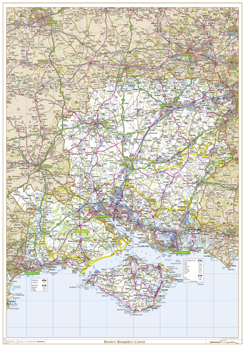
Historic Hampshire County Map
This is a historic county map of Hampshire, highlighting the traditional county border, the surrounding area is faded out with a sepia tint for excellent contrast. The historic map covers, Aldershot, Basingstoke, Bournemouth, Christchurch, Cowes, Newport, Petersfield, Portsmouth, Ringwood, Ryde, Southampton, Winchester and Ventnor. The traditional county map has the historic county boundaries overlaid on an up to date Ordnance Survey 1:250,000 scale map.
Page Size: 33.25 x 47 in (841 x 1189 mm)
Historic Hertfordshire County Map
This is a historic county map of Hertfordshire, highlighting the traditional county border, the surrounding area is faded out with a sepia tint for excellent contrast. The historic map covers, Royston, Letchworth Garden City, Bishops Stortford, Welwyn Garden City, Borehamwood, Hatfield, Hemel Hempstead, Hitchin, Hertford, St Albans, Tring, Watford and Rickmansworth. The traditional county map has the historic county boundaries overlaid on an up to date Ordnance Survey 1:250,000 scale map.
Page Size: 47 x 33.25 in (1189 x 841 mm)
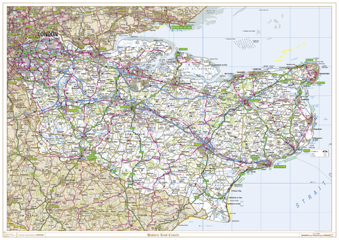
Historic Kent County Map
This is a historic county map of Kent, highlighting the traditional county border, the surrounding area is faded out with a sepia tint for excellent contrast. The historic map covers, Abbots Bromley, Canterbury, Chatham, Dover, Folkestone, Greenwich, Lewisham, Maidstone, Orpington, Ramsgate, Rochester, Sevenoaks, Tunbridge Wells, Whitstable, and Woolwich. The traditional county map has the historic county boundaries overlaid on an up to date Ordnance Survey 1:250,000 scale map.
Page Size: 47 x 33.25 in (1189 x 841 mm)
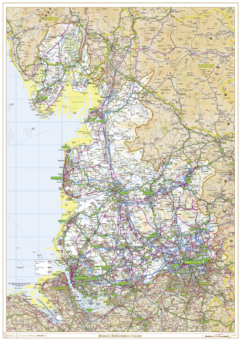
Historic Lancashire County Map
This is a historic county map of Lancashire, highlighting the traditional county border, the surrounding area is faded out with a sepia tint for excellent contrast. The historic map covers, Morecombe, Lancaster, Fleetwood, Blackpool, Skelmersdale, Preston, Blackburn, Burnley and Clitheroe. The traditional county map has the historic county boundaries overlaid on an up to date Ordnance Survey 1:250,000 scale map.
Page Size: 33.25 x 47 in (841 x 1189 mm)
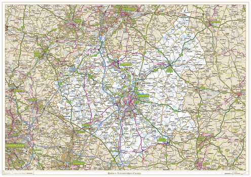
Historic Leicestershire County Map
This is a historic county map of Leicestershire, highlighting the traditional county border, the surrounding area is faded out with a sepia tint for excellent contrast. The historic map covers, Ashby-de-La-Zouch, Coalville, Hinckley, Leicester, Loughborough, Lutterworth, Market Bosworth, Market Harborough and Melton Mowbray. The traditional county map has the historic county boundaries overlaid on an up to date Ordnance Survey 1:250,000 scale map.
Page Size: 47 x 33.25 in (1189 x 841 mm)
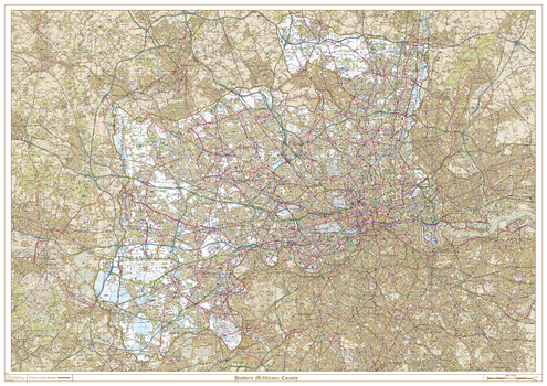
Historic Middlesex County Map
This is a historic county map of Middlesex, highlighting the traditional county border, the surrounding area is faded out with a sepia tint for excellent contrast. The historic map covers, Potters Bar, Enfield, Southgate, Edmonton, Tottenham, Wood Green, Friern Barnet, Hornsey, Finchley, Hendon, Harrow, Ruislip-Northwood, Uxbridge, Ealing, Wembley, Willesden, Acton, Brentford and Chiswick, Heston and Isleworth, Southall, Hayes and Harlington, Yiewsley and West Drayton, Staines, Feltham, Twickenham, and Sunbury-on-Thames. The traditional county map has the historic county boundaries overlaid on an up to date Ordnance Survey 1:50,000 scale map.
Page Size: 47 x 33.25 in (1189 x 841 mm)
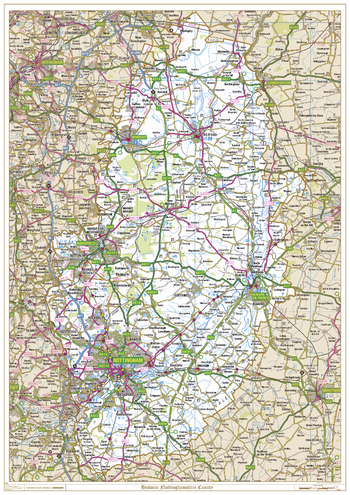
Historic Nottinghamshire County Map
This is a historic county map of Nottinghamshire, highlighting the traditional county border, the surrounding area is faded out with a sepia tint for excellent contrast. The historic map covers, Nottingham, Newark on Trent, Mansfield, Worksop and Retford. The traditional county map has the historic county boundaries overlaid on an up to date Ordnance Survey 1:250,000 scale map.
Page Size: 33.25 x 47 in (841 x 1189 mm)
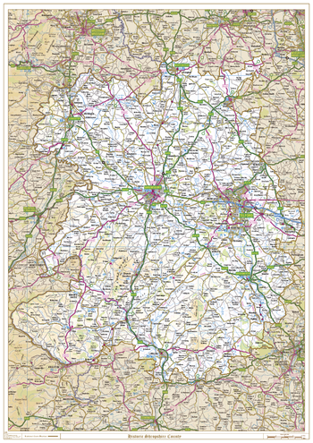
Historic Shropshire County Map
This is a historic county map of Shropshire, highlighting the traditional county border, the surrounding area is faded out with a sepia tint for excellent contrast. The historic map covers, Whitchurch, Oswestry, Newport, Shrewsbury, Telford, Bridgnorth, Church Stretton, Bishops Castle, and Ludlow. The traditional county map has the historic county boundaries overlaid on an up to date Ordnance Survey 1:250,000 scale map.
Page Size: 33.25 x 47 in (841 x 1189 mm)