Artokoloro
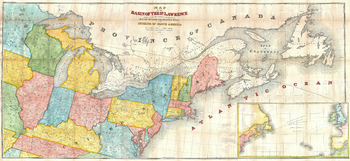
Andrews Map of the Great Lakes and St. Lawrence Basin (1853)
1853 map of the St. Lawrence Basin by prominent Canadian railway engineer and civil engineer Tomas C. Keefer for Israel D. Andrews' report to Hon. Thomas Corwin, Secretary of the Treasury. Full title: Map of the Basin of the St. Lawrence Showing also the Natural and Artifical Routes Between the Atlantic Ocean and the Interior of North America.
Page Size: 26.75 x 12.25 in (676 x 310 mm)
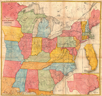
Andrews Railroad Map of the United States (1852)
1852 map of railroads of the United States by Israel D. Andrews. Full title: Map of the Railroads in the United States in Operation and Progress to accompany a report from the Treasury Department
Page Size: 22.25 x 21 in (565 x 529 mm)
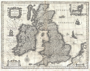
Blaeu Map of the British Isles (1631)
1631 map of England, Scotland and Ireland by Dutch catrographer Willem Janszoon Blaeu. Full title: Magnae Britanniae et Hiberniae Tabula.
Page Size: 18.75 x 14.75 in (472 x 374 mm)
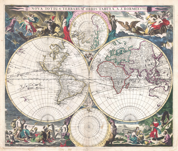
Bormeester Map of the World (1685)
1685 hemisphere map of the World by Dutch publisher Joachim Bormeester. The East and West hemispheres are depicted, with the North and South Poles shown above and below the main map. Full title: Nova Totius Terrarum Orbis Tabula. A. J. Bormeester.
Page Size: 19 x 16.25 in (483 x 410 mm)
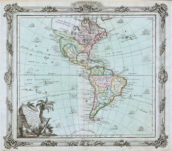
Brion de la Tour Map of North America and South America (1764)
1764 map of North and South America by French geographer Louis Brion de la Tour. Full title: L'Amérique Dressée for l'étude de la Géographie.
Page Size: 17.25 x 15.25 in (436 x 383 mm)
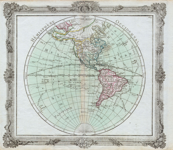
Brion de la Tour Map of the Western Hemisphere (1764)
1764 map of the Western Hemisphere by French geographer Louis Brion de la Tour. Full Title: Hémisphere Occidental.
Page Size: 17.5 x 15.25 in (442 x 384 mm)
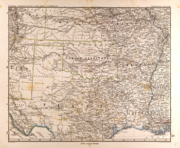
Central United States Map in German (1872)
Map of the central United States in German from the Gotha Justus Perthes 1872 Atlas. Full title: Petermann: Vereinigte Staaten von Nord-Amerika in 6 Blättern, Bl. 5.
Page Size: 25.25 x 20.75 in (639 x 526 mm)
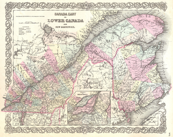
Colton Map of Canada East or Quebec (1855)
1855 map of southern Quebec (Lower Canada) and New Brunswick published by American mapmakers J.H Colton & Co. Full title: Canada East or Lower Canda and New Brunswick.
Page Size: 18 x 14.25 in (454 x 360 mm)
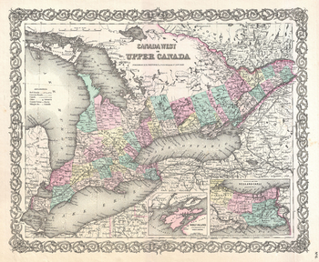
Colton Map of Upper Canada or Ontario (1855)
1855 map of southern Ontario (Upper Canada) published by American mapmakers J.H Colton & Co. Full title: Canada West or Upper Canada.
Page Size: 18 x 14.75 in (454 x 373 mm)
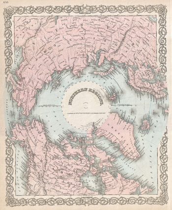
Colton Map of the North Pole or Arctic (1872)
1872 map centered on the North Pole by American mapmakers G.W and C.B Colton & Co. Full title: Northern Regions.
Page Size: 14.5 x 17.75 in (367 x 448 mm)
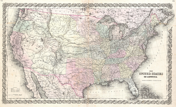
Colton Map of the United States (1855)
1855 map of the United States published by American mapmakers J.H Colton & Co. Full title: The United States of America.
Page Size: 23 x 14 in (579 x 353 mm)
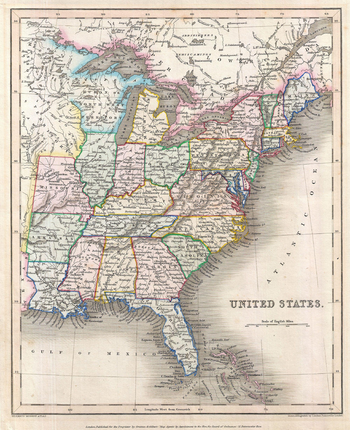
Gilbert Map of the United States (1843)
Map of the United States from the 1843 edition of Gilbert's Modern Atlas. Map title: United States
Page Size: 11 x 13.5 in (278 x 341 mm)

James Polar Projection of the Globe, Pacific Center (1860)
1860 polar projection map centered on the Pacific Ocean by director-general of the British Ordnance Survey Major General Sir Henry James. Full title: Geometrical Projection of Two Thirds of the Sphere by Col. Sir H. James, R.E.F.R.S: M.R.I.A: & c.
Page Size: 15.5 x 15.25 in (389 x 387 mm)
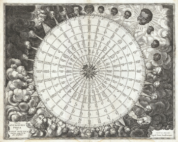
Jansson Wind Rose (1650)
1650 Anemographic chart (map of the winds) by Dutch cartographer Johannes Janssonius. Full title: Tabula Anemographica seu Pyxis Nautica ventorum nomina sex linguis repraesentans
Page Size: 19 x 15.25 in (483 x 386 mm)
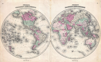
Johnson Map of the World on Hemisphere Projection (1862)
1862 hemisphere map of the World by American map publisher Alvin Jewett Johnson. Full title: Johnson's Western Hemisphere - Johnson's Eastern Hemisphere
Page Size: 20.75 x 12.75 in (525 x 323 mm)
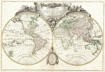
Lattre and Janvier Map of the World on a Hemisphere Projection (1775)
1755 hemisphere map of the World by French cartographer Jean Janvier. Full title: Mappe-Monde ou Description du Globe Terrestre, Assujettie aux Observations Astronomiques.
Page Size: 18 x 12.25 in (454 x 310 mm)
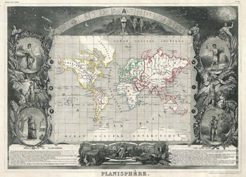
Levasseur Map of the World (1847)
1847 map of the World by French map publisher Victor Levasseur. Full title: Planisphère
Page Size: 18 x 13 in (454 x 325 mm)
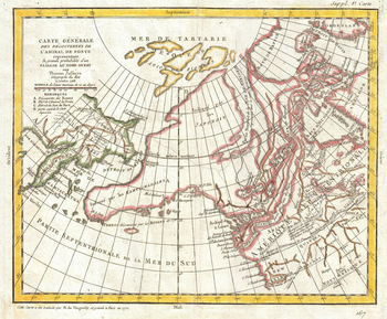
Map of Alaska, the Pacific Northwest and the Northwest Passage (1772)
1772 map of north-eastern Asia with speculations on north-western North America by French cartographer Robert de Vaugondy and English cartographer Thomas Jefferys (Geographer to King George III). Full title: Carte générale des découvertes de l'Admiral de Fonte representant la grand probabilité d'un passage au nord ouest par Thomas Jefferys Géographe du Roi à Londres 1768.
Page Size: 18 x 15 in (454 x 375 mm)
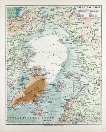
Map of Countries Around the North Pole in German (1899)
1899 map of the counries around the North Pole in German showing sea depth and land elevations by German publisher Bibliographisches Institut in Leipzig. Full title: Nor Polarländer.
Page Size: 20.5 x 25.25 in (518 x 640 mm)
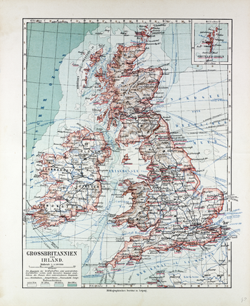
Map of Great Britain and Ireland in German (1899)
1899 map of Great Britain and Ireland in German showing sea depth and indications of relief on land by German publisher Bibliographisches Institut in Leipzig: Full title: Grossbritannien und Ireland.
Page Size: 20.5 x 25 in (518 x 635 mm)