


MapSherpa Catalog
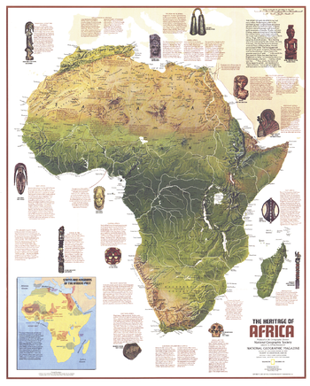
Heritage of Africa - Published 1971
National Geographic
This Africa map features a physical map of the continent and an abundance of historical notes. Published in December 1971 as half of a two–map set with the "Ethnolinguistic Map of the Peoples of Africa" map, and as a companion to the article "The Zulus: Black Nation in a Land of Aparteid."
Page Size: 22.75 x 28.25 in (575 x 716 mm)
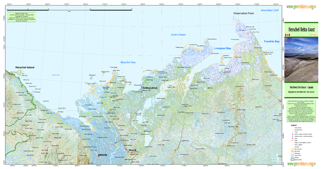
Herschel Delta Coast
GoTrekkers
Herschel Delta Coast
Page Size: 41 x 21.5 in (1041 x 546 mm)
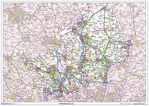
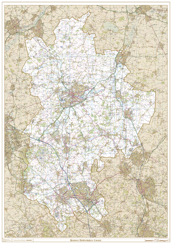
Hertfordshire County Map
XYZ Maps
This is a large ceremonial county map of Hertfordshire highlighting the county border, with the surrounding area faded out for excellent contrast. The map covers Royston Letchworth Garden City, Bishops Stortford, Welwyn Garden City, Borehamwood, Hatfield, Hemel Hempstead, Hitchin, Hertford, St Albans, Tring, Watford and Rickmansworth. The county map shows the latest County and Unitary Authority Boundaries, Overlaid on a Clear and Easy to Read Ordnance Survey map.
Page Size: 47 x 33.25 in (1189 x 841 mm)
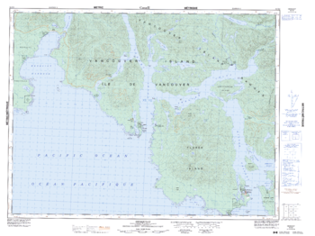
Hesquiat - 92 E/8 - British Columbia
Natural Resources Canada
Canadian topographic map of Hesquiat, British Columbia. NTS sheet 092E08 Edition 5.
Page Size: 34.5 x 25.75 in (874 x 654 mm)
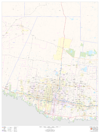
Hidalgo County, Texas
MapSherpa
This map of Hidalgo County, Texas shows regional level information. Base map features include highways and major roads with labelling; neighborhood names; railways; high level land use such as parks and recreation areas, industrial areas and hospital campuses; and a selection of points of interest including transportation hubs like airports and train stations, tourist information, police stations and shopping centres. ZIP code boundaries are shown as a secondary map feature.
Page Size: 36 x 48 in (914 x 1219 mm)
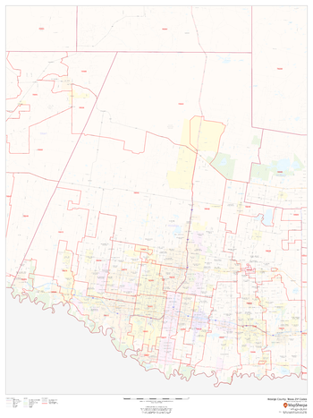
Hidalgo County, Texas ZIP Codes
MapSherpa
This map of Hidalgo County, Texas shows ZIP code areas overlaid on a road map. Ideal for planning of deliveries, home ervices, sales territories, real estate and much more. Base map features include all roads with major roads and highways labelled; neighborhood names; railways; and high level land use such as parks and recreation areas, industrial areas and hospital campuses.
Page Size: 36 x 48 in (914 x 1219 mm)
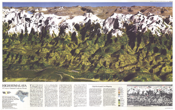
High Himalaya - Published 1988
National Geographic
This computer-generated panorama of the Himalayas from Kathmandu to just east of Mount Everest is neither photograph nor painting, though it resembles both with its dimension and color. Published in November 1988 with a companion map of and three articles about Mount Everest, this stunning map brings these majestic mountains to life in striking relief.
Page Size: 36 x 22.75 in (911 x 573 mm)
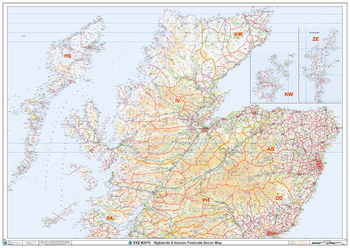
Highlands & Islands Postcode Sector Wall Map (S19)
XYZ Maps
The Highlands & Islands Postcode Sector Wall Map shows detailed postcode sector boundaries along with its associated label (IV1 1, IV1 2) on a comprehensive background and is perfect for determining postcode boundaries, for sales, logistics, planning mailshots or as a regional reference guide.
Page Size: 47 x 33.25 in (1189 x 841 mm)
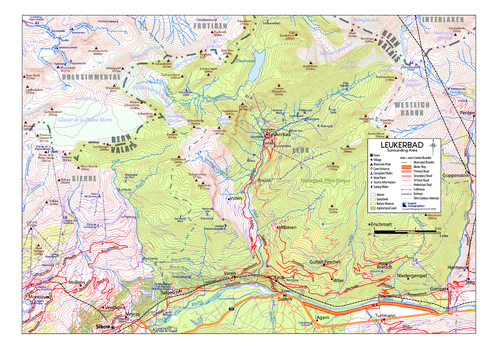
Hiking around Leukerbad, Switzerland
Inspirit Cartographics
This map shows the hiking trails, natural sites, camping sites and tourist information points around the town of Leukerbad. It also provides information regarding the surround town and villages.
Page Size: 16.75 x 11.75 in (424 x 297 mm)
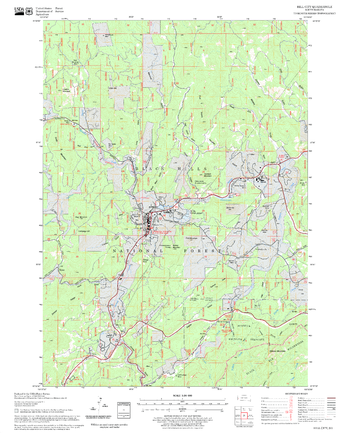
Hill City Quadrangle, South Dakota
United States Department of Agriculture Forest Service
United States Department of Agriculture Forestry Service topographical map of Hill City, Black Hills National Forest, South Dakota.
Page Size: 21.75 x 27 in (552 x 686 mm)
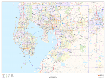
Hillsborough County, Florida
MapSherpa
This map of Hillsborough County, Florida shows regional level information. Base map features include highways and major roads with labelling; railways; high level land use such as parks and recreation areas; and a selection of points of interest including transportation hubs like airports and train stations, tourist information and police stations. ZIP code boundaries are shown as a secondary map feature.
Page Size: 48 x 36 in (1219 x 914 mm)
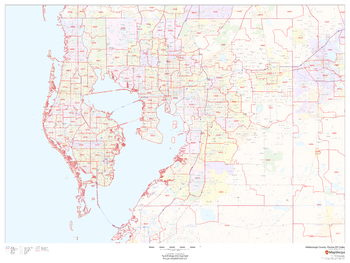
Hillsborough County, Florida ZIP Codes
MapSherpa
This map of Hillsborough County, Florida shows ZIP code areas overlaid on a road map. Ideal for planning of deliveries, home services, sales territories, real estate and much more. Base map features include all roads with major roads and highways labelled; neighborhood names; railways; and high level land use such as parks and recreation areas, industrial areas and hospital campuses.
Page Size: 48 x 36 in (1219 x 914 mm)

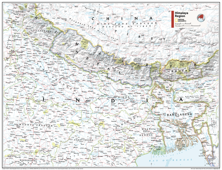
Himalaya Region - Atlas of the World, 11th Edition
National Geographic
This Himalaya Region map of physical and political features can fit in any space. Showcasing the countries in stunning detail with state-of-the-art cartographic techniques delivering accuracy and exceptional quality, the innovative and engaging design makes the content easily accessible and user-friendly.
Ideal for classrooms with an emphasis on teaching geography or environmental themes. The inclusion of physical features gives your students a genuine feel for how our world appears.
This map uses a bright, easy to read color palette featuring blue oceans and stunning shaded relief that has been featured on National Geographic wall maps for over 75 years. It is drawn in Conic projection, in which an area of the earth is projected onto a cone whose vertex is usually above one of the poles, then unrolled onto a flat surface.
Names of geographic features are carefully placed on the map to maintain legibility.
This map is found in National Geographic's 11th Edition World Atlas and is now available as a stand alone product.
Page Size: 31.5 x 24 in (798 x 610 mm)
Himalaya Region - Atlas of the World, 11th Edition - Compact
National Geographic
This Himalaya Region map of physical and political features can fit in any space. Showcasing the countries in stunning detail with state-of-the-art cartographic techniques delivering accuracy and exceptional quality, the innovative and engaging design makes the content easily accessible and user-friendly.
Ideal for classrooms with an emphasis on teaching geography or environmental themes. The inclusion of physical features gives your students a genuine feel for how our world appears.
This map uses a bright, easy to read color palette featuring blue oceans and stunning shaded relief that has been featured on National Geographic wall maps for over 75 years. It is drawn in Conic projection, in which an area of the earth is projected onto a cone whose vertex is usually above one of the poles, then unrolled onto a flat surface.
Names of geographic features are carefully placed on the map to maintain legibility.
This map is found in National Geographic's 11th Edition World Atlas and is now available as a stand alone product.
Page Size: 21.5 x 16.25 in (540 x 413 mm)
Historic Aeronautical Charts
MapSherpa
This multi-scale product is created from Tactical Pilotage Charts and Operational Navigational Charts. These topographic maps with aeronautical information provides coverage over the Mediterranean, Africa, the Middle East, and across the Himalayas to Japan. Individual map sheets have been combined into a seamless layer. and provide some of the most detailed mapping available for many remote parts of the world. Suitable for printing between 1:250,000 and 1:2,000,000.
Historic Bedfordshire County Map
XYZ Maps
This is a historic county map of Bedfordshire, highlighting the traditional county border, the surrounding area is faded out with a sepia tint for excellent contrast. The historic map covers, Eaton Socon, Bedford, Sharnbrook, Harold, Ampthill, Flitwick, Barton-le-Clay, Leighton Buzzard, Dunstable, and Luton. The traditional county map has the historic county boundaries overlaid on an up to date Ordnance Survey 1:50,000 scale map.
Page Size: 33.25 x 47 in (841 x 1189 mm)
Historic Berkshire County Map
XYZ Maps
This is a historic county map of Berkshire, highlighting the traditional county border, the surrounding area is faded out with a sepia tint for excellent contrast. The historic map covers Abington-on-Thames, Didcot, Wantage, Shrivenham, Hungerford, Newbury, Reading, Wokingham, Maidenhead, Windsor, and Bracknell. The traditional county map has the historic county boundaries overlaid on an up to date Ordnance Survey 1:250,000 scale map.
Page Size: 47 x 33.25 in (1189 x 841 mm)
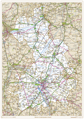
Historic Cambridgeshire County Map
XYZ Maps
This is a historic county map of Cambridgeshire, highlighting the traditional county border, the surrounding area is faded out with a sepia tint for excellent contrast. The historic map covers Wisbech, Whittlesey, Chatteris, March, Ely, and Cambridge. The traditional county map has the historic county boundaries overlaid on an up to date Ordnance Survey 1:250,000 scale map.
Page Size: 33.25 x 47 in (841 x 1189 mm)
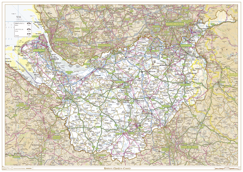
Historic Cheshire County Map
XYZ Maps
This is a historic county map of Cheshire, highlighting the traditional county border, the surrounding area is faded out with a sepia tint for excellent contrast. The historic map covers Stockport, Altringham, Runcorn, Ellesmere Port, Birkenhead, Northwich, Chester, Congleton, Macclesfield, and Nantwich. The traditional county map has the historic county boundaries overlaid on an up to date Ordnance Survey 1:250,000 scale map.
Page Size: 47 x 33.25 in (1189 x 841 mm)
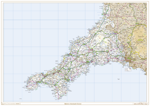
Historic Cornwall County Map
XYZ Maps
This is a historic county map of Cornwall, highlighting the traditional county border, the surrounding area is faded out with a sepia tint for excellent contrast. The historic map covers, Bodmin, Bude, Falmouth, Fowey, Launceston, Lostwithiel, Mousehole, Padstow, Penzance, Redruth, St Austell, St Ives, Truro, St Neots, Saltash, and Tintagel. The traditional county map has the historic county boundaries overlaid on an up to date Ordnance Survey 1:250,000 scale map.
Page Size: 47 x 33.25 in (1189 x 841 mm)
No search results