


MapSherpa Catalog
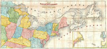
Andrews Map of the Great Lakes and St. Lawrence Basin (1853)
Artokoloro
1853 map of the St. Lawrence Basin by prominent Canadian railway engineer and civil engineer Tomas C. Keefer for Israel D. Andrews' report to Hon. Thomas Corwin, Secretary of the Treasury. Full title: Map of the Basin of the St. Lawrence Showing also the Natural and Artifical Routes Between the Atlantic Ocean and the Interior of North America.
Page Size: 26.75 x 12.25 in (676 x 310 mm)
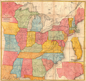
Andrews Railroad Map of the United States (1852)
Artokoloro
1852 map of railroads of the United States by Israel D. Andrews. Full title: Map of the Railroads in the United States in Operation and Progress to accompany a report from the Treasury Department
Page Size: 22.25 x 21 in (565 x 529 mm)
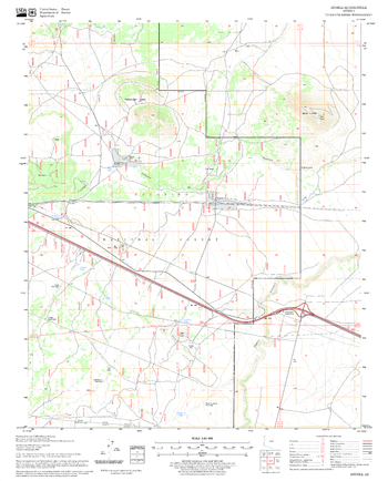
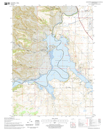
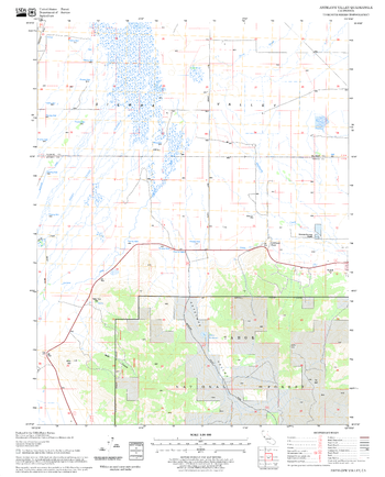
Angell Quadrangle, Arizona
United States Department of Agriculture Forest Service
United States Department of Agriculture Forestry Service topographical map of Angell, Coconino National Forest, Arizona.
Page Size: 21.75 x 27 in (552 x 686 mm)
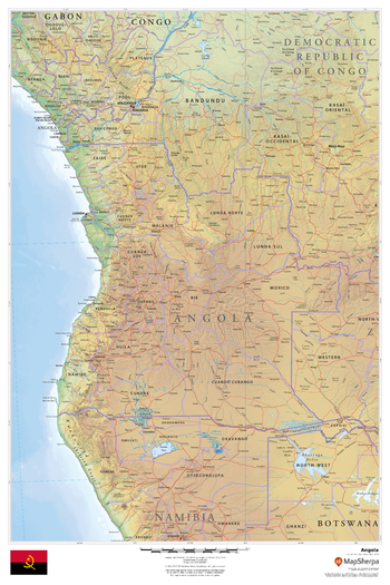
Angola
MapSherpa
This beautiful map shows physical and political features for Angola and surrounding areas. Relief shading and the use of different colours by height above sea level are both informative and attractive.
Page Size: 24 x 36 in (610 x 914 mm)
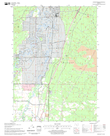
Angostura Reservoir Quadrangle, South Dakota
United States Department of Agriculture Forest Service
United States Department of Agriculture Forestry Service topographical map of Angostura Reservoir, Black Hills National Forest, South Dakota.
Page Size: 21.75 x 27 in (552 x 686 mm)
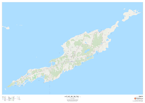
Anguilla
MapSherpa
This map of Anguilla features a full road network for the island including the capital The Valley, walking paths, land use, points of interest, and many of the buildings. Useful for the traveller, and as a wall map for display in your home.
Page Size: 47 x 33.25 in (1189 x 841 mm)

Angus & Aberdeenshire Postcode Sector Wall Map (S20)
XYZ Maps
The Angus & Aberdeenshire Postcode Sector Wall Map shows detailed postcode sector boundaries along with its associated label (AB1 1, AB1 2) on a comprehensive background and is perfect for determining postcode boundaries, for sales, logistics, planning mailshots or as a regional reference guide.
Page Size: 33.25 x 47 in (841 x 1189 mm)
Anns Butte Quadrangle, Oregon
United States Department of Agriculture Forest Service
United States Department of Agriculture Forestry Service topographical map of Anns Butte, Deschutes National Forest, Oregon.
Page Size: 21.75 x 27 in (552 x 686 mm)
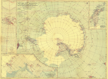
Antarctic Regions - Published 1932
National Geographic
This early map of the Antarctic regions was published in October 1932, just a few years after Byrd's historical flight over the South Pole. Parts of the inset maps were constructed using aerial photographs and the article "Mapping the Antarctic from the Air: The Aerial Camera Earns Its Place as the Eyes and Memory of the Explorer" appeared in the same issue of National Geographic.
Page Size: 26.25 x 19.25 in (664 x 484 mm)
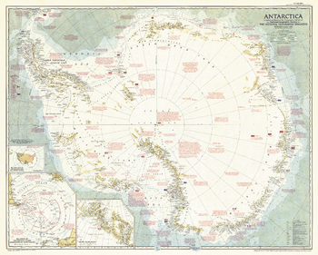
Antarctica - Published 1957
National Geographic
This striking map captures Antarctica at a pivotal time during its exploration. Contains a great amount of detail of both the geography and history of the multi–national expeditions that have traversed the icy continent. Published in 1957, just six months after the death of famed American polar explorer Admiral Richard E. Byrd, with the article "Year of Discovery Opens in Antarctica."
Page Size: 36.25 x 29 in (915 x 735 mm)
Antarctica - Published 1963
National Geographic
Explore the harsh, yet magnificent terrain of Antarctica in this finely detailed and educational map. Filled with information on the continent's geography as well as historical facts about its exploration. Published in February 1963 with the article "New Era in the Loneliest Continent."
Page Size: 25 x 19 in (631 x 479 mm)
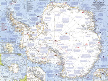
Antarctica - Published 1987
National Geographic
This map is loaded with information about Antarctica including expeditions, stations, wildlife, climate, and more. It also contains inset maps showing the entire subglacial continent and various countries claims on the region. Published in April 1987 as a companion to the "Pinnipeds Around the World" map and an article entitled "Seal and Their Kin".
Page Size: 30.25 x 21 in (763 x 531 mm)
Antarctica Political
Maps International
Our Antarctica map shows territory divisions, the major expedition routes, camps and weather stations. The map features hill shading.
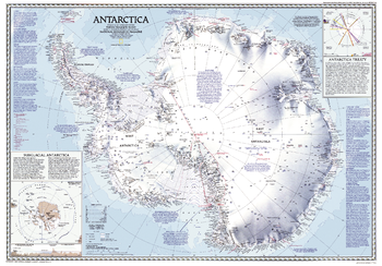
Antarctica Political - Atlas of the World, 10th Edition
National Geographic
Antarctic Geography, Antarctic Treaty
Page Size: 28 x 22 in (711 x 559 mm)
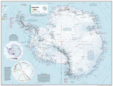
Antarctica Political - Atlas of the World, 11th Edition
National Geographic
This map of political features can fit in any space. Showcasing the Antarctic Ocean in stunning detail with state-of-the-art cartographic techniques delivering accuracy and exceptional quality, the innovative and engaging design makes the content easily accessible and user-friendly.
Ideal for classrooms with an emphasis on teaching geography or environmental themes. The inclusion of physical features on this map gives your students a genuine feel for how the African continent appears.
This political map of the Antarctic Ocean uses a bright, easy to read color palette featuring blue oceans and stunning shaded relief that has been featured on National Geographic wall maps for over 75 years.
Names of geographic features such as international boundaries, cities, rivers and lakes are carefully placed on the map to maintain legibility.
This map is found in National Geographic's 11th Edition World Atlas and is now available as a stand alone product.
Page Size: 31.5 x 24 in (798 x 610 mm)
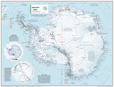
Antarctica Political - Atlas of the World, 11th Edition - Compact
National Geographic
This map of political features can fit in any space. Showcasing the Antarctic Ocean in stunning detail with state-of-the-art cartographic techniques delivering accuracy and exceptional quality, the innovative and engaging design makes the content easily accessible and user-friendly.
Ideal for classrooms with an emphasis on teaching geography or environmental themes. The inclusion of physical features on this map gives your students a genuine feel for how the African continent appears.
This political map of the Antarctic Ocean uses a bright, easy to read color palette featuring blue oceans and stunning shaded relief that has been featured on National Geographic wall maps for over 75 years.
Names of geographic features such as international boundaries, cities, rivers and lakes are carefully placed on the map to maintain legibility.
This map is found in National Geographic's 11th Edition World Atlas and is now available as a stand alone product.
Page Size: 21.5 x 16.25 in (540 x 413 mm)
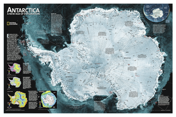
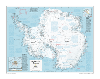
Antarctica Satellite
National Geographic
A striking view of Antarctica's terrain, compiled from 4,500 satellite scans. Additional inset maps show surface elevation, ice sheet thickness, velocity of ice flow, and sea ice movement and windflow.
Page Size: 33 x 22 in (834 x 555 mm)
Antelope Mountain Quadrangle, California
United States Department of Agriculture Forest Service
United States Department of Agriculture Forestry Service topographical map of Antelope Mountain, Lassen National Forest, California.
Page Size: 21.75 x 27 in (552 x 686 mm)
Antelope Valley Quadrangle, California
United States Department of Agriculture Forest Service
United States Department of Agriculture Forestry Service topographical map of Antelope Valley, Tahoe National Forest, California.
Page Size: 21.75 x 27 in (552 x 686 mm)
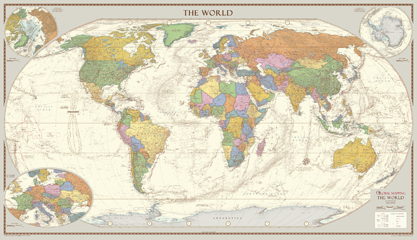
Antique Style World Map - Extra Large
Global Mapping
The 1:30M version won Best Printed Map from the British Cartographic Society (BCS) who also awarded it the BCS Cup for the best overall map. The classic design of muted colours and hill shading give an antique feel to the map. The map features insets of the two polar regions as well as an enlargement of Central Europe, all with an increased level of detail than the medium map. Uniquely, the map also includes explanatory text about the Tropics of Cancer and Capricorn, the Arctic and Antarctic Circles as well as an Analemma which shows which day of the year the sun is directly overhead and how sun time compares to clock time.
Page Size: 78.75 x 45.5 in (2000 x 1150 mm)
No search results