


MapSherpa Catalog
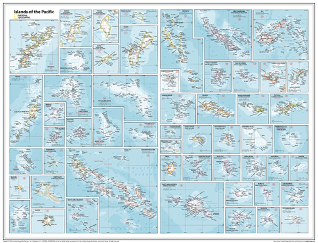
Islands of the Pacific - Atlas of the World, 11th Edition
National Geographic
This Islands of the Pacific map of physical and political features can fit in any space. Showcasing the region in stunning detail with state-of-the-art cartographic techniques delivering accuracy and exceptional quality, the innovative and engaging design makes the content easily accessible and user-friendly.
Ideal for classrooms with an emphasis on teaching geography or environmental themes. The inclusion of physical features gives your students a genuine feel for how our world appears.
54 island nations are showcased in each unique inset, allowing the reader to see all of the islands in maximum detail within the wall map space.
This map uses a bright, easy to read color palette featuring blue oceans and stunning shaded relief that has been featured on National Geographic wall maps for over 75 years.
This map is found in National Geographic's 11th Edition World Atlas and is now available as a stand alone product.
Page Size: 31.5 x 24 in (798 x 610 mm)
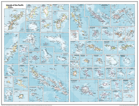
Islands of the Pacific - Atlas of the World, 11th Edition - Compact
National Geographic
This Islands of the Pacific map of physical and political features can fit in any space. Showcasing the region in stunning detail with state-of-the-art cartographic techniques delivering accuracy and exceptional quality, the innovative and engaging design makes the content easily accessible and user-friendly.
Ideal for classrooms with an emphasis on teaching geography or environmental themes. The inclusion of physical features gives your students a genuine feel for how our world appears.
54 island nations are showcased in each unique inset, allowing the reader to see all of the islands in maximum detail within the wall map space.
This map uses a bright, easy to read color palette featuring blue oceans and stunning shaded relief that has been featured on National Geographic wall maps for over 75 years.
This map is found in National Geographic's 11th Edition World Atlas and is now available as a stand alone product.
Page Size: 21.5 x 16.25 in (540 x 413 mm)

Isle of Man
MapSherpa
This wall map of the Isle of Man has been produced from current Ordnance Survey mapping, and displays the detailed topographic features of the island. A complete road network for the island is displayed, as well as all villages and towns including the capital Douglas. Detailed shoreline, points of interest, and waterways are displayed in recognizable Ordnance Survey styling.
Page Size: 33.25 x 47 in (841 x 1189 mm)
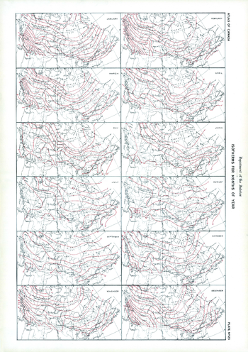
Isotherms for Months of Year (1906)
Natural Resources Canada
Contained within the 1st Edition (1906) of the Atlas of Canada is a plate that shows isothermal lines for each month of the year. Within the plate there are 12 maps, one for each month that varies from January to December. These lines are drawn at intervals of 5 degrees Fahrenheit connect the points having the same mean temperature. They are deduced from observations by the Meteorological Service extending over a series of years.
Page Size: 17.25 x 24.25 in (433 x 614 mm)
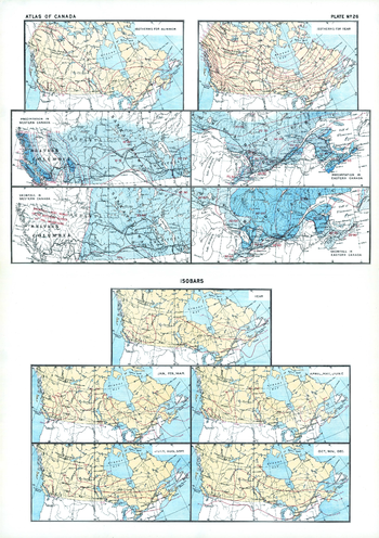
Isotherms, Rainfall, Snowfall and Isobars (1906)
Natural Resources Canada
Contained within the 1st Edition (1906) of the Atlas of Canada is a plate that shows 11 maps. Two maps at the top of this plate presenting isothermal lines for summer and for the entire year. The isotherms for summer display the great northern "loop" of the summer isotherm of 55 degrees Fahrenheit, which make cultivation of cereals possible. The annual isothermal lines follow an easterly and Westerly direction which would obscure the beneficial effect indicated by the summer isotherms. The next four maps show precipitation and snowfall for Eastern and Western Canada in inches. The remaining five maps show isobaric lines. One map shows the annual average, while the other four cover seasons (January-March, April-June, July-September, and October-December). Barometric pressure is measured in inches of mercury. In some of the maps, major railway systems are shown.
Page Size: 17.25 x 24.25 in (433 x 613 mm)
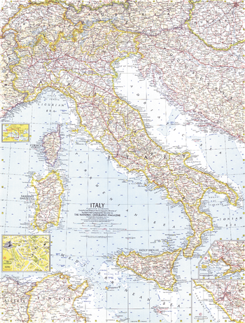
Italy - Published 1961
National Geographic
National Geographic commemorated Italy's centennial as a unified country in November 1961 with this map and an article about the historic milestone. This detailed work features inset city maps of Naples and Rome.
Page Size: 19 x 25 in (480 x 632 mm)
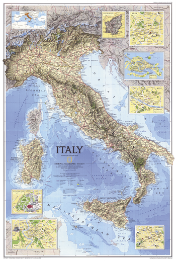
Italy - Published 1995
National Geographic
A beautiful physical and political map of Italy that features striking relief and bathymetry. Published in February 1995 as half of a two–map set with "Historical Italy", and accompanied by an article on Venice.
Page Size: 22.25 x 33 in (563 x 835 mm)
Italy - Atlas of the World, 10th Edition
National Geographic
null
Page Size: 22 x 28 in (559 x 711 mm)

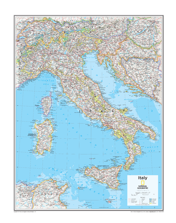
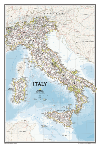
Italy - Atlas of the World, 11th Edition
National Geographic
This Italy map of physical and political features can fit in any space. Showcasing the countries in stunning detail with state-of-the-art cartographic techniques delivering accuracy and exceptional quality, the innovative and engaging design makes the content easily accessible and user-friendly.
Ideal for classrooms with an emphasis on teaching geography or environmental themes.The inclusion of physical features gives your students a genuine feel for how our world appears.
This map uses a bright, easy to read color palette featuring blue oceans and stunning shaded relief that has been featured on National Geographic wall maps for over 75 years. It is drawn in the Albers Conic Equal-Area projection, which uses two standard parallels between which distortion is minimized, however scale and shape is not preserved.
Names of geographic features are carefully placed on the map to maintain legibility.
This map is found in National Geographic's 11th Edition World Atlas and is now available as a stand alone product.
Page Size: 24 x 31.5 in (610 x 798 mm)
Italy - Atlas of the World, 11th Edition - Compact
National Geographic
This Italy map of physical and political features can fit in any space. Showcasing the countries in stunning detail with state-of-the-art cartographic techniques delivering accuracy and exceptional quality, the innovative and engaging design makes the content easily accessible and user-friendly.
Ideal for classrooms with an emphasis on teaching geography or environmental themes.The inclusion of physical features gives your students a genuine feel for how our world appears.
This map uses a bright, easy to read color palette featuring blue oceans and stunning shaded relief that has been featured on National Geographic wall maps for over 75 years. It is drawn in the Albers Conic Equal-Area projection, which uses two standard parallels between which distortion is minimized, however scale and shape is not preserved.
Names of geographic features are carefully placed on the map to maintain legibility.
This map is found in National Geographic's 11th Edition World Atlas and is now available as a stand alone product.
Page Size: 16.25 x 21.5 in (413 x 540 mm)
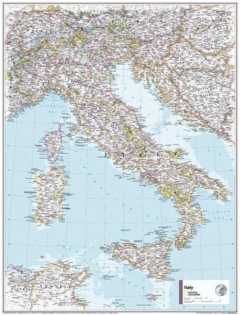
Italy Classic
National Geographic
Our most detailed wall map of Italy. Features thousands of place names, accurate political boundaries, major infrastructure networks such as roads, canals, aqueducts, ferry routes, airports, and railroads. Italy's diverse terrain is detailed through accurate shaded relief, coastal bathymetry, and symbolism for water features and other land forms including the outlying islands of Corsica, Elba, Isola di Pantelleria, Isola San Domino, Isola di Ustica, Isole Eolle O Lipari, Sardinia and Sicily. Elevations of major peaks are expressed in feet, depth soundings are expressed in fathoms.
Page Size: 23.25 x 34.25 in (591 x 867 mm)
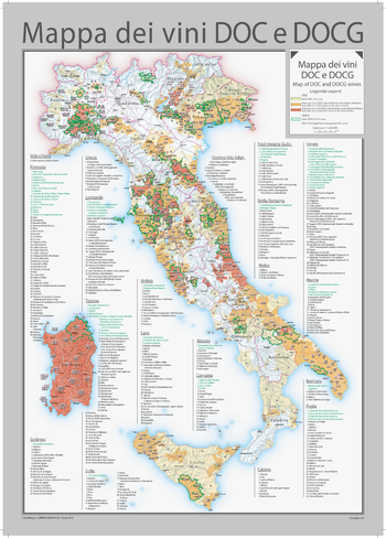
Italy DOC and DOCG Wines Wall Map - English and Italian
Geo4Map
A map of Italy with all of the DOC and DOCG wines.
Page Size: 28 x 39 in (711 x 990 mm)
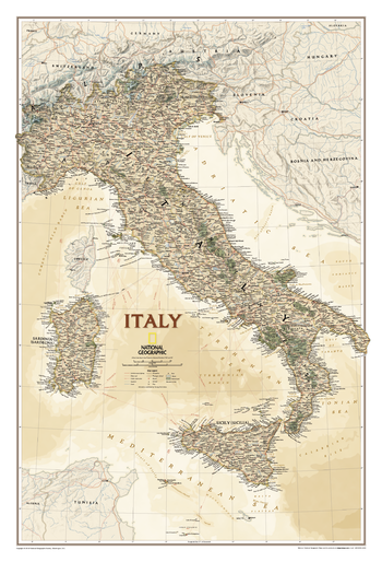
Italy Executive
National Geographic
This elegant, richly colored antique-style map features the incredible cartographic detail that is the trademark of National Geographic quality. In addition to detailed reference information - country boundaries, roads, cities and towns, lakes and waterways, etc. - our map of Italy also includes helpful inset maps for San Marino, Milan, Venice, Florence, Rome and other famous cities.
Page Size: 23.25 x 34.25 in (591 x 867 mm)
Italy Explorer
MapSherpa
This versatile product allows you to get a topographic map of anywhere in Italy. It has been designed so you can create a map for your next excursion.This product has been designed to make custom topographic maps suitable for short walks to week long treks and anything in between. Walking and bike paths are featured prominently on this map along with key points of interest such as campsites, trailheads, and landmarks. Also included are traditional topographic features such as elevation contours, landforms, lakes, and rivers along with roads, rails, trails, and park boundaries.The details of this map make it ideal to plan your next trek and take it with you. Invaluable for outdoor recreation activities such as walking, biking, and exploration.
Italy Hiking Map
Geo4Map
A map product of the Piedmont region of Northern Italy for the outdoor enthusiast, in particular for lovers of the GTA (Alps Grand Tour). Located to the north west of Milan, and bordering on Switzerland, this map content was created in collaboration with the local sections of CAI (Italian Alpin Club) so that information about the local terrain is accurate. Clear and intuitive symbols ensure readability and comprehension by both experienced and inexperienced hikers. Information identified on the maps includes; footpaths of various difficulties, Camp sites, Alpine huts, Scenic viewpoints, Point elevations, Climbing-Canyoning and Paragliding locations as well as Service areas and Information centers. These beautiful maps can be made at a range of scales between 1:11,000 to 1:36,000.
Italy Road Map
Geo4Map
A tourist map product for Italy, perfect for planning your trip and discovering every hidden corner of Italy. Create maps at a range of scales between 1:100,000 to 1:750,000. These maps are easy to read and provide detailed road and travel information. Road information includes the type of road and any restrictions or scenic and seasonal roads. Travel infrastructure such as service areas, tolls, railway lines, trams and cable-cars are clearly marked. Features identified include; Parks, Historical sites, Airports and State and National Borders to name a few.
Italy Roads and Recreation
MapSherpa
This versatile product allows you to get a road map of anywhere in Italy. It has been designed so you can create a map for your next trip.This product has been designed to make custom road and street maps suitable for road trips and sightseeing. This map features comprehensive points of interest including attractions, landmarks, amenities, scenic views and local foot and bike paths. Also included is a complete network of highways, streets and roads you can count on.The details of this map make it ideal to plan a trip and take it with you. Travel with confidence using a map created specifically for the area you will be discovering.
Ivano-Frankivska oblast Wall Map - Ukrainian - Large
Kartographia
This Ukrainian-language wall map features important architectural sites, monuments, cultural and entertainment establishments, reserves, national parks, wildlife areas, nature monuments and tourist centers of Ivano-Frankivska oblast. Also included is a place name distance index and photographs and descriptions of notable features.
Page Size: 26.5 x 36 in (670 x 910 mm)
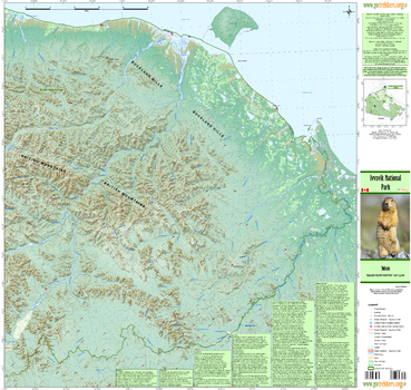
Ivvavik National Park
GoTrekkers
Ivvavik National Park
Page Size: 35.75 x 33.75 in (904 x 857 mm)
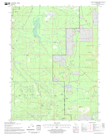
Jacks Backbone Quadrangle, California
United States Department of Agriculture Forest Service
United States Department of Agriculture Forestry Service topographical map of Jacks Backbone, Lassen National Forest, California.
Page Size: 21.75 x 27 in (552 x 686 mm)
No search results