


MapSherpa Catalog
Close-up USA, Hawaii - Published 1976
National Geographic
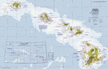
The Hawaiian Islands are a popular United States vacation site. This map details Hawaii's national and state parks, volcanoes, and points of interest, and includes information on a variety of tourist activities and events. Published in April 1976 as part of the "Close-up: U.S.A" series.
Page Size: 35.25 x 22.5 in (890 x 571 mm)
Close-up USA, Hawaii Theme - Published 1976
National Geographic
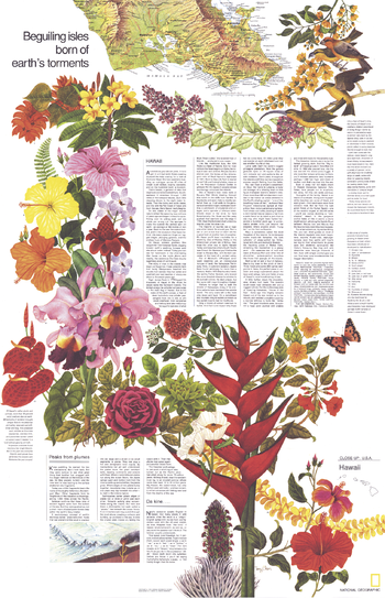
Discover the exotic beauty of the 50th state with this travel poster and map of "Hawaii: Beguiling Isles Born of Earth's Torments." Part of the "Close-up: U.S.A." series and half of a two-map set, this work was published in April 1976. Filled with interesting facts and an abundance of tourist information, this poster also features beautiful illustrations of native plants and wildlife.
Page Size: 22.75 x 35 in (573 x 889 mm)
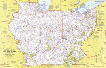
Close-up USA, Illinois, Indiana, Ohio, Kentucky - Published 1977
National Geographic
This regional map of the United States highlights the states of Illinois, Indiana, Ohio, and Kentucky. From the shores of the Great Lakes to the rolling hills of Kentucky, this region boasts unique historic attractions, including the birthplaces of Abraham Lincoln and aviation pioneers Wilbur and Orville Wright, John Glenn, and Neil Armstrong. Published in February 1977 as part of the "Close-up: U.S.A." series, with the travel poster "Illinois, Indiana, Ohio, and Kentucky."
Page Size: 35 x 22.75 in (887 x 572 mm)
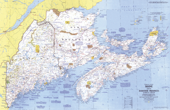
Close-up USA, Maine - Published 1975
National Geographic
This map details Maine, the most northeastern state in the United States, as well as the surrounding Canadian maritime provinces of New Brunswick, Nova Scotia, and Prince Edward Island. Includes a wealth of notes about the festivals, events, and historical sites one can visit in this scenic region. Published in March 1975 as part of the "Close-up: U.S.A." series, with a companion travel poster and an article on Nova Scotia.
Page Size: 35.25 x 22.75 in (890 x 577 mm)

Close-up USA, Maine Theme - Published 1975
National Geographic
The "Maine, with Maritime Provinces of Close-up: Canada: Sea-swept Coves Beside a Forested Realm" travel poster is half of a two-map set published in March 1975. A companion to the "Maine, with Maritime Provinces of Close-Up: Canada" map, this poster contains a wealth of information on the sites of interest, travel tips, and tourist activities to be enjoyed in this unique region.
Page Size: 23 x 35 in (579 x 889 mm)
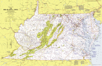
Close-up USA, Mid-Atlantic States - Published 1976
National Geographic
This map details the Mid-Atlantic United States. Explore the earliest English settlements in North America, Revolutionary War and Civil War sites, and the nation's capital. Published in October 1976 as part of the "Close-up: U.S.A." series, with the travel poster "Maryland, Virginia, Delaware, West Virginia: Beckoning Land Beside Bay and Sea" and two articles on the Potomac River.
Page Size: 35 x 22.75 in (888 x 576 mm)
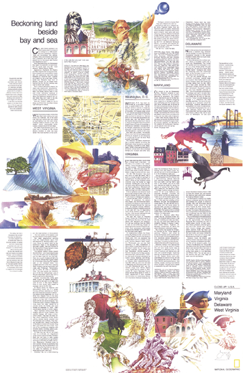
Close-up USA, Mid-Atlantic States Theme - Published 1976
National Geographic
Published in October 1976, this map/travel poster entitled "Maryland, Virginia, Delaware, West Virginia: Beckoning Land Beside Bay and Sea" is half of a two-piece set in the "Close-Up: U.S.A." series, a companion to the Mid-Atlantic States map. With an overview of the beautiful natural features and historical sites to be found in each of the four states and in Washington, D.C., this work is a wonderful guide for travelers.
Page Size: 23 x 35 in (578 x 886 mm)
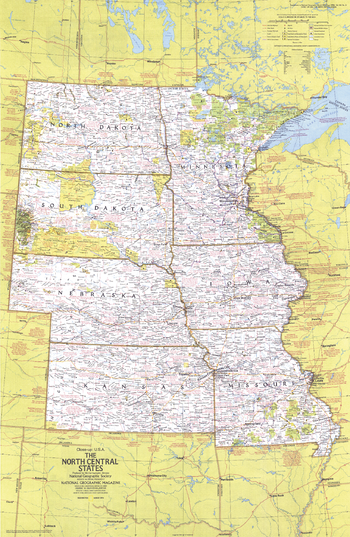
Close-up USA, North Central States - Published 1974
National Geographic
This map of the North Central United States lets you explore the nation's heartland. Features a wealth of travel and tourism information, including national and state parks, festivals, events, and historic points of interest, as well as an abundance of historical notes. Published in March 1974 as part of the "Close-up: U.S.A." series, with the travel poster "North Dakota, South Dakota, Nebraska, Kansas, Minnesota, Iowa, Missouri: Open Skies and Rolling Land."
Page Size: 22.75 x 35 in (578 x 886 mm)
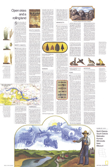
Close-up USA, North Central States Theme - Published 1974
National Geographic
The "North Dakota, South Dakota, Nebraska, Kansas, Minnesota, Iowa, Missouri: Open Skies and Rolling Land" travel poster is a companion to the map of the North Central States, published in March 1974. Part of the "Close-up: U.S.A." series, this map hightlights the diverse landmarks and landscapes to be found in the region including agricultural settings, Indian reservations, frontier forts, national forests, and scenic lakes and rivers.
Page Size: 23 x 35 in (578 x 886 mm)
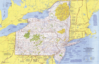
Close-up USA, Northeast - Published 1978
National Geographic
This map of the Northeast United States highlights the states of New York, New Jersey, and Pennsylvania. It details the variety of exciting travel destinations including the cities of New York City and Philadelphia, the forests and ski resorts of the Adirondacks and Catskills, and the quaint farms of Pennsylvania Dutch country. Published in January 1978 as part of the "Close-up: U.S.A." series, with the travel poster "New York, New Jersey, Pennsylvania: Glittering Cities, Lonely Wild Lands."
Page Size: 35 x 22.75 in (884 x 574 mm)

Close-up USA, Northeast Theme - Published 1978
National Geographic
Published in January 1978 with the Northeast map, the travel poster "New York, New Jersey, Pennsylvania: Glittering Cities, Lonely Wild Lands" contains detail of the cities, seashores, farms, national parks, and ski resorts vacationers can enjoy in this diverse region. These works are part of the "Close-up: U.S.A" series of maps.
Page Size: 22.75 x 34.75 in (577 x 882 mm)
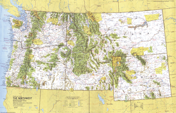
Close-up USA, Northwest - Published 1973
National Geographic
This map of the Northwest United States lets you explore the region, which contains stunning and abundant national parks and forest systems. Features a wealth of travel and tourism information as well as an abundance of historical notes. Published in March 1973 as part of the "Close-up: U.S.A." series, with the travel poster "Washington, Oregon, Idaho, Montana, Wyoming: Timber, Cattle, and the Mist from the Sea."
Page Size: 35 x 22.75 in (888 x 573 mm)
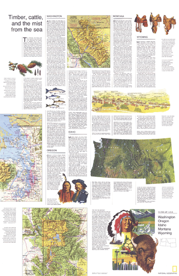
Close-up USA, Northwest Theme - Published 1973
National Geographic
Explore the diversity of the Northwest with this attractive travel map entitled "Washington, Oregon, Idaho, Montana, Wyoming: Timber, Cattle, and the Mist from the Sea." Published in March 1973 as part of the "Close-up: U.S.A." series and companion to the Northwest map, this work includes inset maps and information about the world-renowned national parks of the region and each state's points of interest and tourist attractions.
Page Size: 22.75 x 35 in (575 x 886 mm)
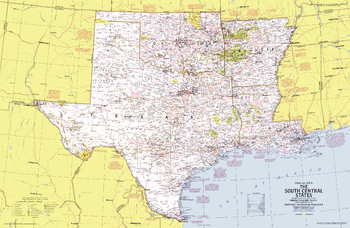
Close-up USA, South Central States - Published 1974
National Geographic
This map of the South Central United States lets you explore the region. From cattle roundups and Indian cultural centers on the plains to Cajun bayous and Mardi Gras on the Mississippi delta, the area is remarkably diverse in its geographical features and peoples. Features a wealth of travel and tourism information as well as an abundance of historical notes. Published in October 1974 as part of the "Close-up: U.S.A." series, with the travel poster "Arkansas, Oklahoma, Louisiana, Texas: Rich Land of the Southern Frontier."
Page Size: 35 x 23 in (888 x 578 mm)
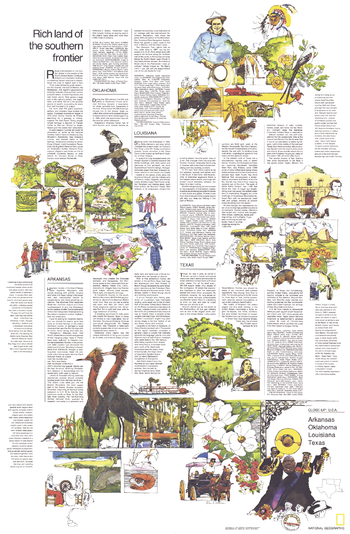
Close-up USA, South Central States Theme - Published 1974
National Geographic
Published in October 1974, this poster entitled "Arkansas, Oklahoma, Louisiana, Texas: Rich Land of the Southern Frontier" is half of a two-piece set in the "Close-Up: U.S.A." series, a companion to the South Central States map. With an overview of the beautiful and exciting vacations spots and sites to be seen in each of the four states, this work is a wonderful guide for travelers.
Page Size: 23 x 35 in (580 x 886 mm)
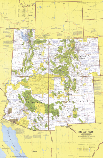
Close-up USA, Southwest - Published 1977
National Geographic
This map of the Southwest United States ranges from the breathtaking heights of the Rocky Mountains to the otherworldly Sonoran desert of southern Arizona. Published in October 1977, this map is half of a two-piece set in the "Close-up: U.S.A." series, with the travel poster "Arizona, New Mexico, Utah, Colorado: Surprise and Challenge Amid Sere Beauty."
Page Size: 23 x 34.75 in (578 x 882 mm)

Close-up USA, Southwest Theme - Published 1977
National Geographic
The "Arizona, New Mexico, Utah, Colorado: Surprise and Challenge Amid Sere Beauty" travel poster was printed in October 1977 with its companion, the Southwest map. Part of the "Close-up: U.S.A." series, this poster highlights the tourist activities, historical sites, resorts, and scenic vistas to be enjoyed in this enchanting region.
Page Size: 23 x 34.75 in (578 x 882 mm)
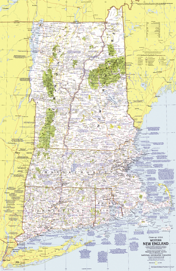
Close-up USA, Western New England - Published 1975
National Geographic
This map lets you explore the Western New England region of the United States. Includes a wealth of travel and tourism information as well as an abundance of historical notes. Published in July 1975 as part of the "Close-up: U.S.A." series, with an article on Cape Cod and the travel poster "New Hampshire, Vermont, Massachusetts, Rhode Island, Connecticut: Mountains, Seacoast, and a Living Legacy."
Page Size: 22.75 x 35 in (575 x 886 mm)

Close-up USA, Western New England Theme - Published 1975
National Geographic
The "New Hampshire, Vermont, Massachusetts, Rhode Island, Connecticut: Mountains, Seacoast, and a Living Legacy" map was printed in July 1975 with its companion, the Western New England map. Part of the "Close-up: U.S.A." series, this poster highlights the tourist activities, historical sites, resorts, and scenic vistas to be enjoyed in the region.
Page Size: 22.75 x 35 in (575 x 886 mm)
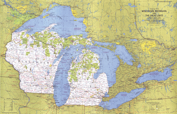
Close-up USA, Wisconsin, Michigan, and the Great Lakes - Published 1973
National Geographic
This map of the United States side of the western Great Lakes highlights the states of Wisconsin and Michigan. It details the vacation areas and sites throughout this beautiful region. Published in August 1973 as part of the "Close-up: U.S.A." series, with the travel poster "Wisconsin, Michigan, and the Great Lakes: Land Between the Waters."
Page Size: 35.25 x 22.75 in (889 x 573 mm)
No search results