XYZ Maps
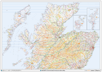
North Scotland Postcode District Wall Map (D6)
The North Scotland Postcode District Map clearly shows postcode district boundaries and associated district labels (AB1, AB2) on a comprehensive background and is perfect for determining postcode boundaries for sales territories, logistics, planning mailshots or as a regional reference guide.
Page Size: 47 x 33.25 in (1189 x 841 mm)
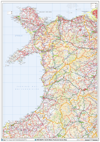
North Wales Postcode Sector Wall Map (S9)
The North Wales Postcode Sector Wall Map shows detailed postcode sector boundaries along with its associated label (LL1 1, LL1 2) on a comprehensive background and is perfect for determining postcode boundaries, for sales, logistics, planning mailshots or as a regional reference guide.
Page Size: 33.25 x 47 in (841 x 1189 mm)
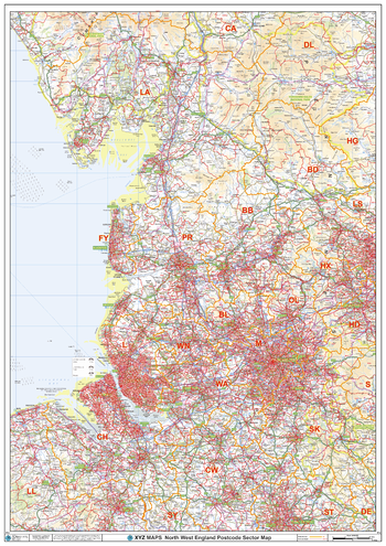
North West England Postcode Sector Wall Map (S12)
The North West England Postcode Sector Wall Map shows detailed postcode sector boundaries along with its associated label (M1 1, M1 2) on a comprehensive background and is perfect for determining postcode boundaries, for sales, logistics, planning mailshots or as a regional reference guide.
Page Size: 33.25 x 47 in (841 x 1189 mm)
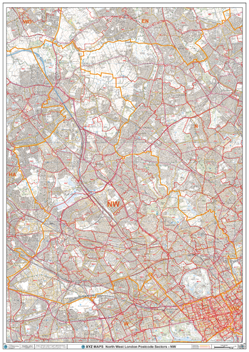
North West London - NW - Postcode Wall Map
The North West London Postcode Sector Wall Map shows detailed postcode sector boundaries (NW1 1, NW1 2) on a comprehensive background and is perfect for determining postcode boundaries for sales areas, planning mailshots and also an excellent reference for logistics. This wall map covers the whole of the NW Postcode Area.
Page Size: 33.25 x 47 in (841 x 1189 mm)
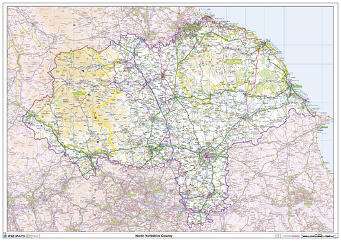
North Yorkshire County Map
This is a large ceremonial county map of North Yorkshire highlighting the county border, with the surrounding area faded out for excellent contrast. The map covers Guisborough, Harrogate, Hawes, Helmsley, Northallerton, Middlesbrough, Pickering, Scarborough, Redcar, Richmond, Thirsk and Whitby. The county map shows the latest County and Unitary Authority Boundaries, Overlaid on a Clear and Easy to Read Ordnance Survey map.
Page Size: 47 x 33.25 in (1189 x 841 mm)
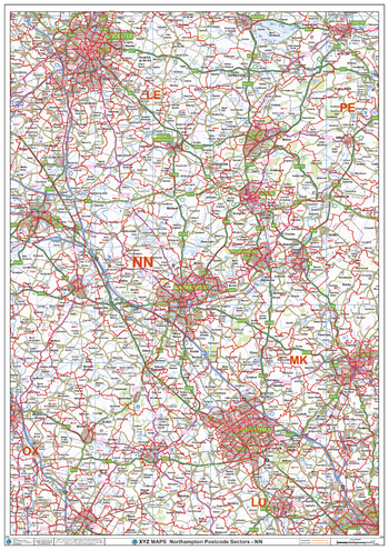
Northampton - NN - Postcode Wall Map
The Northampton Postcode Sector Wall Map shows detailed postcode sector boundaries (NN1 1, NN1 2) on a comprehensive background and is perfect for determining postcode boundaries for sales areas, planning mailshots and also an excellent reference for logistics. This wall map covers the whole of the NN Postcode Area.
Page Size: 33.25 x 47 in (841 x 1189 mm)
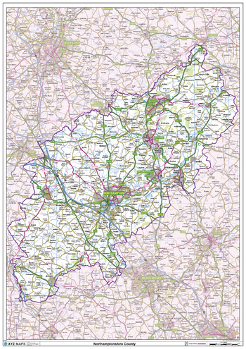
Northamptonshire County Map
This is a large ceremonial county map of Northamptonshire highlighting the county border, with the surrounding area faded out for excellent contrast. The map covers Brackley, Brixworth, Corby, Daventry, Earls Barton, Irthlingborough, Kettering, Northampton, Oundle, Rushden, Peterborough, Silverstone, Towcester and Wellingborough. The county map shows the latest County and Unitary Authority Boundaries, Overlaid on a Clear and Easy to Read Ordnance Survey map.
Page Size: 33.25 x 47 in (841 x 1189 mm)
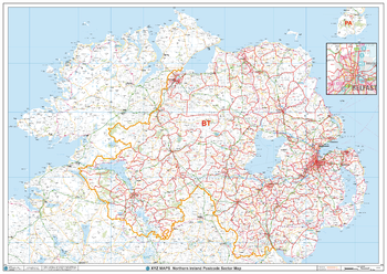
Northern Ireland Postcode Sector Wall Map (S14)
The Northern Ireland Postcode Sector Wall Map shows detailed postcode sector boundaries along with its associated label (BT1 1, BT1 2) on a comprehensive background and is perfect for determining postcode boundaries, for sales, logistics, planning mailshots or as a regional reference guide.
Page Size: 47 x 33.25 in (1189 x 841 mm)
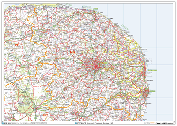
Norwich - NR - Postcode Wall Map
The Norwich Postcode Sector Wall Map shows detailed postcode sector boundaries (NR1 1, NR1 2) on a comprehensive background and is perfect for determining postcode boundaries for sales areas, planning mailshots and also an excellent reference for logistics. This wall map covers the whole of the NR Postcode Area.
Page Size: 47 x 33.25 in (1189 x 841 mm)
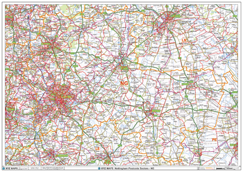
Nottingham - NG - Postcode Wall Map
The Nottingham Postcode Sector Wall Map shows detailed postcode sector boundaries (NG1 1, NG1 2) on a comprehensive background and is perfect for determining postcode boundaries for sales areas, planning mailshots and also an excellent reference for logistics. This wall map covers the whole of the NG Postcode Area.
Page Size: 47 x 33.25 in (1189 x 841 mm)
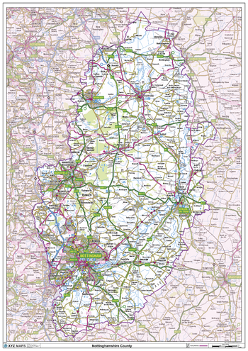
Nottinghamshire County Map
This is a large ceremonial county map of Nottinghamshire highlighting the county border, with the surrounding area faded out for excellent contrast. The map covers Beeston, Blidworth, Eastwood, Edwinstone, Mansfield, Newark on Trent, Nottingham, Retford, Southwell and Worksop. The county map shows the latest County and Unitary Authority Boundaries, Overlaid on a Clear and Easy to Read Ordnance Survey map.
Page Size: 33.25 x 47 in (841 x 1189 mm)
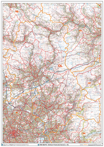
Oldham - OL - Postcode Wall Map
The Oldham Postcode Sector Wall Map shows detailed postcode sector boundaries (OL1 1, OL1 2) on a comprehensive background and is perfect for determining postcode boundaries for sales areas, planning mailshots and also an excellent reference for logistics. This wall map covers the whole of the OL Postcode Area.
Page Size: 33.25 x 47 in (841 x 1189 mm)
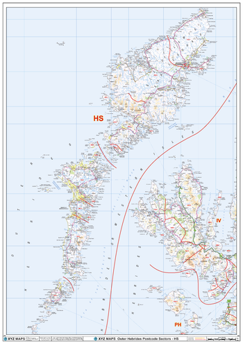
Outer Hebrides - HS - Postcode Wall Map
The Outer Hebrides Postcode Sector Wall Map shows detailed postcode sector boundaries (HS1 1, HS1 2) on a comprehensive background and is perfect for determining postcode boundaries for sales areas, planning mailshots and also an excellent reference for logistics. This wall map covers the whole of the HS Postcode Area.
Page Size: 33.25 x 47 in (841 x 1189 mm)
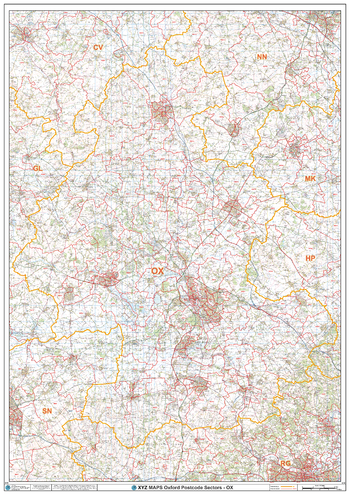
Oxford - OX - Postcode Wall Map
The Oxford Postcode Sector Wall Map shows detailed postcode sector boundaries (OX1 1, OX1 2) on a comprehensive background and is perfect for determining postcode boundaries for sales areas, planning mailshots and also an excellent reference for logistics. This wall map covers the whole of the OX Postcode Area.
Page Size: 33.25 x 47 in (841 x 1189 mm)
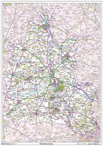
Oxfordshire County Map
This is a large ceremonial county map of Oxfordshire highlighting the county border, with the surrounding area faded out for excellent contrast. The map covers Bicester, Burford, Caversham, Chipping Norton, Dorchester, Goring-on-Thames, Henley-on-Thames, Oxford, Thame, Witney and Woodstock. The county map shows the latest County and Unitary Authority Boundaries, Overlaid on a Clear and Easy to Read Ordnance Survey map.
Page Size: 33.25 x 47 in (841 x 1189 mm)
Paisley - PA - Postcode Wall Map
The Paisley Postcode Sector Wall Map shows detailed postcode sector boundaries (PA1 1, PA1 2) on a comprehensive background and is perfect for determining postcode boundaries for sales areas, planning mailshots and also an excellent reference for logistics. This wall map covers the whole of the PA Postcode Area.
Page Size: 47 x 33.25 in (1189 x 841 mm)
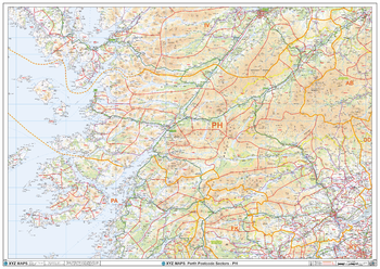
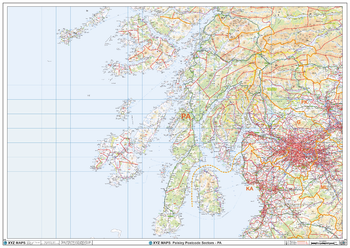
Perth - PH - Postcode Wall Map
The Perth Postcode Sector Wall Map shows detailed postcode sector boundaries (PH1 1, PH1 2) on a comprehensive background and is perfect for determining postcode boundaries for sales areas, planning mailshots and also an excellent reference for logistics. This wall map covers the whole of the PH Postcode Area.
Page Size: 47 x 33.25 in (1189 x 841 mm)
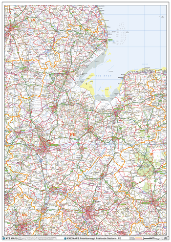
Peterborough - PE - Postcode Wall Map
The Peterborough Postcode Sector Wall Map shows detailed postcode sector boundaries (PE1 1, PE1 2) on a comprehensive background and is perfect for determining postcode boundaries for sales areas, planning mailshots and also an excellent reference for logistics. This wall map covers the whole of the PE Postcode Area.
Page Size: 33.25 x 47 in (841 x 1189 mm)
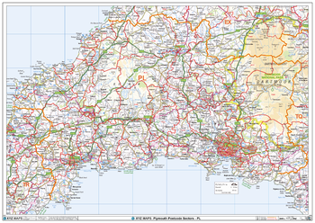
Plymouth - PL - Postcode Wall Map
The Plymouth Postcode Sector Wall Map shows detailed postcode sector boundaries (PL1 1, PL1 2) on a comprehensive background and is perfect for determining postcode boundaries for sales areas, planning mailshots and also an excellent reference for logistics. This wall map covers the whole of the PL Postcode Area.
Page Size: 47 x 33.25 in (1189 x 841 mm)
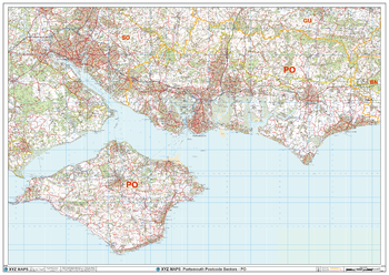
Portsmouth - PO - Postcode Wall Map
The Portsmouth Postcode Sector Wall Map shows detailed postcode sector boundaries (PO1 1, PO1 2) on a comprehensive background and is perfect for determining postcode boundaries for sales areas, planning mailshots and also an excellent reference for logistics. This wall map covers the whole of the PO Postcode Area.
Page Size: 47 x 33.25 in (1189 x 841 mm)