XYZ Maps
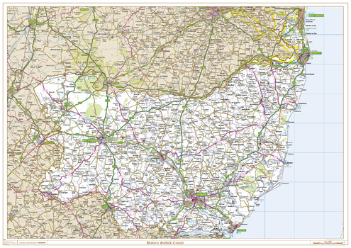
Historic Suffolk County Map
This is a historic county map of Suffolk, highlighting the traditional county border, the surrounding area is faded out with a sepia tint for excellent contrast. The historic map covers, Lowestoft, Beccles, Bury St Edmunds, Stowmarket, Sudbury, Ipswich and Felixstowe. The traditional county map has the historic county boundaries overlaid on an up to date Ordnance Survey 1:250,000 scale map.
Page Size: 47 x 33.25 in (1189 x 841 mm)
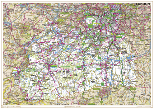
Historic Surrey County Map
This is a historic county map of Surrey, highlighting the traditional county border, the surrounding area is faded out with a sepia tint for excellent contrast. The historic map covers, Battersea, Brixton, Clapham, Croydon, Epsom, Farnham, Gatwick, Guildford, Haselmere, Kington-upon-Thames, Leatherhead, Richmond, Southwark, Wandsworth, Wimbledon and Woking. The traditional county map has the historic county boundaries overlaid on an up to date Ordnance Survey 1:250,000 scale map.
Page Size: 47 x 33.25 in (1189 x 841 mm)
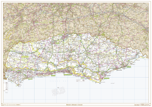
Historic Sussex County Map
This is a historic county map of Sussex, highlighting the traditional county border, the surrounding area is faded out with a sepia tint for excellent contrast. The historic map covers, East Grinstead, Crawley, Horsham, Midhurst, Chichester, Bognor Regis, Worthing, Crowborough, Uckfield, Heathfield, Hailsham, Lewes, Brighton and Hove, Newhaven, Eastbourne, Hastings, and Rye. The traditional county map has the historic county boundaries overlaid on an up to date Ordnance Survey 1:250,000 scale map.
Page Size: 47 x 33.25 in (1189 x 841 mm)
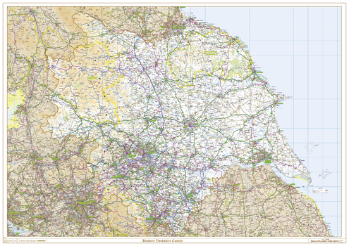
Historic Yorkshire County Map
This is a historic county map of Yorkshire, highlighting the traditional county border, the surrounding area is faded out with a sepia tint for excellent contrast. The historic map covers, Middlesbrough, Whitby, Scarborough, Bridlington, Skipton, Harrogate, York, Kingston Upon Hull, Leeds, Bradford, Huddersfield, Barnsley, Doncaster, Rotherham and Sheffield. The traditional county map has the historic county boundaries overlaid on an up to date Ordnance Survey 1:250,000 scale map.
Page Size: 47 x 33.25 in (1189 x 841 mm)
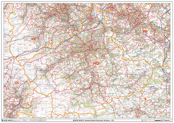
Huddersfield - HD - Postcode Wall Map
The Huddersfield Postcode Sector Wall Map shows detailed postcode sector boundaries (HD1 1, HD1 2) on a comprehensive background and is perfect for determining postcode boundaries for sales areas, planning mailshots and also an excellent reference for logistics. This wall map covers the whole of the HD Postcode Area.
Page Size: 47 x 33.25 in (1189 x 841 mm)
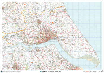
Hull - HU - Postcode Wall Map
The Hull Postcode Sector Wall Map shows detailed postcode sector boundaries (HU1 1, HU1 2) on a comprehensive background and is perfect for determining postcode boundaries for sales areas, planning mailshots and also an excellent reference for logistics. This wall map covers the whole of the HU Postcode Area.
Page Size: 47 x 33.25 in (1189 x 841 mm)
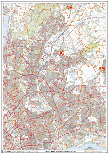
Ilford - IG - Postcode Wall Map
The Ilford Postcode Sector Wall Map shows detailed postcode sector boundaries (IG1 1, IG1 2) on a comprehensive background and is perfect for determining postcode boundaries for sales areas, planning mailshots and also an excellent reference for logistics. This wall map covers the whole of the IG Postcode Area.
Page Size: 33.25 x 47 in (841 x 1189 mm)
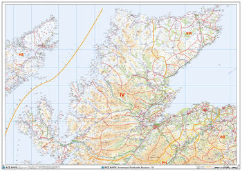
Inverness - IV - Postcode Wall Map
The Inverness Postcode Sector Wall Map shows detailed postcode sector boundaries (IV1 1, IV1 2) on a comprehensive background and is perfect for determining postcode boundaries for sales areas, planning mailshots and also an excellent reference for logistics. This wall map covers the whole of the IV Postcode Area.
Page Size: 47 x 33.25 in (1189 x 841 mm)
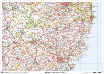
Ipswich - IP - Postcode Wall Map
The Ipswich Postcode Sector Wall Map shows detailed postcode sector boundaries (IP1 1, IP1 2) on a comprehensive background and is perfect for determining postcode boundaries for sales areas, planning mailshots and also an excellent reference for logistics. This wall map covers the whole of the IP Postcode Area.
Page Size: 47 x 33.25 in (1189 x 841 mm)
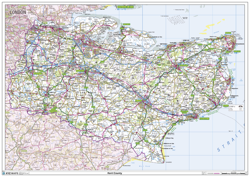
Kent County Map
This is a large ceremonial county map of Kent highlighting the county border, with the surrounding area faded out for excellent contrast. The map covers Abbots Bromley, Canterbury, Chatham, Dover, Folkestone, Greenwich, Lewisham, Maidstone, Orpington, Ramsgate, Rochester, Sevenoaks, Tunbridge Wells, Whitstable and Woolwich. The county map shows the latest County and Unitary Authority Boundaries, overlaid on a clear and easy to read Ordnance Survey map.
Page Size: 47 x 33.25 in (1189 x 841 mm)
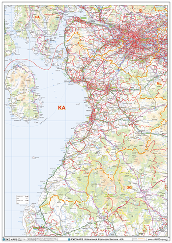
Kilmarnock - KA - Postcode Wall Map
The Kilmarnock Postcode Sector Wall Map shows detailed postcode sector boundaries (KA1 1, KA1 2) on a comprehensive background and is perfect for determining postcode boundaries for sales areas, planning mailshots and also an excellent reference for logistics. This wall map covers the whole of the KA Postcode Area.
Page Size: 33.25 x 47 in (841 x 1189 mm)
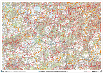
Kingston-Upon-Thames - KT - Postcode Wall Map
The Kingston-Upon-Thames Postcode Sector Wall Map shows detailed postcode sector boundaries (KT1 1, KT1 2) on a comprehensive background and is perfect for determining postcode boundaries for sales areas, planning mailshots and also an excellent reference for logistics. This wall map covers the whole of the KT Postcode Area.
Page Size: 47 x 33.25 in (1189 x 841 mm)
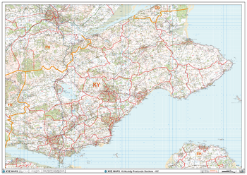
Kirkcaldy - KY - Postcode Wall Map
The Kirkcaldy Postcode Sector Wall Map shows detailed postcode sector boundaries (KY1 1, KY1 2) on a comprehensive background and is perfect for determining postcode boundaries for sales areas, planning mailshots and also an excellent reference for logistics. This wall map covers the whole of the KY Postcode Area.
Page Size: 47 x 33.25 in (1189 x 841 mm)
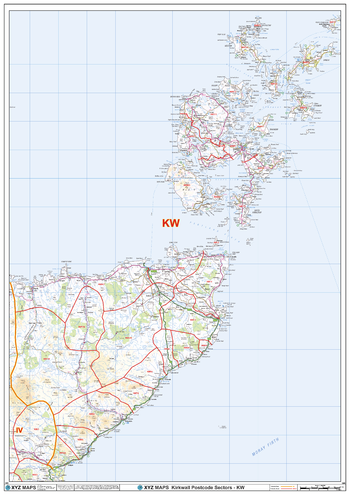
Kirkwall - KW - Postcode Wall Map
The Kirkwall Postcode Sector Wall Map shows detailed postcode sector boundaries (KW1 1, KW1 2) on a comprehensive background and is perfect for determining postcode boundaries for sales areas, planning mailshots and also an excellent reference for logistics. This wall map covers the whole of the KW Postcode Area.
Page Size: 33.25 x 47 in (841 x 1189 mm)
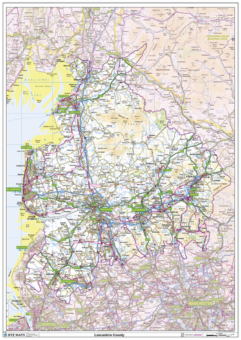
Lancashire County Map
This is a large ceremonial county map of Lancashire highlighting the county border, with the surrounding area faded out for excellent contrast. The map covers Morecombe, Lancaster, Fleetwood, Blackpool, Skelmersdale, Preston, Blackburn, Burnley and Clitheroe. The county map shows the latest County and Unitary Authority Boundaries, Overlaid on a Clear and Easy to Read Ordnance Survey map.
Page Size: 33.25 x 47 in (841 x 1189 mm)
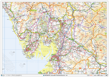
Lancaster - LA - Postcode Wall Map
The Lancaster Postcode Sector Wall Map shows detailed postcode sector boundaries (LA1 1, LA1 2) on a comprehensive background and is perfect for determining postcode boundaries for sales areas, planning mailshots and also an excellent reference for logistics. This wall map covers the whole of the LA Postcode Area.
Page Size: 47 x 33.25 in (1189 x 841 mm)
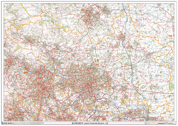
Leeds - LS - Postcode Wall Map
The Leeds Postcode Sector Wall Map shows detailed postcode sector boundaries (LS1 1, LS1 2) on a comprehensive background and is perfect for determining postcode boundaries for sales areas, planning mailshots and also an excellent reference for logistics. This wall map covers the whole of the LS Postcode Area.
Page Size: 47 x 33.25 in (1189 x 841 mm)
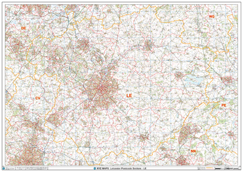
Leicester - LE - Postcode Wall Map
The Leicester Postcode Sector Wall Map shows detailed postcode sector boundaries (LE1 1, LE1 2) on a comprehensive background and is perfect for determining postcode boundaries for sales areas, planning mailshots and also an excellent reference for logistics. This wall map covers the whole of the LE Postcode Area.
Page Size: 47 x 33.25 in (1189 x 841 mm)
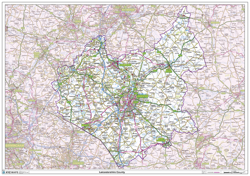
Leicestershire County Map
This is a large ceremonial county map of Leicestershire highlighting the county border, with the surrounding area faded out for excellent contrast. The map covers Ashby-de-La-Zouch, Coalville, Hinckley, Leicester, Loughborough, Lutterworth, Market Bosworth, Market Harborough and Melton Mowbray. The county map shows the latest County and Unitary Authority Boundaries, Overlaid on a Clear and Easy to Read Ordnance Survey map.
Page Size: 47 x 33.25 in (1189 x 841 mm)
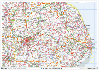
Lincoln - LN - Postcode Wall Map
The Lincoln Postcode Sector Wall Map shows detailed postcode sector boundaries (LN1 1, LN1 2) on a comprehensive background and is perfect for determining postcode boundaries for sales areas, planning mailshots and also an excellent reference for logistics. This wall map covers the whole of the LN Postcode Area.
Page Size: 47 x 33.25 in (1189 x 841 mm)