XYZ Maps
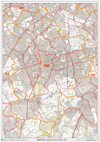
Sutton - SM - Postcode Wall Map
The Sutton Postcode Sector Wall Map shows detailed postcode sector boundaries (SM1 1, SM1 2) on a comprehensive background and is perfect for determining postcode boundaries for sales areas, planning mailshots and also an excellent reference for logistics. This wall map covers the whole of the SM Postcode Area.
Page Size: 33.25 x 47 in (841 x 1189 mm)
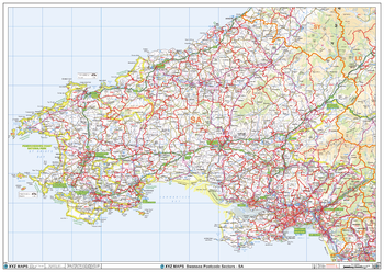
Swansea - SA - Postcode Wall Map
The Swansea Postcode Sector Wall Map shows detailed postcode sector boundaries (SA1 1, SA1 2) on a comprehensive background and is perfect for determining postcode boundaries for sales areas, planning mailshots and also an excellent reference for logistics. This wall map covers the whole of the SA Postcode Area.
Page Size: 47 x 33.25 in (1189 x 841 mm)
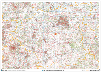
Swindon - SN - Postcode Wall Map
The Swindon Postcode Sector Wall Map shows detailed postcode sector boundaries (SN1 1, SN1 2) on a comprehensive background and is perfect for determining postcode boundaries for sales areas, planning mailshots and also an excellent reference for logistics. This wall map covers the whole of the SN Postcode Area.
Page Size: 47 x 33.25 in (1189 x 841 mm)
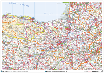
Taunton - TA - Postcode Wall Map
The Taunton Postcode Sector Wall Map shows detailed postcode sector boundaries (TA1 1, TA1 2) on a comprehensive background and is perfect for determining postcode boundaries for sales areas, planning mailshots and also an excellent reference for logistics. This wall map covers the whole of the TA Postcode Area.
Page Size: 47 x 33.25 in (1189 x 841 mm)
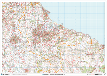
Teeside - TS - Postcode Wall Map
The Teeside Postcode Sector Wall Map shows detailed postcode sector boundaries (TS1 1, TS1 2) on a comprehensive background and is perfect for determining postcode boundaries for sales areas, planning mailshots and also an excellent reference for logistics. This wall map covers the whole of the TS Postcode Area.
Page Size: 47 x 33.25 in (1189 x 841 mm)
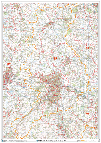
Telford - TF - Postcode Wall Map
The Telford Postcode Sector Wall Map shows detailed postcode sector boundaries (E1 1, E1 2) on a comprehensive background and is perfect for determining postcode boundaries for sales areas, planning mailshots and also an excellent reference for logistics. This wall map covers the whole of the E Postcode Area.
Page Size: 33.25 x 47 in (841 x 1189 mm)
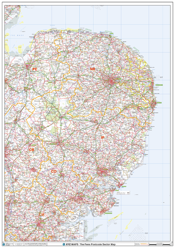
The Fens Postcode Sector Wall Map (S8)
The Fens Postcode Sector Wall Map shows detailed postcode sector boundaries along with its associated label (LL1 1, LL1 2) on a comprehensive background and is perfect for determining postcode boundaries, for sales, logistics, planning mailshots or as a regional reference guide.
Page Size: 33.25 x 47 in (841 x 1189 mm)
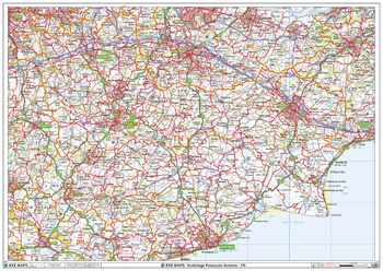
Tonbridge - TN - Postcode Wall Map
The Tonbridge Postcode Sector Wall Map shows detailed postcode sector boundaries (TN1 1, TN1 2) on a comprehensive background and is perfect for determining postcode boundaries for sales areas, planning mailshots and also an excellent reference for logistics. This wall map covers the whole of the TN Postcode Area.
Page Size: 47 x 33.25 in (1189 x 841 mm)
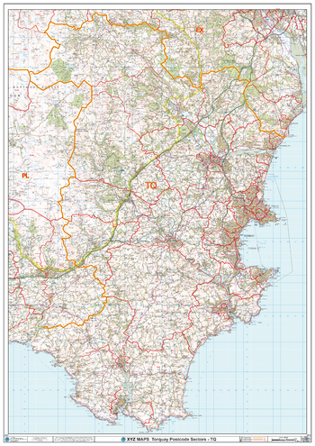
Torquay - TQ - Postcode Wall Map
The Torquay Postcode Sector Wall Map shows detailed postcode sector boundaries (TQ1 1, TQ1 2) on a comprehensive background and is perfect for determining postcode boundaries for sales areas, planning mailshots and also an excellent reference for logistics. This wall map covers the whole of the TQ Postcode Area.
Page Size: 33.25 x 47 in (841 x 1189 mm)
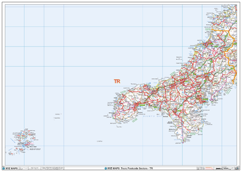
Truro - TR - Postcode Wall Map
The Truro Postcode Sector Wall Map shows detailed postcode sector boundaries (TR1 1, TR1 2) on a comprehensive background and is perfect for determining postcode boundaries for sales areas, planning mailshots and also an excellent reference for logistics. This wall map covers the whole of the TR Postcode Area.
Page Size: 47 x 33.25 in (1189 x 841 mm)
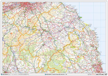
Tweed - TD - Postcode Wall Map
The Tweed Postcode Sector Wall Map shows detailed postcode sector boundaries (TD1 1, TD1 2) on a comprehensive background and is perfect for determining postcode boundaries for sales areas, planning mailshots and also an excellent reference for logistics. This wall map covers the whole of the TD Postcode Area.
Page Size: 47 x 33.25 in (1189 x 841 mm)
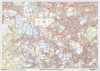
Twickenham - TW - Postcode Wall Map
The Twickenham Postcode Sector Wall Map shows detailed postcode sector boundaries (TW1 1, TW1 2) on a comprehensive background and is perfect for determining postcode boundaries for sales areas, planning mailshots and also an excellent reference for logistics. This wall map covers the whole of the TW Postcode Area.
Page Size: 47 x 33.25 in (1189 x 841 mm)
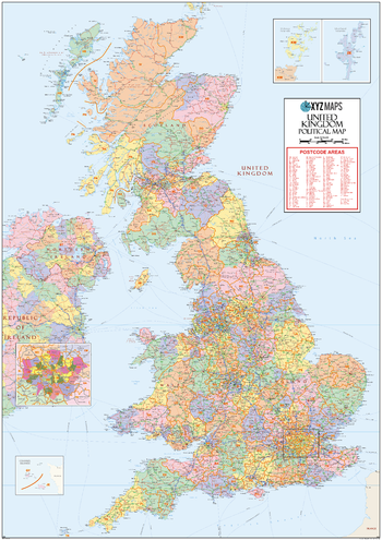
UK Political Postcode Area Large Wall Map (A2)
The UK Political Postcode Area Large Wall Map clearly shows the 124 postcode area boundaries on a comprehensive background and is perfect for determining national postcode boundaries, national planning, logistics or as a national reference guide.
Page Size: 39.5 x 55.75 in (1000 x 1414 mm)
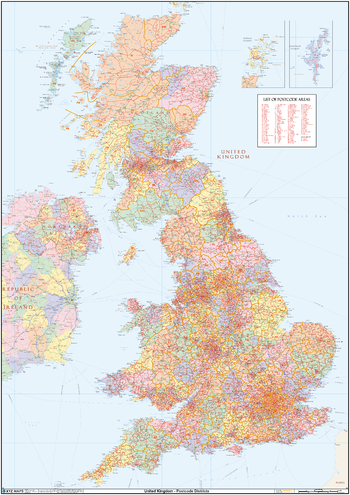
UK Political Postcode District Wall Map (D8)
This huge UK Political Postcode District Wall Map is 2A in size (1189mm x 1682mm, 4ft x 6ft). We believe it is the only single wall map to cover the United Kingdom at postcode district level. The map features a political map base showing the counties and unitary authorities in pastel colours.
Page Size: 47 x 66.25 in (1189 x 1682 mm)
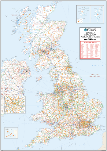
UK Roads Postcode Areas Large Wall Map (A5)
This UK Roads Postcode Areas Large Wall Map clearly shows the 124 postcode area boundaries on a comprehensive background including motorways and trunk roads and is excellent for determining national postcode boundaries, national planning, logistics or as a national reference guide.
Page Size: 39.5 x 55.75 in (1000 x 1414 mm)
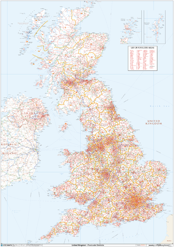
UK White Background Postcode District Wall (D11)
This huge UK white Background Postcode District Wall Map is 2A in size (1189mm x 1682mm, 4ft x 6ft). We believe it is the only single wall map to cover the United Kingdom at postcode districtlLevel. The map features a plain white map base with roads and towns.
Page Size: 47 x 66.25 in (1189 x 1682 mm)
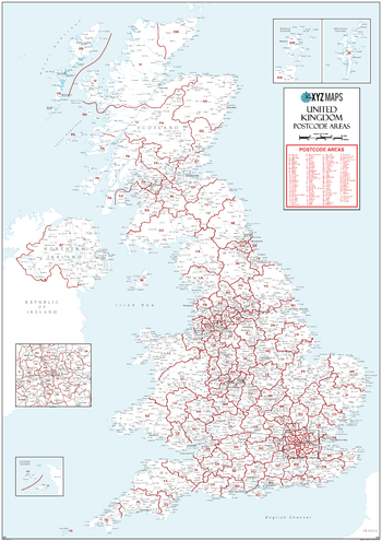
UK White Postcode Area Medium Wall Map (A4)
This UK White Postcode Area Medium Wall Map clearly shows the 124 postcode area boundaries on a white background and is perfect for determinig national postcode boundaries, national planning logistics, or as a national reference guide.
Page Size: 23.5 x 33.25 in (594 x 841 mm)
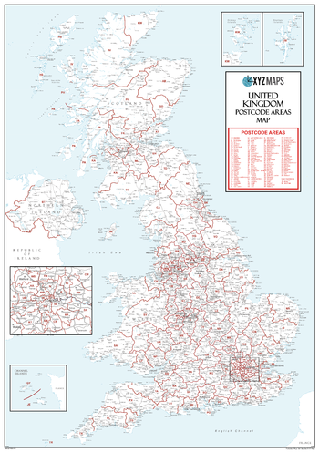
UK White Postcode Areas Large Wall Map (A3)
This UK White Postcode Areas Large Wall Map clearly shows the 124 postcode area boundaries and associated postcode labels on a white background and is perfect for determining national postcode boundaries, national planning, logistics or as a national reference guide.
Page Size: 39.5 x 55.75 in (1000 x 1414 mm)
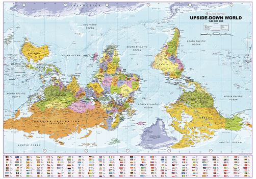
Upside Down World Political Wall Map
Wall map of the world with a twist! An alternative view of the World with this wall map with everything turned on its head raising the questioning conventional wisdom and asking which way is truly up?
Page Size: 39.25 x 27.5 in (996 x 695 mm)
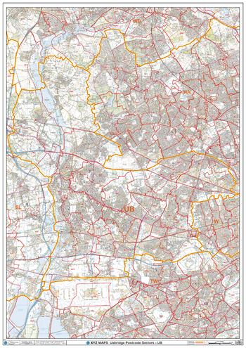
Uxbridge - UB - Postcode Wall Map
The Uxbridge Postcode Sector Wall Map shows detailed postcode sector boundaries (UB1 1, UB1 2) on a comprehensive background and is perfect for determining postcode boundaries for sales areas, planning mailshots and also an excellent reference for logistics. This wall map covers the whole of the UB Postcode Area.
Page Size: 33.25 x 47 in (841 x 1189 mm)