


The Times

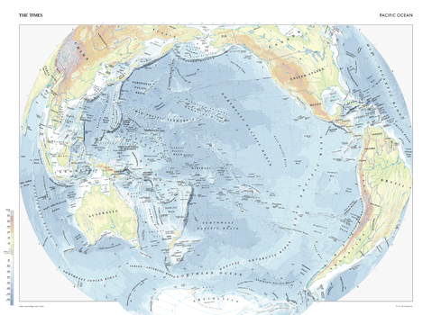
The Times Map of the Pacific Ocean
This map of the Pacific Ocean stands as a benchmark of cartographic excellence, sourced from the industry-leading Times Comprehensive Atlas of the World. Published in full colour, this map offers a comprehensive and updated view of the diverse seascapes and features that define this vast ocean. Encompassing the waters between the continents of Asia, Australia, North and South America, and more, this map provides a detailed look at the trenches, ridges and basins within the Pacific Ocean. With meticulous attention to detail, this map is an indispensable guide to the geographic intricacies and highlights of the Pacific Ocean.
Page Size: 36.5 x 26.75 in (924 x 675 mm)
The Times Map of the Pacific Ocean - Compact
This map of the Pacific Ocean stands as a benchmark of cartographic excellence, sourced from the industry-leading Times Comprehensive Atlas of the World. Published in full colour, this map offers a comprehensive and updated view of the diverse seascapes and features that define this vast ocean. Encompassing the waters between the continents of Asia, Australia, North and South America, and more, this map provides a detailed look at the trenches, ridges and basins within the Pacific Ocean. With meticulous attention to detail, this map is an indispensable guide to the geographic intricacies and highlights of the Pacific Ocean.
Page Size: 22.25 x 16.25 in (561 x 410 mm)
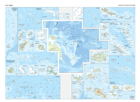
The Times Map of the Pacific Ocean Islands
This map of the Pacific Ocean Islands is a benchmark of cartographic excellence, taken from the industry leading Times Comprehensive Atlas of the World. Showing the Pacific Ocean islands in situ alongside thirty detailed inset maps of the individual Islands. Each element is carefully chosen to make the map a coherent and attractive visual guide to the Pacific Ocean Islands.
Page Size: 36.5 x 26.75 in (924 x 675 mm)
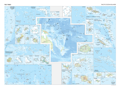
The Times Map of the Pacific Ocean Islands - Compact
This map of the Pacific Ocean Islands is a benchmark of cartographic excellence, taken from the industry leading Times Comprehensive Atlas of the World. Showing the Pacific Ocean islands in situ alongside thirty detailed inset maps of the individual Islands. Each element is carefully chosen to make the map a coherent and attractive visual guide to the Pacific Ocean Islands.
Page Size: 22.25 x 16.25 in (561 x 410 mm)

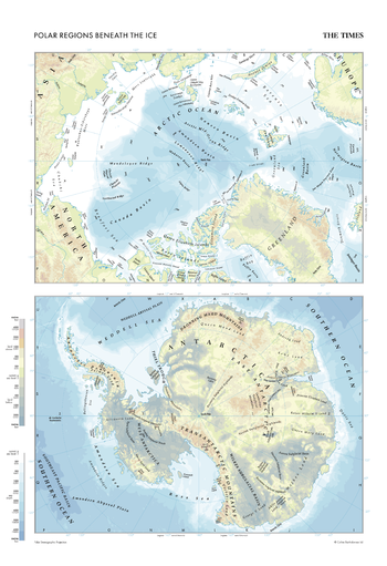
The Times Map of the Polar Regions (Beneath the Ice)
This map of the polar regions beneath the ice stands as a benchmark of cartographic excellence, sourced from the industry-leading Times Comprehensive Atlas of the World. Published in full colour, this map offers a comprehensive and updated view of the unique landscapes and features that define the areas beneath the polar ice caps. Encompassing the hidden world beneath the ice in the Arctic and Antarctic regions, this map includes prominent features such as ice formations, subglacial lakes, and geographical formations. With meticulous attention to detail, this map is an indispensable guide to the geographic intricacies and mysteries of the polar regions beneath the ice.
Page Size: 18.25 x 26.75 in (462 x 675 mm)
The Times Map of the Polar Regions (Beneath the Ice) - Compact
This map of the polar regions beneath the ice stands as a benchmark of cartographic excellence, sourced from the industry-leading Times Comprehensive Atlas of the World. Published in full colour, this map offers a comprehensive and updated view of the unique landscapes and features that define the areas beneath the polar ice caps. Encompassing the hidden world beneath the ice in the Arctic and Antarctic regions, this map includes prominent features such as ice formations, subglacial lakes, and geographical formations. With meticulous attention to detail, this map is an indispensable guide to the geographic intricacies and mysteries of the polar regions beneath the ice.
Page Size: 11.25 x 16.25 in (281 x 410 mm)
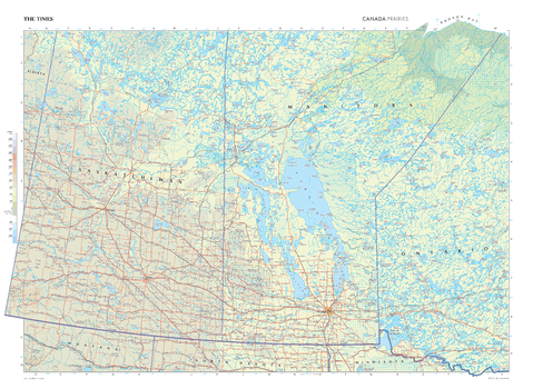
The Times Map of the Prairies (Canada)
This map of the Canadian Prairies stands as a benchmark of cartographic excellence, sourced from the industry-leading Times Comprehensive Atlas of the World. Published in full colour, this map offers a comprehensive and updated view of the diverse landscapes that are found in this region. Encompassing provinces such as Manitoba, Saskatchewan, and parts on Ontario this map includes prominent features such as Lake Winnipeg, the vast prairie landscapes, Winnipeg city, and key landmarks. With meticulous attention to detail, this map is an indispensable guide to the geographic intricacies of the Canadian Prairies.
Page Size: 36.5 x 26.75 in (924 x 675 mm)
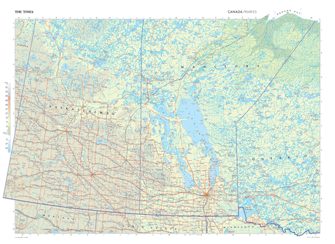
The Times Map of the Prairies (Canada) - Compact
This map of the Canadian Prairies stands as a benchmark of cartographic excellence, sourced from the industry-leading Times Comprehensive Atlas of the World. Published in full colour, this map offers a comprehensive and updated view of the diverse landscapes that are found in this region. Encompassing provinces such as Manitoba, Saskatchewan, and parts on Ontario this map includes prominent features such as Lake Winnipeg, the vast prairie landscapes, Winnipeg city, and key landmarks. With meticulous attention to detail, this map is an indispensable guide to the geographic intricacies of the Canadian Prairies.
Page Size: 22.25 x 16.25 in (561 x 410 mm)
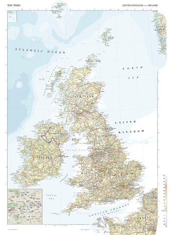
The Times Map of the United Kingdom and Ireland
This map of United Kingdom and Ireland is a benchmark of cartographic excellence, taken from the industry leading Times Comprehensive Atlas of the World. There is a high level of detail packed into the map, yet the positioning of every element is carefully chosen to make the map coherent and attractive. Capital cities of London, Edinburgh, Cardiff, Dublin and Belfast are clearly identifiable, as are additional major cities including Birmingham, Glasgow, and Manchester. Supplementary mapping shows the north of France, and an inset map provides a detailed road map of London. Each element is carefully chosen to make the map a coherent and attractive visual guide to the United Kingdom and Ireland.
Page Size: 26.75 x 36.5 in (675 x 924 mm)

The Times Map of the United Kingdom and Ireland - Compact
This map of United Kingdom and Ireland is a benchmark of cartographic excellence, taken from the industry leading Times Comprehensive Atlas of the World. There is a high level of detail packed into the map, yet the positioning of every element is carefully chosen to make the map coherent and attractive. Capital cities of London, Edinburgh, Cardiff, Dublin and Belfast are clearly identifiable, as are additional major cities including Birmingham, Glasgow, and Manchester. Supplementary mapping shows the north of France, and an inset map provides a detailed road map of London. Each element is carefully chosen to make the map a coherent and attractive visual guide to the United Kingdom and Ireland.
Page Size: 16.25 x 22.25 in (410 x 561 mm)

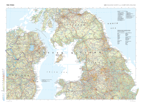
The Times Map of the United Kingdom: England (North) and Northern Ireland
This map of northern England and Northern Ireland stands as a benchmark of cartographic excellence, sourced from the industry-leading Times Comprehensive Atlas of the World. Published in full colour, this map offers a comprehensive and updated view of the north of England from Leicester and up into the Scottish borders, with additional coverage of Wales, alongside full coverage of Northern Ireland, and additional coverage of Ireland. Prominent features such as the picturesque Lake District and Peak District, the rugged coastlines of Northern Ireland, and key cities such as Manchester and Belfast are clearly identifiable. With meticulous attention to detail, this map is an indispensable guide to the geographic intricacies of northern England and Northern Ireland.
Page Size: 36.5 x 26.75 in (924 x 675 mm)
The Times Map of the United Kingdom: England (North) and Northern Ireland - Compact
This map of northern England and Northern Ireland stands as a benchmark of cartographic excellence, sourced from the industry-leading Times Comprehensive Atlas of the World. Published in full colour, this map offers a comprehensive and updated view of the north of England from Leicester and up into the Scottish borders, with additional coverage of Wales, alongside full coverage of Northern Ireland, and additional coverage of Ireland. Prominent features such as the picturesque Lake District and Peak District, the rugged coastlines of Northern Ireland, and key cities such as Manchester and Belfast are clearly identifiable. With meticulous attention to detail, this map is an indispensable guide to the geographic intricacies of northern England and Northern Ireland.
Page Size: 22.25 x 16.25 in (561 x 410 mm)
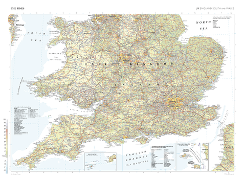
The Times Map of the United Kingdom: England (South) and Wales
This map of South England and Wales stands as a benchmark of cartographic excellence, sourced from the industry-leading Times Comprehensive Atlas of the World. Published in full colour, extending from Cornwall to Sheffield, Norfolk to Pembrokeshire, this map offers a comprehensive and updated view of the landscapes that feature in this region. Notably, the map includes insets featuring the Channel Islands and the Isles of Scilly, adding an extra layer of detail to these regions. With meticulous attention to detail, this map is an indispensable guide to the geographic intricacies of South England and Wales.
Page Size: 36.5 x 26.75 in (924 x 675 mm)
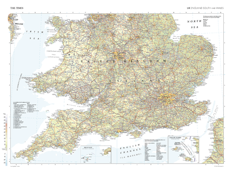
The Times Map of the United Kingdom: England (South) and Wales - Compact
This map of South England and Wales stands as a benchmark of cartographic excellence, sourced from the industry-leading Times Comprehensive Atlas of the World. Published in full colour, extending from Cornwall to Sheffield, Norfolk to Pembrokeshire, this map offers a comprehensive and updated view of the landscapes that feature in this region. Notably, the map includes insets featuring the Channel Islands and the Isles of Scilly, adding an extra layer of detail to these regions. With meticulous attention to detail, this map is an indispensable guide to the geographic intricacies of South England and Wales.
Page Size: 22.25 x 16.25 in (561 x 410 mm)
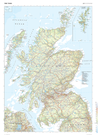
The Times Map of the United Kingdom: Scotland
This map of Scotland stands as a benchmark of cartographic excellence, sourced from the industry-leading Times Comprehensive Atlas of the World. Published in full colour, this map offers a comprehensive and updated view of the diverse landscapes that characterise this nation. Prominent features such as lochs, munros and island groups are easily identifiable, as are urban areas including the historic cities of Edinburgh and Glasgow. There is also additional coverage of the North of England and Northern Ireland, and inset maps of the Shetlands Islands and St Kilda. With meticulous attention to detail, this map is an indispensable guide to the geographic intricacies of Scotland.
Page Size: 26.75 x 36.5 in (675 x 924 mm)
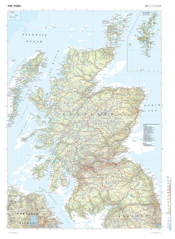
The Times Map of the United Kingdom: Scotland - Compact
This map of Scotland stands as a benchmark of cartographic excellence, sourced from the industry-leading Times Comprehensive Atlas of the World. Published in full colour, this map offers a comprehensive and updated view of the diverse landscapes that characterise this nation. Prominent features such as lochs, munros and island groups are easily identifiable, as are urban areas including the historic cities of Edinburgh and Glasgow. There is also additional coverage of the North of England and Northern Ireland, and inset maps of the Shetlands Islands and St Kilda. With meticulous attention to detail, this map is an indispensable guide to the geographic intricacies of Scotland.
Page Size: 16.25 x 22.25 in (410 x 561 mm)
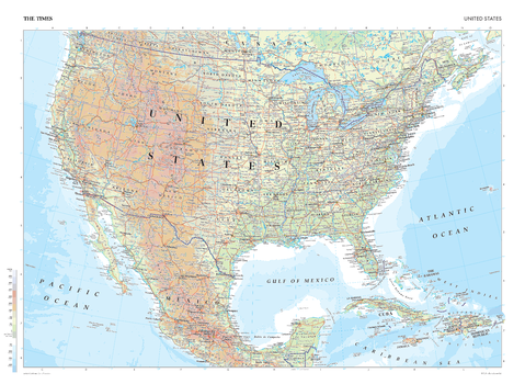
The Times Map of the United States
This map of the United States is a benchmark of cartographic excellence, taken from the industry leading Times Comprehensive Atlas of the World. There is a high level of detail packed into the map, yet the positioning of every element is carefully chosen to make the map coherent and attractive. Major cities such as New York City, Los Angeles, Chicago and Houston are easily identifiable, as is the capital, Washington D.C. International borders are clearly marked as are state borders. Geographical features including the Rocky Mountain range and major lakes are also shown. Each element is carefully chosen to make the map a coherent and attractive visual guide to the United States.
Page Size: 36.5 x 26.75 in (924 x 675 mm)
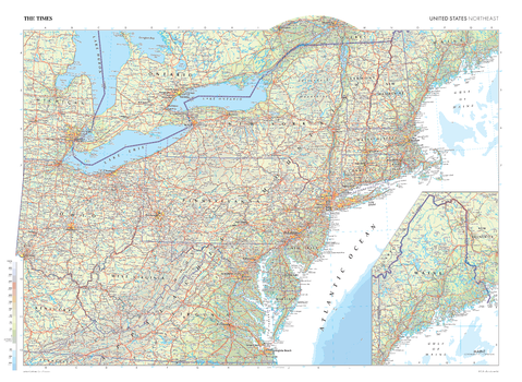
The Times Map of the United States (Northeast)
This map of the US Northeast stands as a benchmark of cartographic excellence, sourced from the industry-leading Times Comprehensive Atlas of the World. Published in full colour, this map offers a comprehensive and updated view of the diverse landscapes and cultures that define this region. Encompassing states such as New York, Massachusetts, Pennsylvania, and more, this map includes prominent features such as the Appalachian Mountains, historic cities of New York City, Washington and Philadelphia. It also has an additional scale inset map of Maine to show the state in its entirety. With meticulous attention to detail, this map is an indispensable guide to the geographic intricacies of Northeast US.
Page Size: 36.5 x 26.75 in (924 x 675 mm)

The Times Map of the United States (Northeast) - Compact
This map of the US Northeast stands as a benchmark of cartographic excellence, sourced from the industry-leading Times Comprehensive Atlas of the World. Published in full colour, this map offers a comprehensive and updated view of the diverse landscapes and cultures that define this region. Encompassing states such as New York, Massachusetts, Pennsylvania, and more, this map includes prominent features such as the Appalachian Mountains, historic cities of New York City, Washington and Philadelphia. It also has an additional scale inset map of Maine to show the state in its entirety. With meticulous attention to detail, this map is an indispensable guide to the geographic intricacies of Northeast US.
Page Size: 22.25 x 16.25 in (561 x 410 mm)
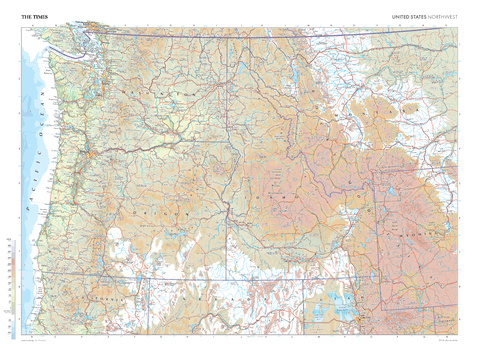
The Times Map of the United States (Northwest)
This map of the US Northwest stands as a benchmark of cartographic excellence, sourced from the industry-leading Times Comprehensive Atlas of the World. Published in full colour, this map offers a comprehensive and updated view of the landscapes that are found in this region. Encompassing states such as Washington, Montana, Oregon, Idaho, and more, this map includes prominent features such as the Pacific Ocean coastline, Rocky Mountains, and iconic cities including: Seattle, Portland, and Salt Lake City. With meticulous attention to detail, this map is an indispensable guide to the geographic intricacies of the Northwest US.
Page Size: 36.5 x 26.75 in (924 x 675 mm)