National Geographic
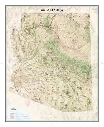
Arizona
The Arizona State Wall Map, part of our growing series of State Wall Maps. Map depicts Arizona's diverse terrain and vegetation. Contains hundreds of place names and precise locations of cities, major roadways and railways, airports, federal and state parks and protected areas, mountain ranges and prominent peaks, military installations, major lakes, rivers and reservoirs, and other geographic features.
Page Size: 34.75 x 42.25 in (878 x 1069 mm)
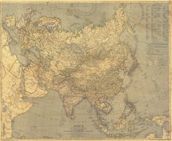
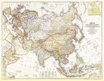
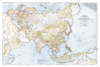
Asia - Published 1933
Collectors will treasure the intricate detail of this ambitious map of Asia. Printed in December 1933 with the article "Afghanistan Makes Haste Slowly," this work features an inset with the names of countries in English and the national language.
Page Size: 37.5 x 30.75 in (950 x 778 mm)
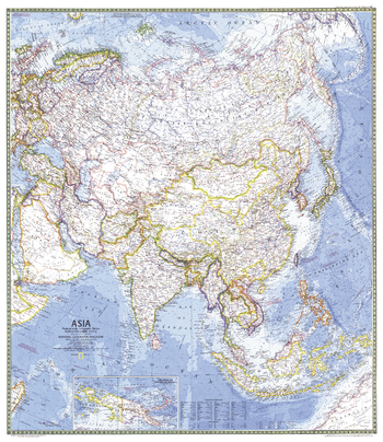
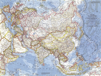
Asia - Published 1971
This vibrant and detailed map of Asia is presented in classic National Geographic style. Of particular note is the attention paid to the oceans, with colorful shading denoting depth and details of currents and prevailing winds. Published in March 1971 to accompany "The Peoples of Mainland Southeast Asia" map and the article "Pagan, on the Road to Mandalay."
Page Size: 32.5 x 37.5 in (824 x 952 mm)
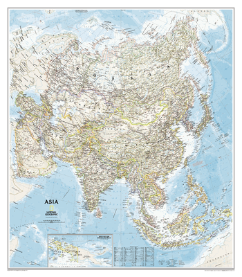
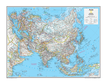
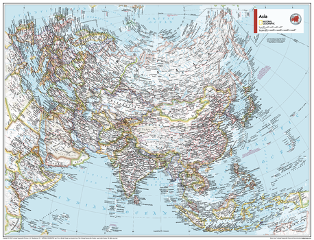
Asia Classic
Detailed National Geographic cartography includes country boundaries, place names, bodies of water, and more for the entire Asian continent.
Page Size: 33.25 x 38 in (845 x 965 mm)
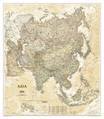
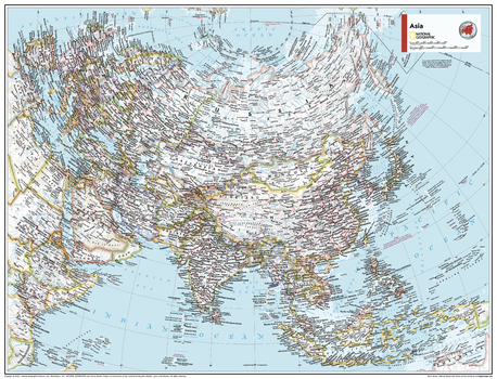
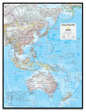
Asia Executive
Detailed National Geographic cartography includes country boundaries, place names, bodies of water, and more for the entire Asian continent.
Page Size: 33.25 x 38 in (845 x 965 mm)
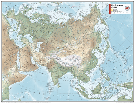
Asia Physical - Atlas of the World, 10th Edition
null
Page Size: 28 x 22 in (711 x 559 mm)

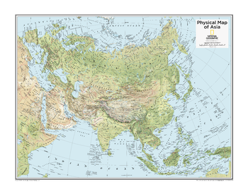
Asia Physical - Atlas of the World, 11th Edition
This map of physical geography can fit in any space. Showcasing Asia in stunning detail with state-of-the-art cartographic techniques delivering accuracy and exceptional quality, the innovative and engaging design makes the content easily accessible and user-friendly.
Ideal for classrooms with an emphasis on teaching geography or environmental themes. Physical wall maps give your students a genuine feel for how our world appears.
This physical map of Asia uses a bright, easy to read color palette featuring blue oceans and stunning shaded relief that has been featured on National Geographic wall maps for over 75 years. Drawn in the Two-Point Equidistant projection, this map ensures that all points are at proportionally correct distances from two points chosen by the cartographer.
Names of geographic features such as international boundaries, cities, rivers and lakes are carefully placed on the map to maintain legibility.
This map is found in National Geographic's 11th Edition World Atlas and is now available as a stand alone product.
Page Size: 31.5 x 24 in (798 x 610 mm)
Asia Physical - Atlas of the World, 11th Edition - Compact
This map of physical geography can fit in any space. Showcasing Asia in stunning detail with state-of-the-art cartographic techniques delivering accuracy and exceptional quality, the innovative and engaging design makes the content easily accessible and user-friendly.
Ideal for classrooms with an emphasis on teaching geography or environmental themes. Physical wall maps give your students a genuine feel for how our world appears.
This physical map of Asia uses a bright, easy to read color palette featuring blue oceans and stunning shaded relief that has been featured on National Geographic wall maps for over 75 years. Drawn in the Two-Point Equidistant projection, this map ensures that all points are at proportionally correct distances from two points chosen by the cartographer.
Names of geographic features such as international boundaries, cities, rivers and lakes are carefully placed on the map to maintain legibility.
This map is found in National Geographic's 11th Edition World Atlas and is now available as a stand alone product.
Page Size: 21.5 x 16.25 in (540 x 413 mm)
Asia Political - Atlas of the World, 10th Edition
null
Page Size: 28 x 22 in (711 x 559 mm)
Asia Political - Atlas of the World, 11th Edition
This map of political features can fit in any space. Showcasing Asia in stunning detail with state-of-the-art cartographic techniques delivering accuracy and exceptional quality, the innovative and engaging design makes the content easily accessible and user-friendly.
Ideal for classrooms with an emphasis on teaching geography or environmental themes. The inclusion of physical features to this wall map gives your students a genuine feel for how Asia appears.
This political map of Asia uses a bright, easy to read color palette featuring blue oceans and stunning shaded relief that has been featured on National Geographic wall maps for over 75 years. Drawn in the Two-Point Equidistant projection, this map ensures that all points are at proportionally correct distances from two points chosen by the cartographer.
Names of geographic features such as international boundaries, cities, rivers and lakes are carefully placed on the map to maintain legibility.
This map is found in National Geographic's 11th Edition World Atlas and is now available as a stand alone product.
Page Size: 31.5 x 24 in (798 x 610 mm)
Asia Political - Atlas of the World, 11th Edition - Compact
This map of political features can fit in any space. Showcasing Asia in stunning detail with state-of-the-art cartographic techniques delivering accuracy and exceptional quality, the innovative and engaging design makes the content easily accessible and user-friendly.
Ideal for classrooms with an emphasis on teaching geography or environmental themes. The inclusion of physical features to this wall map gives your students a genuine feel for how Asia appears.
This political map of Asia uses a bright, easy to read color palette featuring blue oceans and stunning shaded relief that has been featured on National Geographic wall maps for over 75 years. Drawn in the Two-Point Equidistant projection, this map ensures that all points are at proportionally correct distances from two points chosen by the cartographer.
Names of geographic features such as international boundaries, cities, rivers and lakes are carefully placed on the map to maintain legibility.
This map is found in National Geographic's 11th Edition World Atlas and is now available as a stand alone product.
Page Size: 21.5 x 16.25 in (540 x 413 mm)
Asia and Adjacent Areas - Published 1951
This detailed map of Asia and adjacent areas accompanied two articles in National Geographic Magazine in March of 1951: "Yankee Roams the Orient" and "The Caves of the Thousand Buddhas." Published during the Cold War between the US and the USSR, and shortly after China had annexed Tibet, this map offers a peek into Asia's past.
Page Size: 37 x 29 in (934 x 734 mm)
Asia and Adjacent Areas - Published 1959
This map, displaying the entire Asian continent, features the brilliant color and magnificently detailed cartography for which National Geographic is known. Contains notes including information on the boundaries between Asia and Europe, and Asia and Africa. Published in December 1959.
Page Size: 25 x 19 in (633 x 478 mm)
Asia, and Adjacent Areas - Published 1942
Battles were raging in Asia, Europe, and Africa at the time of this map's publication in December 1943. International boundaries on this map are as of September 1, 1939, the day Germany invaded Poland.
Page Size: 40.5 x 27.25 in (1029 x 688 mm)
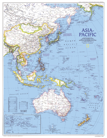
Asia-Pacific - Published 1989
This vibrant map of the Asia-Pacific region provides detail of eastern Asia, Australia and New Zealand as well as the thousands of islands in the Pacific. Published in November 1989, the Asia-Pacific map accompanied the "Western Pacific Rim" map and four articles on the region including "Hanoi: The Capital Today."
Page Size: 19.75 x 25.25 in (497 x 640 mm)
Asia-Pacific - Atlas of the World, 10th Edition
null
Page Size: 20 x 26 in (508 x 660 mm)
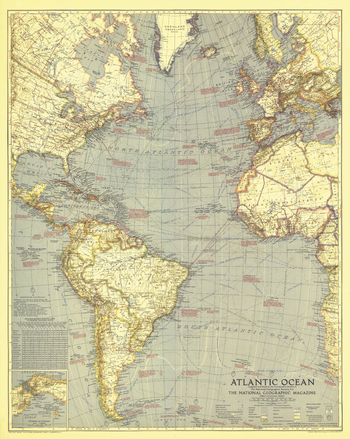
Atlantic Ocean - Published 1939
An ambitious work for its time, this beautiful map of the Atlantic Ocean was published in July 1939 when ocean bathymetry was in its infancy. Loaded with a variety of geographical and historical information this map is a splendid addition to any map collection.
Page Size: 24.75 x 31 in (626 x 784 mm)
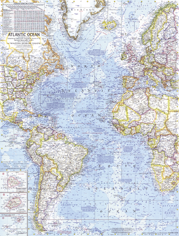
Atlantic Ocean - Published 1941
Published in September 1941, this map paints a striking portrait of the Atlantic Ocean on the verge of the US involvement in World War II. Naval bases, dates and locations of war-time events, time zone boundaries, shipping routes and air travel distances, as well as wind, current, and storm information, make this map a unique window into the turbulent times and the desire for a greater understanding of the Atlantic and its significance for travel, trade, and national security.
Page Size: 25.25 x 31.25 in (640 x 792 mm)
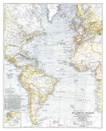
Atlantic Ocean - Published 1955
This Atlantic Ocean map features the brilliant color and magnificently detailed cartography for which National Geographic is known. Includes ocean coastlines, bathymetry, an abundance of historical notes, and an inset of submarine topography. Published in December 1955.
Page Size: 28 x 39.5 in (710 x 1000 mm)
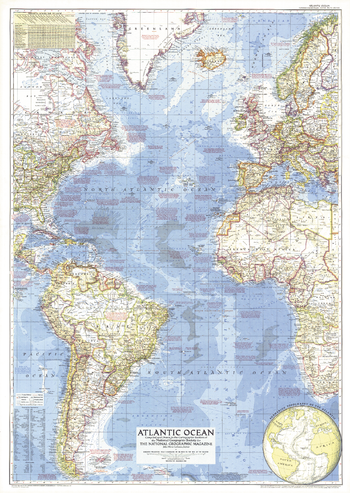
Atlantic Ocean - Published 1968
This detailed map of the Atlantic Ocean is complete with ocean bathymetry, notes on ocean currents, winds and physical features. Also contains a wealth of historical notes. Published in June 1968 to accompany the "Atlantic Ocean Floor" map. Similar in style to ocean maps of the Pacific (1969) and Arctic (1971).
Page Size: 19 x 25 in (481 x 632 mm)