MapSherpa
California Counties Map - Extra Large
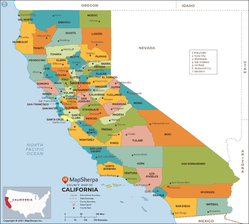
This map has been created exclusively for MapSherpa, and designed for reference or business use. Clear and clean colors & fonts matched with cartographic research makes this map of California Counties Map easily readable and useful. The map shows the 58 counties of California and their borders across the Golden State.
Page Size: 60 x 54 in (1524 x 1372 mm)

California Counties Map - Large
This map has been created exclusively for MapSherpa, and designed for reference or business use. Clear and clean colors & fonts matched with cartographic research makes this map of California Counties Map easily readable and useful. The map shows the 58 counties of California and their borders across the Golden State.
Page Size: 48 x 43.25 in (1219 x 1097 mm)

California Counties Map - Standard
This map has been created exclusively for MapSherpa, and designed for reference or business use. Clear and clean colors & fonts matched with cartographic research makes this map of California Counties Map easily readable and useful. The map shows the 58 counties of California and their borders across the Golden State.
Page Size: 36 x 32.5 in (914 x 823 mm)
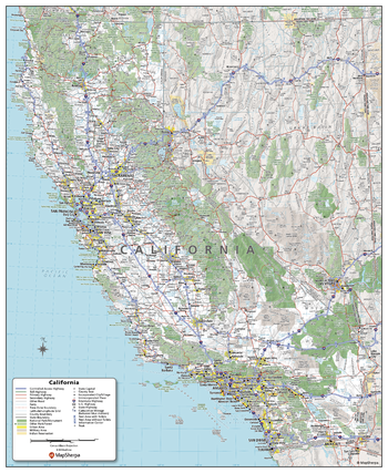
California State Wall Map - Compact
This detailed wall map of California is perfect for both educational and business purposes. The easy-to-read map features vibrant colors and clear labeling of cities, counties, highways, and geographical features. All national and state highways that connect the state are all clearly labelled on the map, while the legend notes the different road and land use classifications such as urban, park, military, and many more. The boundaries of each county in the state are defined and named clearly. Whether you are a student, teacher, business person or geography enthusiast, this map is a valuable addition to any space.
Page Size: 16 x 19.5 in (406 x 495 mm)

California State Wall Map - Extra Large
This detailed wall map of California is perfect for both educational and business purposes. The easy-to-read map features vibrant colors and clear labeling of cities, counties, highways, and geographical features. All national and state highways that connect the state are all clearly labelled on the map, while the legend notes the different road and land use classifications such as urban, park, military, and many more. The boundaries of each county in the state are defined and named clearly. Whether you are a student, teacher, business person or geography enthusiast, this map is a valuable addition to any space.
Page Size: 45 x 60 in (1143 x 1524 mm)
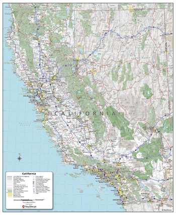
California State Wall Map - Large
This detailed wall map of California is perfect for both educational and business purposes. The easy-to-read map features vibrant colors and clear labeling of cities, counties, highways, and geographical features. All national and state highways that connect the state are all clearly labelled on the map, while the legend notes the different road and land use classifications such as urban, park, military, and many more. The boundaries of each county in the state are defined and named clearly. Whether you are a student, teacher, business person or geography enthusiast, this map is a valuable addition to any space.
Page Size: 36 x 48 in (914 x 1219 mm)
California State Wall Map - Poster
This detailed wall map of California is perfect for both educational and business purposes. The easy-to-read map features vibrant colors and clear labeling of cities, counties, highways, and geographical features. All national and state highways that connect the state are all clearly labelled on the map, while the legend notes the different road and land use classifications such as urban, park, military, and many more. The boundaries of each county in the state are defined and named clearly. Whether you are a student, teacher, business person or geography enthusiast, this map is a valuable addition to any space.
Page Size: 27 x 33 in (686 x 838 mm)
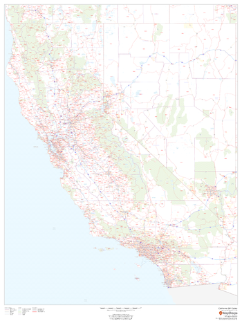
California ZIP Code Map
This map of California shows ZIP codes overlaid on a road map. Base map features include county boundaries, major road network features, and state and national parks and conservation areas.
Page Size: 36 x 48 in (914 x 1219 mm)

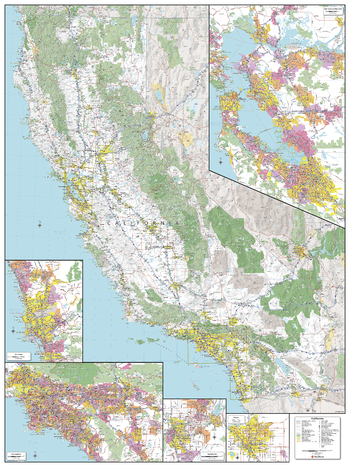
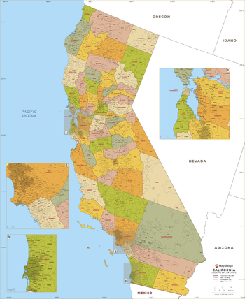
California ZIP Code Map with Counties - Extra Large
This map has been created exclusively for MapSherpa, and designed for business or reference use. Clear and clean colors & fonts matched with cartographic research makes this California Zip Code Map with Counties easily readable and useful. The map shows the 58 counties of California and the borders of the over 1,700 zip codes across the Golden State.
Page Size: 60 x 73.5 in (1524 x 1865 mm)
California ZIP Code Map with Counties - Large
This map has been created exclusively for MapSherpa, and designed for business or reference use. Clear and clean colors & fonts matched with cartographic research makes this California Zip Code Map with Counties easily readable and useful. The map shows the 58 counties of California and the borders of the over 1,700 zip codes across the Golden State.
Page Size: 48 x 58.75 in (1219 x 1492 mm)

California ZIP Code Map with Counties - Standard
This map has been created exclusively for MapSherpa, and designed for business or reference use. Clear and clean colors & fonts matched with cartographic research makes this California Zip Code Map with Counties easily readable and useful. The map shows the 58 counties of California and the borders of the over 1,700 zip codes across the Golden State.
Page Size: 36 x 44.25 in (914 x 1119 mm)
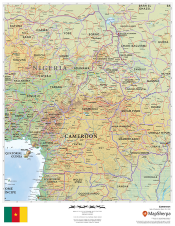
Cameroon
This beautiful map shows physical and political features for Cameroon and surrounding areas. Relief shading and the use of different colours by height above sea level are both informative and attractive.
Page Size: 17 x 22 in (432 x 559 mm)
Canada Explorer
This versatile product allows you to get a topographic map of anywhere in Canada. It has been designed so you can create a map for your next excursion.This product has been designed to make custom topographic maps suitable for short hikes to week long back-country adventures and anything in between. Back-country roads and trails are featured prominently on this map along with key points of interest such as campsites, trailheads, and landmarks. Also included are traditional topographic features such as elevation contours, landforms, lakes, and rivers along with roads, rails, trails, and park boundaries.The details of this map make it ideal to plan an excursion and take it with you. Invaluable for outdoor recreation activities such as camping, hunting, fishing, hiking, and mountain biking.
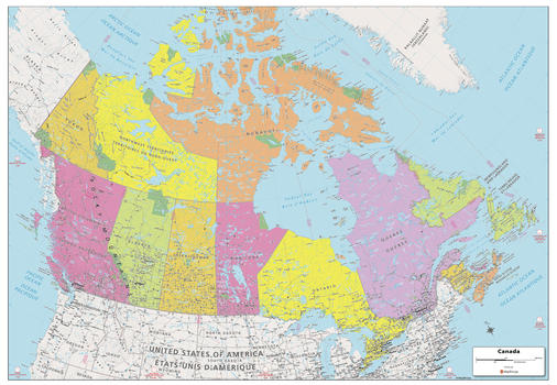
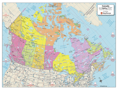
Canada Political Map
Explore the vastness of Canada with this map created specifically for MapSherpa. From sea to sea, this Canadian Political Map displays the ten provinces and three territories that make up the country. Stretching from the Arctic in the north to both the Atlantic and Pacific Oceans, this map prominently shows; Province capitals, primary cities & towns, major national parks, primary water features, mountain ranges and all time zones. With multiple sizes available, this is the perfect reference map for home, office, or school use.
Page Size: 39 x 27 in (991 x 686 mm)
Canada Political Map - Compact
Explore the vastness of Canada with this map created specifically for MapSherpa. From sea to sea, this Canadian Political Map displays the ten provinces and three territories that make up the country. Stretching from the Arctic in the north to both the Atlantic and Pacific Oceans, this map prominently shows; Province capitals, primary cities & towns, major national parks, primary water features, mountain ranges and all time zones. With multiple sizes available, this is the perfect reference map for home, office, or school use.
Page Size: 21 x 16 in (533 x 406 mm)
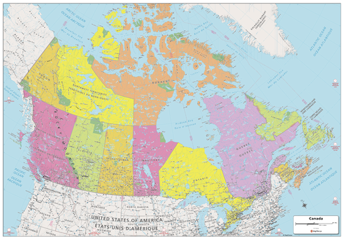
Canada Political Map - Extra Large
Explore the vastness of Canada with this map created specifically for MapSherpa. From sea to sea, this Canadian Political Map displays the ten provinces and three territories that make up the country. Stretching from the Arctic in the north to both the Atlantic and Pacific Oceans, this map prominently shows; Province capitals, primary cities & towns, major national parks, primary water features, mountain ranges and all time zones. With multiple sizes available, this is the perfect reference map for home, office, or school use.
Page Size: 60 x 42 in (1524 x 1067 mm)
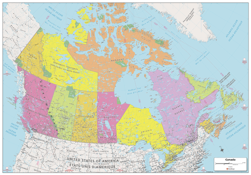
Canada Political Map - Large
Explore the vastness of Canada with this map created specifically for MapSherpa. From sea to sea, this Canadian Political Map displays the ten provinces and three territories that make up the country. Stretching from the Arctic in the north to both the Atlantic and Pacific Oceans, this map prominently shows; Province capitals, primary cities & towns, major national parks, primary water features, mountain ranges and all time zones. With multiple sizes available, this is the perfect reference map for home, office, or school use.
Page Size: 48 x 33.5 in (1219 x 851 mm)
Canada Postal Codes - Forward Sortation Areas
Custom postal code maps, grouped by forward sortation area (FSA), can be made for anywhere in Canada. FSAs are the first three characters of a postal code that represent roughly the same area as 5-digit Zip Codes in the United States. These attractive and informative maps include extensive geographic detail including: provincial highways; streets and street names at detailed scales; cities and towns; and, counties and province names and boundaries.Ideal for service delivery, retail siting, sales region planning and many other business and organizational functions.
Canada Roads and Recreation
This versatile product allows you to get a road map of anywhere in Canada. It has been designed so you can create a map for your next trip.This product has been designed to make custom road and street maps suitable for road trips and sightseeing. This map features comprehensive points of interest including attractions, landmarks, amenities, scenic views and local foot and bike paths. Also included is a complete network of highways, streets and roads you can count on.The details of this map make it ideal to plan a trip and take it with you. Travel with confidence using a map created specifically for the area you will be discovering.
Canada Streets
The MapSherpa Street product is ideal for the Business owner who needs local or regional road network information within a service delivery, catchment area or a sales territory. Information on the map highlights Municipal, Town and Zip Code boundaries. This multi-scale product for Canada uses the most current TomTom map data; you can count on this map showing the latest changes in your area. This product has been designed to make custom maps suitable from city to county scales, and anywhere in between. Rich regional maps include display highway infrastructure including, interchanges, weigh stations and tolls. Full street labelling, block numbers and street direction afford detailed city level maps. Infrastructure such as airports, hospitals, shopping malls, exhibition centers, industrial complexes and other business centric features are easily identifiable on the map.