


MapSherpa

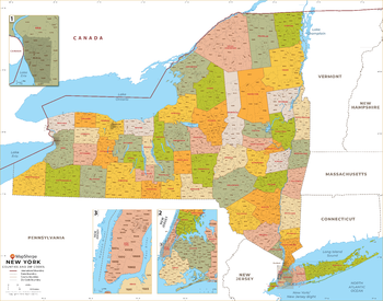
New York ZIP Code Map with Counties - Large
This map has been created exclusively for MapSherpa, and designed for business or reference use. Clear and clean colors & fonts matched with cartographic research makes this map of New York's counties and ZIP codes easily readable and useful.
Page Size: 48 x 37.75 in (1219 x 958 mm)
New York ZIP Code Map with Counties - Standard
This map has been created exclusively for MapSherpa, and designed for business or reference use. Clear and clean colors & fonts matched with cartographic research makes this map of New York's counties and ZIP codes easily readable and useful.
Page Size: 36 x 28.5 in (914 x 718 mm)
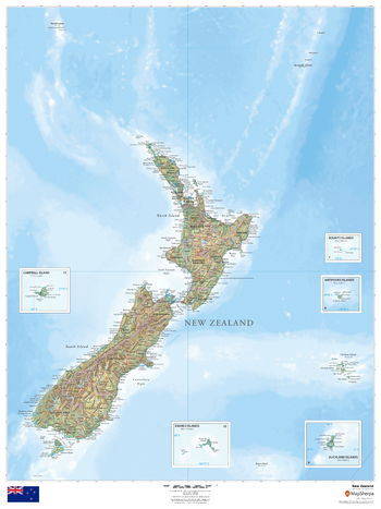
New Zealand
This beautiful map shows physical and political features for New Zealand and surrounding areas. Relief shading and the use of different colours by height above sea level are both informative and attractive.
Page Size: 36 x 48 in (914 x 1219 mm)
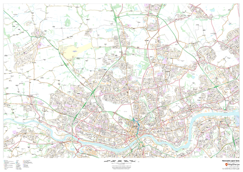
Newcastle upon Tyne
This map of Newcastle upon Tyne shows detailed street level information including extensive street labelling. Ideal for planning of deliveries, home services, sales territories, real estate and much more.
Page Size: 47 x 33.25 in (1189 x 841 mm)
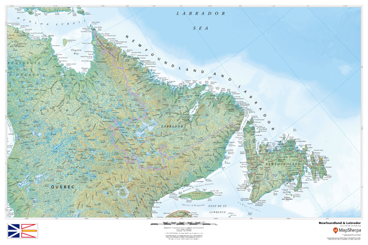
Newfoundland and Labrador
This beautiful map shows physical and political features for Newfoundland and Labrador, and surrounding areas. Relief shading and the use of different colours by height above sea level are both informative and attractive.
Page Size: 36 x 24 in (914 x 610 mm)
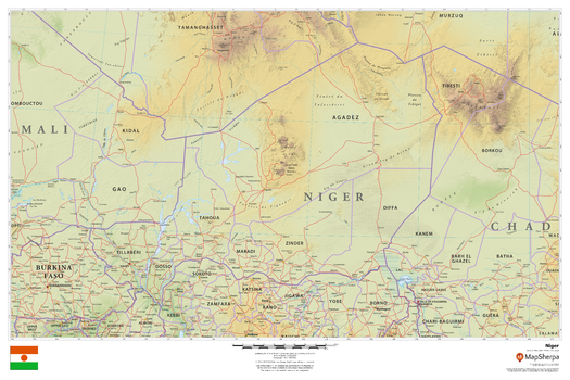
Niger
This beautiful map shows physical and political features for Niger and surrounding areas. Relief shading and the use of different colours by height above sea level are both informative and attractive.
Page Size: 36 x 24 in (914 x 610 mm)
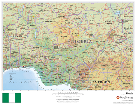
Nigeria
This beautiful map shows physical and political features for Nigeria and surrounding areas. Relief shading and the use of different colours by height above sea level are both informative and attractive.
Page Size: 22 x 17 in (559 x 432 mm)
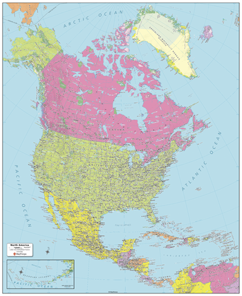
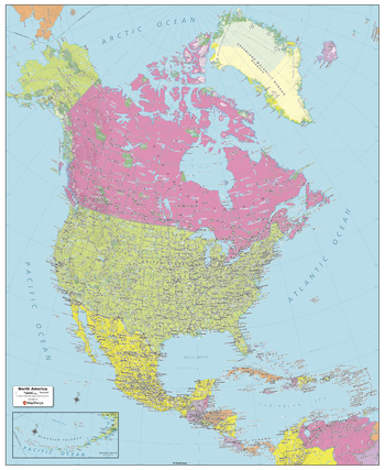
North America Political Map
Created specifically for MapSherpa, this North America Political Map shows all the countries that make up the continent; from Canada and Greenland in the extreme north, to the end of Panama and the Caribbean Islands in the south. Each country and its capital and major cities are noted, as well as the primary physical features such as mountain ranges, rivers, and lakes. For both Canada and the United States, the individual Province and State boundaries & capitals are noted. With multiple sizes available, this is the perfect reference map for home, office or school use.
Page Size: 24.25 x 29.5 in (610 x 749 mm)
North America Political Map - Compact
Created specifically for MapSherpa, this North America Political Map shows all the countries that make up the continent; from Canada and Greenland in the extreme north, to the end of Panama and the Caribbean Islands in the south. Each country and its capital and major cities are noted, as well as the primary physical features such as mountain ranges, rivers, and lakes. For both Canada and the United States, the individual Province and State boundaries & capitals are noted. With multiple sizes available, this is the perfect reference map for home, office or school use.
Page Size: 16 x 19.75 in (406 x 502 mm)
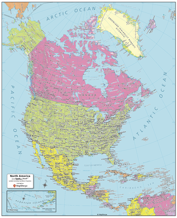
North America Political Map - Extra Large
Created specifically for MapSherpa, this North America Political Map shows all the countries that make up the continent; from Canada and Greenland in the extreme north, to the end of Panama and the Caribbean Islands in the south. Each country and its capital and major cities are noted, as well as the primary physical features such as mountain ranges, rivers, and lakes. For both Canada and the United States, the individual Province and State boundaries & capitals are noted. With multiple sizes available, this is the perfect reference map for home, office or school use.
Page Size: 40 x 49 in (1016 x 1245 mm)
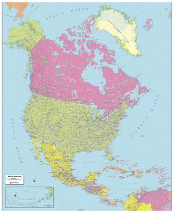
North America Political Map - Large
Created specifically for MapSherpa, this North America Political Map shows all the countries that make up the continent; from Canada and Greenland in the extreme north, to the end of Panama and the Caribbean Islands in the south. Each country and its capital and major cities are noted, as well as the primary physical features such as mountain ranges, rivers, and lakes. For both Canada and the United States, the individual Province and State boundaries & capitals are noted. With multiple sizes available, this is the perfect reference map for home, office or school use.
Page Size: 32 x 39 in (813 x 991 mm)

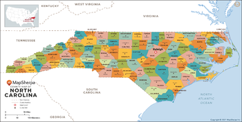
North Carolina Counties Map - Extra Large
This map has been created exclusively for MapSherpa, and designed for reference or business use. Clear and clean colors & fonts matched with cartographic research makes this map of North Carolina Counties Map easily readable and useful. The map shows the 100 counties of North Carolina and their borders across the Tar Heel State.
Page Size: 60 x 30.5 in (1524 x 772 mm)

North Carolina Counties Map - Large
This map has been created exclusively for MapSherpa, and designed for reference or business use. Clear and clean colors & fonts matched with cartographic research makes this map of North Carolina Counties Map easily readable and useful. The map shows the 100 counties of North Carolina and their borders across the Tar Heel State.
Page Size: 48 x 24.5 in (1219 x 618 mm)
North Carolina Counties Map - Standard
This map has been created exclusively for MapSherpa, and designed for reference or business use. Clear and clean colors & fonts matched with cartographic research makes this map of North Carolina Counties Map easily readable and useful. The map shows the 100 counties of North Carolina and their borders across the Tar Heel State.
Page Size: 36 x 18.25 in (914 x 463 mm)
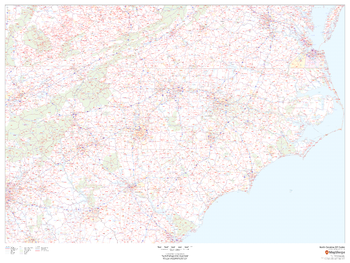
North Carolina ZIP Code Map
This map of North Carolina shows ZIP codes overlaid on a road map. Base map features include county boundaries, major road network features, and state and national parks and conservation areas.
Page Size: 48 x 36 in (1219 x 914 mm)

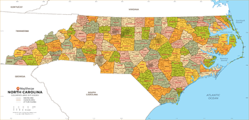
North Carolina ZIP Code Map with Counties - Extra Large
This map has been created exclusively for MapSherpa, and designed for business or reference use. Clear and clean colors & fonts matched with cartographic research makes this North Carolina Zip Code Map with Counties easily readable and useful. The map shows the 100 counties of North Carolina and the borders of the 802 zip codes across the Tar Heel State.
Page Size: 60 x 29.25 in (1524 x 739 mm)
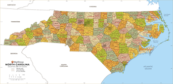
North Carolina ZIP Code Map with Counties - Large
This map has been created exclusively for MapSherpa, and designed for business or reference use. Clear and clean colors & fonts matched with cartographic research makes this North Carolina Zip Code Map with Counties easily readable and useful. The map shows the 100 counties of North Carolina and the borders of the 802 zip codes across the Tar Heel State.
Page Size: 48 x 23.5 in (1219 x 591 mm)
North Carolina ZIP Code Map with Counties - Standard
This map has been created exclusively for MapSherpa, and designed for business or reference use. Clear and clean colors & fonts matched with cartographic research makes this North Carolina Zip Code Map with Counties easily readable and useful. The map shows the 100 counties of North Carolina and the borders of the 802 zip codes across the Tar Heel State.
Page Size: 36 x 17.5 in (914 x 443 mm)
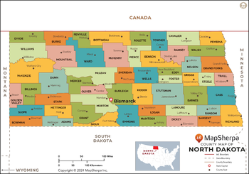
North Dakota Counties Map - Extra Large
This map has been created exclusively for MapSherpa, and designed for reference or business use. Clear and clean colors & fonts matched with cartographic research makes this map of the 53 North Dakota counties easily readable and useful.
Page Size: 60 x 42 in (1524 x 1067 mm)

North Dakota Counties Map - Large
This map has been created exclusively for MapSherpa, and designed for reference or business use. Clear and clean colors & fonts matched with cartographic research makes this map of the 53 North Dakota counties easily readable and useful.
Page Size: 48 x 33.75 in (1219 x 853 mm)