


MapSherpa
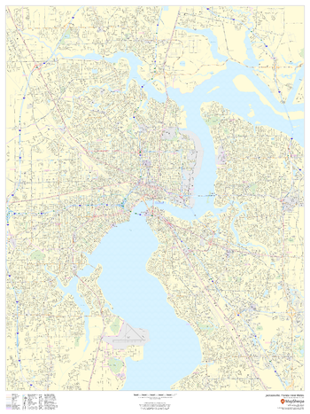
Jacksonville, Florida Inner Metro - Portrait
This portrait-oriented map of central Jacksonville, Florida shows detailed street level information including extensive street labeling. Ideal for planning of deliveries, home services, sales territories, real estate and much more. Base map features include all roads with major roads and highways labelled; neighborhood names; railways; high level land use such as parks and recreation areas, industrial areas and hospital campuses; and a variety of points of interest including schools, libraries, stadiums, museums, border crossings and more.
Page Size: 48 x 36 in (1219 x 914 mm)
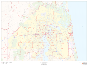
Jacksonville, Florida ZIP Codes
This map of Jacksonville shows ZIP code areas overlaid on a road map. Ideal for planning of deliveries, home services, sales territories, real estate and much more. Base map features include all roads with major roads and highways labelled; neighborhood names; railways; and high level land use such as parks and recreation areas, industrial areas and hospital campuses.
Page Size: 48 x 36 in (1219 x 914 mm)
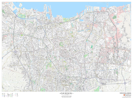
Jakarta, Indonesia Inner Metro
This detailed street map of central Jakarta, Indonesia shows the full road and rail networks, points of interest, and land use across the city. Useful for businesses operating in the city, or as consumer memorabilia of the city.
Page Size: 48 x 36 in (1219 x 914 mm)
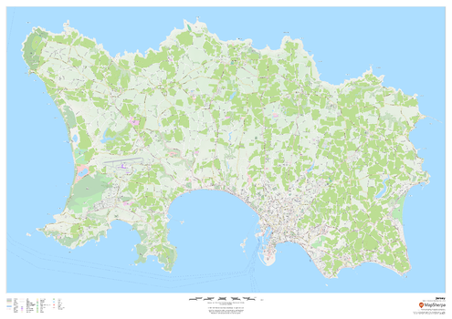
Jersey - Channel Islands
This wall map of Jersey in the Channel Islands features a clean design and rich detail designed for the traveller. Street mapping of the capital Saint Helier is included, along with land use, points of interest, and many of the building outlines. Walking paths throughout the island are displayed to assist with the local visitor.
Page Size: 47 x 33.25 in (1189 x 841 mm)
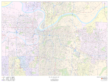
Kansas City, Missouri Inner Metro - Landscape
This landscape-oriented map of central Kansas City, Missouri shows detailed street level information including extensive street labeling. Ideal for planning of deliveries, home services, sales territories, real estate and much more. Base map features include all roads with major roads and highways labelled; neighborhood names; railways; high level land use such as parks and recreation areas, industrial areas and hospital campuses; and a variety of points of interest including schools, libraries, stadiums, museums, border crossings and more.
Page Size: 48 x 36 in (1219 x 914 mm)
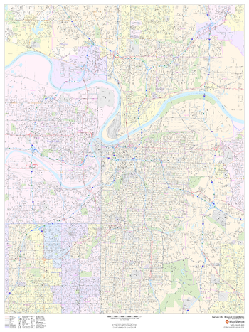
Kansas City, Missouri Inner Metro - Portrait
This portrait-oriented map of central Kansas City, Missouri shows detailed street level information including extensive street labeling. Ideal for planning of deliveries, home services, sales territories, real estate and much more. Base map features include all roads with major roads and highways labelled; neighborhood names; railways; high level land use such as parks and recreation areas, industrial areas and hospital campuses; and a variety of points of interest including schools, libraries, stadiums, museums, border crossings and more.
Page Size: 36 x 48 in (914 x 1219 mm)
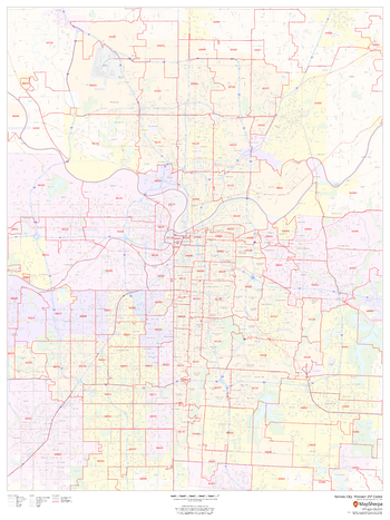
Kansas City, Missouri ZIP Codes
This map of Kansas City, Missouri shows ZIP code areas overlaid on a road map. Ideal for planning of deliveries, home services, sales territories, real estate and much more. Base map features include all roads with major roads and highways labelled; neighborhood names; railways; and high level land use such as parks and recreation areas, industrial areas and hospital campuses.
Page Size: 36 x 48 in (914 x 1219 mm)

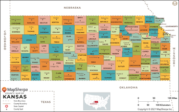
Kansas Counties Map - Extra Large
This map has been created exclusively for MapSherpa, and designed for reference or business use. Clear and clean colors & fonts matched with cartographic research makes this map of Kansas Counties Map easily readable and useful. The map shows the 105 counties of Kansas and their borders across the Sunflower State.
Page Size: 60 x 37.75 in (1524 x 953 mm)

Kansas Counties Map - Large
This map has been created exclusively for MapSherpa, and designed for reference or business use. Clear and clean colors & fonts matched with cartographic research makes this map of Kansas Counties Map easily readable and useful. The map shows the 105 counties of Kansas and their borders across the Sunflower State.
Page Size: 48 x 30.25 in (1219 x 763 mm)
Kansas Counties Map - Standard
This map has been created exclusively for MapSherpa, and designed for reference or business use. Clear and clean colors & fonts matched with cartographic research makes this map of Kansas Counties Map easily readable and useful. The map shows the 105 counties of Kansas and their borders across the Sunflower State.
Page Size: 36 x 22.75 in (914 x 572 mm)
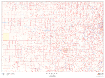
Kansas ZIP Code Map
This map of Kansas shows ZIP codes overlaid on a road map. Base map features include municipality and county boundaries, major road network features, and state and national parks and conservation areas.
Page Size: 48 x 36 in (1219 x 914 mm)
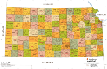
Kansas ZIP Code Map with Counties - Extra Large
This map has been created exclusively for MapSherpa, and designed for business or reference use. Clear and clean colors & fonts matched with cartographic research makes this Kansas Zip Code Map with Counties easily readable and useful. The map shows the 105 counties of Kansas and the borders of the 697 zip codes across the Sunflower State.
Page Size: 60 x 39.25 in (1524 x 995 mm)

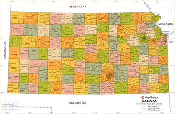
Kansas ZIP Code Map with Counties - Large
This map has been created exclusively for MapSherpa, and designed for business or reference use. Clear and clean colors & fonts matched with cartographic research makes this Kansas Zip Code Map with Counties easily readable and useful. The map shows the 105 counties of Kansas and the borders of the 697 zip codes across the Sunflower State.
Page Size: 48 x 31.5 in (1219 x 796 mm)
Kansas ZIP Code Map with Counties - Standard
This map has been created exclusively for MapSherpa, and designed for business or reference use. Clear and clean colors & fonts matched with cartographic research makes this Kansas Zip Code Map with Counties easily readable and useful. The map shows the 105 counties of Kansas and the borders of the 697 zip codes across the Sunflower State.
Page Size: 36 x 23.5 in (914 x 597 mm)
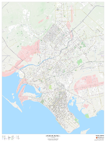
Karachi, Pakistan
This detailed street map of Karachi, Pakistan shows the full road and rail networks, points of interest, and land use across the city. Useful for businesses operating in the city, or as consumer memorabilia of the city.
Page Size: 36 x 48 in (914 x 1219 mm)
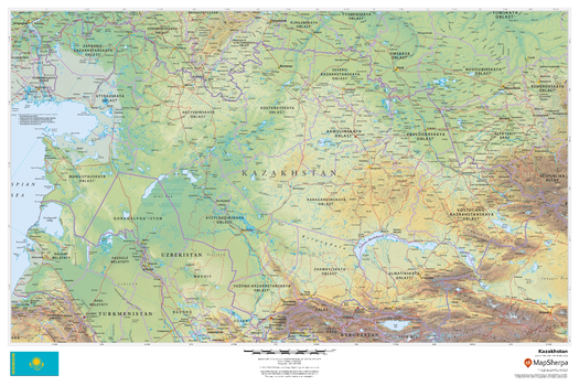
Kazakhstan
This beautiful map shows physical and political features for Kazakhstan and surrounding areas. Relief shading and the use of different colours by height above sea level are both informative and attractive.
Page Size: 36 x 24 in (914 x 610 mm)
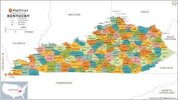
Kentucky Counties Map - Extra Large
This map has been created exclusively for MapSherpa, and designed for reference or business use. Clear and clean colors & fonts matched with cartographic research makes this map of Kentucky Counties Map easily readable and useful. The map shows the 120 counties of Kentucky and their borders across the Bluegrass State.
Page Size: 60 x 33.75 in (1524 x 857 mm)

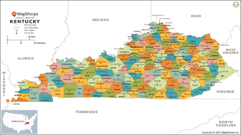
Kentucky Counties Map - Large
This map has been created exclusively for MapSherpa, and designed for reference or business use. Clear and clean colors & fonts matched with cartographic research makes this map of Kentucky Counties Map easily readable and useful. The map shows the 120 counties of Kentucky and their borders across the Bluegrass State.
Page Size: 48 x 27 in (1219 x 686 mm)
Kentucky Counties Map - Standard
This map has been created exclusively for MapSherpa, and designed for reference or business use. Clear and clean colors & fonts matched with cartographic research makes this map of Kentucky Counties Map easily readable and useful. The map shows the 120 counties of Kentucky and their borders across the Bluegrass State.
Page Size: 36 x 20.25 in (914 x 514 mm)
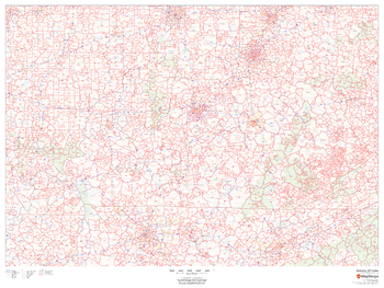
Kentucky ZIP Code Map
This map of Kentucky shows ZIP codes overlaid on a road map. Base map features include municipality and county boundaries, major road network features, and state and national parks and conservation areas.
Page Size: 48 x 36 in (1219 x 914 mm)