Globe Turner
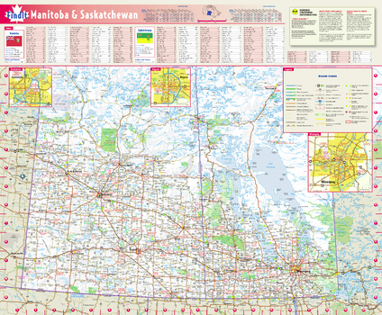
Manitoba & Saskatchewan Wall Map
This colorful, easy-to-read province map of Manitoba & Saskatchewan identifies all major thoroughfares, secondary roads, freeway interchanges, rest areas, distance markers, landmarks, recreational areas, and more. Shaded relief on the province map provides a three-dimensional sense of Manitoba & Saskatchewan's topography. Detailed city inset maps of Regina, Saskatoon and Winnipeg are based on the latest street information from our cartographic experts. The map also includes the latest border crossing information. A city index makes it simple to locate even the smallest town.
Page Size: 17.75 x 21.75 in (451 x 546 mm)
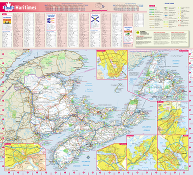
Maritimes Provinces Wall Map
This colorful, easy-to-read map of the Canadian Maritimes identifies all major thoroughfares, secondary roads, freeway interchanges, rest areas, distance markers, landmarks, recreational areas, and more. Shaded relief on the Maritimes map provides a three-dimensional sense of the topography of New Brunswick, Nova Scotia, Prince Edward Island, and Newfoundland and Labrador. Detailed city inset maps of Fredericton, Moncton, Saint John, Halifax, Charlottetown and St. John's are based on the latest street information from our cartographic experts. The map also includes the latest border crossing information. A city index makes it simple to locate even the smallest town.
Page Size: 19.5 x 21.75 in (495 x 546 mm)
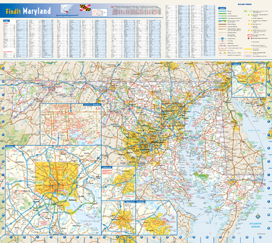
Maryland State Wall Map
This colorful, easy-to-read state map of Maryland identifies all major thoroughfares, secondary roads, freeway interchanges, rest areas, distance markers, landmarks, recreational areas, and more. Shaded relief on the state map provides a three-dimensional sense of Maryland's topography. Detailed city inset maps of Annapolis, Baltimore, Cumberland, Frederick, and Hagerstown are based on the latest street information from our cartographic experts. County and city indices make it simple to locate even the smallest town.
Page Size: 20.75 x 18.5 in (524 x 467 mm)
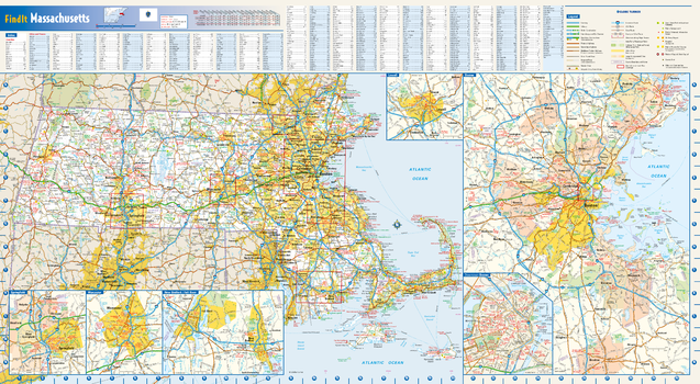
Massachusetts State Wall Map
This colorful, easy-to-read state map of Massachusetts identifies all major thoroughfares, secondary roads, freeway interchanges, rest areas, distance markers, landmarks, recreational areas, and more. Shaded relief on the state map provides a three-dimensional sense of Massachusetts' topography. Detailed inset maps of Boston, Lowell, New Bedford/Fall River, Springfield and Worcester are based on the latest street information from our cartographic experts. County and city indices make it simple to locate even the smallest town.
Page Size: 30.5 x 16.75 in (775 x 425 mm)
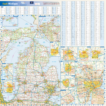
Michigan State Wall Map
This colorful, easy-to-read state map of Massachusetts identifies all major thoroughfares, secondary roads, freeway interchanges, rest areas, distance markers, landmarks, recreational areas, and more. Shaded relief on the state map provides a three-dimensional sense of Massachusetts' topography. Detailed inset maps of Boston, Lowell, New Bedford/Fall River, Springfield and Worcester are based on the latest street information from our cartographic experts. County and city indices make it simple to locate even the smallest town.
Page Size: 24 x 24 in (610 x 610 mm)
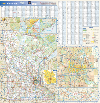
Minnesota State Wall Map
This colorful, easy-to-read state map of Minnesota identifies all major thoroughfares, secondary roads, freeway interchanges, rest areas, distance markers, landmarks, recreational areas, and more. Shaded relief on the state map provides a three-dimensional sense of Minnesota’s topography. Detailed city inset maps of Duluth, Rochester and the Twin Cities are based on the latest street information from our cartographic experts. Up-to-date insets of downtown Minneapolis and downtown St. Paul are included as well. County and city indices make it simple to locate even the smallest town. City type sizes reflect the 2020 U.S. Census.
Page Size: 24 x 24.75 in (610 x 629 mm)
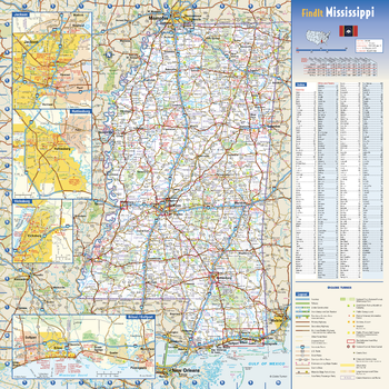
Mississippi State Wall Map
This colorful, easy-to-read state map of Mississippi identifies all major thoroughfares, secondary roads, freeway interchanges, rest areas, distance markers, landmarks, recreational areas, and more. Shaded relief on the state map provides a three-dimensional sense of Mississippi’s topography. Detailed city inset maps of Biloxi / Gulfport, Hattiesburg, Jackson and Vicksburg are based on the latest street information from our cartographic experts. County and city indices make it simple to locate even the smallest town.
Page Size: 16.75 x 16.75 in (425 x 425 mm)
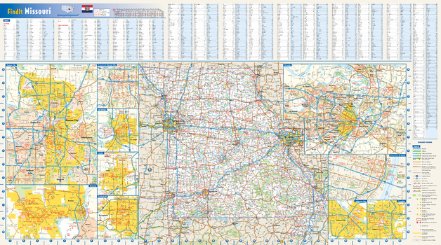
Missouri State Wall Map
This colorful, easy-to-read state map of Missouri identifies all major thoroughfares, secondary roads, freeway interchanges, rest areas, distance markers, landmarks, recreational areas, and more. Shaded relief on the state map provides a three-dimensional sense of Missouri's topography. Detailed city inset maps of Branson, Columbia, Jefferson City, Joplin, Kansas City, St. Louis, St. Joseph, and Springfield are based on the latest street information from our cartographic experts. Up-to-date insets of downtown Kansas City and downtown St. Louis depict the must-see attractions in those cities. County and city indices make it simple to locate even the smallest town.
Page Size: 32.75 x 18.25 in (832 x 464 mm)
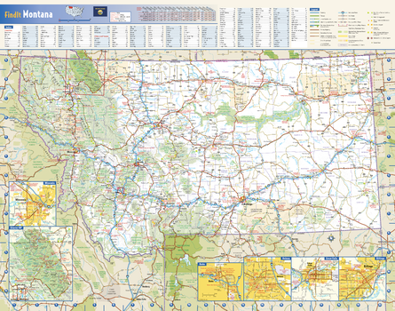
Montana State Wall Map
This colorful, easy-to-read state map of Montana identifies all major thoroughfares, secondary roads, freeway interchanges, rest areas, distance markers, landmarks, recreational areas, and more. Shaded relief on the state map provides a three-dimensional sense of Montana’s topography. Detailed city inset maps of Billings, Butte, Great Falls, Helena and Missoula are based on the latest street information from our cartographic experts. The map also includes up-to-date inset of Glacier National Park. County and city indices make it simple to locate even the smallest town. City type sizes reflect the 2020 U.S. Census.
Page Size: 22.25 x 17.5 in (565 x 445 mm)
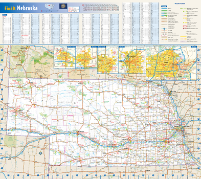
Nebraska State Wall Map
This colorful, easy-to-read state map of Nebraska identifies all major thoroughfares, secondary roads, freeway interchanges, rest areas, distance markers, landmarks, recreational areas, and more. Shaded relief on the state map provides a three-dimensional sense of Nebraska’s topography. Detailed inset maps of Grand Island, Kearney, Lincoln, North Platte, and Omaha are based on the latest street information from our cartographic experts. County and city indices make it simple to locate even the smallest town.
Page Size: 20.75 x 18.5 in (524 x 467 mm)
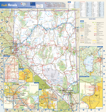
Nevada State Wall Map
This colorful, easy-to-read state map of Nevada identifies all major thoroughfares, secondary roads, freeway interchanges, rest areas, distance markers, landmarks, recreational areas, and more. Shaded relief on the state map provides a three-dimensional sense of Nevada’s topography. Detailed city inset maps of Carson City, Laughlin, Las Vegas, and Reno are based on the latest street information from our cartographic experts. Additional insets of the Las Vegas Strip and Lake Tahoe depict must-see points of interest in these tourist areas. County and city indices make it simple to locate even the smallest town. City type sizes reflect the 2020 U.S. Census.
Page Size: 16.75 x 17.75 in (425 x 451 mm)
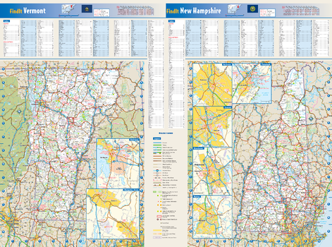
New Hampshire & Vermont State Wall Map
These colorful, easy-to-read state maps of New Hampshire and Vermont identify all major thoroughfares, secondary roads, freeway interchanges, rest areas, distance markers, landmarks, recreational areas, and more. Shaded relief on the state maps provides a three-dimensional sense of the topography. Detailed city inset maps of Concord, Manchester, Nashua, Portsmouth, Rochester, Burlington, and Montpelier are based on the latest street information from our cartographic experts. County and city indices for both states make it simple to locate even the smallest town.
Page Size: 25 x 18.5 in (629 x 467 mm)
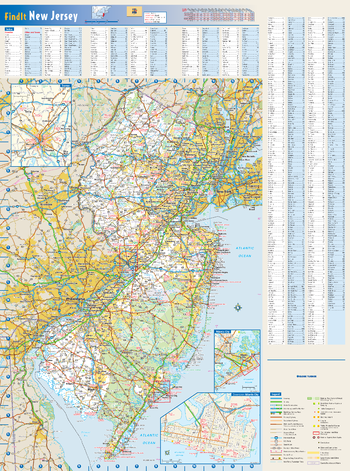
New Jersey State Wall Map
This colorful, easy-to-read state map of New Jersey identifies all major thoroughfares, secondary roads, freeway interchanges, rest areas, distance markers, landmarks, recreational areas, and more. Shaded relief on the state map provides a three-dimensional sense of New Jersey's topography. Detailed city inset maps of Atlantic City and Trenton are based on the latest street information from our cartographic experts. County and city indices make it simple to locate even the smallest town.
Page Size: 18.5 x 25 in (467 x 629 mm)
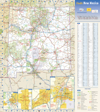
New Mexico State Wall Map
This colorful, easy-to-read state map of New Mexico identifies all major thoroughfares, secondary roads, freeway interchanges, rest areas, distance markers, landmarks, recreational areas, and more. Shaded relief on the state map provides a three-dimensional sense of New Mexico’s topography. Detailed city inset maps of Albuquerque, Las Cruces, Roswell, and Santa Fe are based on the latest street information from our cartographic experts. County and city indices make it simple to locate even the smallest town. City type sizes reflect the 2020 U.S. Census.
Page Size: 18.5 x 20.75 in (467 x 524 mm)
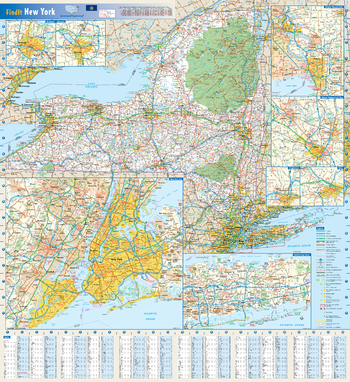
New York State Wall Map
This colorful, easy-to-read state map of New York identifies all major thoroughfares, secondary roads, freeway interchanges, rest areas, distance markers, landmarks, recreational areas, and more. Shaded relief on the state map provides a three-dimensional sense of New York's topography. Detailed city inset maps of Albany, Binghamton, Buffalo, New York City, Rochester, Syracuse, and Utica are based on the latest street information from our cartographic experts. County and city indices make it simple to locate even the smallest town.
Page Size: 25 x 27 in (629 x 686 mm)
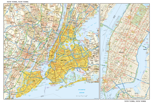
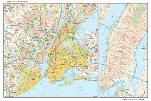
New York, New York Wall Map, large
This detailed reference map combines two maps in one - a regional map of New York that includes all five boroughs and northeastern New Jersey plus a street-level map of Midtown and Lower Manhattan. The regional map - including all of Manhattan, Brooklyn, Queens, Bronx, and Staten Island - shows the area’s cities and towns, highways and roads, and a variety of points of interest. The inset map of Midtown and Lower Manhattan shows highways, streets, parks, landmarks, and other points of interest. The Financial District, Little Italy, Greenwich Village, the Theater District and the areas around the southern half of Central Park are among the neighborhoods shown on this map. Also available in a small size of 29.00" high X 43.25" wide.
Page Size: 43.5 x 29 in (1099 x 737 mm)
New York, New York Wall Map, small
This detailed reference map combines two maps in one - a regional map of New York that includes all five boroughs and northeastern New Jersey plus a street-level map of Midtown and Lower Manhattan. The regional map - including all of Manhattan, Brooklyn, Queens, Bronx, and Staten Island - shows the area’s cities and towns, highways and roads, and a variety of points of interest. The inset map of Midtown and Lower Manhattan shows highways, streets, parks, landmarks, and other points of interest. The Financial District, Little Italy, Greenwich Village, the Theater District and the areas around the southern half of Central Park are among the neighborhoods shown on this map. Also available in a large size of 29.00" high X 43.25" wide.
Page Size: 21.75 x 14.5 in (549 x 368 mm)
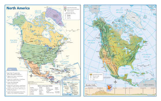
North America Political & Physical Continent Map
This map of the North American continent combines two maps in one - a vivid political map of North America showing all of the countries and major cities as well as a colorful topographic physical map depicting all of the major physical features in North America, including a cross-continent elevation profile. The political map includes a call-out box with interesting facts about the continent.
Page Size: 17 x 10.75 in (432 x 271 mm)
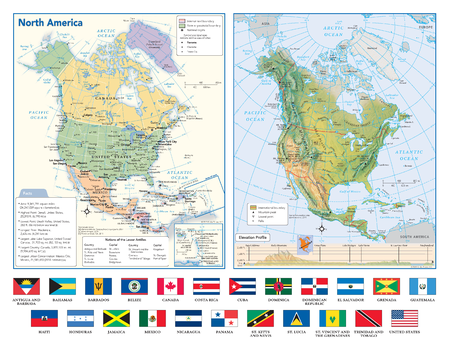
North America Political & Physical Continent Map with Country Flags
This map of the North American continent combines two maps in one - a vivid political map of North America showing all of the countries and major cities as well as a colorful topographic physical map depicting all of the major physical features in North America, including a cross-continent elevation profile. The political map includes a call-out box with interesting facts about the continent. The map also includes all 23 flags each North American country.
Page Size: 17 x 13.25 in (432 x 337 mm)
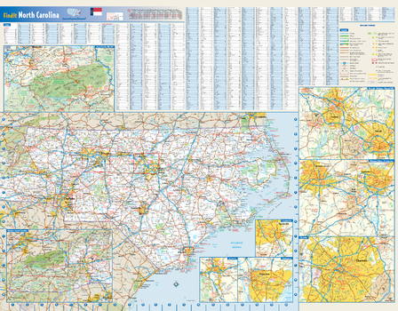
North Carolina State Wall Map
This colorful, easy-to-read state map of North Carolina identifies all major thoroughfares, secondary roads, freeway interchanges, rest areas, distance markers, landmarks, recreational areas, and more. Shaded relief on the state map provides a three-dimensional sense of North Carolina's topography. Detailed city inset maps of Asheville, Charlotte, Fayetteville, Greensboro/Winston-Salem, Raleigh/Durham, and Wilmington are based on the latest street information from our cartographic experts. An inset of Great Smoky Mountains National Park provides must-see information on this recreational area. County and city indices make it simple to locate even the smallest town.
Page Size: 27.5 x 21.75 in (699 x 546 mm)