Globe Turner
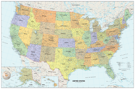
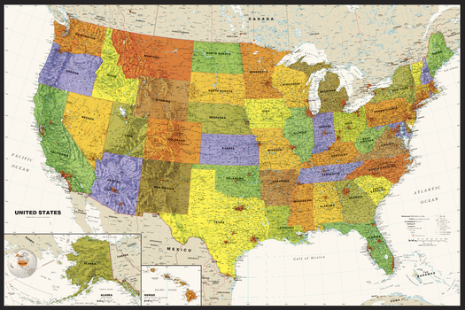
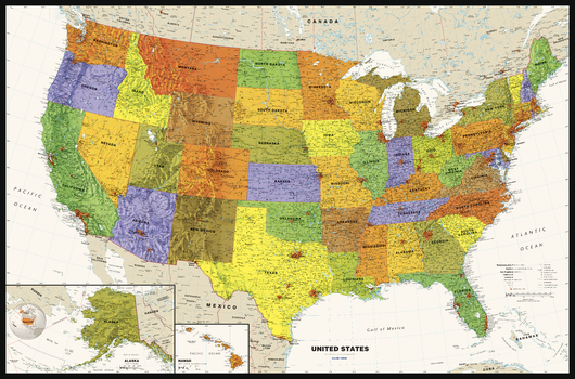
Classic USA Wall Map
Perfect for home, business, or school, this Classic USA Wall Map combines warm, attractive colors with high-detailed cartography. Details on this United States Wall Map include: state boundaries and capitals along with other major cities and towns; major physical features such as mountain ranges and major mountain peaks; major water features such as oceans, seas, gulfs, and rivers; the Interstate highway system and other major roads; and all National Parks as well as other large National Park Service sites. Special features include traditional, blue-colored oceans and a white decorative border. This map of the United States uses the Albers Equal Area projection.
Page Size: 50 x 33 in (1270 x 838 mm)
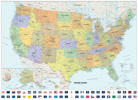
Classic USA Wall Map with Flags
Perfect for home, business, or school, this Classic USA Wall Map with Flags combines warm, attractive colors with high-detailed cartography. Details on this United States Wall Map include: state boundaries and capitals along with other major cities and towns; major physical features such as mountain ranges and major mountain peaks; major water features such as oceans, seas, gulfs, and rivers; the Interstate highway system and other major roads; all National Parks as well as other large National Park Service sites; and flags of all 50 states and the District of Columbia. Special features include traditional, blue-colored oceans and a white decorative border. This map of the United States uses the Albers Equal Area projection.
Page Size: 50 x 36.25 in (1270 x 921 mm)
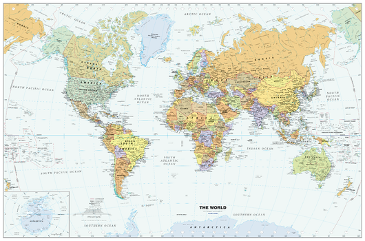
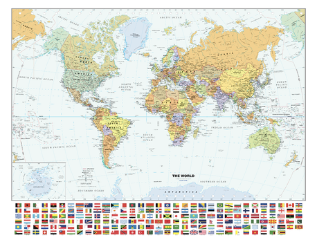
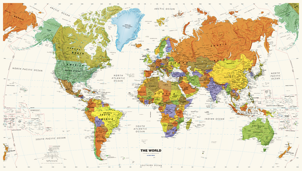
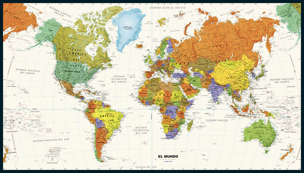
Classic World Wall Map - Large
Perfect for home, business, or school, this Classic World Wall Map combines warm, traditional colors with high-detailed cartography. Details on this World Wall Map include: international boundaries and national capitals along with other major cities; major physical features such as mountain ranges, major mountain peaks, island chains, and deserts; and major water features such as oceans, seas, gulfs, and rivers. Special features include light blue-colored oceans, a white border, and an inset of Antarctica. This map of the world uses the Van Der Grinten projection. This 2024 edition map from Globe Turner reflects the name change of Kazakhstan’s capital city from Nur-Sultan to Astana, the addition of a second capital city symbol in Indonesia to reflect the move of the capital from Jakarta to Nusantara in August 2024, and the addition of the place name for the world’s newest desert, the Aralkum—in what had been the lakebed of the Aral Sea along the border of Kazakhstan and Uzbekistan.
Page Size: 50 x 33 in (1270 x 838 mm)
Classic World Wall Map - Poster
Perfect for home, business, or school, this Classic World Wall Map combines warm, traditional colors with high-detailed cartography. Details on this World Wall Map include: international boundaries and national capitals along with other major cities; major physical features such as mountain ranges, major mountain peaks, island chains, and deserts; and major water features such as oceans, seas, gulfs, and rivers. Special features include light blue-colored oceans, a white border, and an inset of Antarctica. This map of the world uses the Van Der Grinten projection. This 2024 edition map from Globe Turner reflects the name change of Kazakhstan’s capital city from Nur-Sultan to Astana, the addition of a second capital city symbol in Indonesia to reflect the move of the capital from Jakarta to Nusantara in August 2024, and the addition of the place name for the world’s newest desert, the Aralkum—in what had been the lakebed of the Aral Sea along the border of Kazakhstan and Uzbekistan.
Page Size: 36 x 24 in (914 x 610 mm)
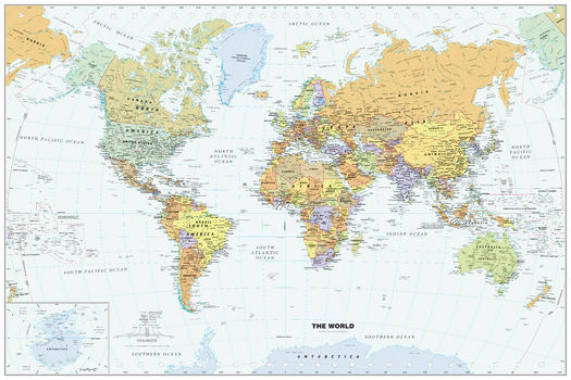
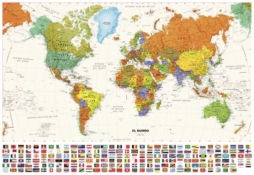
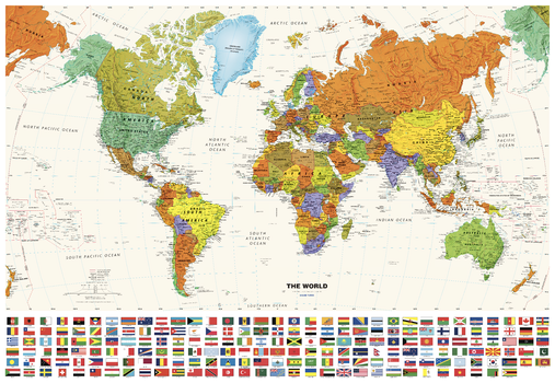
Classic World Wall Map with Flags - Large
Perfect for home, business, or school, this Classic World Wall Map combines warm, traditional colors with high-detailed cartography. Details on this World Wall Map include: international boundaries and national capitals along with other major cities; major physical features such as mountain ranges, major mountain peaks, island chains, and deserts; and major water features such as oceans, seas, gulfs, and rivers. Special features include light blue-colored oceans, a white border, and an inset of Antarctica. This map of the world uses the Van Der Grinten projection. This 2024 edition map from Globe Turner reflects the name change of Kazakhstan’s capital city from Nur-Sultan to Astana, the addition of a second capital city symbol in Indonesia to reflect the move of the capital from Jakarta to Nusantara in August 2024, and the addition of the place name for the world’s newest desert, the Aralkum—in what had been the lakebed of the Aral Sea along the border of Kazakhstan and Uzbekistan. The flags of countries around the world are listed in alphabetical order with the latest colors and dimensions used as approved by each country—including updates to the flags of Barbados and Kyrgyzstan.
Page Size: 53 x 40.5 in (1346 x 1029 mm)
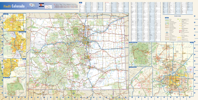
Colorado State Wall Map
This colorful, easy-to-read state map of Colorado identifies all major thoroughfares, secondary roads, freeway interchanges, rest areas, distance markers, landmarks, recreational areas, and more. Shaded relief on the state map provides a three-dimensional sense of Colorado’s topography. Detailed city inset maps of Colorado Springs, Denver, For Collins, and Pueblo are based on the latest street information from our cartographic experts. The map also includes up-to-date insets of downtown Denver, Mesa Verde National Park and Rocky Mountain National Park. County and city indices make it simple to locate even the smallest town. City type sizes reflect the 2020 U.S. Census.
Page Size: 31.25 x 15.75 in (794 x 400 mm)
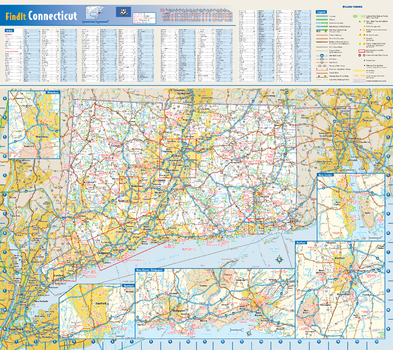
Connecticut State Wall Map
This colorful, easy-to-read state map of Connecticut identifies all major thoroughfares, secondary roads, freeway interchanges, rest areas, distance markers, landmarks, recreational areas, and more. Shaded relief on the state map provides a three-dimensional sense of Connecticut’s topography. Detailed city inset maps of Hartford, New Haven-Bridgeport, New London, Stamford, and Waterbury are based on the latest street information from our cartographic experts. County and city indices make it simple to locate even the smallest town.
Page Size: 20.75 x 18.5 in (524 x 467 mm)
Contemporary USA Wall Map
Perfect for home, business, or school, this Contemporary USA Wall Map combines bright, attractive colors with highly-detailed cartography. Features displayed on the map include state boundaries and capitals along with other major cities and towns; physical geography such as mountain ranges, mountain peaks, seas, gulfs, rivers, and lakes; the Interstate Highway System and other major roads; and sites maintained by the National Park Service and other federal and state agencies. Data from the 2020 U.S. Census is used to show the relative sizes of cities in the United States along with the latest census information from neighboring countries. Special features include ivory-colored oceans and a black decorative border. This map of the United States uses the Albers Equal Area projection. The most significant highway update for this 2024 edition shows the completion of I-49 in northwest Arkansas and southwest Missouri.
Page Size: 36 x 24 in (914 x 610 mm)
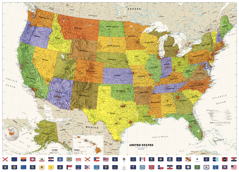
Contemporary USA Wall Map - Large
Perfect for home, business, or school, this Contemporary USA Wall Map combines bright, attractive colors with highly-detailed cartography. Features displayed on the map include state boundaries and capitals along with other major cities and towns; physical geography such as mountain ranges, mountain peaks, seas, gulfs, rivers, and lakes; the Interstate Highway System and other major roads; and sites maintained by the National Park Service and other federal and state agencies. Data from the 2020 U.S. Census is used to show the relative sizes of cities in the United States along with the latest census information from neighboring countries. Special features include ivory-colored oceans and a black decorative border. This map of the United States uses the Albers Equal Area projection. The most significant highway update for this 2024 edition shows the completion of I-49 in northwest Arkansas and southwest Missouri.
Page Size: 50 x 33 in (1270 x 838 mm)
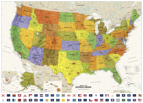
Contemporary USA Wall Map in Spanish with Flags, Mapa Mural Contemporáneo de EE.UU. en Español con Banderas - Large
Perfect for home, business, or school, this Contemporary USA Wall Map combines bright, attractive colors with highly-detailed cartography. Features displayed on the map include state boundaries and capitals along with other major cities and towns; physical geography such as mountain ranges, mountain peaks, seas, gulfs, rivers, and lakes; the Interstate Highway System and other major roads; and sites maintained by the National Park Service and other federal and state agencies. Data from the 2020 U.S. Census is used to show the relative sizes of cities in the United States along with the latest census information from neighboring countries. Special features include ivory-colored oceans and a black decorative border. This map of the United States uses the Albers Equal Area projection. The most significant highway update for this 2024 edition shows the completion of I-49 in northwest Arkansas and southwest Missouri. The flag set includes the new state flags for Minnesota and Utah that were adopted in 2024.
Perfecto para el hogar, la empresa o la escuela, este Mapa de pared contemporáneo de EE.UU. combina colores vivos y atractivos con una cartografía muy detallada. Las características que se muestran en el mapa incluyen las fronteras y capitales de los estados junto con otras ciudades y pueblos importantes; geografía física como cadenas montañosas, picos de montañas, mares, golfos, ríos y lagos; el sistema de autopistas interestatales y otras carreteras principales; y sitios mantenidos por el Servicio de Parques Nacionales y otras agencias federales y estatales. Los datos del Censo de EE.UU. de 2020 se utilizan para mostrar el tamaño relativo de las ciudades de Estados Unidos junto con la información censal más reciente de los países vecinos. Las características especiales incluyen océanos de color marfil y un borde decorativo negro. Este mapa de Estados Unidos utiliza la proyección Albers Equal Area. La actualización de carreteras más significativa de esta edición de 2024 muestra la finalización de la I-49 en el noroeste de Arkansas y el suroeste de Misuri. Las banderas están ordenadas alfabéticamente en español. Se incluyen las nuevas banderas estatales de Minesota y Utah, que se hicieron oficiales en 2024.
Traducción realizada con la versión gratuita del traductor DeepL.com
Page Size: 50 x 36 in (1270 x 914 mm)
Contemporary USA Wall Map in Spanish, Mapa Mural Contemporáneo de EE.UU. en Español
Perfect for home, business, or school, this Contemporary USA Wall Map combines bright, attractive colors with highly-detailed cartography. Features displayed on the map include state boundaries and capitals along with other major cities and towns; physical geography such as mountain ranges, mountain peaks, seas, gulfs, rivers, and lakes; the Interstate Highway System and other major roads; and sites maintained by the National Park Service and other federal and state agencies. Data from the 2020 U.S. Census is used to show the relative sizes of cities in the United States along with the latest census information from neighboring countries. Special features include ivory-colored oceans and a black decorative border. This map of the United States uses the Albers Equal Area projection. The most significant highway update for this 2024 edition shows the completion of I-49 in northwest Arkansas and southwest Missouri.
Page Size: 36 x 24 in (914 x 610 mm)

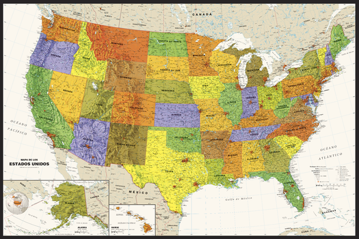
Contemporary USA Wall Map in Spanish, Mapa Mural Contemporáneo de EE.UU. en Español - Large
Perfect for home, business, or school, this Contemporary USA Wall Map combines bright, attractive colors with highly-detailed cartography. Features displayed on the map include state boundaries and capitals along with other major cities and towns; physical geography such as mountain ranges, mountain peaks, seas, gulfs, rivers, and lakes; the Interstate Highway System and other major roads; and sites maintained by the National Park Service and other federal and state agencies. Data from the 2020 U.S. Census is used to show the relative sizes of cities in the United States along with the latest census information from neighboring countries. Special features include ivory-colored oceans and a black decorative border. This map of the United States uses the Albers Equal Area projection. The most significant highway update for this 2024 edition shows the completion of I-49 in northwest Arkansas and southwest Missouri.
Perfecto para el hogar, la empresa o la escuela, este Mapa de pared contemporáneo de EE.UU. combina colores vivos y atractivos con una cartografía muy detallada. Las características que se muestran en el mapa incluyen las fronteras y capitales de los estados junto con otras ciudades y pueblos importantes; geografía física como cadenas montañosas, picos de montañas, mares, golfos, ríos y lagos; el sistema de autopistas interestatales y otras carreteras principales; y sitios mantenidos por el Servicio de Parques Nacionales y otras agencias federales y estatales. Los datos del Censo de EE.UU. de 2020 se utilizan para mostrar el tamaño relativo de las ciudades de Estados Unidos junto con la información censal más reciente de los países vecinos. Las características especiales incluyen océanos de color marfil y un borde decorativo negro. Este mapa de Estados Unidos utiliza la proyección Albers Equal Area. La actualización de carreteras más significativa de esta edición de 2024 muestra la finalización de la I-49 en el noroeste de Arkansas y el suroeste de Misuri.
Traducción realizada con la versión gratuita del traductor DeepL.com
Page Size: 50 x 33 in (1270 x 838 mm)
Contemporary USA Wall Map with Flags - Large
Perfect for home, business, or school, this Contemporary USA Wall Map combines bright, attractive colors with highly-detailed cartography. Features displayed on the map include state boundaries and capitals along with other major cities and towns; physical geography such as mountain ranges, mountain peaks, seas, gulfs, rivers, and lakes; the Interstate Highway System and other major roads; and sites maintained by the National Park Service and other federal and state agencies. Data from the 2020 U.S. Census is used to show the relative sizes of cities in the United States along with the latest census information from neighboring countries. Special features include ivory-colored oceans and a black decorative border. This map of the United States uses the Albers Equal Area projection. The most significant highway update for this 2024 edition shows the completion of I-49 in northwest Arkansas and southwest Missouri. The flag set includes the new state flags for Minnesota and Utah that were adopted in 2024.
Page Size: 50 x 36 in (1270 x 914 mm)
Contemporary World Wall Map
Perfect for home, business, or school, this Contemporary World Wall Map combines bright, attractive colors with high-detailed cartography. Details on this world map include: international boundaries and national capitals along with other major cities; major physical features such as mountain ranges, major mountain peaks, island chains, and deserts; and major water features such as oceans, seas, gulfs, straits, and rivers. This map features ivory-colored oceans, a black decorative border, and the Van Der Grinten projection. This 2024 edition map from Globe Turner reflects the name change of Kazakhstan's capital city from Nur-Sultan to Astana, the addition of a second capital city symbol in Indonesia to reflect the move of the capital from Jakarta to Nusantara in August 2024, and the addition of the place name for the world's newest desert, the Aralkum--in what had been the lakebed of the Aral Sea along the border of Kazakhstan and Uzbekistan.
Page Size: 36 x 20.5 in (914 x 521 mm)

Contemporary World Wall Map - Large
Perfect for home, business, or school, this Contemporary World Wall Map combines bright, attractive colors with high-detailed cartography. Details on this world map include: international boundaries and national capitals along with other major cities; major physical features such as mountain ranges, major mountain peaks, island chains, and deserts; and major water features such as oceans, seas, gulfs, straits, and rivers. This map features ivory-colored oceans, a black decorative border, and the Van Der Grinten projection. This 2024 edition map from Globe Turner reflects the name change of Kazakhstan's capital city from Nur-Sultan to Astana, the addition of a second capital city symbol in Indonesia to reflect the move of the capital from Jakarta to Nusantara in August 2024, and the addition of the place name for the world's newest desert, the Aralkum--in what had been the lakebed of the Aral Sea along the border of Kazakhstan and Uzbekistan.
Page Size: 50 x 28.5 in (1270 x 724 mm)
Contemporary World Wall Map in Spanish with Flags, Mapamundi Contemporáneo en Español con Banderas - Large
Perfect for home, business, or school, this Contemporary World Wall Map combines bright, attractive colors with high-detailed cartography. Details on this world map include: international boundaries and national capitals along with other major cities; major physical features such as mountain ranges, major mountain peaks, island chains, and deserts; and major water features such as oceans, seas, gulfs, straits, and rivers. This map features ivory-colored oceans, a white decorative border, and the Van Der Grinten projection. This 2024 edition map from Globe Turner reflects the name change of Kazakhstan's capital city from Nur-Sultan to Astana, the addition of a second capital city symbol in Indonesia to reflect the move of the capital from Jakarta to Nusantara in August 2024, and the addition of the place name for the world's newest desert, the Aralkum--in what had been the lakebed of the Aral Sea along the border of Kazakhstan and Uzbekistan. The flags of countries around the world are listed in alphabetical order with the latest colors and dimensions used as approved by each country--including updates to the flags of Barbados and Kyrgyzstan.
Perfecto para el hogar, la empresa o la escuela, este mapamundi contemporáneo combina colores vivos y atractivos con una cartografía muy detallada. Los detalles de este mapamundi incluyen: fronteras internacionales y capitales nacionales junto con otras ciudades importantes; características físicas principales como cordilleras, grandes picos montañosos, cadenas de islas y desiertos; y características acuáticas principales como océanos, mares, golfos, estrechos y ríos. Este mapa presenta océanos de color marfil, un borde decorativo blanco y la proyección Van Der Grinten. Este mapa de la edición de 2024 de Globe Turner refleja el cambio de nombre de la capital de Kazajstán de Nur-Sultan a Astana, la adición de un segundo símbolo de capital en Indonesia para reflejar el traslado de la capital de Yakarta a Nusantara en agosto de 2024, y la adición del topónimo del desierto más nuevo del mundo, el Aralkum, en lo que había sido el lecho del lago del Mar de Aral a lo largo de la frontera de Kazajstán y Uzbekistán. Las banderas de los países de todo el mundo aparecen en orden alfabético con los últimos colores y dimensiones aprobados por cada país, incluidas las actualizaciones de las banderas de Barbados y Kirguistán. Traducción realizada con la versión gratuita del traductor www.DeepL.com/Translator
Page Size: 50 x 34.5 in (1270 x 876 mm)

Contemporary World Wall Map in Spanish, Mapamundi Contemporáneo en Español
Perfect for home, business, or school, this Contemporary World Wall Map combines bright, attractive colors with high-detailed cartography. Details on this world map include: international boundaries and national capitals along with other major cities; major physical features such as mountain ranges, major mountain peaks, island chains, and deserts; and major water features such as oceans, seas, gulfs, straits, and rivers. This map features ivory-colored oceans, a black decorative border, and the Van Der Grinten projection. This 2024 edition map from Globe Turner reflects the name change of Kazakhstan's capital city from Nur-Sultan to Astana, the addition of a second capital city symbol in Indonesia to reflect the move of the capital from Jakarta to Nusantara in August 2024, and the addition of the place name for the world's newest desert, the Aralkum--in what had been the lakebed of the Aral Sea along the border of Kazakhstan and Uzbekistan.
Perfecto para el hogar, la empresa o la escuela, este mapamundi contemporáneo combina colores vivos y atractivos con una cartografía muy detallada. Los detalles de este mapamundi incluyen: fronteras internacionales y capitales nacionales junto con otras ciudades importantes; características físicas principales como cordilleras, grandes picos montañosos, cadenas de islas y desiertos; y características acuáticas principales como océanos, mares, golfos, estrechos y ríos. Este mapa presenta océanos de color marfil, un borde decorativo negro y la proyección Van Der Grinten. Este mapa de la edición de 2024 de Globe Turner refleja el cambio de nombre de la capital de Kazajstán de Nur-Sultan a Astana, la adición de un segundo símbolo de capital en Indonesia para reflejar el traslado de la capital de Yakarta a Nusantara en agosto de 2024, y la adición del topónimo del desierto más nuevo del mundo, el Aralkum, en lo que había sido el lecho del lago del Mar de Aral a lo largo de la frontera de Kazajstán y Uzbekistán. Traducción realizada con la versión gratuita del traductor www.DeepL.com/Translator
Page Size: 36 x 20.5 in (914 x 521 mm)
Contemporary World Wall Map in Spanish, Mapamundi Contemporáneo en Español - Large
Perfect for home, business, or school, this Contemporary World Wall Map combines bright, attractive colors with high-detailed cartography. Details on this world map include: international boundaries and national capitals along with other major cities; major physical features such as mountain ranges, major mountain peaks, island chains, and deserts; and major water features such as oceans, seas, gulfs, straits, and rivers. This map features ivory-colored oceans, a black decorative border, and the Van Der Grinten projection. This 2024 edition map from Globe Turner reflects the name change of Kazakhstan's capital city from Nur-Sultan to Astana, the addition of a second capital city symbol in Indonesia to reflect the move of the capital from Jakarta to Nusantara in August 2024, and the addition of the place name for the world's newest desert, the Aralkum--in what had been the lakebed of the Aral Sea along the border of Kazakhstan and Uzbekistan.
Perfecto para el hogar, la empresa o la escuela, este mapamundi contemporáneo combina colores vivos y atractivos con una cartografía muy detallada. Los detalles de este mapamundi incluyen: fronteras internacionales y capitales nacionales junto con otras ciudades importantes; características físicas principales como cordilleras, grandes picos montañosos, cadenas de islas y desiertos; y características acuáticas principales como océanos, mares, golfos, estrechos y ríos. Este mapa presenta océanos de color marfil, un borde decorativo negro y la proyección Van Der Grinten. Este mapa de la edición de 2024 de Globe Turner refleja el cambio de nombre de la capital de Kazajstán de Nur-Sultan a Astana, la adición de un segundo símbolo de capital en Indonesia para reflejar el traslado de la capital de Yakarta a Nusantara en agosto de 2024, y la adición del topónimo del desierto más nuevo del mundo, el Aralkum, en lo que había sido el lecho del lago del Mar de Aral a lo largo de la frontera de Kazajstán y Uzbekistán. Traducción realizada con la versión gratuita del traductor www.DeepL.com/Translator
Page Size: 50 x 28.5 in (1270 x 724 mm)
Contemporary World Wall Map with Flags - Large
Perfect for home, business, or school, this Contemporary World Wall Map combines bright, attractive colors with high-detailed cartography. Details on this world map include: international boundaries and national capitals along with other major cities; major physical features such as mountain ranges, major mountain peaks, island chains, and deserts; and major water features such as oceans, seas, gulfs, straits, and rivers. This map features ivory-colored oceans, a white decorative border, and the Van Der Grinten projection. This 2024 edition map from Globe Turner reflects the name change of Kazakhstan's capital city from Nur-Sultan to Astana, the addition of a second capital city symbol in Indonesia to reflect the move of the capital from Jakarta to Nusantara in August 2024, and the addition of the place name for the world's newest desert, the Aralkum--in what had been the lakebed of the Aral Sea along the border of Kazakhstan and Uzbekistan. The flags of countries around the world are listed in alphabetical order with the latest colors and dimensions used as approved by each country--including updates to the flags of Barbados and Kyrgyzstan.
Page Size: 50 x 34.5 in (1270 x 876 mm)
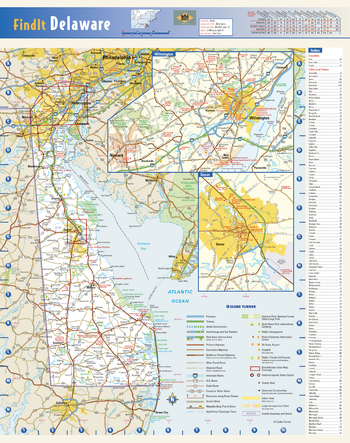
Delaware State Wall Map
This colorful, easy-to-read state map of Delaware identifies all major thoroughfares, secondary roads, freeway interchanges, rest areas, distance markers, landmarks, recreational areas, and more. Detailed inset maps of Dover and Wilmington are based on the latest street information from our cartographic experts. County and city indices make it simple to locate even the smallest town.
Page Size: 12.25 x 15.5 in (311 x 394 mm)