Globe Turner
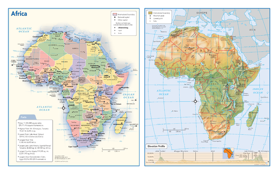
Africa Political & Physical Continent Map
This map of the African continent combines two maps in one - a vivid political map of Africa showing all of the countries and major cities as well as a colorful topographic physical map depicting all of the major physical features in Africa, including a cross-continent elevation profile. The political map includes a call-out box with interesting facts about the continent.
Page Size: 17 x 10.75 in (432 x 271 mm)
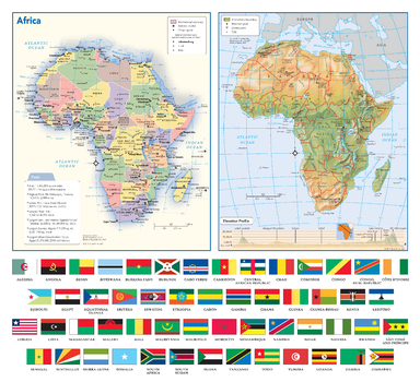
Africa Political & Physical Continent Map with Country Flags
This map of the African continent combines two maps in one - a vivid political map of Africa showing all of the countries and major cities as well as a colorful topographic physical map depicting all of the major physical features in Africa, including a cross-continent elevation profile. The political map includes a call-out box with interesting facts about the continent. The map also includes all 54 flags each African country.
Page Size: 17 x 15.5 in (432 x 394 mm)
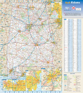
Alabama State Wall Map
This colorful, easy-to-read state map of Alabama identifies all major thoroughfares, secondary roads, freeway interchanges, rest areas, distance markers, landmarks, recreational areas, and more. Shaded relief on the state map provides a three-dimensional sense of Alabama’s topography. Detailed inset maps of Birmingham, Huntsville, Mobile, Montgomery, and Tuscaloosa are based on the latest street information from our cartographic experts. County and city indices make it simple to locate even the smallest town.
Page Size: 18.5 x 20.75 in (467 x 524 mm)
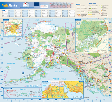
Alaska State Wall Map
This colorful, easy-to-read state map of Alaska identifies all major thoroughfares, secondary roads, freeway interchanges, rest areas, distance markers, landmarks, recreational areas, and more. Shaded relief on the state map provides a three-dimensional sense of Alaska's topography. Detailed city inset maps of Anchorage, Fairbanks and Juneau are based on the latest street information from our cartographic experts. The map also includes an up-to-date inset of Denali National Park. A city index makes it simple to locate even the smallest town.
Page Size: 16.75 x 15.25 in (425 x 387 mm)
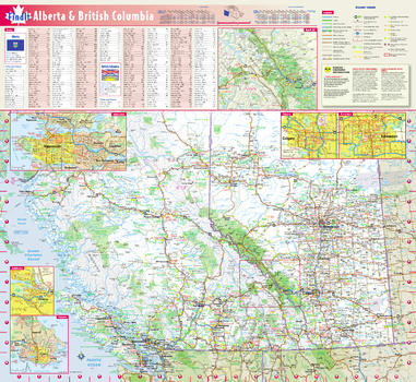
Alberta & British Columbia Wall Map
This colorful, easy-to-read province map of Alberta & British Columbia identifies all major thoroughfares, secondary roads, freeway interchanges, rest areas, distance markers, landmarks, recreational areas, and more. Shaded relief on the province map provides a three-dimensional sense of Alberta & British Columbia's topography. Detailed city inset maps of Calgary, Edmonton, Vancouver, Victoria and Kamloops are based on the latest street information from our cartographic experts. The map also includes up-to-date inset of Banff National Park, as well as the latest border crossing information. A city index makes it simple to locate even the smallest town.
Page Size: 19.75 x 21.75 in (502 x 546 mm)
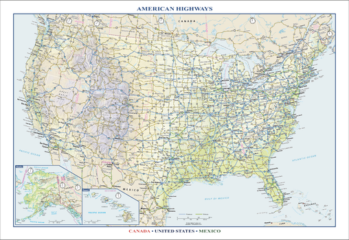
American Highways Wall Map
Perfect for home, business, or school, this American Highways wall map shows the Interstate Highway System of the United States, along with other important Federal and state highways. Details included on this wall map include: international and state/provincial boundaries; freeways, tollways, and other major roads; cities and towns; time zones; and National Parks in the United States. Insets of Alaska and Hawaii are also included on this map, along with parts of southern Canada and northern Mexico. Special features include colored relief and a white decorative border. City type sizes reflect the 2020 U.S. Census
Page Size: 22.75 x 15.5 in (572 x 394 mm)
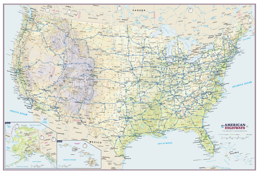
American Highways Wall Map - Poster
Perfect for home, business, or school, this American Highways wall map shows the Interstate Highway System of the United States, along with other important Federal and state highways. Details on this wall map include international and state/provincial boundaries; freeways, tollways, and other major roads; cities and towns; time zones; and all National Parks in the United States. Insets of Alaska and Hawaii are also included on this map.
Page Size: 36 x 24 in (914 x 610 mm)
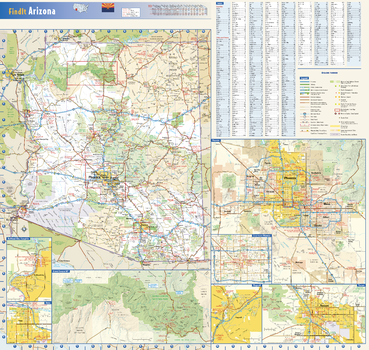
Arizona State Wall Map
This colorful, easy-to-read state map of Arizona identifies all major thoroughfares, secondary roads, freeway interchanges, rest areas, distance markers, landmarks, recreational areas, and more. Shaded relief on the state map provides a three-dimensional sense of Arizona’s topography. Detailed inset maps of Bullhead City, Flagstaff, Phoenix, Tucson, and Yuma are based on the latest street information from our cartographic experts. An up-to-date inset of Grand Canyon National Park provides must-see information on this popular tourist destination. County and city indices make it simple to locate even the smallest town. City type sizes reflect the 2020 U.S. Census.
Page Size: 23.75 x 22.5 in (603 x 572 mm)
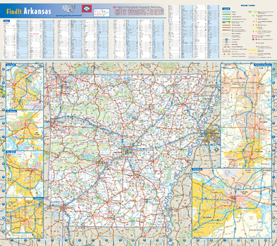
Arkansas State Wall Map
This colorful, easy-to-read state map of Arkansas identifies all major thoroughfares, secondary roads, freeway interchanges, rest areas, distance markers, landmarks, recreational areas, and more. Shaded relief on the state map provides a three-dimensional sense of Arkansas’ topography. Detailed inset maps of Fayetteville/Bentonville, Fort Smith, Hot Springs, Little Rock, Pine Bluff, and Texarkana are based on the latest street information from our cartographic experts. County and city indices make it simple to locate even the smallest town.
Page Size: 20.75 x 18.5 in (524 x 467 mm)
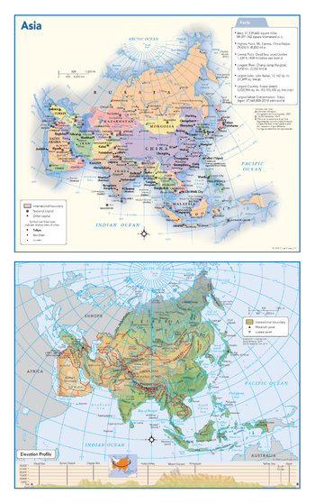
Asia Political & Physical Continent Map
This map of the Asian continent combines two maps in one - a vivid political map of Asia showing all of the countries and major cities as well as a colorful topographic physical map depicting all of the major physical features in Asia, including a cross-continent elevation profile. The political map includes a call-out box with interesting facts about the continent.
Page Size: 10.75 x 17 in (271 x 432 mm)
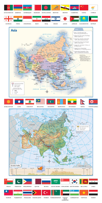
Asia Political & Physical Continent Map with Country Flags
This map of the Asian continent combines two maps in one - a vivid political map of Asia showing all of the countries and major cities as well as a colorful topographic physical map depicting all of the major physical features in Asia, including a cross-continent elevation profile. The political map includes a call-out box with interesting facts about the continent. The map also includes all 49 flags each Asian country.
Page Size: 11.75 x 23.25 in (298 x 591 mm)
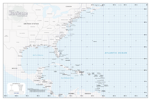
Atlantic Hurricane Tracking Map
Perfect for home, business, school, or governmental emergency planning agency, this map of the central and western North Atlantic Ocean, Caribbean Sea, and Gulf of Mexico is divided into one degree latitude and longitude grid lines to make the tracking of tropical systems easy.
Page Size: 36 x 24 in (914 x 610 mm)
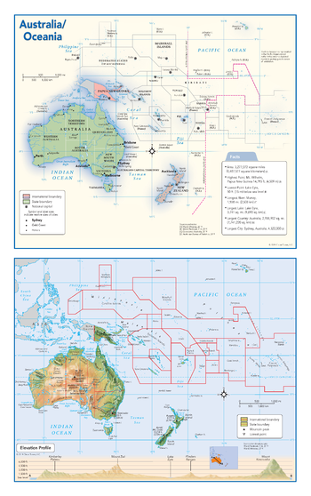
Australia and Oceania Political & Physical Continent Map
This map of the Australian continent and Oceania combines two maps in one - a vivid political map of Australia and Oceania showing all of the countries and major cities as well as a colorful topographic physical map depicting all of the major physical features in Australia and Oceania, including a cross-continent elevation profile. The political map includes a call-out box with interesting facts about the continent.
Page Size: 10.75 x 17 in (271 x 432 mm)
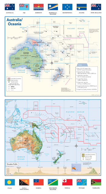
Australia and Oceania Political & Physical Continent Map with Country Flags
This map of the Australian continent and Oceania combines two maps in one - a vivid political map of Australia and Oceania showing all of the countries and major cities as well as a colorful topographic physical map depicting all of the major physical features in Australia and Oceania including a cross-continent elevation profile. The political map includes a call-out box with interesting facts about the continent. The map also includes all 14 flags each country that makes up Australia and Oceania.
Page Size: 10.75 x 19.5 in (271 x 495 mm)
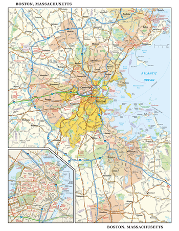
Boston, Massachusetts Wall Map, large
This detailed reference map combines two maps in one - a regional map of the Boston metropolitan area plus a street-level map of center-city Boston. The regional map shows the area’s cities and towns, highways and roads, and a variety of points of interest. Cambridge, Quincy, Salem and historic Lexington are among the neighboring cities and towns shown on this map. The highly detailed inset of central Boston shows highways, streets, parks, landmarks, and other points of interest. The North End, West End, Beacon Hill, and Chinatown are among the neighborhoods featured on this map. Also available in a small size of 14.50" high X 11.25" wide.
Page Size: 22.75 x 29 in (572 x 737 mm)
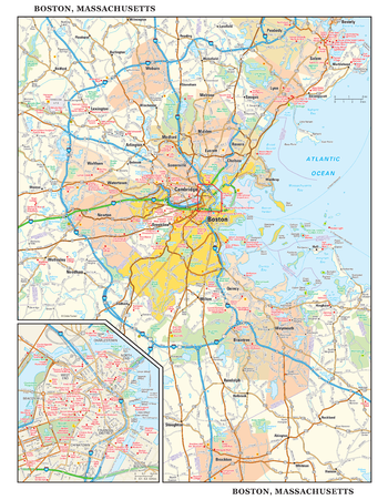
Boston, Massachusetts Wall Map, small
This detailed reference map combines two maps in one - a regional map of the Boston metropolitan area plus a street-level map of center-city Boston. The regional map shows the area’s cities and towns, highways and roads, and a variety of points of interest. Cambridge, Quincy, Salem and historic Lexington are among the neighboring cities and towns shown on this map. The highly detailed inset of central Boston shows highways, streets, parks, landmarks, and other points of interest. The North End, West End, Beacon Hill, and Chinatown are among the neighborhoods featured on this map. Also available in a large size of 29.00" high X 22.50" wide.
Page Size: 11.25 x 14.5 in (286 x 368 mm)
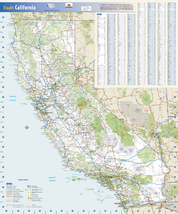
California State Wall Map
This colorful, easy-to-read state map of California identifies all major thoroughfares, secondary roads, freeway interchanges, distance markers, landmarks, recreational areas, and more. Shaded relief on the state map provides a three-dimensional sense of California’s topography. County and city indices make it simple to locate even the smallest town. City type sizes reflect the 2020 U.S. Census.
Page Size: 19.75 x 23.75 in (502 x 603 mm)
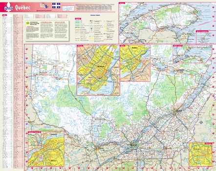
Carte du Québec, en français
Cette carte de province colorée et facile à lire du Québec identifie toutes les artères principales, les routes secondaires, les échangeurs d'autoroutes, les aires de repos, les repères de distance, les repères, les aires récréatives, et plus encore. Un relief ombré sur la carte de la province donne un aperçu tridimensionnel de la topographie du Québec. Les cartes détaillées de Montréal, Québec, Gatineau / Ottawa, ON et Sherbrooke sont basées sur les dernières informations de nos experts en cartographie. La carte comprend également des encarts mis à jour de l'est du Québec, de la Gaspésie et des Îles-de-la-Madeleine, ainsi que les dernières informations sur les passages frontaliers. Un index de ville le rend simple pour localiser même la plus petite ville.
Page Size: 19 x 24 in (483 x 610 mm)
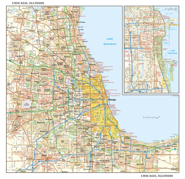
Chicago, Illinois Wall Map, large
This detailed reference map combines two maps in one - a regional map of the Chicagoland area plus a street-level map of downtown Chicago. The regional map shows the area’s cities and towns, highways and roads, and a variety of points of interest. Joliet, Aurora, Elgin, and Highland Park are among the suburbs near Chicago that are featured on this map. The highly detailed inset of the Chicago central business district shows highways, streets, parks, landmarks, and other points of interest. The Loop, Printer’s Row, Chinatown, and the Near North are among the neighborhoods shown on this map. Also available in a small size of 14.50" high X 15.00" high.
Page Size: 30 x 29 in (762 x 737 mm)
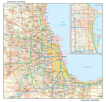
Chicago, Illinois Wall Map, small
This detailed reference map combines two maps in one - a regional map of the Chicagoland area plus a street-level map of downtown Chicago. The regional map shows the area’s cities and towns, highways and roads, and a variety of points of interest. Joliet, Aurora, Elgin, and Highland Park are among the suburbs near Chicago that are featured on this map. The highly detailed inset of the Chicago central business district shows highways, streets, parks, landmarks, and other points of interest. The Loop, Printer’s Row, Chinatown, and the Near North are among the neighborhoods shown on this map. Also available in a large size of 29.00" high X 30.00" high.
Page Size: 15 x 14.5 in (381 x 368 mm)