


MapSherpa Catalog
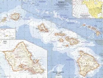
Hawaii - Published 1960
National Geographic
This map was created less than a year after Hawaii joined the United States as its 50th state. Features an overview map of the entire state as well as a detailed map of the principal islands. Ocean bathymetry, reefs and currents complete the picture of this exotic island region. Published in July 1960.
Page Size: 25 x 19 in (631 x 480 mm)
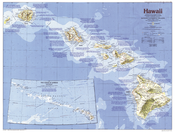
Hawaii - Published 1983
National Geographic
From volcanoes, lush forests, and magnificent beaches to historic Pearl Harbor and the bustle of Honolulu, it is no wonder that the Hawaiian Islands are a popular United States vacation site. This Hawaii map shows the complete chain of islands and reefs that make up the state, and also details its principal islands. Published in November 1983 as part of the "Making of America" series, and half of a two–map set with a Hawaii historical map.
Page Size: 27 x 20.5 in (685 x 519 mm)
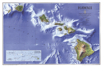
Hawaii - Published 1995
National Geographic
Breathtaking ocean-floor relief sets this map of Hawaii apart. Published in September 1995, this map accompanied the "Rediscovering Hawaii" map and the article "On the Brink: Hawaii's Vanishing Species."
Page Size: 31.25 x 20.25 in (794 x 513 mm)
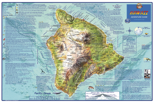
Hawaii "Big Island" Wall Map
Franko Maps
This map shows the island of Hawaii on a detailed dramatic relief map. Hypsometric tinting employs colors to visualize land heights and water depths. Descriptions of outdoor recreation opportunities, golf courses, points of interest and more.
Page Size: 36 x 24 in (914 x 610 mm)

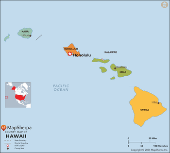
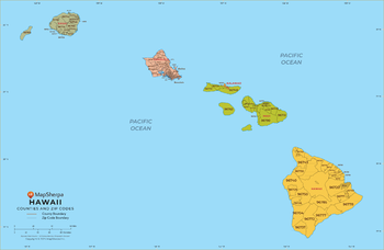
Hawaii Counties Map - Extra Large
MapSherpa
This map has been created exclusively for MapSherpa, and designed for reference or business use. Clear and clean colors & fonts matched with cartographic research makes this map of the 5 Hawaii counties easily readable and useful.
Page Size: 60 x 54.25 in (1524 x 1373 mm)

Hawaii Counties Map - Large
MapSherpa
This map has been created exclusively for MapSherpa, and designed for reference or business use. Clear and clean colors & fonts matched with cartographic research makes this map of the 5 Hawaii counties easily readable and useful.
Page Size: 48 x 43.25 in (1219 x 1098 mm)
Hawaii Counties Map - Standard
MapSherpa
This map has been created exclusively for MapSherpa, and designed for reference or business use. Clear and clean colors & fonts matched with cartographic research makes this map of the 5 Hawaii counties easily readable and useful.
Page Size: 36 x 32.5 in (914 x 824 mm)
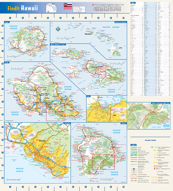
Hawaii State Wall Map
Globe Turner
This colorful, easy-to-read state map of Hawaii identifies all major thoroughfares, secondary roads, freeway interchanges, rest areas, distance markers, landmarks, recreational areas, and more. Shaded relief on each island map provides a three-dimensional sense of Hawaii's topography. Detailed inset maps of Hilo and Honolulu are based on the latest street information from our cartographic experts. The map also includes an up-to-date inset of Hawaii Volcanoes National Park. County and city indices make it simple to locate even the smallest town.
Page Size: 16.5 x 18.25 in (419 x 464 mm)
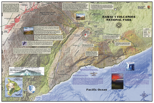
Hawaii Volcanoes National Park Wall Map
Franko Maps
Discover the wild beauty of creation with the most up to date map of this fascinating park, a UNESCO World Heritage Site. Filled with map details and text for park visitors, including roads, campsites, the history of lava flows from Kilauea and Mauna Loa.
Page Size: 36 x 24 in (914 x 610 mm)
Hawaii ZIP Code Map
MapSherpa
This map of Hawaii shows ZIP codes overlaid on a road map. Base map features include municipality and county boundaries, major road network features, and state and national parks and conservation areas.
Page Size: 48 x 36 in (1219 x 914 mm)

Hawaii ZIP Code Map with Counties - Extra Large
MapSherpa
This map has been created exclusively for MapSherpa, and designed for business or reference use. Clear and clean colors & fonts matched with cartographic research makes this map of Hawaii's counties and ZIP codes easily readable and useful.
Page Size: 60 x 39.25 in (1524 x 995 mm)
Hawaii ZIP Code Map with Counties - Large
MapSherpa
This map has been created exclusively for MapSherpa, and designed for business or reference use. Clear and clean colors & fonts matched with cartographic research makes this map of Hawaii's counties and ZIP codes easily readable and useful.
Page Size: 48 x 31.5 in (1219 x 796 mm)

Hawaii ZIP Code Map with Counties - Standard
MapSherpa
This map has been created exclusively for MapSherpa, and designed for business or reference use. Clear and clean colors & fonts matched with cartographic research makes this map of Hawaii's counties and ZIP codes easily readable and useful.
Page Size: 36 x 23.75 in (914 x 597 mm)
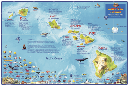
Hawaiian Islands Wall Map
Franko Maps
A colorful map of the entire island chain with shaded relief. Hypsometric tinting employs color to denote land heights and water depths. Dozens of Hawaii's exotic fish and reef creatures are beautifully illustrated. Facts and statistics for each island.
Page Size: 36 x 24 in (914 x 610 mm)

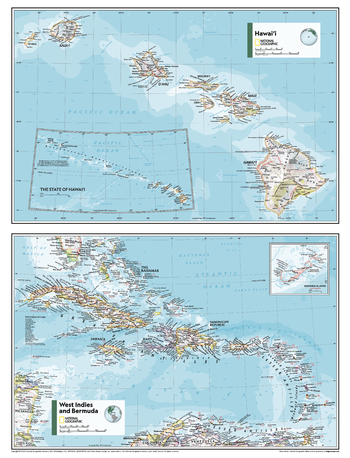
Hawai’i, West Idies and Bermuda - Atlas of the World, 11th Edition
National Geographic
This Hawai'i, West Indies and Bermuda map of physical and political features can fit in any space. Showcasing the regions in stunning detail with state-of-the-art cartographic techniques delivering accuracy and exceptional quality, the innovative and engaging design makes the content easily accessible and user-friendly.
Ideal for classrooms with an emphasis on teaching geography or environmental themes. Physical maps give your students a genuine feel for how our world appears.
This map uses a bright, easy to read color palette featuring blue oceans and stunning shaded relief that has been featured on National Geographic wall maps for over 75 years. Drawn in the Azimuthal Equidistant projection, this map ensures that all points on the map are at proportionally correct distances from the center point.
This map is found in National Geographic's 11th Edition World Atlas and is now available as a stand alone product.
Page Size: 24 x 31.5 in (610 x 798 mm)
Hawai’i, West Idies and Bermuda - Atlas of the World, 11th Edition - Compact
National Geographic
This Hawai'i, West Indies and Bermuda map of physical and political features can fit in any space. Showcasing the regions in stunning detail with state-of-the-art cartographic techniques delivering accuracy and exceptional quality, the innovative and engaging design makes the content easily accessible and user-friendly.
Ideal for classrooms with an emphasis on teaching geography or environmental themes. Physical maps give your students a genuine feel for how our world appears.
This map uses a bright, easy to read color palette featuring blue oceans and stunning shaded relief that has been featured on National Geographic wall maps for over 75 years. Drawn in the Azimuthal Equidistant projection, this map ensures that all points on the map are at proportionally correct distances from the center point.
This map is found in National Geographic's 11th Edition World Atlas and is now available as a stand alone product.
Page Size: 16.25 x 21.5 in (413 x 540 mm)
Hay Lake Quadrangle, Arizona
United States Department of Agriculture Forest Service
United States Department of Agriculture Forestry Service topographical map of Hay Lake, Coconino National Forest, Arizona.
Page Size: 21.75 x 27 in (552 x 686 mm)
Haypress Valley Quadrangle, California
United States Department of Agriculture Forest Service
United States Department of Agriculture Forestry Service topographical map of Haypress Valley, Tahoe National Forest, California.
Page Size: 21.75 x 27 in (552 x 686 mm)
Hayward Quadrangle, South Dakota
United States Department of Agriculture Forest Service
United States Department of Agriculture Forestry Service topographical map of Hayward, Black Hills National Forest, South Dakota.
Page Size: 21.75 x 27 in (552 x 686 mm)
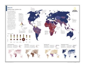
Health: Seeking Longer, Healthier Lives - Atlas of the World, 10th Edition
National Geographic
Mapping Mortality; Comparing Income and Life Expectancy; Locating the HIV/AIDS Epidemic; Under-Five Mortality; Mapping Malaria's Range; Measuring Health-Care Expenditures
Page Size: 28 x 22 in (711 x 559 mm)
No search results