


MapSherpa Catalog
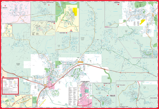
Flagstaff and Vicinity Map
GM Johnson
Flagstaff / Sedona / Grand Canyon, Arizona Street Map. Map Coverage Area: Blue Ridge, Forest Lakes Estates, Fredonia, Kachina Village, Mountainaire, Mormon Lake, Munds Park, Pinewood, Page, Tuba City, Williams & Coconino County
Page Size: 39.5 x 27.25 in (1003 x 692 mm)
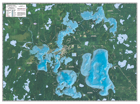
Flambeau Chain
Mapping Specialists
An Attractive map of the lake showing a visual 3D representation of the lake bottom. Includes boat launches, rock area and vegetation. Land area is high resolution aerial imagery.
Page Size: 37.25 x 27.75 in (943 x 705 mm)
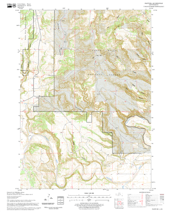
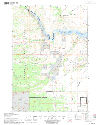
Flint Hill Quadrangle, South Dakota
United States Department of Agriculture Forest Service
United States Department of Agriculture Forestry Service topographical map of Flint Hill, Black Hills National Forest, South Dakota.
Page Size: 21.75 x 27 in (552 x 686 mm)
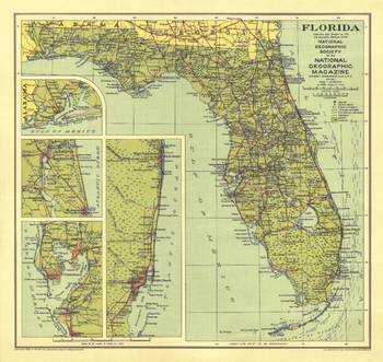
Florida - Published 1930
National Geographic
This Florida map was published in National Geographic Magazine in January 1930 with the article "Florida - The Fountain of Youth." Insets maps provide further detail in this early depiction of the Sunshine State.
Page Size: 13.25 x 12.5 in (333 x 315 mm)
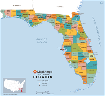
Florida Counties Map - Extra Large
MapSherpa
This map has been created exclusively for MapSherpa, and designed for reference or business use. Clear and clean colors & fonts matched with cartographic research makes this map of Florida Counties Map easily readable and useful. The map shows the 67 counties of Florida and their borders across the Sunshine State.
Page Size: 60 x 55.25 in (1524 x 1401 mm)

Florida Counties Map - Large
MapSherpa
This map has been created exclusively for MapSherpa, and designed for reference or business use. Clear and clean colors & fonts matched with cartographic research makes this map of Florida Counties Map easily readable and useful. The map shows the 67 counties of Florida and their borders across the Sunshine State.
Page Size: 48 x 44.25 in (1219 x 1121 mm)

Florida Counties Map - Standard
MapSherpa
This map has been created exclusively for MapSherpa, and designed for reference or business use. Clear and clean colors & fonts matched with cartographic research makes this map of Florida Counties Map easily readable and useful. The map shows the 67 counties of Florida and their borders across the Sunshine State.
Page Size: 36 x 33.25 in (914 x 841 mm)
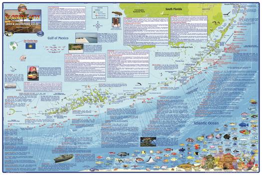
Florida Keys Dive Site Wall Map
Franko Maps
A map of the entire island chain. Dive and snorkel sites are located and described in detail. Also locates and describes parks and other points of interest. Colorful illustrations of 100+ species of reef creatures.
Page Size: 36 x 24 in (914 x 610 mm)
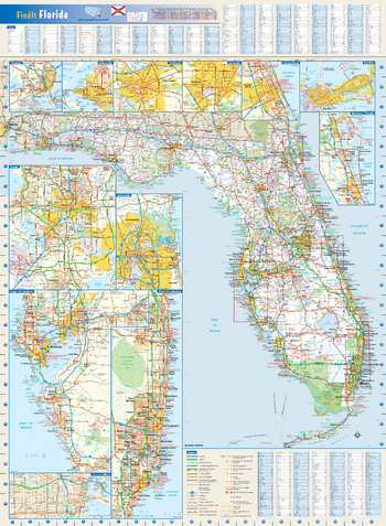
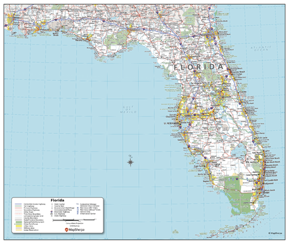
Florida State Wall Map
Globe Turner
This colorful, easy-to-read state map of Florida identifies all major thoroughfares, secondary roads, freeway interchanges, rest areas, distance markers, landmarks, recreational areas, and more. Shaded relief on the state map provides a three-dimensional sense of Florida's topography. Detailed city inset maps of Daytona Beach, Gainesville, Jacksonville, Key West, Melbourne/Titusville, Miami/Fort Lauderdale, Orlando, Panama City, Pensacola, Tallahassee, and Tampa/St. Petersburg are based on the latest street information from our cartographic experts. An up-to-date inset of downtown Miami provides detailed information on the central business district. County and city indices make it simple to locate even the smallest town.
Page Size: 22 x 30 in (559 x 762 mm)
Florida State Wall Map - Compact
MapSherpa
This detailed wall map of Florida is perfect for both educational and business purposes. The easy-to-read map features vibrant colors and clear labeling of cities, counties, highways, and geographical features. All national and state highways that connect the state are all clearly labelled on the map, while the legend notes the different road and land use classifications such as urban, park, military, and many more. The boundaries of each county in the state are defined and named clearly. Whether you are a student, teacher, business person or geography enthusiast, this map is a valuable addition to any space.
Page Size: 19 x 16 in (483 x 406 mm)
Florida State Wall Map - Extra Large
MapSherpa
This detailed wall map of Florida is perfect for both educational and business purposes. The easy-to-read map features vibrant colors and clear labeling of cities, counties, highways, and geographical features. All national and state highways that connect the state are all clearly labelled on the map, while the legend notes the different road and land use classifications such as urban, park, military, and many more. The boundaries of each county in the state are defined and named clearly. Whether you are a student, teacher, business person or geography enthusiast, this map is a valuable addition to any space.
Page Size: 60 x 40 in (1524 x 1016 mm)
Florida State Wall Map - Large
MapSherpa
This detailed wall map of Florida is perfect for both educational and business purposes. The easy-to-read map features vibrant colors and clear labeling of cities, counties, highways, and geographical features. All national and state highways that connect the state are all clearly labelled on the map, while the legend notes the different road and land use classifications such as urban, park, military, and many more. The boundaries of each county in the state are defined and named clearly. Whether you are a student, teacher, business person or geography enthusiast, this map is a valuable addition to any space.
Page Size: 48 x 32 in (1219 x 813 mm)
Florida State Wall Map - Poster
MapSherpa
This detailed wall map of Florida is perfect for both educational and business purposes. The easy-to-read map features vibrant colors and clear labeling of cities, counties, highways, and geographical features. All national and state highways that connect the state are all clearly labelled on the map, while the legend notes the different road and land use classifications such as urban, park, military, and many more. The boundaries of each county in the state are defined and named clearly. Whether you are a student, teacher, business person or geography enthusiast, this map is a valuable addition to any space.
Page Size: 29 x 24.5 in (737 x 622 mm)
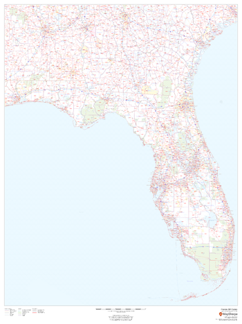
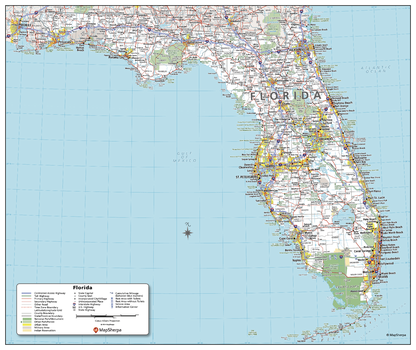
Florida ZIP Code Map
MapSherpa
This map of Florida shows ZIP codes overlaid on a road map. Base map features include county boundaries, major road network features, and state and national parks and conservation areas.
Page Size: 36 x 48 in (914 x 1219 mm)

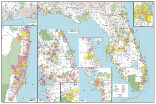
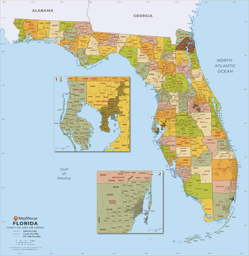
Florida ZIP Code Map with Counties - Extra Large
MapSherpa
This map has been created exclusively for MapSherpa, and designed for business or reference use. Clear and clean colors & fonts matched with cartographic research makes this Florida Zip Code Map with Counties easily readable and useful. The map shows the 67 counties of Florida and the borders of the over 900 zip codes across the Sunshine State.
Page Size: 60 x 62 in (1524 x 1569 mm)
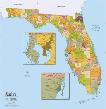
Florida ZIP Code Map with Counties - Large
MapSherpa
This map has been created exclusively for MapSherpa, and designed for business or reference use. Clear and clean colors & fonts matched with cartographic research makes this Florida Zip Code Map with Counties easily readable and useful. The map shows the 67 counties of Florida and the borders of the over 900 zip codes across the Sunshine State.
Page Size: 48 x 49.5 in (1219 x 1255 mm)
Florida ZIP Code Map with Counties - Standard
MapSherpa
This map has been created exclusively for MapSherpa, and designed for business or reference use. Clear and clean colors & fonts matched with cartographic research makes this Florida Zip Code Map with Counties easily readable and useful. The map shows the 67 counties of Florida and the borders of the over 900 zip codes across the Sunshine State.
Page Size: 36 x 37.25 in (914 x 941 mm)
Fly Creek Quadrangle, Oregon
United States Department of Agriculture Forest Service
United States Department of Agriculture Forestry Service topographical map of Fly Creek, Deschutes National Forest, Oregon.
Page Size: 21.75 x 27 in (552 x 686 mm)
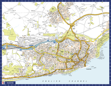
Folkestone A-Z Street Map
A-Z Maps
The perfect reference map for finding your way around Folkstone. This up-to-date detailed A-Z town plan includes more than 1,000 streets in and around Folkestone. Detailed coverage of an area extending from Hawkinge to Sandgate in the south, and from East Wear Bay in the east to Newington in the west. The highly detailed 1 mile to 4.5 inch street map includes places of interest, among other features.
Page Size: 28.5 x 22.25 in (718 x 560 mm)
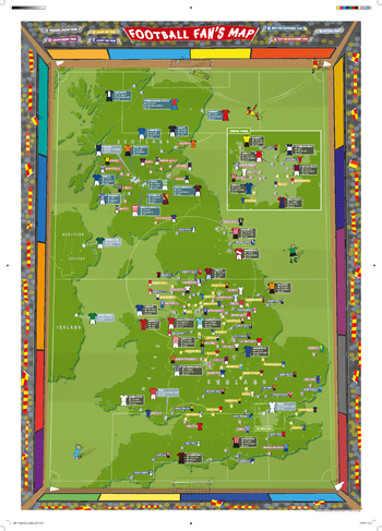
Football Fan's Stadium Map
Maps International
Our Football Fan's Stadium Map Poster is the perfect gift for football fans. Fully updated for the 2016/17 season. Shows the location of stadiums of all the Premier League, Championship, League One and Two clubs plus the Scottish Premiership and Championship stadiums. UK national stadiums are also shown such as Wembley and Hampden Park. Its bright colours look great in children's bedrooms, playrooms and in classrooms. Title will read 'FOOTBALL FAN'S MAP' with red title banner. Scarves are red and yellow.
Page Size: 23.5 x 33.25 in (594 x 841 mm)
No search results