


MapSherpa Catalog
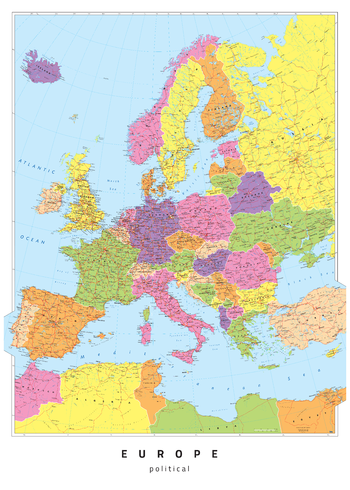
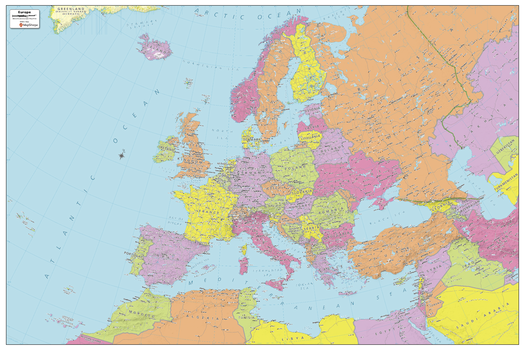
Europe Political
Oxford Cartographers
Europe map, politically coloured
Page Size: 23.5 x 33.25 in (594 x 841 mm)
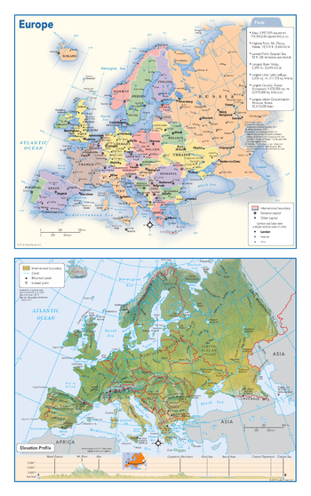
Europe Political & Physical Continent Map
Globe Turner
This map of the European continent combines two maps in one - a vivid political map of Europe showing all of the countries and major cities as well as a colorful topographic physical map depicting all of the major physical features in Europe, including a cross-continent elevation profile. The political map includes a call-out box with interesting facts about the continent.
Page Size: 10.75 x 17 in (271 x 432 mm)
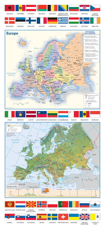
Europe Political & Physical Continent Map with Country Flags
Globe Turner
This map of the European continent combines two maps in one - a vivid political map of Europe showing all of the countries and major cities as well as a colorful topographic physical map depicting all of the major physical features in Europe, including a cross-continent elevation profile. The political map includes a call-out box with interesting facts about the continent. The map also includes all 45 flags each European country.
Page Size: 10.75 x 23.25 in (271 x 587 mm)
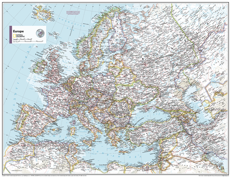
Europe Political - Atlas of the World, 10th Edition
National Geographic
null
Page Size: 28 x 22 in (711 x 559 mm)
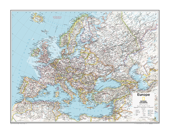
Europe Political - Atlas of the World, 11th Edition
National Geographic
This map of political features can fit in any space. Showcasing Europe in stunning detail with state-of-the-art cartographic techniques delivering accuracy and exceptional quality, the innovative and engaging design makes the content easily accessible and user-friendly.
Ideal for classrooms with an emphasis on teaching geography or environmental themes. The inclusion of physical features on this map gives your students a genuine feel for how our world appears.
This political map of Europe uses a bright, easy to read color palette featuring blue oceans and stunning shaded relief that has been featured on National Geographic wall maps for over 75 years. Drawn in the Azimuthal Equidistant projection, this map ensures that all points are at proportionally correct distances from the center point.
Names of geographic features such as international boundaries, cities, rivers and lakes are carefully placed on the map to maintain legibility.
This map is found in National Geographic's 11th Edition World Atlas and is now available as a stand alone product.
Page Size: 31.5 x 24 in (798 x 610 mm)

Europe Political - Atlas of the World, 11th Edition - Compact
National Geographic
This map of political features can fit in any space. Showcasing Europe in stunning detail with state-of-the-art cartographic techniques delivering accuracy and exceptional quality, the innovative and engaging design makes the content easily accessible and user-friendly.
Ideal for classrooms with an emphasis on teaching geography or environmental themes. The inclusion of physical features on this map gives your students a genuine feel for how our world appears.
This political map of Europe uses a bright, easy to read color palette featuring blue oceans and stunning shaded relief that has been featured on National Geographic wall maps for over 75 years. Drawn in the Azimuthal Equidistant projection, this map ensures that all points are at proportionally correct distances from the center point.
Names of geographic features such as international boundaries, cities, rivers and lakes are carefully placed on the map to maintain legibility.
This map is found in National Geographic's 11th Edition World Atlas and is now available as a stand alone product.
Page Size: 21.5 x 16.25 in (540 x 413 mm)
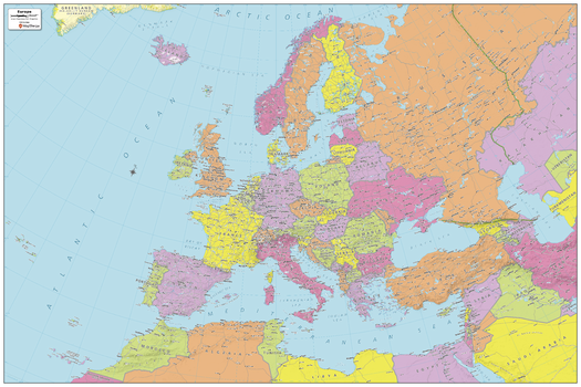
Europe Political Map
MapSherpa
Explore the continent of Europe with this map created specifically for MapSherpa. New and up-to-date, this Map shows all the countries that make up the continent. Stretching from the Atlantic Ocean in the west to Arctic Circle and beyond, to the Ural Mountains and the Mediterranean Sea, this map prominently shows; national capitals, primary cities & towns, primary water features, mountain ranges and all time zones. With this map you can clearly see that some countries straddle both Europe and Asia! With multiple sizes available, this is the perfect reference map for home, office, or school use.
Page Size: 36 x 24 in (914 x 610 mm)
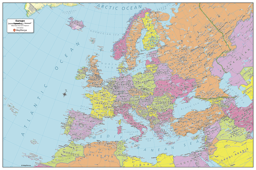
Europe Political Map - Compact
MapSherpa
Explore the continent of Europe with this map created specifically for MapSherpa. New and up-to-date, this Map shows all the countries that make up the continent. Stretching from the Atlantic Ocean in the west to Arctic Circle and beyond, to the Ural Mountains and the Mediterranean Sea, this map prominently shows; national capitals, primary cities & towns, primary water features, mountain ranges and all time zones. With this map you can clearly see that some countries straddle both Europe and Asia! With multiple sizes available, this is the perfect reference map for home, office, or school use.
Page Size: 24.25 x 16.25 in (610 x 407 mm)
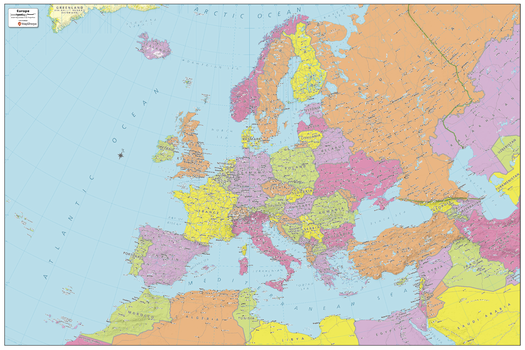
Europe Political Map - Extra Large
MapSherpa
Explore the continent of Europe with this map created specifically for MapSherpa. New and up-to-date, this Map shows all the countries that make up the continent. Stretching from the Atlantic Ocean in the west to Arctic Circle and beyond, to the Ural Mountains and the Mediterranean Sea, this map prominently shows; national capitals, primary cities & towns, primary water features, mountain ranges and all time zones. With this map you can clearly see that some countries straddle both Europe and Asia! With multiple sizes available, this is the perfect reference map for home, office, or school use.
Page Size: 60 x 40 in (1524 x 1016 mm)
Europe Political Map - Large
MapSherpa
Explore the continent of Europe with this map created specifically for MapSherpa. New and up-to-date, this Map shows all the countries that make up the continent. Stretching from the Atlantic Ocean in the west to Arctic Circle and beyond, to the Ural Mountains and the Mediterranean Sea, this map prominently shows; national capitals, primary cities & towns, primary water features, mountain ranges and all time zones. With this map you can clearly see that some countries straddle both Europe and Asia! With multiple sizes available, this is the perfect reference map for home, office, or school use.
Page Size: 48 x 32 in (1219 x 813 mm)
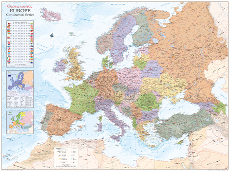
Europe Political Wall Map
Global Mapping
Political map of Europe overlaid on a shanded relief, with information panels on the European Union, language, time zones, international dialling codes and 2004 population estimates. Map features include cities and towns, peaks, airports and major road and railway network features.
Page Size: 53 x 39.5 in (1340 x 1000 mm)
Europe Political Wallpaper
Maps International
This politically coloured map of Europe features countries marked in different colours, with international boundaries shown. All major towns and cities of Europe are featured, and the countries capital cities are clearly marked. The map contains hill and sea shading adding to the vibrant overall effect.
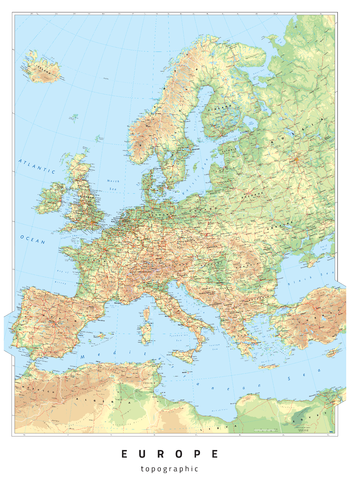
Europe Topographic
Oxford Cartographers
Europe map, with coloured land height layers
Page Size: 23.5 x 33.25 in (594 x 841 mm)
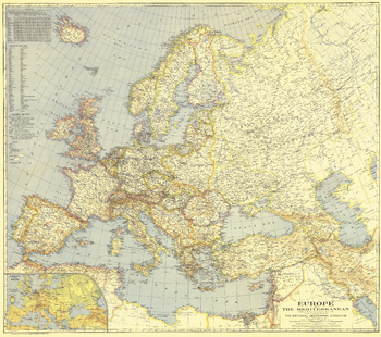
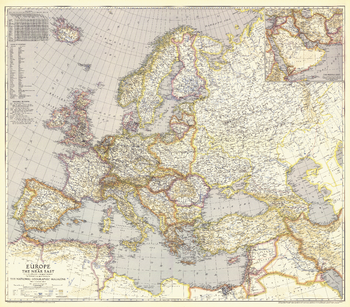
Europe and the Mediterranean - Published 1938
National Geographic
Published in April 1938, this map of Europe and the Mediterranean is a snapshot of the region prior to World War II. A unique feature of this map and others of its era is the list of country names in English as well as the national language.
Page Size: 38.25 x 34 in (968 x 857 mm)
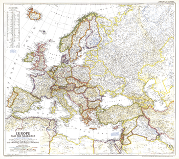
Europe and the Near East - Published 1940
National Geographic
Published in May 1940, this map of Europe and the Near East shows international boundaries as of April 1, 1940. An inset of the Middle East provides detail of the Asian countries adjacent to Europe.
Page Size: 38.75 x 34 in (979 x 863 mm)
Europe and the Near East - Published 1949
National Geographic
A striking rendering of post-war Europe, this map is unique in its lack of ocean color. Colorful borders leap off the white page projecting an optimistic tone. Published in June 1949 with the article "Italy Smiles Again," this map shows American, British, French, and Russian occupational zones in Germany and Austria.
Page Size: 32 x 28.5 in (808 x 718 mm)
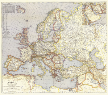
Europe, and the Near East - Published 1943
National Geographic
Published in June 1943, this map of Europe and the Near East features distances from European ports to other world ports. An inset of the Middle East provides detail of the Asian countries adjacent to Europe.
Page Size: 38.75 x 34 in (983 x 862 mm)
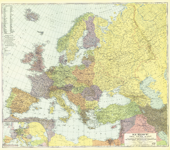
Europe, and the Near East - Published 1929
National Geographic
This colorful map was published in December 1929 with three articles on Europe and the Near East including "The Danube, Highway of Races." An inset map of airways is included, showing commercial air travel in its infancy.
Page Size: 38.5 x 34.25 in (977 x 864 mm)
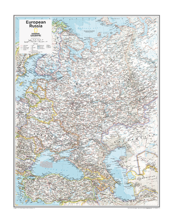
European Russia - Atlas of the World, 10th Edition
National Geographic
Belarus, Russia, Ukraine
Page Size: 22 x 28 in (559 x 711 mm)
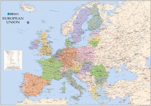
European Union 2017 Wall Map
XYZ Maps
The European Union 2017 Political wall map is ideal for the office or educational environment. This EU map features political colouring showing Europe and the member countries of the European Union. All major Towns, Roads, Rivers and Lakes are shown on this map. This map shows the 2017 membership of the EU.
Page Size: 47 x 33.25 in (1189 x 841 mm)
No search results