


MapSherpa Catalog
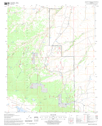
Elliott Canyon Quadrangle, Arizona
United States Department of Agriculture Forest Service
United States Department of Agriculture Forestry Service topographical map of Elliott Canyon, Coconino National Forest, Arizona.
Page Size: 21.75 x 27 in (552 x 686 mm)
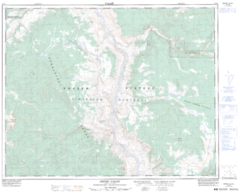
Empire Valley - 92 O/8 - British Columbia
Natural Resources Canada
Canadian topographic map of Empire Valley, British Columbia. NTS sheet 092O08 Edition 4.
Page Size: 31.75 x 25.5 in (804 x 643 mm)
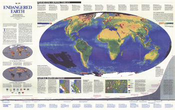
Endangered Earth - Published 1988
National Geographic
This amazing map introduces the issues and challenges surrounding our Endangered Earth as we navigate a historical transition between a world inherited and one profoundly different -- a global biosphere whose vital functions we have altered. Published in December 1988, on the 100th anniversary of the National Geographic Society.
Page Size: 46 x 29.25 in (1166 x 737 mm)
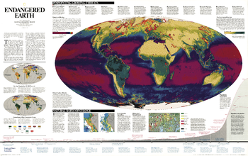
Endangered Earth - Published 1997
National Geographic
We are in a historical transition between a world inherited and one that is profoundly different a global biosphere whose vital functions we have altered. Burgeoning human numbers have placed unprecedented demands on farmland, forests, and other resources, changing the continents green skins of vegetation, as well as the interactions between atmosphere, land, oceans, and living organisms that sustain life on earth. This map shows these interactions and pinpoints growing threats. A wonderful resource for learning more about the delicate balance between development and natural regeneration of the planet.
Page Size: 46.25 x 29 in (1171 x 736 mm)
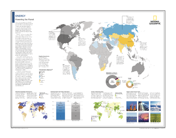
Energy: Powering the Planet - Atlas of the World, 10th Edition
National Geographic
Mapping Energy Sources; Balancing Consumption and Production; Identifying Global Final Energy Consumption; Renewables as a Share of Total Energy Consumption; Growth in Renewable Energy; Toward a Cleaner Energy Supply
Page Size: 28 x 22 in (711 x 559 mm)

Enfield - EN - Postcode Wall Map
XYZ Maps
The Enfield Postcode Sector Wall Map shows detailed postcode sector boundaries (EN1 1, EN1 2) on a comprehensive background and is perfect for determining postcode boundaries for sales areas, planning mailshots and also an excellent reference for logistics. This wall map covers the whole of the EN Postcode Area.
Page Size: 47 x 33.25 in (1189 x 841 mm)
Enfield Quadrangle, New Hampshire-Vermont
United States Department of Agriculture Forest Service
United States Forestry Service topographical map of Enfield, New Hampshire-Vermont
Page Size: 21.75 x 27 in (552 x 686 mm)
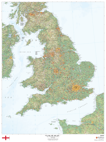
England
MapSherpa
This beautiful map shows physical and political features for England and surrounding areas. Relief shading and the use of different colours by height above sea level are both informative and attractive.
Page Size: 36 x 48 in (914 x 1219 mm)

England & Wales Postcode District Wall Map (D9)
XYZ Maps
The England & Wales Postcode District Map clearly shows postcode district boundaries and associated district labels (SL1, SL2) on a comprehensive background and is perfect for determining postcode boundaries for sales territories, logistics, planning mailshots or as a regional reference guide.
Page Size: 47 x 33.25 in (1189 x 841 mm)
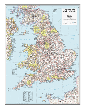
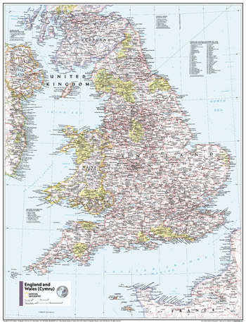
England and Wales (Cymru) - Atlas of the World, 10th Edition
National Geographic
null
Page Size: 21 x 27 in (533 x 686 mm)

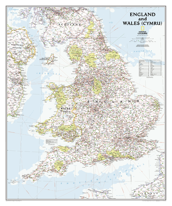
England and Wales (Cymru) - Atlas of the World, 11th Edition
National Geographic
This England and Wales (Cymru) map of physical and political features can fit in any space. Showcasing the country and surrounding regions in stunning detail with state-of-the-art cartographic techniques delivering accuracy and exceptional quality, the innovative and engaging design makes the content easily accessible and user-friendly.
Ideal for classrooms with an emphasis on teaching geography or environmental themes. Physical maps give your students a genuine feel for how our world appears.
This map uses a bright, easy to read color palette featuring blue oceans and stunning shaded relief that has been featured on National Geographic wall maps for over 75 years. It is drawn in a Polyconic projection, where the parallels are all non-concentric circular arcs.
Names of geographic features are carefully placed on the map to maintain legibility. Details on the counties and unitary authorities add details to this classic map.
This map is found in National Geographic's 11th Edition World Atlas and is now available as a stand alone product.
Page Size: 24 x 31.5 in (610 x 798 mm)
England and Wales (Cymru) - Atlas of the World, 11th Edition - Compact
National Geographic
This England and Wales (Cymru) map of physical and political features can fit in any space. Showcasing the country and surrounding regions in stunning detail with state-of-the-art cartographic techniques delivering accuracy and exceptional quality, the innovative and engaging design makes the content easily accessible and user-friendly.
Ideal for classrooms with an emphasis on teaching geography or environmental themes. Physical maps give your students a genuine feel for how our world appears.
This map uses a bright, easy to read color palette featuring blue oceans and stunning shaded relief that has been featured on National Geographic wall maps for over 75 years. It is drawn in a Polyconic projection, where the parallels are all non-concentric circular arcs.
Names of geographic features are carefully placed on the map to maintain legibility. Details on the counties and unitary authorities add details to this classic map.
This map is found in National Geographic's 11th Edition World Atlas and is now available as a stand alone product.
Page Size: 16.25 x 21.5 in (413 x 540 mm)
England and Wales Classic
National Geographic
This classic-style map portrays England and Wales (Cymru) in exceptional detail. It portrays hundreds of place-names—including Welsh and Manx names—transportation networks, and administrative divisions. Each has been carefully researched and accuracy assured by National Geographic's cartographers.<br><br>This map covers all of England and Wales (Cymru), along with parts of Scotland, Northern Ireland, Ireland (Éire), and France.
Page Size: 30 x 36 in (762 x 914 mm)
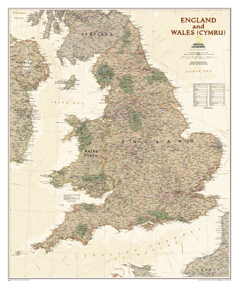
England and Wales Executive
National Geographic
This executive-style map portrays England and Wales (Cymru) in exceptional detail. It portrays hundreds of place-names—including Welsh and Manx names—transportation networks, and administrative divisions. Each has been carefully researched and accuracy assured by National Geographic's cartographers.<br><br>This map covers all of England and Wales (Cymru), along with parts of Scotland, Northern Ireland, Ireland (Éire), and France.
Page Size: 30 x 36 in (762 x 914 mm)
English Mountain Quadrangle, California
United States Department of Agriculture Forest Service
United States Department of Agriculture Forestry Service topographical map of English Mountain, Tahoe National Forest, California.
Page Size: 21.75 x 27 in (552 x 686 mm)
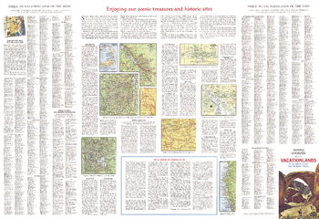
Enjoying Our Scenic Treasures and Historical Sites - Published 1966
National Geographic
A supplement to the Vacationlands of the United States and Canada map, this map includes tips on vacationing and maps of some popular sites. Published in July 1966, it contains information on the variety of scenic and historical sites, from the lure of Indian lands and places where wildlife roam to landmarks of city and industry.
Page Size: 38 x 26 in (962 x 659 mm)
Environmental World Wall Map
Maps International
Maps International's world environmental wall map is a high quality map which is a fantastic representation of the world's environmental terrain and the different environmental categories - tundra, forests, deserts etc. Country borders and major cities are shown. The map's key helps to identify the different land terrain.
Page Size: 53.75 x 33.25 in (1364 x 844 mm)
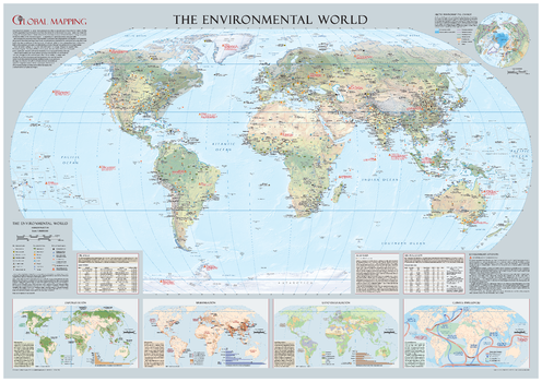
Environmental World Wall Map - Large
Global Mapping
Educational wall map from Global Mapping highlighting the threats human activity has on our planet has picked up two prestigious awards from The British Cartographic Society (BCS). It won the Stanford's Award for Best Paper Map with the judges comments: "Good symbology, size, does the job of clearly conveying the environmental issues facing our planet, a top quality piece of cartography." This informative educational wall map comes from award winning publishers Global Mapping. Pollution (including the devastating BP Deep Horizon Oil Spill in the Gulf of Mexico in 2010-the second worst recorded), Deforestation, Urbanisation, Environment Hotspots, Coastlines at risk from rising sea levels are just some of the topics covered. Beautifully designed by top map designer Mary Spence, MBE, this map makes the perfect companion to 'The Dynamic World'
Page Size: 52.5 x 36.75 in (1333 x 933 mm)
Erie County, New York
MapSherpa
This map of Erie County, New York shows regional level information. Base map features include highways and major roads with labelling; neighborhood names; railways; high level land use such as parks and recreation areas, industrial areas and hospital campuses; and a selection of points of interest including transportation hubs like airports and train stations, tourist information, police stations and shopping centres. ZIP code boundaries are shown as a secondary map feature.
Page Size: 36 x 48 in (914 x 1219 mm)
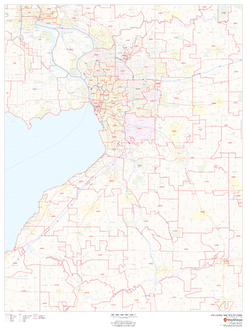
Erie County, New York ZIP Codes
MapSherpa
This map of Erie County, New York shows ZIP code areas overlaid on a road map. Ideal for planning of deliveries, home ervices, sales territories, real estate and much more. Base map features include all roads with major roads and highways labelled; neighborhood names; railways; and high level land use such as parks and recreation areas, industrial areas and hospital campuses.
Page Size: 36 x 48 in (914 x 1219 mm)
No search results