


MapSherpa Catalog
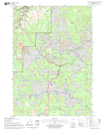
Deadwood South Quadrangle, South Dakota
United States Department of Agriculture Forest Service
United States Department of Agriculture Forestry Service topographical map of Deadwood South, Black Hills National Forest, South Dakota.
Page Size: 21.75 x 27 in (552 x 686 mm)
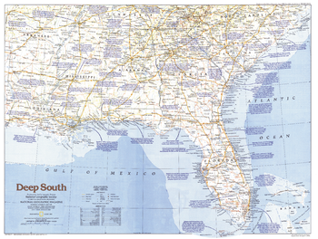
Deep South - Published 1983
National Geographic
Explore the Deep South region of the United States with this informative map, featuring historical notes, fine geographical detail, and a variety of tourist sites. Published in August 1983 as part of the "Making of America" series.
Page Size: 27.25 x 20.5 in (687 x 518 mm)
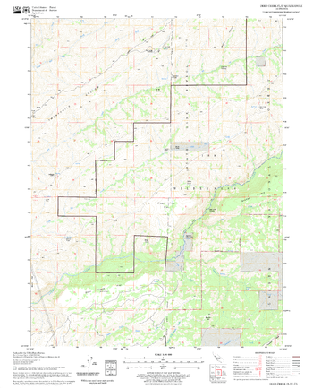
Deer Creek Flat Quadrangle, California
United States Department of Agriculture Forest Service
United States Department of Agriculture Forestry Service topographical map of Deer Creek Flat, Lassen National Forest, California.
Page Size: 21.75 x 27 in (552 x 686 mm)
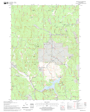
Deerfield Quadrangle, South Dakota
United States Department of Agriculture Forest Service
United States Department of Agriculture Forestry Service topographical map of Deerfield, Black Hills National Forest, South Dakota.
Page Size: 21.75 x 27 in (552 x 686 mm)
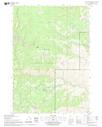
Degan Mountain Quadrangle, Idaho
United States Department of Agriculture Forest Service
United States Department of Agriculture Forestry Service topographical map of Degan Mountain, Salmon-Chalis National Forest, Idaho.
Page Size: 21.75 x 27 in (552 x 686 mm)
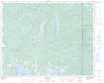
Deka Lake - 92 P/10 - British Columbia
Natural Resources Canada
Canadian topographic map of Deka Lake, British Columbia. NTS sheet 092P10 Edition 2.
Page Size: 31.5 x 25.5 in (799 x 642 mm)
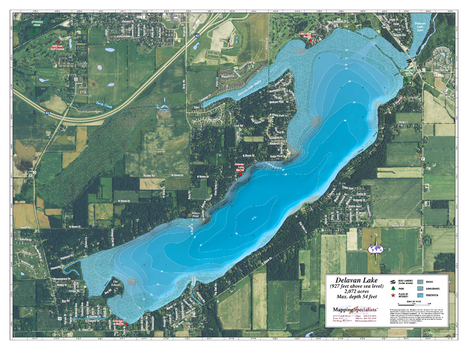
Delavan Lake
Mapping Specialists
An Attractive map of the lake showing a visual 3D representation of the lake bottom. Includes boat launches, rock area and vegetation. Land area is high resolution aerial imagery.
Page Size: 37.25 x 27.75 in (943 x 705 mm)

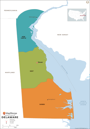
Delaware Counties Map - Extra Large
MapSherpa
This map has been created exclusively for MapSherpa, and designed for reference or business use. Clear and clean colors & fonts matched with cartographic research makes this map of the 3 Delaware counties easily readable and useful.
Page Size: 60 x 85.5 in (1524 x 2170 mm)
Delaware Counties Map - Large
MapSherpa
This map has been created exclusively for MapSherpa, and designed for reference or business use. Clear and clean colors & fonts matched with cartographic research makes this map of the 3 Delaware counties easily readable and useful.
Page Size: 48 x 68.5 in (1219 x 1736 mm)

Delaware Counties Map - Standard
MapSherpa
This map has been created exclusively for MapSherpa, and designed for reference or business use. Clear and clean colors & fonts matched with cartographic research makes this map of the 3 Delaware counties easily readable and useful.
Page Size: 36 x 51.5 in (914 x 1302 mm)
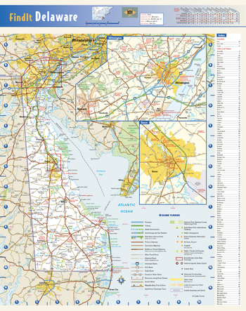
Delaware State Wall Map
Globe Turner
This colorful, easy-to-read state map of Delaware identifies all major thoroughfares, secondary roads, freeway interchanges, rest areas, distance markers, landmarks, recreational areas, and more. Detailed inset maps of Dover and Wilmington are based on the latest street information from our cartographic experts. County and city indices make it simple to locate even the smallest town.
Page Size: 12.25 x 15.5 in (311 x 394 mm)
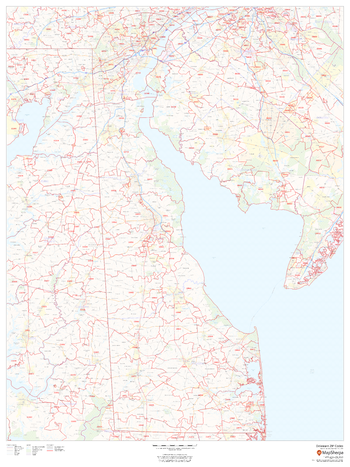
Delaware ZIP Code Map
MapSherpa
This map of Delaware shows ZIP code areas overlaid on a road map. Ideal for planning of deliveries, home services, sales territories, real estate and much more. Base map features include all roads with major roads and highways labelled; municipality and county boundaries; neighborhood names; railways; and high level land use such as parks and recreation areas, industrial areas and hospital campuses.
Page Size: 36 x 48 in (914 x 1219 mm)

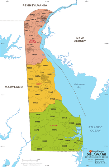
Delaware ZIP Code Map with Counties - Extra Large
MapSherpa
This map has been created exclusively for MapSherpa, and designed for business or reference use. Clear and clean colors & fonts matched with cartographic research makes this map of Delaware's counties and ZIP codes easily readable and useful.
Page Size: 60 x 92 in (1524 x 2333 mm)

Delaware ZIP Code Map with Counties - Large
MapSherpa
This map has been created exclusively for MapSherpa, and designed for business or reference use. Clear and clean colors & fonts matched with cartographic research makes this map of Delaware's counties and ZIP codes easily readable and useful.
Page Size: 48 x 73.5 in (1219 x 1867 mm)
Delaware ZIP Code Map with Counties - Standard
MapSherpa
This map has been created exclusively for MapSherpa, and designed for business or reference use. Clear and clean colors & fonts matched with cartographic research makes this map of Delaware's counties and ZIP codes easily readable and useful.
Page Size: 36 x 55.25 in (914 x 1400 mm)
Delectable Mountain Quadrangle, New Hampshire-Vermont
United States Department of Agriculture Forest Service
United States Forestry Service topographical map of Delectable Mountain, New Hampshire-Vermont
Page Size: 21.75 x 27 in (552 x 686 mm)
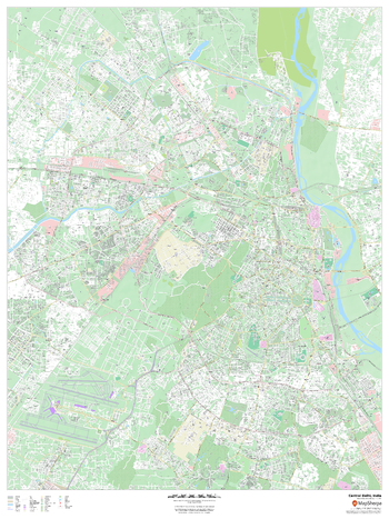
Delhi, India Inner Metro
MapSherpa
This detailed street map of central Delhi, India shows the full road and rail networks, points of interest, and land use across the city. Useful for businesses operating in the city, or as consumer memorabilia of the city.
Page Size: 36 x 48 in (914 x 1219 mm)
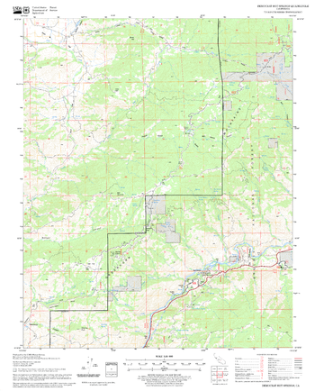
Democrat Hot Springs Quadrangle, California
United States Department of Agriculture Forest Service
United States Department of Agriculture Forestry Service topographical map of Democrat Hot Springs, Sequoia National Forest, California.
Page Size: 21.75 x 27 in (552 x 686 mm)
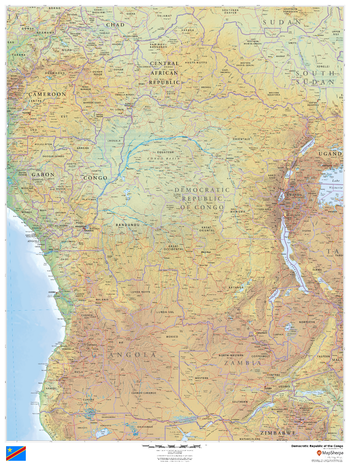
Democratic Republic of the Congo
MapSherpa
This beautiful map shows physical and political features for Democratic Republic of the Congo and surrounding areas. Relief shading and the use of different colours by height above sea level are both informative and attractive.
Page Size: 36 x 48 in (914 x 1219 mm)
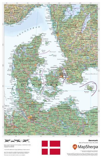
Denmark
MapSherpa
This beautiful map shows physical and political features for Denmark and surrounding areas. Relief shading and the use of different colours by height above sea level are both informative and attractive.
Page Size: 11 x 17 in (279 x 432 mm)
No search results