MapSherpa Catalog

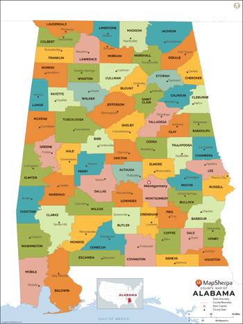
Alabama Counties Map - Large
MapSherpa
This map has been created exclusively for MapSherpa, and designed for reference or business use. Clear and clean colors & fonts matched with cartographic research makes this map of the 67 Alabama counties easily readable and useful.
Page Size: 48 x 64 in (1219 x 1622 mm)
Alabama Counties Map - Standard
MapSherpa
This map has been created exclusively for MapSherpa, and designed for reference or business use. Clear and clean colors & fonts matched with cartographic research makes this map of the 67 Alabama counties easily readable and useful.
Page Size: 36 x 48 in (914 x 1217 mm)
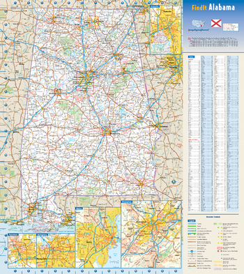
Alabama State Wall Map
Globe Turner
This colorful, easy-to-read state map of Alabama identifies all major thoroughfares, secondary roads, freeway interchanges, rest areas, distance markers, landmarks, recreational areas, and more. Shaded relief on the state map provides a three-dimensional sense of Alabama’s topography. Detailed inset maps of Birmingham, Huntsville, Mobile, Montgomery, and Tuscaloosa are based on the latest street information from our cartographic experts. County and city indices make it simple to locate even the smallest town.
Page Size: 18.5 x 20.75 in (467 x 524 mm)
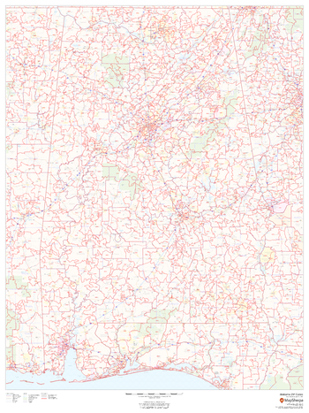
Alabama ZIP Code Map
MapSherpa
This map of Alabama shows ZIP codes overlaid on a road map. Base map features include municipality and county boundaries, major road network features, and state and national parks and conservation areas.
Page Size: 36 x 48 in (914 x 1219 mm)

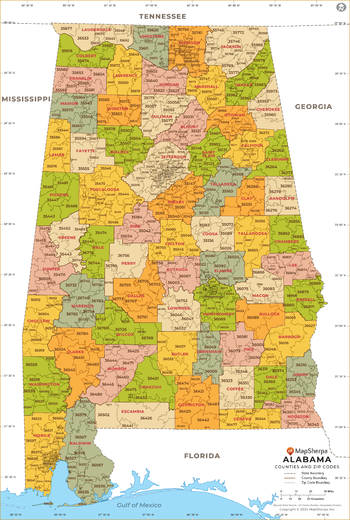
Alabama ZIP Code Map with Counties - Extra Large
MapSherpa
This map has been created exclusively for MapSherpa, and designed for business or reference use. Clear and clean colors & fonts matched with cartographic research makes this map of Alabama's counties and ZIP codes easily readable and useful.
Page Size: 60 x 89.25 in (1524 x 2266 mm)
Alabama ZIP Code Map with Counties - Large
MapSherpa
This map has been created exclusively for MapSherpa, and designed for business or reference use. Clear and clean colors & fonts matched with cartographic research makes this map of Alabama's counties and ZIP codes easily readable and useful.
Page Size: 48 x 71.5 in (1219 x 1813 mm)

Alabama ZIP Code Map with Counties - Standard
MapSherpa
This map has been created exclusively for MapSherpa, and designed for business or reference use. Clear and clean colors & fonts matched with cartographic research makes this map of Alabama's counties and ZIP codes easily readable and useful.
Page Size: 36 x 53.75 in (914 x 1360 mm)
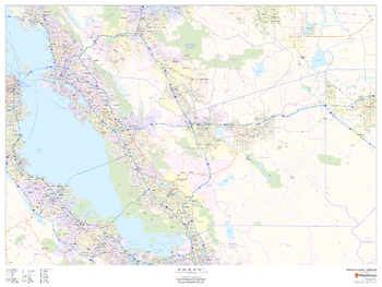
Alameda County, California
MapSherpa
This map of Alameda County, California shows regional level information. Base map features include highways and major roads with labelling; neighborhood names; railways; high level land use such as parks and recreation areas, industrial areas and hospital campuses; and a selection of points of interest including transportation hubs like airports and train stations, tourist information, police stations and shopping centres. ZIP code boundaries are shown as a secondary map feature.
Page Size: 48 x 36 in (1219 x 914 mm)
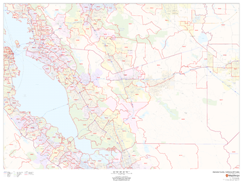
Alameda County, California ZIP Codes
MapSherpa
This map of Alameda County, California shows ZIP code areas overlaid on a road map. Ideal for planning of deliveries, home services, sales territories, real estate and much more. Base map features include all roads with major roads and highways labelled; neighborhood names; railways; and high level land use such as parks and recreation areas, industrial areas and hospital campuses.
Page Size: 48 x 36 in (1219 x 914 mm)
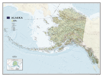
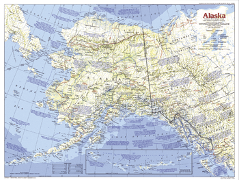
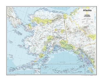
Alaska
National Geographic
One of the largest and most detailed maps available for the North Star State. Rich shaded relief makes Alaska's incredibly diverse terrain easy to visualize and remarkably beautiful.<br><br>The map includes hundreds of named places including primary and secondary towns, political boundaries, infrastructure, hydrography, national parks, state parks, wilderness areas, major peaks, military reservations, and more. It shows Alaska in its entirety, including the entire 2,200 mile Aleutian Island chain that when mapping it in detail, cartographers almost always break it into sections for convenience. This map, however, portrays the entire State at the same scale on one wide sheet – offering an unparalleled perspective on Alaska's true size. Also found on the map is an inset map, in the lower left-hand corner, which displays Alaska's relative size to the conterminous U.S.
Page Size: 40.5 x 30.25 in (1029 x 768 mm)
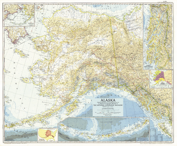
Alaska - Published 1956
National Geographic
This Alaska map features several detailed insets of such areas as the Inside Passage and the Aleutian Islands. A relative size comparison of Alaska and the United States demonstrates that if the state's westernmost point were superimposed on the California coast, its easternmost point would be on the east coast of South Carolina. Published in June 1956 in the same year that Alaska, then a territory of the United States, ratified its constitution.
Page Size: 35 x 29 in (887 x 733 mm)
Alaska - Published 1984
National Geographic
The largest state in the United States, Alaska is home to some of the most pristine wilderness in the world. Explore the region with this informative map, featuring attractive mountain relief and a wealth of historical notes. Published in 1984 as part of the "Making of America" series.
Page Size: 27.25 x 20.5 in (686 x 516 mm)
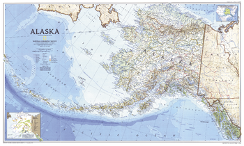
Alaska - Published 1994
National Geographic
Cartographers usually break Alaska up into sections, but this unique map shows all of the state, more than 2,200 miles from the tip of the panhandle to the outermost Aleutian Island, in the same scale on one, wide sheet. Published in May 1994.
Page Size: 37 x 22.25 in (935 x 560 mm)
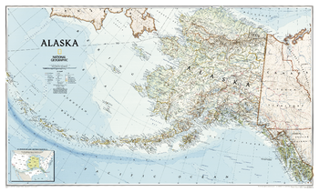
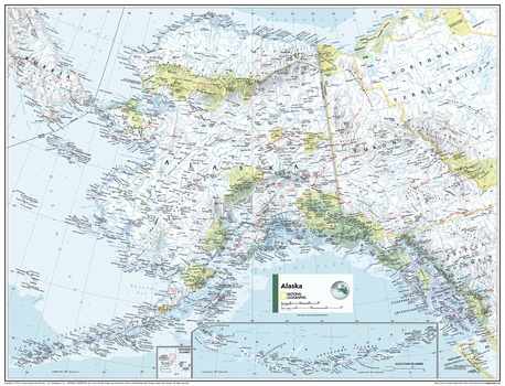
Alaska - Published 2002
National Geographic
One of the most beautiful maps of Alaska ever published, this map covers the entire breadth of this northern U.S. state, from the Inside Passage in the southeast, to Point Barrow in the North, and along the entire span of the Aleutian Islands. Artful cartography reveals national parks, mountain ranges, wildlife refuges, and preserves.
Page Size: 37.5 x 22.75 in (951 x 572 mm)
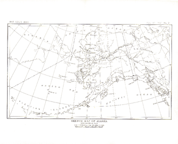
Alaska - Published 1891
National Geographic
This antique sketch map of Alaska was published in 1891 with the article "The Southern Coast of Alaska." One of several early maps of what would become the 49th state in Union, this work makes a fine companion for the Muir Glacier map of 1892.
Page Size: 12.25 x 10 in (307 x 249 mm)
Alaska - Atlas of the World, 10th Edition
National Geographic
Page Size: 28 x 22 in (711 x 559 mm)
Alaska - Atlas of the World, 11th Edition
National Geographic
This Alaska map of physical and political features can fit in any space. Showcasing the region in stunning detail with state-of-the-art cartographic techniques delivering accuracy and exceptional quality, the innovative and engaging design makes the content easily accessible and user-friendly.
Ideal for classrooms with an emphasis on teaching geography or environmental themes. Physical maps give your students a genuine feel for how our world appears.
This map uses a bright, easy to read color palette featuring blue oceans and stunning shaded relief that has been featured on National Geographic wall maps for over 75 years. Drawn in the Azimuthal Equidistant projection, this map ensures that all points on the map are at proportionally correct distances from the center point.
This map is found in National Geographic's 11th Edition World Atlas and is now available as a stand alone product.
Page Size: 31.5 x 24 in (798 x 610 mm)

Alaska - Atlas of the World, 11th Edition - Compact
National Geographic
This Alaska map of physical and political features can fit in any space. Showcasing the region in stunning detail with state-of-the-art cartographic techniques delivering accuracy and exceptional quality, the innovative and engaging design makes the content easily accessible and user-friendly.
Ideal for classrooms with an emphasis on teaching geography or environmental themes. Physical maps give your students a genuine feel for how our world appears.
This map uses a bright, easy to read color palette featuring blue oceans and stunning shaded relief that has been featured on National Geographic wall maps for over 75 years. Drawn in the Azimuthal Equidistant projection, this map ensures that all points on the map are at proportionally correct distances from the center point.
This map is found in National Geographic's 11th Edition World Atlas and is now available as a stand alone product.
Page Size: 21.5 x 16.25 in (540 x 413 mm)
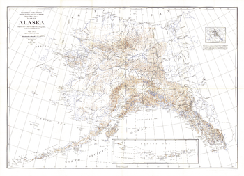
Alaska - Published 1904
National Geographic
This historic map of Alaska shows the region after the boundary was agreed to with Canada. Published in National Geographic Magazine in 1904 with the article "The Geography of Alaska," this map includes an inset showing areas mapped by the U.S. Geological Survey. A wonderful companion to the Alaska Boundary Tribunal map printed the same year.
Page Size: 49.5 x 36 in (1257 x 911 mm)
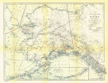
Alaska - Published 1914
National Geographic
Published in February 1914 with the article "The Nation's Undeveloped Resources," the Map of Alaska contains an abundance of details showing the growing human settlement of the region. U.S. public schools for natives, post offices, telegraph stations, mail routes, and mission stations are just some of the many features shown on this map.
Page Size: 21.5 x 16.5 in (545 x 416 mm)
No search results