


MapSherpa Catalog
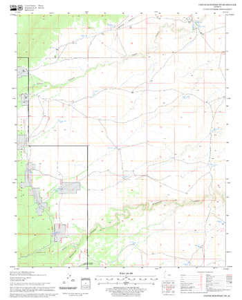
Chavez Mountain NW Quadrangle, Arizona
United States Department of Agriculture Forest Service
United States Department of Agriculture Forestry Service topographical map of Chavez Mountain NW, Coconino National Forest, Arizona.
Page Size: 21.75 x 27 in (552 x 686 mm)
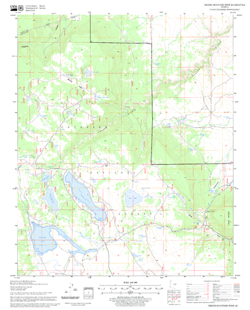
Chavez Mountain West Quadrangle, Arizona
United States Department of Agriculture Forest Service
United States Department of Agriculture Forestry Service topographical map of Chavez Mountain West, Coconino National Forest, Arizona.
Page Size: 21.75 x 27 in (552 x 686 mm)
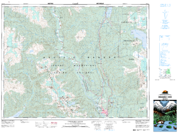
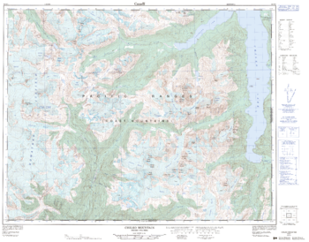
Cheakmus River - 92 G/14 - British Columbia
Natural Resources Canada
Canadian topographic map of Cheakmus River, British Columbia. NTS sheet 092G14 Edition 3.
Page Size: 35.5 x 26.5 in (897 x 669 mm)

Chelmsford - CM - Postcode Wall Map
XYZ Maps
The Chelmsford Postcode Sector Wall Map shows detailed postcode sector boundaries (CH1 1, CH1 2) on a comprehensive background and is perfect for determining postcode boundaries for sales areas, planning mailshots and also an excellent reference for logistics. This wall map covers the whole of the CH Postcode Area.
Page Size: 47 x 33.25 in (1189 x 841 mm)
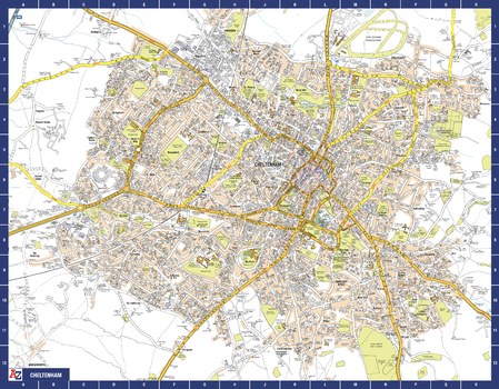
Cheltenham A-Z Street Map
A-Z Maps
The perfect reference map for finding your way around Cheltenham. This up-to-date detailed A-Z town plan includes more than 2,000 streets in and around Cheltenham.
As well as the Cheltenham Racecourse, the other areas covered include Badgeworth, The Reddings, Up Hatherley, Charlton Kings, Montpellier, Battledown, Hayden, Swindon and Prestbury. The highly detailed 1 mile to 5.5 inch street map includes places of interest, among other features.
Page Size: 28.5 x 22.25 in (718 x 560 mm)

Chequamegon Bay
Mapping Specialists
An Attractive map of the lake showing a visual 3D representation of the lake bottom. Includes boat launches, rock area and vegetation. Land area is high resolution aerial imagery.
Page Size: 37.25 x 27.75 in (943 x 705 mm)
Chernivetska oblast Wall Map - Ukrainian
Kartographia
This Ukrainian-language wall map features important architectural sites, monuments, national parks, wildlife areas, nature monuments and tourist centers of Chernivetska oblast. Also included is a place name distance index and photographs and descriptions of points of interest.
Page Size: 38 x 23 in (960 x 580 mm)
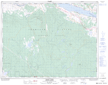
Cherry Creek - 92 I/10 - British Columbia
Natural Resources Canada
Canadian topographic map of Cherry Creek, British Columbia. NTS sheet 092I10 Edition 3.
Page Size: 32.25 x 25.5 in (816 x 643 mm)

Cheshire County Map
XYZ Maps
This is a large ceremonial county map of Cheshire highlighting the county border, with the surrounding area faded out for excellent contrast. The map covers Altrincham, Birkenhead, Chester, Crewe, Halton, Hoylake, Knutsford, Macclesfield, Nantwich, Sale, Stalybridge, Stockport and Wilmslow. The county map shows the latest County and Unitary Authority Boundaries, Overlaid on a Clear and Easy to Read Ordnance Survey map.
Page Size: 47 x 33.25 in (1189 x 841 mm)

Chester - CH - Postcode Wall Map
XYZ Maps
The Chester Postcode Sector Wall Map shows detailed postcode sector boundaries (CH1 1, CH1 2) on a comprehensive background and is perfect for determining postcode boundaries for sales areas, planning mailshots and also an excellent reference for logistics. This wall map covers the whole of the CH Postcode Area.
Page Size: 33.25 x 47 in (841 x 1189 mm)
Chester Quadrangle, California
United States Department of Agriculture Forest Service
United States Department of Agriculture Forestry Service topographical map of Chester, Lassen National Forest, California.
Page Size: 21.75 x 27 in (552 x 686 mm)

Chicago Park Quadrangle, California
United States Department of Agriculture Forest Service
United States Department of Agriculture Forestry Service topographical map of Chicago Park, Tahoe National Forest, California.
Page Size: 21.75 x 27 in (552 x 686 mm)
Chicago, Illinois Inner Metro - Landscape
MapSherpa
This landscape-oriented map of central Chicago, Illinois shows detailed street level information including extensive street labeling. Ideal for planning of deliveries, home services, sales territories, real estate and much more. Base map features include all roads with major roads and highways labelled; neighborhood names; railways; high level land use such as parks and recreation areas, industrial areas and hospital campuses; and a variety of points of interest including schools, libraries, stadiums, museums, border crossings and more.
Page Size: 48 x 36 in (1219 x 914 mm)
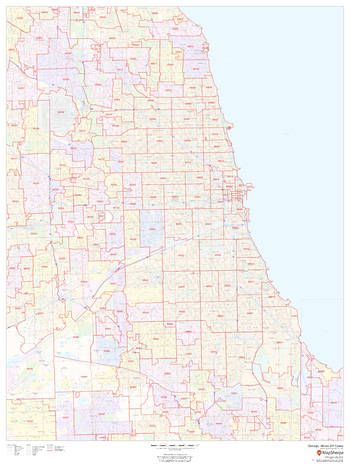
Chicago, Illinois Inner Metro - Portrait
MapSherpa
This portrait-oriented map of central Chicago, Illinois shows detailed street level information including extensive street labeling. Ideal for planning of deliveries, home services, sales territories, real estate and much more. Base map features include all roads with major roads and highways labelled; neighborhood names; railways; high level land use such as parks and recreation areas, industrial areas and hospital campuses; and a variety of points of interest including schools, libraries, stadiums, museums, border crossings and more.
Page Size: 36 x 48 in (914 x 1219 mm)
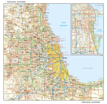
Chicago, Illinois Wall Map, large
Globe Turner
This detailed reference map combines two maps in one - a regional map of the Chicagoland area plus a street-level map of downtown Chicago. The regional map shows the area’s cities and towns, highways and roads, and a variety of points of interest. Joliet, Aurora, Elgin, and Highland Park are among the suburbs near Chicago that are featured on this map. The highly detailed inset of the Chicago central business district shows highways, streets, parks, landmarks, and other points of interest. The Loop, Printer’s Row, Chinatown, and the Near North are among the neighborhoods shown on this map. Also available in a small size of 14.50" high X 15.00" high.
Page Size: 30 x 29 in (762 x 737 mm)
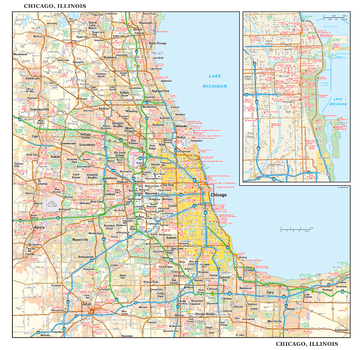
Chicago, Illinois Wall Map, small
Globe Turner
This detailed reference map combines two maps in one - a regional map of the Chicagoland area plus a street-level map of downtown Chicago. The regional map shows the area’s cities and towns, highways and roads, and a variety of points of interest. Joliet, Aurora, Elgin, and Highland Park are among the suburbs near Chicago that are featured on this map. The highly detailed inset of the Chicago central business district shows highways, streets, parks, landmarks, and other points of interest. The Loop, Printer’s Row, Chinatown, and the Near North are among the neighborhoods shown on this map. Also available in a large size of 29.00" high X 30.00" high.
Page Size: 15 x 14.5 in (381 x 368 mm)
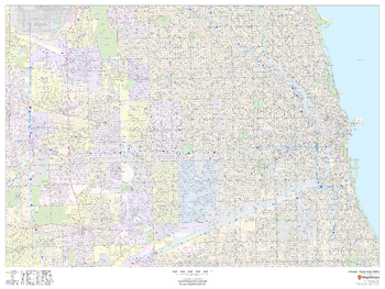
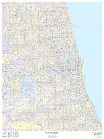
Chicago, Illinois ZIP Codes
MapSherpa
This map of Chicago shows ZIP code areas overlaid on a road map. Ideal for planning of deliveries, home services, sales territories, real estate and much more. Base map features include all roads with major roads and highways labelled; neighborhood names; railways; and high level land use such as parks and recreation areas, industrial areas and hospital campuses.
Page Size: 36 x 48 in (914 x 1219 mm)
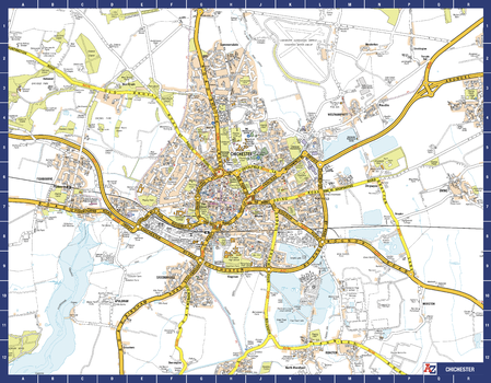
Chichester A-Z Street Map
A-Z Maps
The perfect reference map for finding your way around Chichester. This up-to-date detailed A-Z town plan indexes 780 streets in and around Chichester. As well as the harbour, the other areas covered are Fishbourne, Stockbridge, Whyke and Portfield. The highly detailed 1 mile to 5.5 inch street map includes places of interest, among other features.
Page Size: 28.5 x 22.25 in (718 x 560 mm)
Childs Meadows Quadrangle, California
United States Department of Agriculture Forest Service
United States Department of Agriculture Forestry Service topographical map of Childs Meadows, Lassen National Forest, California.
Page Size: 21.75 x 27 in (552 x 686 mm)
Chilko Mountain - 92 N/1 - British Columbia
Natural Resources Canada
Canadian topographic map of Chilko Mountain, British Columbia. NTS sheet 092N01 Edition 2.
Page Size: 32.5 x 25.5 in (821 x 642 mm)
No search results