


MapSherpa Catalog
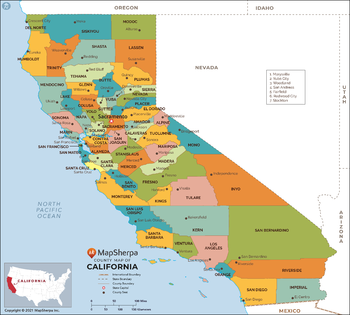
California Counties Map - Standard
MapSherpa
This map has been created exclusively for MapSherpa, and designed for reference or business use. Clear and clean colors & fonts matched with cartographic research makes this map of California Counties Map easily readable and useful. The map shows the 58 counties of California and their borders across the Golden State.
Page Size: 36 x 32.5 in (914 x 823 mm)
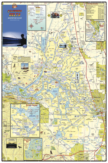
California Delta Waterways Wall Map
Franko Maps
Detailed waterways map of the San Joaquin and Sacramento Rivers. Shows the area from Sacramento on the north to Tracy on the south, and from Stockton on the east to Pittsburg on the west. Insets of Walnut Grove, Bethel Island and Discovery Bay.
Page Size: 24 x 36 in (610 x 914 mm)
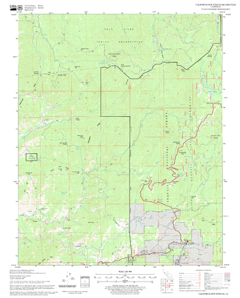
California Hot Springs Quadrangle, California
United States Department of Agriculture Forest Service
United States Department of Agriculture Forestry Service topographical map of California Hot Springs, Sequoia National Forest, California.
Page Size: 21.75 x 27 in (552 x 686 mm)
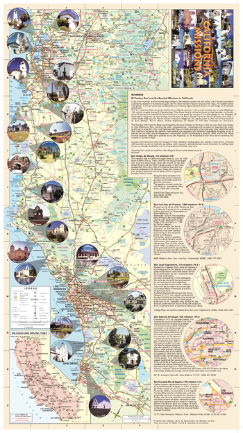
California Missions Map
GM Johnson
California Missions Map. Enlargements of Select Missions. Also Includes: Mileage & Driving Times Map and Descriptive Text of Select Missions.
Page Size: 12.75 x 22.5 in (320 x 571 mm)
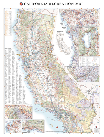
California Recreation Wall Map – 26 inch
Benchmark Maps
Few places in the world can claim such diverse landscapes and seascapes as California. This map illustrates The Golden State’s network of highways that grant road travelers access to iconic natural features like Death Valley, Lake Tahoe, Yosemite Valley, and the Coastal Redwoods to name a few.
Page Size: 26 x 34.5 in (660 x 873 mm)
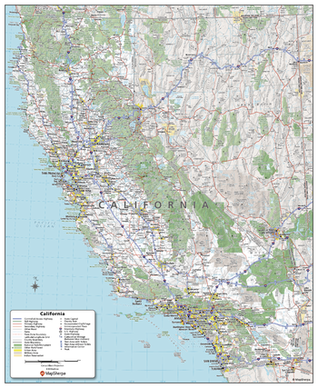
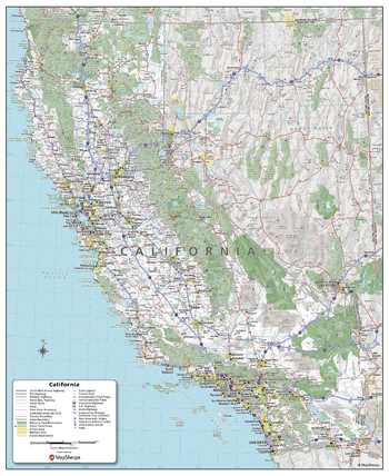
California State Wall Map
Globe Turner
This colorful, easy-to-read state map of California identifies all major thoroughfares, secondary roads, freeway interchanges, distance markers, landmarks, recreational areas, and more. Shaded relief on the state map provides a three-dimensional sense of California’s topography. County and city indices make it simple to locate even the smallest town. City type sizes reflect the 2020 U.S. Census.
Page Size: 19.75 x 23.75 in (502 x 603 mm)
California State Wall Map - Compact
MapSherpa
This detailed wall map of California is perfect for both educational and business purposes. The easy-to-read map features vibrant colors and clear labeling of cities, counties, highways, and geographical features. All national and state highways that connect the state are all clearly labelled on the map, while the legend notes the different road and land use classifications such as urban, park, military, and many more. The boundaries of each county in the state are defined and named clearly. Whether you are a student, teacher, business person or geography enthusiast, this map is a valuable addition to any space.
Page Size: 16 x 19.5 in (406 x 495 mm)

California State Wall Map - Extra Large
MapSherpa
This detailed wall map of California is perfect for both educational and business purposes. The easy-to-read map features vibrant colors and clear labeling of cities, counties, highways, and geographical features. All national and state highways that connect the state are all clearly labelled on the map, while the legend notes the different road and land use classifications such as urban, park, military, and many more. The boundaries of each county in the state are defined and named clearly. Whether you are a student, teacher, business person or geography enthusiast, this map is a valuable addition to any space.
Page Size: 45 x 60 in (1143 x 1524 mm)
California State Wall Map - Large
MapSherpa
This detailed wall map of California is perfect for both educational and business purposes. The easy-to-read map features vibrant colors and clear labeling of cities, counties, highways, and geographical features. All national and state highways that connect the state are all clearly labelled on the map, while the legend notes the different road and land use classifications such as urban, park, military, and many more. The boundaries of each county in the state are defined and named clearly. Whether you are a student, teacher, business person or geography enthusiast, this map is a valuable addition to any space.
Page Size: 36 x 48 in (914 x 1219 mm)
California State Wall Map - Poster
MapSherpa
This detailed wall map of California is perfect for both educational and business purposes. The easy-to-read map features vibrant colors and clear labeling of cities, counties, highways, and geographical features. All national and state highways that connect the state are all clearly labelled on the map, while the legend notes the different road and land use classifications such as urban, park, military, and many more. The boundaries of each county in the state are defined and named clearly. Whether you are a student, teacher, business person or geography enthusiast, this map is a valuable addition to any space.
Page Size: 27 x 33 in (686 x 838 mm)
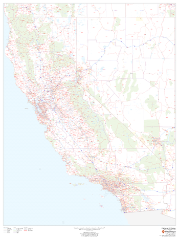
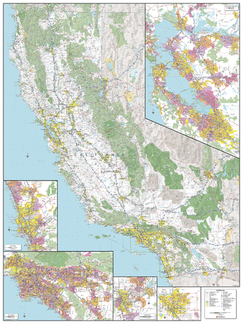
California ZIP Code Map
MapSherpa
This map of California shows ZIP codes overlaid on a road map. Base map features include county boundaries, major road network features, and state and national parks and conservation areas.
Page Size: 36 x 48 in (914 x 1219 mm)

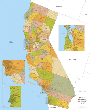
California ZIP Code Map with Counties - Extra Large
MapSherpa
This map has been created exclusively for MapSherpa, and designed for business or reference use. Clear and clean colors & fonts matched with cartographic research makes this California Zip Code Map with Counties easily readable and useful. The map shows the 58 counties of California and the borders of the over 1,700 zip codes across the Golden State.
Page Size: 60 x 73.5 in (1524 x 1865 mm)
California ZIP Code Map with Counties - Large
MapSherpa
This map has been created exclusively for MapSherpa, and designed for business or reference use. Clear and clean colors & fonts matched with cartographic research makes this California Zip Code Map with Counties easily readable and useful. The map shows the 58 counties of California and the borders of the over 1,700 zip codes across the Golden State.
Page Size: 48 x 58.75 in (1219 x 1492 mm)

California ZIP Code Map with Counties - Standard
MapSherpa
This map has been created exclusively for MapSherpa, and designed for business or reference use. Clear and clean colors & fonts matched with cartographic research makes this California Zip Code Map with Counties easily readable and useful. The map shows the 58 counties of California and the borders of the over 1,700 zip codes across the Golden State.
Page Size: 36 x 44.25 in (914 x 1119 mm)
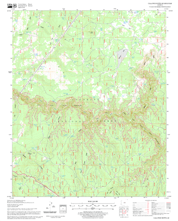
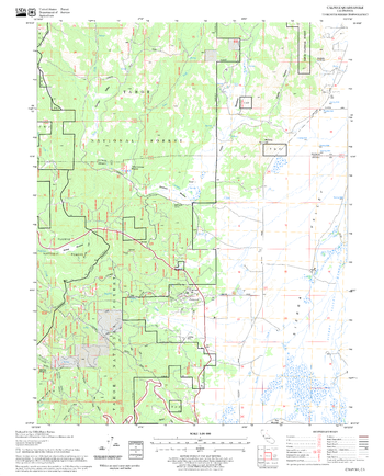
Calloway Butte Quadrangle, Arizona
United States Department of Agriculture Forest Service
United States Department of Agriculture Forestry Service topographical map of Calloway Butte, Coconino National Forest, Arizona.
Page Size: 21.75 x 27 in (552 x 686 mm)
Calpine Quadrangle, California
United States Department of Agriculture Forest Service
United States Department of Agriculture Forestry Service topographical map of Calpine, Tahoe National Forest, California.
Page Size: 21.75 x 27 in (552 x 686 mm)
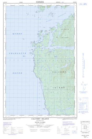
Calvert Island - 102 P/9 E - British Columbia
Natural Resources Canada
Canadian topographic map of Calvert Island, British Columbia. NTS sheet 102P09 E Edition 1.
Page Size: 18.5 x 28 in (466 x 706 mm)
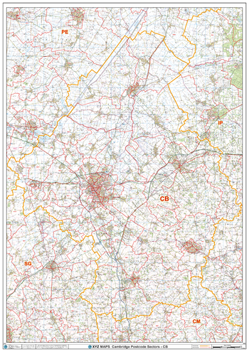
Cambridge - CB - Postcode Wall Map
XYZ Maps
The Cambridge Postcode Sector Wall Map shows detailed postcode sector boundaries (CB1 1, CB1 2) on a comprehensive background and is perfect for determining postcode boundaries for sales areas, planning mailshots and also an excellent reference for logistics. This wall map covers the whole of the CB Postcode Area.
Page Size: 33.25 x 47 in (841 x 1189 mm)
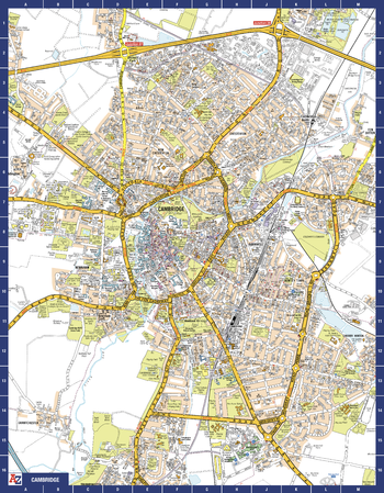
Cambridge A-Z Street Map
A-Z Maps
The perfect reference map for finding your way around Cambridge. This up-to-date detailed A-Z town plan includes more than 1,000 streets in and around Cambridge. As well as the University of Cambridge and Cambridge city centre, other areas covered are Newnham, Barnwell, Cherry Hinton, Chesterton and Cambridge North. The highly detailed 1 mile to 5.5 inch street map includes places of interest, among other features.
Page Size: 22.25 x 28.5 in (560 x 718 mm)

Cambridgeshire County Map
XYZ Maps
This is a large ceremonial county map of Cambridgeshire highlighting the county border, with the surrounding area faded out for excellent contrast. The map covers Burwell, Cambridge, Chatteris, Ely, Gamingley, Melbourne, Sawston, Soham, Wisbech and, Whittlesey. The county map shows the latest County and Unitary Authority Boundaries, Overlaid on a Clear and Easy to Read Ordnance Survey map.
Page Size: 33.25 x 47 in (841 x 1189 mm)
No search results