MapSherpa Catalog
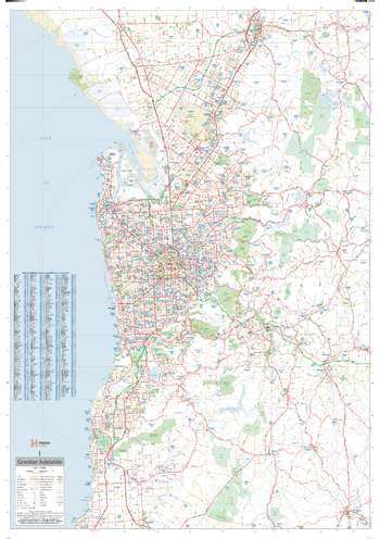
Adelaide Supermap
Hema Maps
A large map of the Greater Adelaide region that is ideal as a reference and for planning sales and delivery zones.
Page Size: 39.5 x 56.25 in (1000 x 1429 mm)
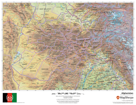
Afghanistan
MapSherpa
This beautiful map shows physical and political features for Afghanistan and surrounding areas. Relief shading and the use of different colours by height above sea level are both informative and attractive.
Page Size: 22 x 17 in (559 x 432 mm)
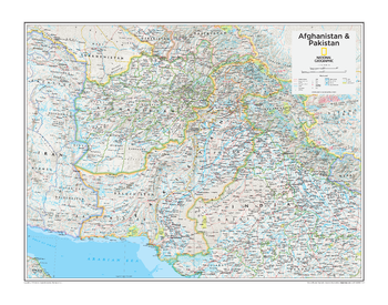
Afghanistan & Pakistan - Atlas of the World, 10th Edition
National Geographic
null
Page Size: 28 x 22 in (711 x 559 mm)
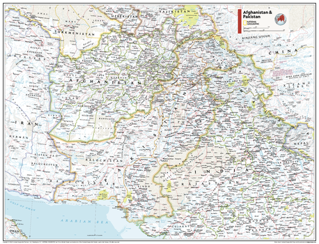
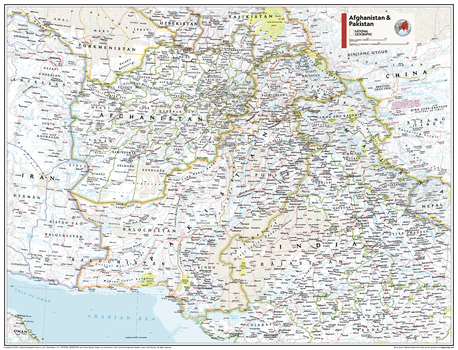
Afghanistan & Pakistan - Atlas of the World, 11th Edition
National Geographic
This Afghanistan and Pakistan map of physical and political features can fit in any space. Showcasing the region in stunning detail with state-of-the-art cartographic techniques delivering accuracy and exceptional quality, the innovative and engaging design makes the content easily accessible and user-friendly.
Ideal for classrooms with an emphasis on teaching geography or environmental themes. The inclusion of physical features gives your students a genuine feel for how our world appears.
This map uses a bright, easy to read color palette featuring blue oceans and stunning shaded relief that has been featured on National Geographic wall maps for over 75 years. It is drawn in the Polyconic projection, where the parallels are all non-concentric circular arcs except for the equator, which is straight.
This map is found in National Geographic's 11th Edition World Atlas and is now available as a stand alone product.
Page Size: 31.5 x 24 in (798 x 610 mm)
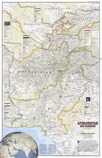
Afghanistan & Pakistan - Atlas of the World, 11th Edition - Compact
National Geographic
This Afghanistan and Pakistan map of physical and political features can fit in any space. Showcasing the region in stunning detail with state-of-the-art cartographic techniques delivering accuracy and exceptional quality, the innovative and engaging design makes the content easily accessible and user-friendly.
Ideal for classrooms with an emphasis on teaching geography or environmental themes. The inclusion of physical features gives your students a genuine feel for how our world appears.
This map uses a bright, easy to read color palette featuring blue oceans and stunning shaded relief that has been featured on National Geographic wall maps for over 75 years. It is drawn in the Polyconic projection, where the parallels are all non-concentric circular arcs except for the equator, which is straight.
This map is found in National Geographic's 11th Edition World Atlas and is now available as a stand alone product.
Page Size: 21.5 x 16.25 in (540 x 413 mm)
Afghanistan and Pakistan - Published 2001
National Geographic
This map of Afghanistan and Pakistan was published just months after the September 11th, 2001 attacks on the United States and on the eve of the US invasion of Afghanistan. At the time of this map's creation, the country was controlled by the Taliban, a radical Islamic movement which had alienated Afghanistan from every neighboring nation with the exception of Pakistan. Published in December 2001 as half of a two–map set with "Afghanistan: Land in Crisis."
Page Size: 20.25 x 31.25 in (514 x 794 mm)
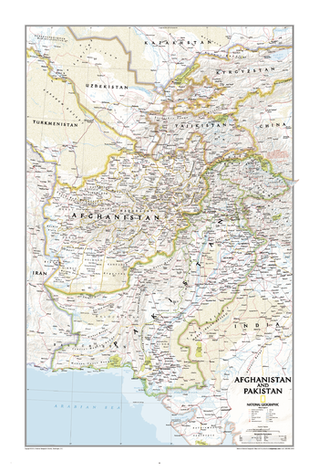
Afghanistan, Pakistan
National Geographic
This finely detailed political map shows up-to-date country boundaries and place names, as well as beautiful shaded relief. The map covers a broad geographic area ranging from northern Africa through the Middle East to the western edge of China and India. Includes complete coverage of Afghanistan, Pakistan, Tajikistan, Iran, Iraq, Kuwait, Syria, Israel, Jordan, Lebanon, Saudi Arabia, Qatar, Bahrain, United Arab Emirates, Yemen, Oman, Cyprus, and Eritrea. Also includes parts of India, China, Kyrgyzstan, Uzbekistan, Turkmenistan, Azerbaijan, Armenia, Turkey, Egypt, Sudan, Ethiopia, and Djibouti.
Page Size: 21.5 x 32.75 in (546 x 831 mm)
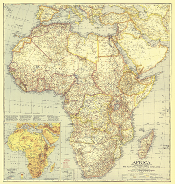
Africa - Published 1935
National Geographic
Africa underwent tremendous change in the early parts of the 20th Century. Access to air travel and increased motor vehicle availability led to increased travel led to increased development and modernization. This beautiful map, produced by the National Geographic cartographic section in June of 1935, tells the story of a continent amidst the old and new. Thorough research and spectacular detail are hallmarks of this beautiful map, one that should be part of any map collection.
Page Size: 29.5 x 31.25 in (747 x 788 mm)
Africa - Published 1943
National Geographic
The North African campaign was just drawing to a close when this map was published in February of 1943 to accompany an article entitled "Africa, First of 1943 Global Warfare Maps." A great addition to any World War II map collection, and a compelling companion to the earlier and later National Geographic maps of the "Dark Continent."
Page Size: 29.5 x 31.75 in (748 x 802 mm)
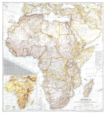
Africa - Published 1960
National Geographic
This map was created when many African nations were struggling and winning their independence from colonization. Features country boundaries as they existed on July 15, 1960. Published in September 1960 with three articles including "Africa: The Winds of Freedom Stir a Continent."
Page Size: 19 x 25 in (480 x 631 mm)
Africa - Published 1980
National Geographic
This classic Africa map is a perfect combination of exceptional cartography and rich detail. Published in February of 1980 as a companion to the map"Africa, Its Political Development."
Page Size: 23 x 29.25 in (578 x 741 mm)
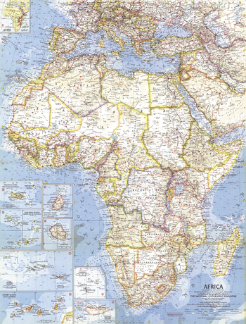
Africa - Published 1990
National Geographic
Discover the ever-changing continent of Africa with this vibrant, detailed map. Published in December of 1990 as a companion to the "Africa Threatened" map and three articles on Africa including "A Gathering of Waters and Wildlife."
Page Size: 22.25 x 28.75 in (560 x 726 mm)
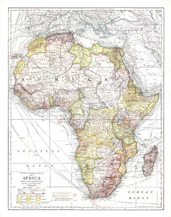
Africa - Published 1909
National Geographic
This historic map of Africa takes you back to 1909, a time when the "Dark Continent" was barely known in the outside world. A time when the only way to get to far off places like Abyssinia, the Congo State, and Bechuanaland Protectorate was to take a long sea voyage, then travel many miles by rail. National Geographic was among the first to bring this amazing land to the world, and this incredible map provides a time capsule into these times. Artistic cartography and painstaking detail make this a map for any collector.
Page Size: 17 x 21.5 in (431 x 544 mm)
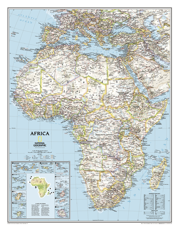
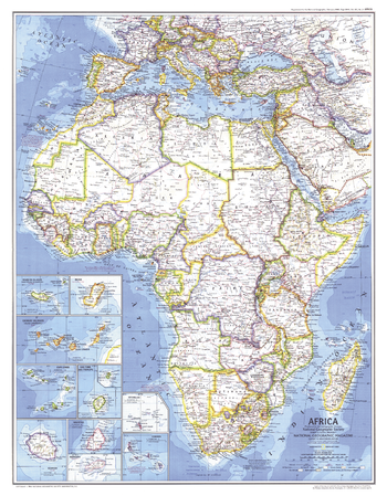
Africa Classic
National Geographic
Our classic political map of Africa features country boundaries, place names, bodies of water, airports, major highways and roads, and much more. Includes the most accurate and up to date boundaries and names for all countries including Algeria, Angola, Benin, Botswana, Burkina Faso, Burundi, Cameroon, Cape Verde, Central African Republic, Chad, Democratic Republic of the Congo, Republic of Congo, Côte d'Ivoire, Djibouti, Egypt, Equatorial Guinea, Eritrea, Ethiopia, Gabon, Gambia, Ghana, Guinea, Guinea-Bissau, Kenya, Liberia, Libya, Madagascar, Malawi, Mali, Mauritania, Morocco, Mozambique, Namibia, Niger, Nigeria, Rwanda, Senegal, Sierra Leone, Somalia, South Africa, Sudan, South Sudan, Tanzania, Togo, Tunisia, Uganda, Zambia, Zimbabwe and the island nations off the coast of Africa.
Page Size: 24 x 31 in (610 x 784 mm)
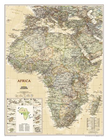
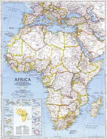
Africa Executive
National Geographic
Our executive-style political map of Africa features country boundaries, place names, bodies of water, airports, major highways and roads, and much more. Includes the most accurate and up to date boundaries and names for all countries including Algeria, Angola, Benin, Botswana, Burkina Faso, Burundi, Cameroon, Cape Verde, Central African Republic, Chad, Democratic Republic of the Congo, Republic of Congo, Côte d'Ivoire, Djibouti, Egypt, Equatorial Guinea, Eritrea, Ethiopia, Gabon, Gambia, Ghana, Guinea, Guinea-Bissau, Kenya, Liberia, Libya, Madagascar, Malawi, Mali, Mauritania, Morocco, Mozambique, Namibia, Niger, Nigeria, Rwanda, Senegal, Sierra Leone, Somalia, South Africa, Sudan, South Sudan, Tanzania, Togo, Tunisia, Uganda, Zambia, Zimbabwe and the island nations off the coast of Africa.
Page Size: 24 x 31 in (610 x 784 mm)
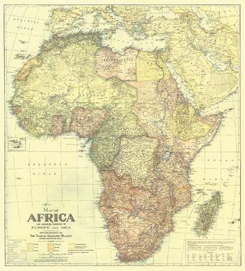
Africa Map with portions of Europe and Asia - Published 1922
National Geographic
In October 1922, National Geographic devoted an entire issue to the continent of Africa which included this beautifully crafted map. Discover Africa in the early 20th century when transportation on the continent was in its infancy and many rivers were yet unexplored.
Page Size: 28.5 x 31.5 in (721 x 798 mm)
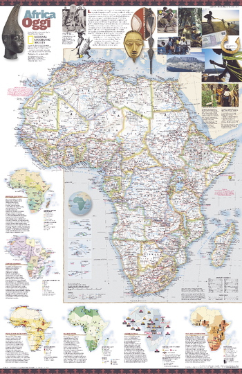
Africa Oggi - Published 2001
National Geographic
Published in September 2001, this attractive map of Africa translated into Italian contains a wealth of information about the enigmatic continent.
Page Size: 20.25 x 31.25 in (514 x 794 mm)
Africa Physical - Atlas of the World, 10th Edition
National Geographic
null
Page Size: 28 x 22 in (711 x 559 mm)

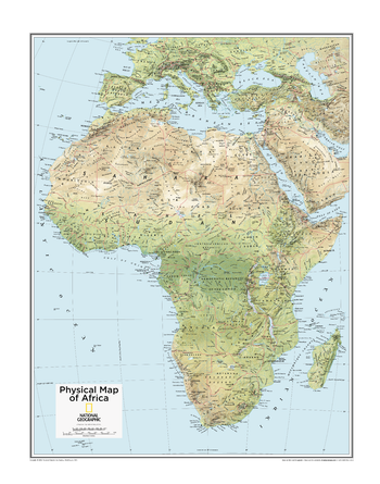
Africa Physical - Atlas of the World, 11th Edition
National Geographic
This map of physical features can fit in any space. Showcasing Africa in stunning detail with state-of-the-art cartographic techniques delivering accuracy and exceptional quality, the innovative and engaging design makes the content easily accessible and user-friendly.
Ideal for classrooms with an emphasis on teaching geography or environmental themes. The inclusion of physical features on this wall map gives your students a genuine feel for how our world appears.
This physical map of Africa uses a bright, easy to read color palette featuring blue oceans and stunning shaded relief that has been featured on National Geographic wall maps for over 75 years. Drawn in the Azimuthal Equidistant projection, this map ensures that all points on the map are at proportionally correct distances from the center point.
Names of geographic features such as international boundaries, cities, rivers and lakes are carefully placed on the map to maintain legibility.
This map is found in National Geographic's 11th Edition World Atlas and is now available as a stand alone product.
Page Size: 24 x 31.5 in (610 x 798 mm)
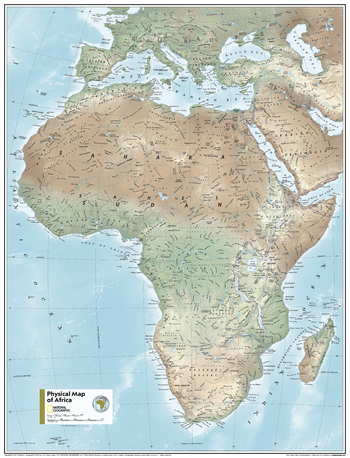
Africa Physical - Atlas of the World, 11th Edition - Compact
National Geographic
This map of physical features can fit in any space. Showcasing Africa in stunning detail with state-of-the-art cartographic techniques delivering accuracy and exceptional quality, the innovative and engaging design makes the content easily accessible and user-friendly.
Ideal for classrooms with an emphasis on teaching geography or environmental themes. The inclusion of physical features on this wall map gives your students a genuine feel for how our world appears.
This physical map of Africa uses a bright, easy to read color palette featuring blue oceans and stunning shaded relief that has been featured on National Geographic wall maps for over 75 years. Drawn in the Azimuthal Equidistant projection, this map ensures that all points on the map are at proportionally correct distances from the center point.
Names of geographic features such as international boundaries, cities, rivers and lakes are carefully placed on the map to maintain legibility.
This map is found in National Geographic's 11th Edition World Atlas and is now available as a stand alone product.
Page Size: 16.25 x 21.5 in (413 x 540 mm)
No search results