


MapSherpa Catalog
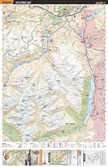
CCBC13 Tatlayoko Lake - Cariboo Chilcotin Coast BC Topo
Backroad Mapbooks
This recreation topographic map for the Tatlayoko Lake area highlights all the logging roads, trails and recreational Points of Interest including hunting, camping, hiking, mountain biking, canoeing, kayaking, backcountry skiing, wildlife viewing, ATVing, snowmobiling and more. No other map provides you with this level of recreational and topographic detail for the Homathko River area. Covering the Tatlayoko Lake, Sapeye Lake, Horn Lake, Bluff Lake, Middle Lake, Miner Lake, Homathko River Tatlayoko Protected Area, Dumbell Lake, Eagle Lake, Tatla Lake and more, this map contains new features such as private land and labelled fish species. The 1:85,000 scale map covers 3,040 km2 (1,175 mi2), measuring 50 x 63.5 km (30 x 39.5 mi).
Page Size: 24 x 37 in (610 x 940 mm)
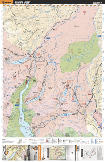
CCBC14 Nemaiah Valley - Cariboo Chilcotin Coast BC Topo
Backroad Mapbooks
This recreation topographic map for the Nemaiah Valley area highlights all the logging roads, trails and recreational Points of Interest including hunting, camping, hiking, mountain biking, canoeing, kayaking, backcountry skiing, wildlife viewing, ATVing, snowmobiling and more. No other map provides you with this level of recreational and topographic detail for the Homathko River area. Covering the Chilko Lake, Ts'yl-Os Prov Park, Nuntsi Prov Park, Choelquoit Lake, Chilko River, Chaunigan Lake, Taseko River, Tsuniah Lake, Konni Lake, Nemaiah Valley and more, this map contains new features such as private land and labelled fish species. The 1:85,000 scale map covers 3,040 km2 (1,175 mi2), measuring 50 x 63.5 km (30 x 39.5 mi).
Page Size: 24 x 37 in (610 x 940 mm)

CCBC15 Big Creek Prov Park - Cariboo Chilcotin Coast BC Topo
Backroad Mapbooks
This recreation topographic map for the Big Creek Prov Park area highlights all the logging roads, trails and recreational Points of Interest including hunting, camping, hiking, mountain biking, canoeing, kayaking, backcountry skiing, wildlife viewing, ATVing, snowmobiling and more. No other map provides you with this level of recreational and topographic detail for the Homathko River area. Covering the Big Creek, Fish Lake, Fletcher Lake, Scum Lake, Chilcotin River, Hanceville, Big Creek Provincial Park and more, this map contains new features such as private land and labelled fish species. The 1:85,000 scale map covers 3,040 km2 (1,175 mi2), measuring 50 x 63.5 km (30 x 39.5 mi).
Page Size: 24 x 37 in (610 x 940 mm)
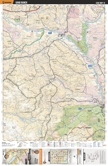
CCBC16 Gang Ranch - Cariboo Chilcotin Coast BC Topo
Backroad Mapbooks
This recreation topographic map for the Gang Ranch area highlights all the logging roads, trails and recreational Points of Interest including hunting, camping, hiking, mountain biking, canoeing, kayaking, backcountry skiing, wildlife viewing, ATVing, snowmobiling and more. No other map provides you with this level of recreational and topographic detail for the Homathko River area. Covering the Churn Creek Protected Area, Gaspard Creek, Junction Sheep Range Prov Park, Fraser River, Gang Ranch, Chilcotin River, Big Creek, Becher House, Alkali Lake, Gaspard Lake and more, this map contains new features such as private land and labelled fish species. The 1:85,000 scale map covers 3,040 km2 (1,175 mi2), measuring 50 x 63.5 km (30 x 39.5 mi).
Page Size: 24 x 37 in (610 x 940 mm)
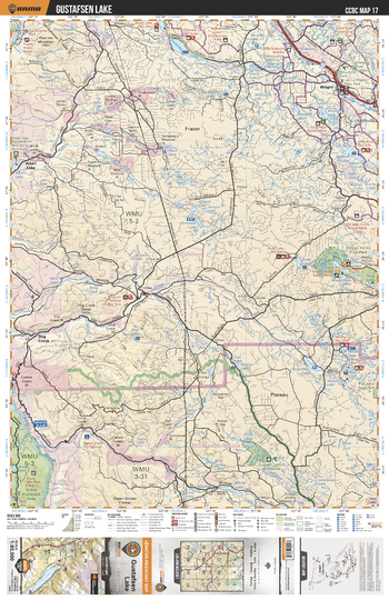
CCBC17 Gustafsen Lake - Cariboo Chilcotin Coast BC Topo
Backroad Mapbooks
This recreation topographic map for the Gustafsen Lake area highlights all the logging roads, trails and recreational Points of Interest including hunting, camping, hiking, mountain biking, canoeing, kayaking, backcountry skiing, wildlife viewing, ATVing, snowmobiling and more. No other map provides you with this level of recreational and topographic detail for the Homathko River area. Covering the Churn Creek Protected Area, Moose Valley Prov Park, Whale Lake, Boar Lake, Helena Lake, Wright, Spring House, Alkali Lake, Chimney Lake, Fraser River and more, this map contains new features such as private land and labelled fish species. The 1:85,000 scale map covers 3,040 km2 (1,175 mi2), measuring 50 x 63.5 km (30 x 39.5 mi).
Page Size: 24 x 37 in (610 x 940 mm)
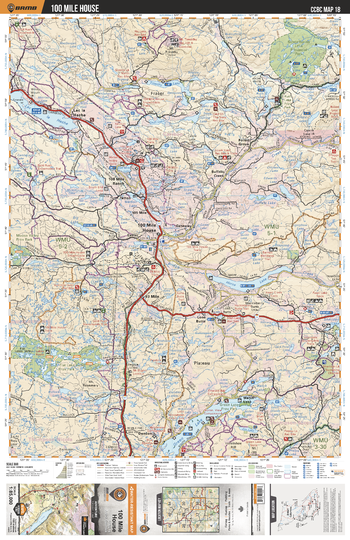
CCBC18 100 Mile House - Cariboo Chilcotin Coast BC Topo
Backroad Mapbooks
This recreation topographic map for the 100 Mile House area highlights all the logging roads, trails and recreational Points of Interest including hunting, camping, hiking, mountain biking, canoeing, kayaking, backcountry skiing, wildlife viewing, ATVing, snowmobiling and more. No other map provides you with this level of recreational and topographic detail for the Homathko River area. Covering the 100 Mile House, Green Lake, Flat Lake Prov Park, Watch Lake, Horse Lake, 108 Mile Ranch, Lac La Hache, Ruth Lake, Schoolhouse Lake Prov Park, Lone Butte and more, this map contains new features such as private land and labelled fish species. The 1:85,000 scale map covers 3,040 km2 (1,175 mi2), measuring 50 x 63.5 km (30 x 39.5 mi).
Page Size: 24 x 37 in (610 x 940 mm)
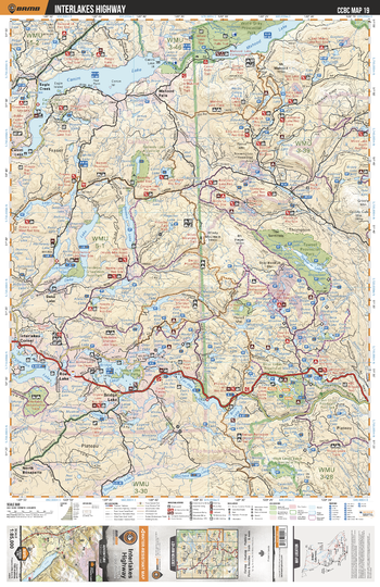
CCBC19 Interlakes Highway - Cariboo Chilcotin Coast BC Topo
Backroad Mapbooks
This recreation topographic map for the Interlakes Highway area highlights all the logging roads, trails and recreational Points of Interest including hunting, camping, hiking, mountain biking, canoeing, kayaking, backcountry skiing, wildlife viewing, ATVing, snowmobiling and more. No other map provides you with this level of recreational and topographic detail for the Homathko River area. Covering the Canim Lake, Mahood Lake, Wells Gray Prov Park, Taweel Prov Park, Emar Lakes Prov Park, Bridge Lake, Sheridan Lake, Deka Lake, High Lakes Basin Prov Park, Emar Lakes Prov Park and more, this map contains new features such as private land and labelled fish species. The 1:85,000 scale map covers 3,040 km2 (1,175 mi2), measuring 50 x 63.5 km (30 x 39.5 mi).
Page Size: 24 x 37 in (610 x 940 mm)
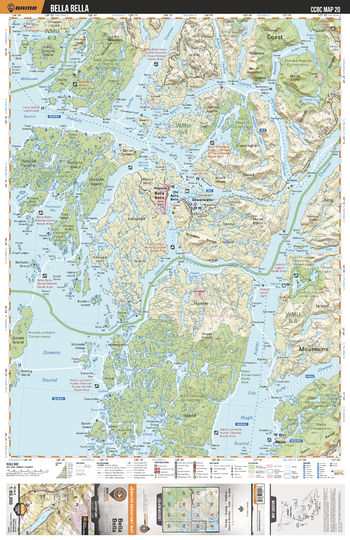
CCBC20 Bella Bella - Cariboo Chilcotin Coast BC Topo
Backroad Mapbooks
This recreation topographic map for the Bella Bella area highlights all the logging roads, trails and recreational Points of Interest including hunting, camping, hiking, mountain biking, canoeing, kayaking, backcountry skiing, wildlife viewing, ATVing, snowmobiling and more. No other map provides you with this level of recreational and topographic detail for the Homathko River area. Covering the Outer Central Coast Islands Conservancy, Hakai/Luxvbalis Conservancy, Lady Douglas-Don Penninsula Conservancy,Spiller Channel, Seaforth Channe, Fisher Channel, Old Bella Bella, Campbell Island, Shearwater, Namu, Bella Bella and more, this map contains new features such as private land and labelled fish species. The 1:85,000 scale map covers 3,040 km2 (1,175 mi2), measuring 50 x 63.5 km (30 x 39.5 mi).
Page Size: 24 x 37 in (610 x 940 mm)
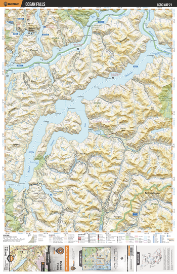
CCBC21 Ocean Falls - Cariboo Chilcotin Coast BC Topo
Backroad Mapbooks
This recreation topographic map for the Ocean Falls area highlights all the logging roads, trails and recreational Points of Interest including hunting, camping, hiking, mountain biking, canoeing, kayaking, backcountry skiing, wildlife viewing, ATVing, snowmobiling and more. No other map provides you with this level of recreational and topographic detail for the Homathko River area. Covering the Nooseseck Conservancy, Restoration Bay Conservancy, Clyak Estuary Conservancy, Cascade-Sutslem Conservancy, Hot Springs-No Name Creek Conservancy, Burke Channel, Labouchere Channel, Dean Channel, Ocean Falls and more, this map contains new features such as private land and labelled fish species. The 1:85,000 scale map covers 3,040 km2 (1,175 mi2), measuring 50 x 63.5 km (30 x 39.5 mi).
Page Size: 24 x 37 in (610 x 940 mm)
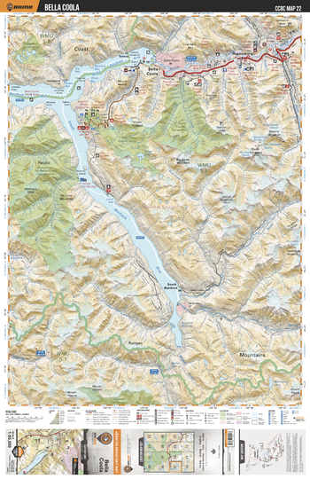
CCBC22 Bella Coola - Cariboo Chilcotin Coast BC Topo
Backroad Mapbooks
This recreation topographic map for the Bella Coola area highlights all the logging roads, trails and recreational Points of Interest including hunting, camping, hiking, mountain biking, canoeing, kayaking, backcountry skiing, wildlife viewing, ATVing, snowmobiling and more. No other map provides you with this level of recreational and topographic detail for the Homathko River area. Covering the South Bentinck Arm, South Bentinck, Thorsen Creek Conservancy, Bella Coola, Hagensborg, Hotsprings No Name Creek Conservancy, Taleomey River, Sallomt Peak, Snooka Creek and more, this map contains new features such as private land and labelled fish species. The 1:85,000 scale map covers 3,040 km2 (1,175 mi2), measuring 50 x 63.5 km (30 x 39.5 mi).
Page Size: 24 x 37 in (610 x 940 mm)
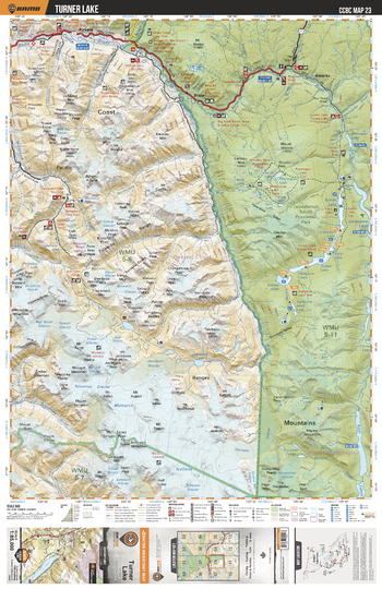
CCBC23 Turner Lake - Cariboo Chilcotin Coast BC Topo
Backroad Mapbooks
This recreation topographic map for the Turner Lake area highlights all the logging roads, trails and recreational Points of Interest including hunting, camping, hiking, mountain biking, canoeing, kayaking, backcountry skiing, wildlife viewing, ATVing, snowmobiling and more. No other map provides you with this level of recreational and topographic detail for the Homathko River area. Covering the Tweedsmuir Provincial Park, Monarch Icefield, Talchako River, Turner Lake, Lonesome Lake, Atnarko River, Stuie, Firvale and more, this map contains new features such as private land and labelled fish species. The 1:85,000 scale map covers 3,040 km2 (1,175 mi2), measuring 50 x 63.5 km (30 x 39.5 mi).
Page Size: 24 x 37 in (610 x 940 mm)
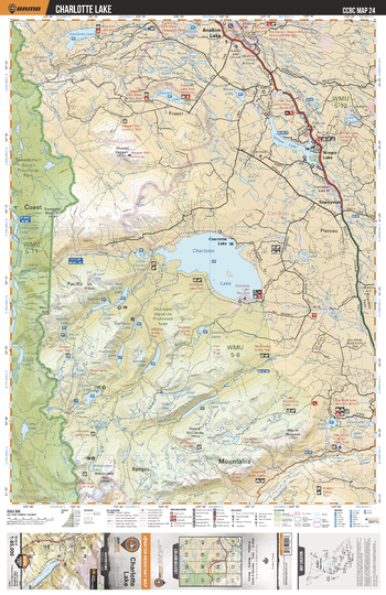
CCBC24 Charlotte Lake - Cariboo Chilcotin Coast BC Topo
Backroad Mapbooks
This recreation topographic map for the Charlotte Lake area highlights all the logging roads, trails and recreational Points of Interest including hunting, camping, hiking, mountain biking, canoeing, kayaking, backcountry skiing, wildlife viewing, ATVing, snowmobiling and more. No other map provides you with this level of recreational and topographic detail for the Homathko River area. Covering the Charlotte Lake, Charlotte Alplands Protected Area, Nimpo Lake, Kappan Lake, Hotnarko Lake, Tweedsmuir Prov Park, Dean River, Anahim Lake, Big Stick Lake, Towdystan and more, this map contains new features such as private land and labelled fish species. The 1:85,000 scale map covers 3,040 km2 (1,175 mi2), measuring 50 x 63.5 km (30 x 39.5 mi).
Page Size: 24 x 37 in (610 x 940 mm)
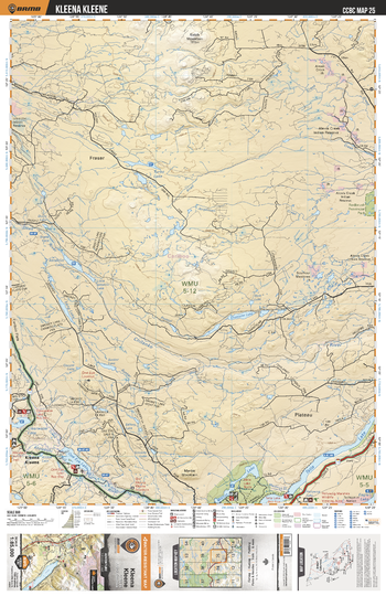
CCBC25 Kleena Kleene - Cariboo Chilcotin Coast BC Topo
Backroad Mapbooks
This recreation topographic map for the Kleena Kleene area highlights all the logging roads, trails and recreational Points of Interest including hunting, camping, hiking, mountain biking, canoeing, kayaking, backcountry skiing, wildlife viewing, ATVing, snowmobiling and more. No other map provides you with this level of recreational and topographic detail for the Homathko River area. Covering the Kleena Kleane, Tatla Lake, One Eye Lake, Klinaklini River, Chilanko River, Turbo Lake, Aktaklin Lake, Martin Lake, Clearwater Lake, Satah Mtn and more, this map contains new features such as private land and labelled fish species. The 1:85,000 scale map covers 3,040 km2 (1,175 mi2), measuring 50 x 63.5 km (30 x 39.5 mi).
Page Size: 24 x 37 in (610 x 940 mm)
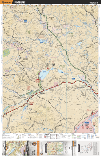
CCBC26 Puntzi Lake - Cariboo Chilcotin Coast BC Topo
Backroad Mapbooks
This recreation topographic map for the Puntzi Lake area highlights all the logging roads, trails and recreational Points of Interest including hunting, camping, hiking, mountain biking, canoeing, kayaking, backcountry skiing, wildlife viewing, ATVing, snowmobiling and more. No other map provides you with this level of recreational and topographic detail for the Homathko River area. Covering the Puntzi Lake, Chilanko Forks, Chilanko River, Chilcotin Lake, Salt Lake, Punti Lake, Chezacut, Redstone, Pyper Lake and more, this map contains new features such as private land and labelled fish species. The 1:85,000 scale map covers 3,040 km2 (1,175 mi2), measuring 50 x 63.5 km (30 x 39.5 mi).
Page Size: 24 x 37 in (610 x 940 mm)
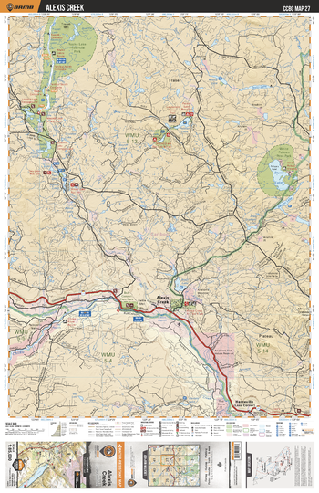
CCBC27 Alexis Creek - Cariboo Chilcotin Coast BC Topo
Backroad Mapbooks
This recreation topographic map for the Alexis Creek area highlights all the logging roads, trails and recreational Points of Interest including hunting, camping, hiking, mountain biking, canoeing, kayaking, backcountry skiing, wildlife viewing, ATVing, snowmobiling and more. No other map provides you with this level of recreational and topographic detail for the Homathko River area. Covering the Alexis Creek, Chilko River, Nazko Lake Prov Park, White Pelican Prov Park, Stum Lake, Hanceville, Bull Canyon, Alexis Lake, Palmer Lake, Tautri Lake and more, this map contains new features such as private land and labelled fish species. The 1:85,000 scale map covers 3,040 km2 (1,175 mi2), measuring 50 x 63.5 km (30 x 39.5 mi).
Page Size: 24 x 37 in (610 x 940 mm)
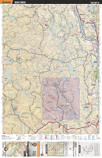
CCBC28 Riske Creek - Cariboo Chilcotin Coast BC Topo
Backroad Mapbooks
This recreation topographic map for the Riske Creek area highlights all the logging roads, trails and recreational Points of Interest including hunting, camping, hiking, mountain biking, canoeing, kayaking, backcountry skiing, wildlife viewing, ATVing, snowmobiling and more. No other map provides you with this level of recreational and topographic detail for the Homathko River area. Covering the Riske Creek, McLease Lake, Soda Creek, Twan Lake, Gibraltar, Macalister, Meldrum Creek, Chilcotin Forest, The Dome, McIntyre Lake and more, this map contains new features such as private land and labelled fish species. The 1:85,000 scale map covers 3,040 km2 (1,175 mi2), measuring 50 x 63.5 km (30 x 39.5 mi).
Page Size: 24 x 37 in (610 x 940 mm)
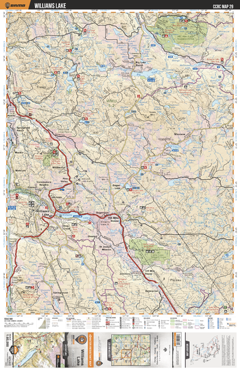
CCBC29 Williams Lake - Cariboo Chilcotin Coast BC Topo
Backroad Mapbooks
This recreation topographic map for the Williams Lake area highlights all the logging roads, trails and recreational Points of Interest including hunting, camping, hiking, mountain biking, canoeing, kayaking, backcountry skiing, wildlife viewing, ATVing, snowmobiling and more. No other map provides you with this level of recreational and topographic detail for the Homathko River area. Covering the Williams Lake, UBC Alex Fraser Research Forest, Big Lake, Tyee Lake, Wildwood, Meldrum, Blue Lake, Springhouse, Miocene, Forest Lake and more, this map contains new features such as private land and labelled fish species. The 1:85,000 scale map covers 3,040 km2 (1,175 mi2), measuring 50 x 63.5 km (30 x 39.5 mi).
Page Size: 24 x 37 in (610 x 940 mm)
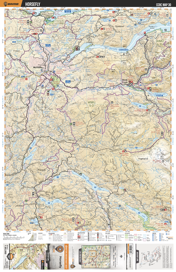
CCBC30 Horsefly - Cariboo Chilcotin Coast BC Topo
Backroad Mapbooks
This recreation topographic map for the Horsefly area highlights all the logging roads, trails and recreational Points of Interest including hunting, camping, hiking, mountain biking, canoeing, kayaking, backcountry skiing, wildlife viewing, ATVing, snowmobiling and more. No other map provides you with this level of recreational and topographic detail for the Homathko River area. Covering the Horsefly, Black Creek, Horsefly Lake, Quesnel Lake, Eagle (Murphy) Lake, McIntosh Lakes, Spout Lake, Tisdall Lake, McKinley Lake, Big Timothy Mtn and more, this map contains new features such as private land and labelled fish species. The 1:85,000 scale map covers 3,040 km2 (1,175 mi2), measuring 50 x 63.5 km (30 x 39.5 mi).
Page Size: 24 x 37 in (610 x 940 mm)
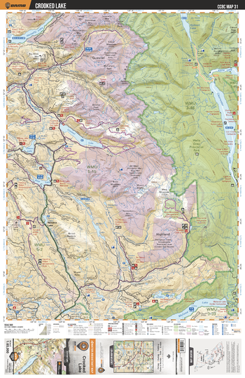
CCBC31 Crooked Lake - Cariboo Chilcotin Coast BC Topo
Backroad Mapbooks
This recreation topographic map for the Clearwater Lake area highlights all the logging roads, trails and recreational Points of Interest including hunting, camping, hiking, mountain biking, canoeing, kayaking, backcountry skiing, wildlife viewing, ATVing, snowmobiling and more. No other map provides you with this level of recreational and topographic detail for the Homathko River area. Covering the Wells Gray Prov Park, Clearwater Lake, Azure Lake, Crooked Lake, Bosk Lake, Mahood Lake, Elbow Lake, Hobson Lake, Horsefly Lake, Pendleton Lakes and more, this map contains new features such as private land and labelled fish species. The 1:85,000 scale map covers 3,040 km2 (1,175 mi2), measuring 50 x 63.5 km (30 x 39.5 mi).
Page Size: 24 x 37 in (610 x 940 mm)
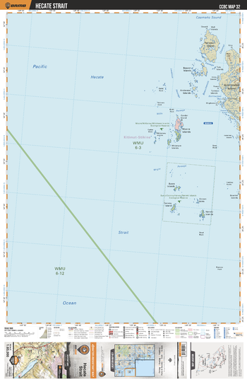
CCBC32 Hecate Strait - Cariboo Chilcotin Coast BC Topo
Backroad Mapbooks
This recreation topographic map for the Hecate Strait area highlights all the logging roads, trails and recreational Points of Interest including hunting, camping, hiking, mountain biking, canoeing, kayaking, backcountry skiing, wildlife viewing, ATVing, snowmobiling and more. No other map provides you with this level of recreational and topographic detail for the Homathko River area. Covering the Hecate Strait, Moore/Mckenny/Whitmore Islands Ecological Reserve, Byers/Conroy/Harvey/Sinnett Islands Ecological Reserve and more, this map contains new features such as private land and labelled fish species. The 1:85,000 scale map covers 3,040 km2 (1,175 mi2), measuring 50 x 63.5 km (30 x 39.5 mi).
Page Size: 24 x 37 in (610 x 940 mm)
No search results