


MapSherpa Catalog
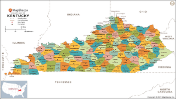
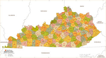
Kentucky Counties Map - Large
MapSherpa
This map has been created exclusively for MapSherpa, and designed for reference or business use. Clear and clean colors & fonts matched with cartographic research makes this map of Kentucky Counties Map easily readable and useful. The map shows the 120 counties of Kentucky and their borders across the Bluegrass State.
Page Size: 48 x 27 in (1219 x 686 mm)
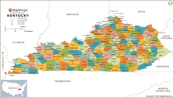
Kentucky Counties Map - Standard
MapSherpa
This map has been created exclusively for MapSherpa, and designed for reference or business use. Clear and clean colors & fonts matched with cartographic research makes this map of Kentucky Counties Map easily readable and useful. The map shows the 120 counties of Kentucky and their borders across the Bluegrass State.
Page Size: 36 x 20.25 in (914 x 514 mm)
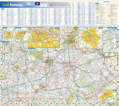
Kentucky State Wall Map
Globe Turner
This colorful, easy-to-read state map of Kentucky identifies all major thoroughfares, secondary roads, freeway interchanges, rest areas, distance markers, landmarks, recreational areas, and more. Shaded relief on the state map provides a three-dimensional sense of Kentucky's topography. Detailed city inset maps of Bowling Green, Frankfort, Lexington, Louisville, and Owensboro are based on the latest street information from our cartographic experts. Up-to-date insets of Mammoth Cave National Park and Land Between the Lakes National Recreation Area provide must-see information on these tourist areas. County and city indices make it simple to locate even the smallest town.
Page Size: 20.75 x 18.5 in (524 x 467 mm)
Kentucky ZIP Code Map
MapSherpa
This map of Kentucky shows ZIP codes overlaid on a road map. Base map features include municipality and county boundaries, major road network features, and state and national parks and conservation areas.
Page Size: 48 x 36 in (1219 x 914 mm)

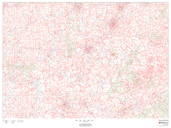
Kentucky ZIP Code Map with Counties - Extra Large
MapSherpa
This map has been created exclusively for MapSherpa, and designed for business or reference use. Clear and clean colors & fonts matched with cartographic research makes this Kentucky Zip Code Map with Counties easily readable and useful. The map shows the 120 counties of Kentucky and the borders of the 761 zip codes across the Bluegrass State.
Page Size: 60 x 33 in (1524 x 837 mm)
Kentucky ZIP Code Map with Counties - Large
MapSherpa
This map has been created exclusively for MapSherpa, and designed for business or reference use. Clear and clean colors & fonts matched with cartographic research makes this Kentucky Zip Code Map with Counties easily readable and useful. The map shows the 120 counties of Kentucky and the borders of the 761 zip codes across the Bluegrass State.
Page Size: 48 x 26.5 in (1219 x 670 mm)

Kentucky ZIP Code Map with Counties - Standard
MapSherpa
This map has been created exclusively for MapSherpa, and designed for business or reference use. Clear and clean colors & fonts matched with cartographic research makes this Kentucky Zip Code Map with Counties easily readable and useful. The map shows the 120 counties of Kentucky and the borders of the 761 zip codes across the Bluegrass State.
Page Size: 36 x 20 in (914 x 502 mm)
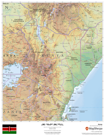
Kenya
MapSherpa
This beautiful map shows physical and political features for Kenya and surrounding areas. Relief shading and the use of different colours by height above sea level are both informative and attractive.
Page Size: 17 x 22 in (432 x 559 mm)
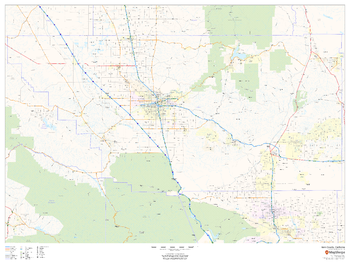
Kern County, California
MapSherpa
This map of Kern County, California shows regional level information. Base map features include highways and major roads with labelling; high level land use such as parks and recreation areas; and a selection of points of interest including transportation hubs like airports and train stations, tourist information and police stations.
Page Size: 48 x 36 in (1219 x 914 mm)
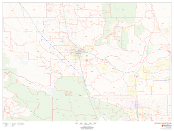
Kern County, California ZIP Codes
MapSherpa
This map of Kern County, California shows ZIP code areas overlaid on a road map. Ideal for planning of deliveries, home ervices, sales territories, real estate and much more. Base map features include all roads with major roads and highways labelled; neighborhood names; railways; and high level land use such as parks and recreation areas, industrial areas and hospital campuses.
Page Size: 48 x 36 in (1219 x 914 mm)
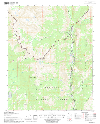
Kern Lake Quadrangle, California
United States Department of Agriculture Forest Service
United States Department of Agriculture Forestry Service topographical map of Kern Lake, Sequoia National Forest, California.
Page Size: 21.75 x 27 in (552 x 686 mm)
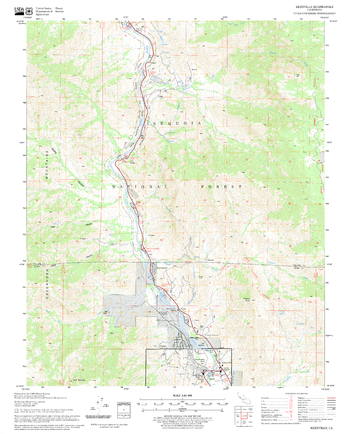
Kernville Quadrangle, California
United States Department of Agriculture Forest Service
United States Department of Agriculture Forestry Service topographical map of Kernville, Sequoia National Forest, California.
Page Size: 21.75 x 27 in (552 x 686 mm)
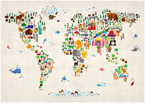
Kids Animal Map of the World
Maps International
Colourful and vibrant map of the world made from animals. Look closely and you will see the animals are shown in their home continents. Can you spot the African Lion or the Chinese Panda? This Children's Animal Map of the World will look great on your child's bedroom or nursery wall and is a fun way to help younger children learn about the world.
Page Size: 33.25 x 23.5 in (841 x 594 mm)
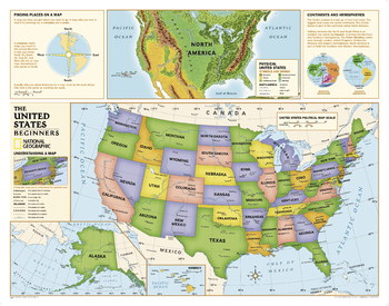
Kids Beginners USA Education: Grades K-3
National Geographic
Beginners USA Education map of the United States for grades K-3. National Geographic's graded-series of maps are the first to address the unique needs of K-12 students as they advance their understanding of our World.<br>Unlike other classroom poster maps, the world maps use the Winkel-Triple projection, which provides the best combination of size, shape, and distance giving the student the best visual representation of the Earth's surface in two dimensions. This solves the effect seen on other maps where Greenland appears larger than South America.<br><br>Our Beginner Series, grades K-3, contains an easy to read maps of the World and United States.
Page Size: 51.75 x 40.75 in (1310 x 1031 mm)
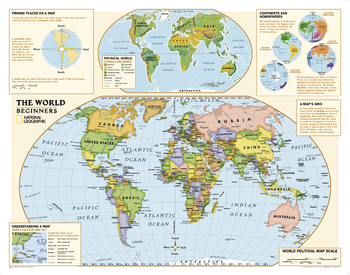
Kids Beginners World Education: Grades K-3
National Geographic
Beginners USA Education map of the world for grades K-3. National Geographic's graded-series of maps are the first to address the unique needs of K-12 students as they advance their understanding of our World.<br>Unlike other classroom poster maps, the world maps use the Winkel-Triple projection, which provides the best combination of size, shape, and distance giving the student the best visual representation of the Earth's surface in two dimensions. This solves the effect seen on other maps where Greenland appears larger than South America.<br><br>Our Beginner Series, grades K-3, contains an easy to read maps of the World and United States.
Page Size: 51.75 x 40.75 in (1310 x 1031 mm)
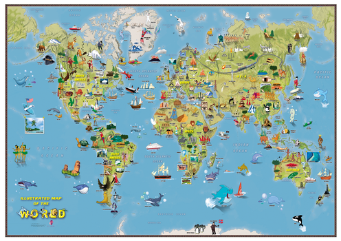
Kids Cartoon Map of the World
Maps International
This is a fantastic fun Children's Illustrated Map of the World perfect for Children aged 5 upwards. The detailed illustrations show people and local culture, animals and marine life, famous natural features and manmade landmarks plus a range of other fun illustrations. Find the Polar Bears playing catch or the Aborigines dancing to the didgeridoo, plus learn where the Victoria Falls or Mount Everest are in the world. The World Map itself show the Continents, Sea and Ocean names and also shows hill and sea shading.
Page Size: 33.25 x 23.5 in (841 x 594 mm)
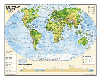
Kids Physical World Education: Grades 4-12
National Geographic
Physical map of the world for grades 4-12. National Geographic's graded-series of maps are the first to address the unique needs of K-12 students as they advance their understanding of our World.<br>Unlike other classroom poster maps, the world maps use the Winkel-Triple projection, which provides the best combination of size, shape, and distance giving the student the best visual representation of the Earth's surface in two dimensions. This solves the effect seen on other maps where Greenland appears larger than South America.<br><br>Our Physical Series, grades 6-12, helps advancing students understand the World's diverse landforms, Oceans, and terrain.
Page Size: 51.25 x 40.25 in (1298 x 1018 mm)
Kids Political USA Education: Grades 4-12
National Geographic
Political map of the United States for grades 4-12. National Geographic's graded-series of maps are the first to address the unique needs of K-12 students as they advance their understanding of our World.<br>Unlike other classroom poster maps, the world maps use the Winkel-Triple projection, which provides the best combination of size, shape, and distance giving the student the best visual representation of the Earth's surface in two dimensions. This solves the effect seen on other maps where Greenland appears larger than South America.<br><br>Our Political Series, grades 4-12, has up-to-date World and U.S. maps, increasing the detail of information for the teacher and student to utilize.
Page Size: 51.75 x 40.75 in (1310 x 1031 mm)
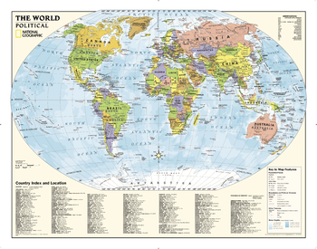
Kids Political World Education: Grades 4-12
National Geographic
Political map of the world for grades 4-12. National Geographic's graded-series of maps are the first to address the unique needs of K-12 students as they advance their understanding of our World.<br>Unlike other classroom poster maps, the world maps use the Winkel-Triple projection, which provides the best combination of size, shape, and distance giving the student the best visual representation of the Earth's surface in two dimensions. This solves the effect seen on other maps where Greenland appears larger than South America.<br><br>Our Political Series, grades 4-12, has up-to-date World and U.S. maps, increasing the detail of information for the teacher and student to utilize.
Page Size: 51.75 x 40.75 in (1310 x 1031 mm)
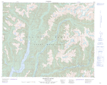
Kilbella River - 92 M/14 - British Columbia
Natural Resources Canada
Canadian topographic map of Kilbella River, British Columbia. NTS sheet 092M14 Edition 2.
Page Size: 31.75 x 25.25 in (803 x 638 mm)
No search results