


MapSherpa Catalog
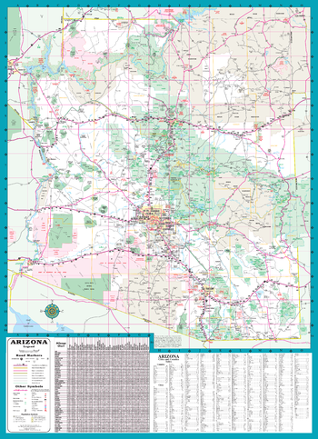
Arizona State Road Map
GM Johnson
A Five Star Road Map of Arizona. Also Includes: Complete Index & Mileage Chart
Page Size: 19.75 x 27.25 in (502 x 692 mm)
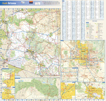
Arizona State Wall Map
Globe Turner
This colorful, easy-to-read state map of Arizona identifies all major thoroughfares, secondary roads, freeway interchanges, rest areas, distance markers, landmarks, recreational areas, and more. Shaded relief on the state map provides a three-dimensional sense of Arizona’s topography. Detailed inset maps of Bullhead City, Flagstaff, Phoenix, Tucson, and Yuma are based on the latest street information from our cartographic experts. An up-to-date inset of Grand Canyon National Park provides must-see information on this popular tourist destination. County and city indices make it simple to locate even the smallest town. City type sizes reflect the 2020 U.S. Census.
Page Size: 23.75 x 22.5 in (603 x 572 mm)
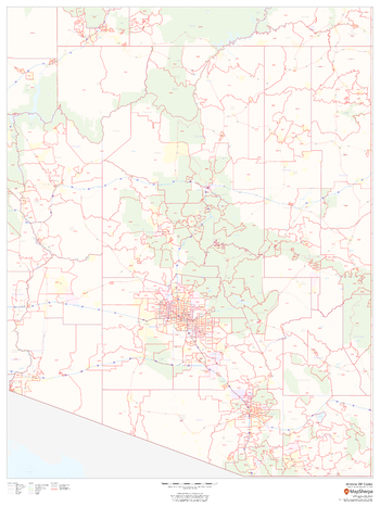
Arizona ZIP Code Map
MapSherpa
This map of Arizona shows ZIP codes overlaid on a road map. Base map features include municipality and county boundaries, major road network features, and state and national parks and conservation areas.
Page Size: 36 x 48 in (914 x 1219 mm)

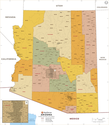
Arizona ZIP Code Map with Counties - Extra Large
MapSherpa
This map has been created exclusively for MapSherpa, and designed for business or reference use. Clear and clean colors & fonts matched with cartographic research makes this Arizona Zip Code Map with Counties easily readable and useful. The map shows the 15 counties of Arizona and the borders of the over 500 zip codes across the Grand Canyon State.
Page Size: 60 x 68.75 in (1524 x 1744 mm)

Arizona ZIP Code Map with Counties - Large
MapSherpa
This map has been created exclusively for MapSherpa, and designed for business or reference use. Clear and clean colors & fonts matched with cartographic research makes this Arizona Zip Code Map with Counties easily readable and useful. The map shows the 15 counties of Arizona and the borders of the over 500 zip codes across the Grand Canyon State.
Page Size: 48 x 55 in (1219 x 1396 mm)
Arizona ZIP Code Map with Counties - Standard
MapSherpa
This map has been created exclusively for MapSherpa, and designed for business or reference use. Clear and clean colors & fonts matched with cartographic research makes this Arizona Zip Code Map with Counties easily readable and useful. The map shows the 15 counties of Arizona and the borders of the over 500 zip codes across the Grand Canyon State.
Page Size: 36 x 41.25 in (914 x 1047 mm)

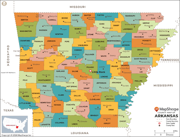
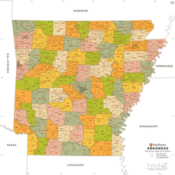
Arkansas Counties Map - Extra Large
MapSherpa
This map has been created exclusively for MapSherpa, and designed for reference or business use. Clear and clean colors & fonts matched with cartographic research makes this map of the 75 Arkansas counties easily readable and useful.
Page Size: 60 x 45.75 in (1524 x 1161 mm)
Arkansas Counties Map - Large
MapSherpa
This map has been created exclusively for MapSherpa, and designed for reference or business use. Clear and clean colors & fonts matched with cartographic research makes this map of the 75 Arkansas counties easily readable and useful.
Page Size: 48 x 36.75 in (1219 x 929 mm)

Arkansas Counties Map - Standard
MapSherpa
This map has been created exclusively for MapSherpa, and designed for reference or business use. Clear and clean colors & fonts matched with cartographic research makes this map of the 75 Arkansas counties easily readable and useful.
Page Size: 36 x 27.5 in (914 x 697 mm)
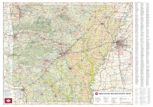
Arkansas Recreation Wall Map – 26 inch
Benchmark Maps
From the Ozark & Ouachita Mountains to the densely forested Timberlands and the Delta Lowlands, Arkansas contains a wealth of terrain, wildlife, and recreation possibilities. This wall map illustrates The Natural State’s diverse landscapes, country roads, and public land access.
Page Size: 37.25 x 26 in (943 x 660 mm)
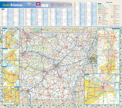
Arkansas State Wall Map
Globe Turner
This colorful, easy-to-read state map of Arkansas identifies all major thoroughfares, secondary roads, freeway interchanges, rest areas, distance markers, landmarks, recreational areas, and more. Shaded relief on the state map provides a three-dimensional sense of Arkansas’ topography. Detailed inset maps of Fayetteville/Bentonville, Fort Smith, Hot Springs, Little Rock, Pine Bluff, and Texarkana are based on the latest street information from our cartographic experts. County and city indices make it simple to locate even the smallest town.
Page Size: 20.75 x 18.5 in (524 x 467 mm)
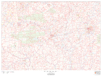
Arkansas ZIP Code Map
MapSherpa
This map of Arkansas shows ZIP codes overlaid on a road map. Base map features include municipality and county boundaries, major road network features, and state and national parks and conservation areas.
Page Size: 48 x 36 in (1219 x 914 mm)

Arkansas ZIP Code Map with Counties - Extra Large
MapSherpa
This map has been created exclusively for MapSherpa, and designed for business or reference use. Clear and clean colors & fonts matched with cartographic research makes this map of Arkansas' counties and ZIP codes easily readable and useful.
Page Size: 60 x 60 in (1524 x 1524 mm)

Arkansas ZIP Code Map with Counties - Large
MapSherpa
This map has been created exclusively for MapSherpa, and designed for business or reference use. Clear and clean colors & fonts matched with cartographic research makes this map of Arkansas' counties and ZIP codes easily readable and useful.
Page Size: 48 x 48 in (1219 x 1219 mm)
Arkansas ZIP Code Map with Counties - Standard
MapSherpa
This map has been created exclusively for MapSherpa, and designed for business or reference use. Clear and clean colors & fonts matched with cartographic research makes this map of Arkansas' counties and ZIP codes easily readable and useful.
Page Size: 36 x 36 in (914 x 914 mm)
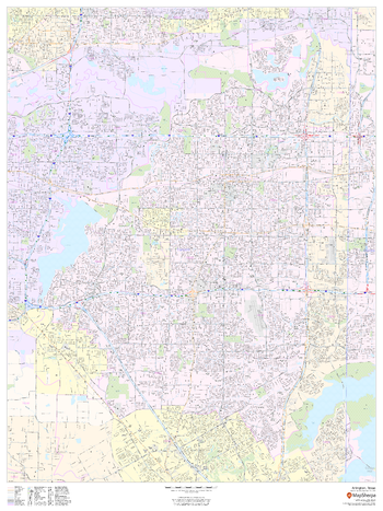
Arlington, Texas - Portrait
MapSherpa
This portrait-oriented map of Arlington, Texas shows detailed street level information including extensive street labeling. Ideal for planning of deliveries, home services, sales territories, real estate and much more. Base map features include all roads with major roads and highways labelled; neighborhood names; railways; high level land use such as parks and recreation areas, industrial areas and hospital campuses; and a variety of points of interest including schools, libraries, stadiums, museums, border crossings and more.
Page Size: 36 x 48 in (914 x 1219 mm)
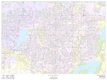
Arlington, Texas Inner Metro - Landscape
MapSherpa
This landscape-oriented map of central Arlington, Texas shows detailed street level information including extensive street labeling. Ideal for planning of deliveries, home services, sales territories, real estate and much more. Base map features include all roads with major roads and highways labelled; neighborhood names; railways; high level land use such as parks and recreation areas, industrial areas and hospital campuses; and a variety of points of interest including schools, libraries, stadiums, museums, border crossings and more.
Page Size: 48 x 36 in (1219 x 914 mm)
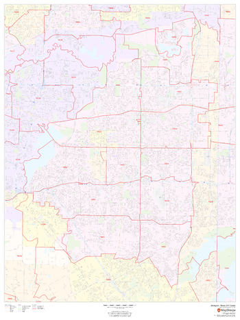
Arlington, Texas ZIP Codes
MapSherpa
This map of Arlington, Texas shows ZIP code areas overlaid on a road map. Ideal for planning of deliveries, home services, sales territories, real estate and much more. Base map features include all roads with major roads and highways labelled; neighborhood names; railways; and high level land use such as parks and recreation areas, industrial areas and hospital campuses.
Page Size: 36 x 48 in (914 x 1219 mm)
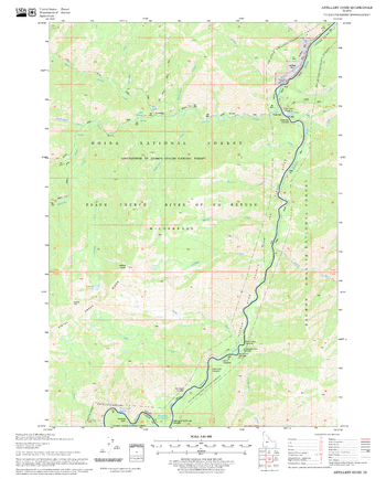
Artillery Dome Quadrangle, Idaho
United States Department of Agriculture Forest Service
United States Department of Agriculture Forestry Service topographical map of Artillery Dome, Salmon-Chalis National Forest, Idaho.
Page Size: 21.75 x 27 in (552 x 686 mm)
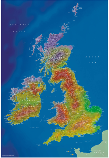
Artistic British Isles Wall Map
Cosmographics
British Isles mapping and vibrant colours combine to make this beautiful, colourful map with a difference.
Page Size: 22.5 x 32.75 in (570 x 830 mm)
No search results