


MapSherpa Catalog
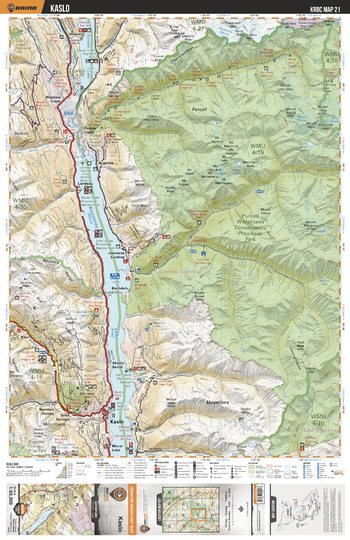
KRBC21 Kaslo - Kootenay Rockies BC Topo
Backroad Mapbooks
This recreation topographic map for the Kaslo area highlights all the logging and resource roads, multi-use trails for hikers, mountain bikers, horseback riders, cross-country skiers and snowshoers, motorized trails for ATVers and snowmobiles, fishing lakes and rivers, recreation areas, campgrounds, day-use areas, viewpoints, backcountry campsites, backcountry huts and cabins and more. No other map for the area provides you with this level of recreational or topographic detail. Special features include private land, labelled fish species and countless roads, trails and recreational Points of Interest. Covering 1,950 km2 (753 mi2), this 1:65,000 scale map measures 38 x 51 km (23.5 x 32 mi). This map includes Purcell Wilderness Conservancy Prov Park, Kootenay Lake, Kaslo, Birchdale, Lardeau, Howser, Duncan Lake, Meadow Creek, Johnsons Landing, Shutty Lake and more!
Page Size: 24 x 37 in (610 x 940 mm)
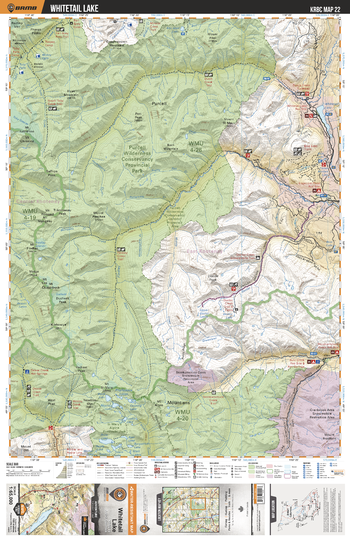
KRBC22 Whitetail Lake - Kootenay Rockies BC Topo
Backroad Mapbooks
This recreation topographic map for the Whitetail Lake area highlights all the logging and resource roads, multi-use trails for hikers, mountain bikers, horseback riders, cross-country skiers and snowshoers, motorized trails for ATVers and snowmobiles, fishing lakes and rivers, recreation areas, campgrounds, day-use areas, viewpoints, backcountry campsites, backcountry huts and cabins and more. No other map for the area provides you with this level of recreational or topographic detail. Special features include private land, labelled fish species and countless roads, trails and recreational Points of Interest. Covering 1,950 km2 (753 mi2), this 1:65,000 scale map measures 38 x 51 km (23.5 x 32 mi). This map includes Purcell Wilderness Conservancy Prov Park, Whitetail Lake, Doctor Creek, Buhl Creek, Skookumchuck Creek, Dewar Hot Springs, Dutch Creek, Findlay Creek, Skookumchuck Creek Tie Reserve, Blue Lake and more!
Page Size: 24 x 37 in (610 x 940 mm)
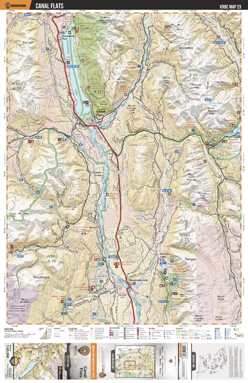
KRBC23 Canal Flats - Kootenay Rockies BC Topo
Backroad Mapbooks
This recreation topographic map for the Canal Flats area highlights all the logging and resource roads, multi-use trails for hikers, mountain bikers, horseback riders, cross-country skiers and snowshoers, motorized trails for ATVers and snowmobiles, fishing lakes and rivers, recreation areas, campgrounds, day-use areas, viewpoints, backcountry campsites, backcountry huts and cabins and more. No other map for the area provides you with this level of recreational or topographic detail. Special features include private land, labelled fish species and countless roads, trails and recreational Points of Interest. Covering 1,950 km2 (753 mi2), this 1:65,000 scale map measures 38 x 51 km (23.5 x 32 mi). This map includes Columbia Lake, Whiteswan Lake, Kootenay River, Premier Lake, Premier Lake Prov Park, Copper Creek, Skookumchuck, Canal Flats, Columbia Lake Wildlife Reserve, Alces (Moose) Lake and more!
Page Size: 24 x 37 in (610 x 940 mm)
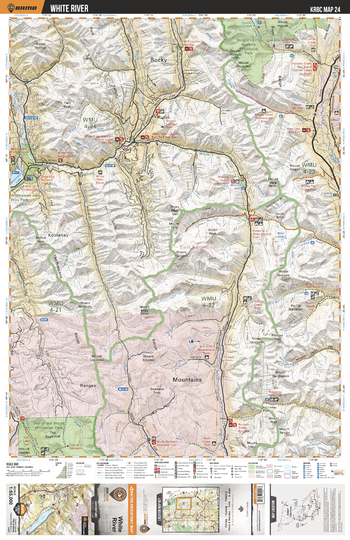
KRBC24 White River - Kootenay Rockies BC Topo
Backroad Mapbooks
This recreation topographic map for the White River area highlights all the logging and resource roads, multi-use trails for hikers, mountain bikers, horseback riders, cross-country skiers and snowshoers, motorized trails for ATVers and snowmobiles, fishing lakes and rivers, recreation areas, campgrounds, day-use areas, viewpoints, backcountry campsites, backcountry huts and cabins and more. No other map for the area provides you with this level of recreational or topographic detail. Special features include private land, labelled fish species and countless roads, trails and recreational Points of Interest. Covering 1,950 km2 (753 mi2), this 1:65,000 scale map measures 38 x 51 km (23.5 x 32 mi). This map includes Height of the Rockies Prov Park, Whiteswan Lake, Top of the World Prov Park, Hornaday Pass, Bull River, Elk River, White River, Forsyth Creek, Crossing Creek, Munroe Lake and more!
Page Size: 24 x 37 in (610 x 940 mm)
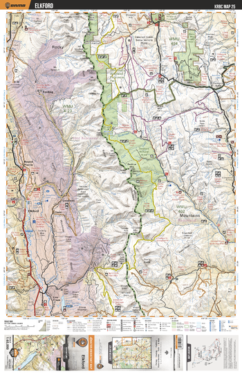
KRBC25 Elkford - Kootenay Rockies BC Topo
Backroad Mapbooks
This recreation topographic map for the Elkford area highlights all the logging and resource roads, multi-use trails for hikers, mountain bikers, horseback riders, cross-country skiers and snowshoers, motorized trails for ATVers and snowmobiles, fishing lakes and rivers, recreation areas, campgrounds, day-use areas, viewpoints, backcountry campsites, backcountry huts and cabins and more. No other map for the area provides you with this level of recreational or topographic detail. Special features include private land, labelled fish species and countless roads, trails and recreational Points of Interest. Covering 1,950 km2 (753 mi2), this 1:65,000 scale map measures 38 x 51 km (23.5 x 32 mi). This map includes Elkford, Don Getty Wildland Prov Park, Rocky Mtns, Line Creek, Grave Lake, Rocky Mtn Foothills, Cataract Creek, Oldman River, Fording, Fording River and more!
Page Size: 24 x 37 in (610 x 940 mm)
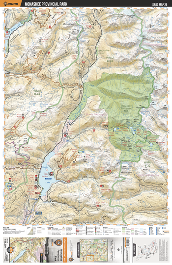
KRBC26 Monashee Provincial Park - Kootenay Rockies BC Topo
Backroad Mapbooks
This recreation topographic map for the Monashee Provincial Park area highlights all the logging and resource roads, multi-use trails for hikers, mountain bikers, horseback riders, cross-country skiers and snowshoers, motorized trails for ATVers and snowmobiles, fishing lakes and rivers, recreation areas, campgrounds, day-use areas, viewpoints, backcountry campsites, backcountry huts and cabins and more. No other map for the area provides you with this level of recreational or topographic detail. Special features include private land, labelled fish species and countless roads, trails and recreational Points of Interest. Covering 1,950 km2 (753 mi2), this 1:65,000 scale map measures 38 x 51 km (23.5 x 32 mi). This map includes Monashee Prov Park, Sugar Lake, Brenda Falls, Shuswap River, Sitkum Lake, Big Peters Lake, Little Peters Lake, Spectrum Lake, Mirror Lake, Mabel Lake and more!
Page Size: 24 x 37 in (610 x 940 mm)
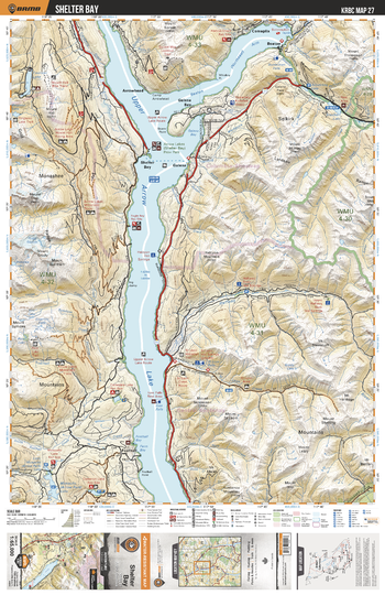
KRBC27 Shelter Bay - Kootenay Rockies BC Topo
Backroad Mapbooks
This recreation topographic map for the Shelter Bay area highlights all the logging and resource roads, multi-use trails for hikers, mountain bikers, horseback riders, cross-country skiers and snowshoers, motorized trails for ATVers and snowmobiles, fishing lakes and rivers, recreation areas, campgrounds, day-use areas, viewpoints, backcountry campsites, backcountry huts and cabins and more. No other map for the area provides you with this level of recreational or topographic detail. Special features include private land, labelled fish species and countless roads, trails and recreational Points of Interest. Covering 1,950 km2 (753 mi2), this 1:65,000 scale map measures 38 x 51 km (23.5 x 32 mi). This map includes Upper Arrow Lake, Fosthall, Arrowhead, Shelter Bay, Mosquito Lake, Staubert Lake, Coursier Lake, Beaton Arm, Galena, Comaplix and more!
Page Size: 24 x 37 in (610 x 940 mm)
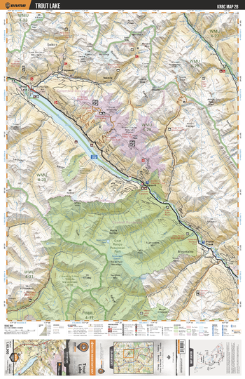
KRBC28 Trout Lake - Kootenay Rockies BC Topo
Backroad Mapbooks
This recreation topographic map for the Trout Lake area highlights all the logging and resource roads, multi-use trails for hikers, mountain bikers, horseback riders, cross-country skiers and snowshoers, motorized trails for ATVers and snowmobiles, fishing lakes and rivers, recreation areas, campgrounds, day-use areas, viewpoints, backcountry campsites, backcountry huts and cabins and more. No other map for the area provides you with this level of recreational or topographic detail. Special features include private land, labelled fish species and countless roads, trails and recreational Points of Interest. Covering 1,950 km2 (753 mi2), this 1:65,000 scale map measures 38 x 51 km (23.5 x 32 mi). This map includes Goat Range Prov Park, Trout Lake, Duncan River, Lardeau River, Great Norther Mtn, Fays Peak, Poplar Creek, Gold Hill, Gerrard, Goldhill and more!
Page Size: 24 x 37 in (610 x 940 mm)
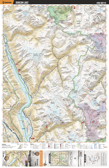
KRBC29 Duncan Lake - Kootenay Rockies BC Topo
Backroad Mapbooks
This recreation topographic map for the Duncan Lake area highlights all the logging and resource roads, multi-use trails for hikers, mountain bikers, horseback riders, cross-country skiers and snowshoers, motorized trails for ATVers and snowmobiles, fishing lakes and rivers, recreation areas, campgrounds, day-use areas, viewpoints, backcountry campsites, backcountry huts and cabins and more. No other map for the area provides you with this level of recreational or topographic detail. Special features include private land, labelled fish species and countless roads, trails and recreational Points of Interest. Covering 1,950 km2 (753 mi2), this 1:65,000 scale map measures 38 x 51 km (23.5 x 32 mi). This map includes Duncan Lake, MacBeth Icefield, Lake of the Hanging Glacier, Horsethief Falls, The Bugaboos, Bugaboo Prov Park, Howser Creek, The Four Squatters and more!
Page Size: 24 x 37 in (610 x 940 mm)
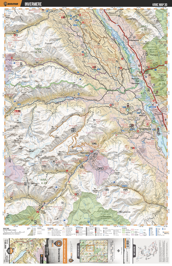
KRBC30 Invermere - Kootenay Rockies BC Topo
Backroad Mapbooks
This recreation topographic map for the Invermere area highlights all the logging and resource roads, multi-use trails for hikers, mountain bikers, horseback riders, cross-country skiers and snowshoers, motorized trails for ATVers and snowmobiles, fishing lakes and rivers, recreation areas, campgrounds, day-use areas, viewpoints, backcountry campsites, backcountry huts and cabins and more. No other map for the area provides you with this level of recreational or topographic detail. Special features include private land, labelled fish species and countless roads, trails and recreational Points of Interest. Covering 1,950 km2 (753 mi2), this 1:65,000 scale map measures 38 x 51 km (23.5 x 32 mi). This map includes Windermere Lake, Edgewater, Radium Hot Springs, Shuswap, Invermere, Columbia River, Purcell Wilderness Conservancy Prov Park, Welsh Lake, Kootenay National Park and more!
Page Size: 24 x 37 in (610 x 940 mm)
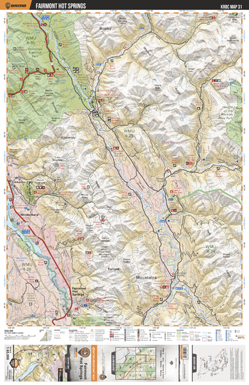
KRBC31 Fairmont Hot Springs - Kootenay Rockies BC Topo
Backroad Mapbooks
This recreation topographic map for the Fairmont Hot Springs area highlights all the logging and resource roads, multi-use trails for hikers, mountain bikers, horseback riders, cross-country skiers and snowshoers, motorized trails for ATVers and snowmobiles, fishing lakes and rivers, recreation areas, campgrounds, day-use areas, viewpoints, backcountry campsites, backcountry huts and cabins and more. No other map for the area provides you with this level of recreational or topographic detail. Special features include private land, labelled fish species and countless roads, trails and recreational Points of Interest. Covering 1,950 km2 (753 mi2), this 1:65,000 scale map measures 38 x 51 km (23.5 x 32 mi). This map includes Kootenay National Park, Kootenay River, Palliser River, Windermere Lake, Columbia River, Albert River, Fairmont Hot Springs, Windermere, Height of the Rockies Prov Park, Swansea Mtn and more!
Page Size: 24 x 37 in (610 x 940 mm)
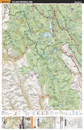
KRBC32 Elk Lakes Provincial Park - Kootenay Rockies BC Topo
Backroad Mapbooks
This recreation topographic map for the Elk Lakes Provincial Park area highlights all the logging and resource roads, multi-use trails for hikers, mountain bikers, horseback riders, cross-country skiers and snowshoers, motorized trails for ATVers and snowmobiles, fishing lakes and rivers, recreation areas, campgrounds, day-use areas, viewpoints, backcountry campsites, backcountry huts and cabins and more. No other map for the area provides you with this level of recreational or topographic detail. Special features include private land, labelled fish species and countless roads, trails and recreational Points of Interest. Covering 1,950 km2 (753 mi2), this 1:65,000 scale map measures 38 x 51 km (23.5 x 32 mi). This map includes Elk Lakes Prov Park, Upper Kananaskis Lake, Lower Kananaskis Lake, Elbow-Sheep Wildland Prov Park, Height of the Rockies Prov Park, Banff National Park, Connor Lakes, Elk River, White River, Peter Lougheed Prov Park and more!
Page Size: 24 x 37 in (610 x 940 mm)
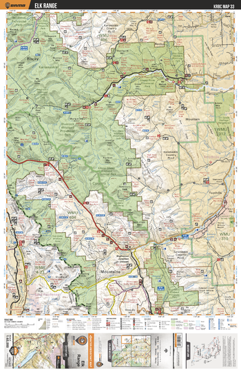
KRBC33 Elk Range - Kootenay Rockies BC Topo
Backroad Mapbooks
This recreation topographic map for the Elk Range area highlights all the logging and resource roads, multi-use trails for hikers, mountain bikers, horseback riders, cross-country skiers and snowshoers, motorized trails for ATVers and snowmobiles, fishing lakes and rivers, recreation areas, campgrounds, day-use areas, viewpoints, backcountry campsites, backcountry huts and cabins and more. No other map for the area provides you with this level of recreational or topographic detail. Special features include private land, labelled fish species and countless roads, trails and recreational Points of Interest. Covering 1,950 km2 (753 mi2), this 1:65,000 scale map measures 38 x 51 km (23.5 x 32 mi). This map includes Bluerock Wildland Prov Park, Elk River, Highwood River, Sheep River Prov Park, Don Getty Wildland Prov Park, Highwood House, Sheep River, Elbow River, Elk Range, Baril Creek and more!
Page Size: 24 x 37 in (610 x 940 mm)
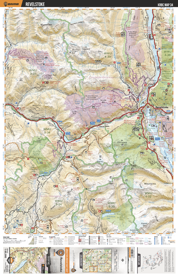
KRBC34 Revelstoke - Kootenay Rockies BC Topo
Backroad Mapbooks
This recreation topographic map for the Revelstoke area highlights all the logging and resource roads, multi-use trails for hikers, mountain bikers, horseback riders, cross-country skiers and snowshoers, motorized trails for ATVers and snowmobiles, fishing lakes and rivers, recreation areas, campgrounds, day-use areas, viewpoints, backcountry campsites, backcountry huts and cabins and more. No other map for the area provides you with this level of recreational or topographic detail. Special features include private land, labelled fish species and countless roads, trails and recreational Points of Interest. Covering 1,950 km2 (753 mi2), this 1:65,000 scale map measures 38 x 51 km (23.5 x 32 mi). This map includes Upper Arrow Lake, Lake Revelstoke, Revelstoke, Clanwilliam, Big Eddy, Three Valley, Eagle River, Greenbush Lake, Boulder Mtn, Frisby Ridge and more!
Page Size: 24 x 37 in (610 x 940 mm)
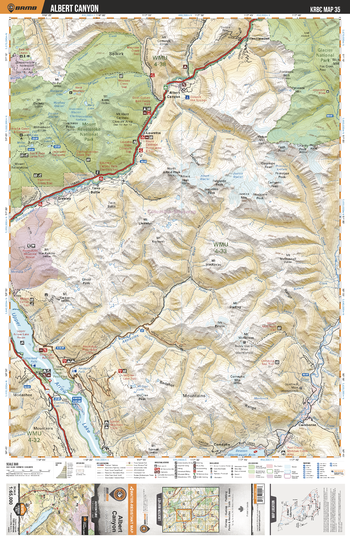
KRBC35 Albert Canyon - Kootenay Rockies BC Topo
Backroad Mapbooks
This recreation topographic map for the Albert Canyon area highlights all the logging and resource roads, multi-use trails for hikers, mountain bikers, horseback riders, cross-country skiers and snowshoers, motorized trails for ATVers and snowmobiles, fishing lakes and rivers, recreation areas, campgrounds, day-use areas, viewpoints, backcountry campsites, backcountry huts and cabins and more. No other map for the area provides you with this level of recreational or topographic detail. Special features include private land, labelled fish species and countless roads, trails and recreational Points of Interest. Covering 1,950 km2 (753 mi2), this 1:65,000 scale map measures 38 x 51 km (23.5 x 32 mi). This map includes Mount Revelstoke National Park, Albert Canyon, Greeley, Upper Arrow Lake, Camborne, Incomappleux River, Glacier National Park, Illecillewaet, Twin Butte, Lauretta and more!
Page Size: 24 x 37 in (610 x 940 mm)
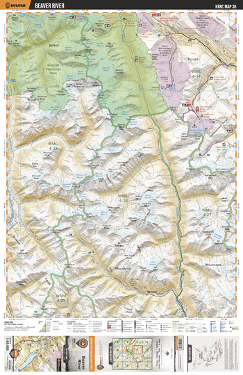
KRBC36 Beaver River - Kootenay Rockies BC Topo
Backroad Mapbooks
This recreation topographic map for the Beaver River area highlights all the logging and resource roads, multi-use trails for hikers, mountain bikers, horseback riders, cross-country skiers and snowshoers, motorized trails for ATVers and snowmobiles, fishing lakes and rivers, recreation areas, campgrounds, day-use areas, viewpoints, backcountry campsites, backcountry huts and cabins and more. No other map for the area provides you with this level of recreational or topographic detail. Special features include private land, labelled fish species and countless roads, trails and recreational Points of Interest. Covering 1,950 km2 (753 mi2), this 1:65,000 scale map measures 38 x 51 km (23.5 x 32 mi). This map includes Glacier National Park, Duncan River, Spillimacheen River, Silent Mtn, Beaver River, Bobbie Burns Creek, McMurdo Creek and more!
Page Size: 24 x 37 in (610 x 940 mm)
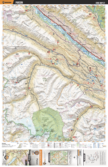
KRBC37 Parson - Kootenay Rockies BC Topo
Backroad Mapbooks
This recreation topographic map for the Parson area highlights all the logging and resource roads, multi-use trails for hikers, mountain bikers, horseback riders, cross-country skiers and snowshoers, motorized trails for ATVers and snowmobiles, fishing lakes and rivers, recreation areas, campgrounds, day-use areas, viewpoints, backcountry campsites, backcountry huts and cabins and more. No other map for the area provides you with this level of recreational or topographic detail. Special features include private land, labelled fish species and countless roads, trails and recreational Points of Interest. Covering 1,950 km2 (753 mi2), this 1:65,000 scale map measures 38 x 51 km (23.5 x 32 mi). This map includes Horse Creek, McMurdo, Parson, Castledale, Seeney, Yoho National Park, Columbia River, Bugaboo Prov Park, Warren Creek, Spillimacheen River and more!
Page Size: 24 x 37 in (610 x 940 mm)
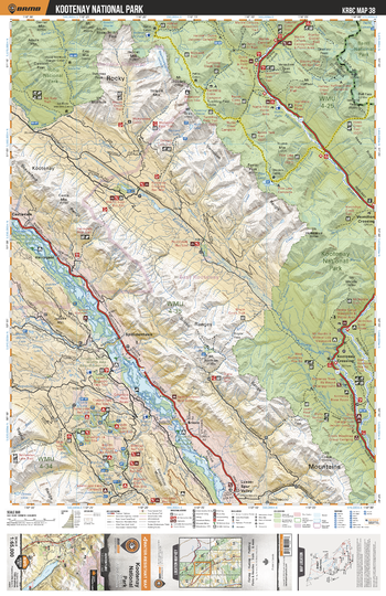
KRBC38 Kootenay National Park - Kootenay Rockies BC Topo
Backroad Mapbooks
This recreation topographic map for the Kootenay National Park area highlights all the logging and resource roads, multi-use trails for hikers, mountain bikers, horseback riders, cross-country skiers and snowshoers, motorized trails for ATVers and snowmobiles, fishing lakes and rivers, recreation areas, campgrounds, day-use areas, viewpoints, backcountry campsites, backcountry huts and cabins and more. No other map for the area provides you with this level of recreational or topographic detail. Special features include private land, labelled fish species and countless roads, trails and recreational Points of Interest. Covering 1,950 km2 (753 mi2), this 1:65,000 scale map measures 38 x 51 km (23.5 x 32 mi). This map includes Columbia River, Kootenay National Park, Vermillion River, Kootenay River, Kootenay Crossing, Yoho National Park, Spillimacheen, Floe Lake, Kootenay Ranges, Luxor-Spur Valley and more!
Page Size: 24 x 37 in (610 x 940 mm)
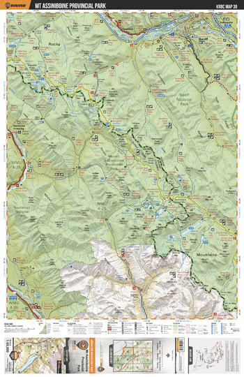
KRBC39 Mt Assiniboine Prov Park - Kootenay Rockies BC Topo
Backroad Mapbooks
This recreation topographic map for the Mt Assiniboine Prov Park area highlights all the logging and resource roads, multi-use trails for hikers, mountain bikers, horseback riders, cross-country skiers and snowshoers, motorized trails for ATVers and snowmobiles, fishing lakes and rivers, recreation areas, campgrounds, day-use areas, viewpoints, backcountry campsites, backcountry huts and cabins and more. No other map for the area provides you with this level of recreational or topographic detail. Special features include private land, labelled fish species and countless roads, trails and recreational Points of Interest. Covering 1,950 km2 (753 mi2), this 1:65,000 scale map measures 38 x 51 km (23.5 x 32 mi). This map includes Banff National Park, Mount Assiniboine Prov Park, Marvel Lake, Banff, Sawback, Kootenay River, Bow River, Anthracite, Kootenay National Park and more!
Page Size: 24 x 37 in (610 x 940 mm)
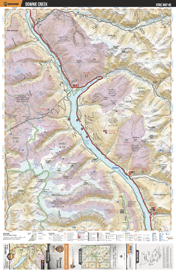
KRBC40 Downie Creek - Kootenay Rockies BC Topo
Backroad Mapbooks
This recreation topographic map for the Downie Creek area highlights all the logging and resource roads, multi-use trails for hikers, mountain bikers, horseback riders, cross-country skiers and snowshoers, motorized trails for ATVers and snowmobiles, fishing lakes and rivers, recreation areas, campgrounds, day-use areas, viewpoints, backcountry campsites, backcountry huts and cabins and more. No other map for the area provides you with this level of recreational or topographic detail. Special features include private land, labelled fish species and countless roads, trails and recreational Points of Interest. Covering 1,950 km2 (753 mi2), this 1:65,000 scale map measures 38 x 51 km (23.5 x 32 mi). This map includes Lake Revelstoke, Downie Arm, Goldstream River, Downie Creek, Keystone Peak, Carnes Creek and more!
Page Size: 24 x 37 in (610 x 940 mm)
No search results