


MapSherpa Catalog
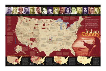
Indian Country
National Geographic
For five centuries, Indian territories have been contested on battlefields, legislated in Congress, and studied in classrooms. This updated map shows Indian reservations, tribal entities, trust lands, and locations of major festivals and pow-wows. Also includes photos and short biographies of notable Indians through history, and a series of four maps showing how Native American lands have lost territory from 1775 to the present. An excellent complement to our Indian Cultures of North America map.
Page Size: 35 x 23.5 in (889 x 597 mm)
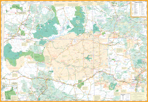
Indian Country Map
GM Johnson
Indian Country / Four Corners (AZ,CO,NM,UT) Road Map. Map Coverage Area: Chaco Culture & Mesa Verde. Also Includes Descriptive Text of Communities, Points of Interest
Page Size: 39.5 x 27.25 in (1003 x 692 mm)
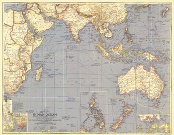
Indian Ocean - Published 1941
National Geographic
This World War II era map contains great detail about the Indian Ocean region including typical storm tracks, naval bases, and historical notes. Published in March 1941, this map is a great companion for the map of the Pacific in 1936.
Page Size: 32.25 x 25.25 in (819 x 636 mm)
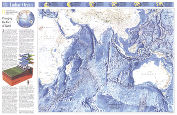
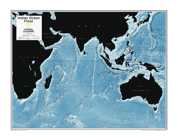
Indian Ocean - Published 1992
National Geographic
This attractive physical map of the Indian Ocean floor appeared in the June 1992 issue of National Geographic. It contains an article entitled "Changing the Face of Earth" and additional information on continental drift. The map's detail of such submarine terrain as fracture zones, basins, and ridges is stunning. A wonderful companion to the ocean floor map of the Pacific Ocean which appeared in the same issue.
Page Size: 31.5 x 20.5 in (796 x 517 mm)
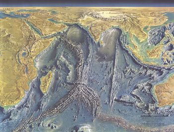
Indian Ocean Floor - Published 1967
National Geographic
This distinctive physical map of the Indian Ocean floor appeared in the October 1967 issue of National Geographic. The detail of such submarine terrain as continental shelves, basins, fracture zones and the mighty Mid-Oceanic Ridge is stunning. A true work of art, and a wonderful companion to the ocean floor maps of the Atlantic (1968), Pacific (1969), and Arctic (1971).
Page Size: 24.75 x 19 in (628 x 478 mm)
Indian Ocean Floor - Atlas of the World, 10th Edition
National Geographic
null
Page Size: 28 x 22 in (711 x 559 mm)

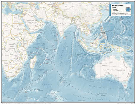
Indian Ocean Floor - Atlas of the World, 11th Edition
National Geographic
This map of physical ocean seafloor can fit in any space. Showcasing the Indian Ocean floor in stunning detail with state-of-the-art cartographic techniques delivering accuracy and exceptional quality, the innovative and engaging design makes the content easily accessible and user-friendly.
Ideal for classrooms with an emphasis on teaching geography or environmental themes. The mapping of the ocean terrain gives your students a unique glimpse into how our world appears under the sea.
This physical map of the Indian Ocean floor uses stunning contrasts to highlight the ocean floor and its physical features. This map is drawn in the Miller Cylindrical projection, an adapted version of the Mercator projection for nautical navigation because it represents lines of constant course, known as rhumb lines or loxodromes, as straight segments that conserve the angles with the meridians.
This map is found in National Geographic's 11th Edition World Atlas and is now available as a stand alone product.
Page Size: 31.5 x 24 in (798 x 610 mm)
Indian Ocean Floor - Atlas of the World, 11th Edition - Compact
National Geographic
This map of physical ocean seafloor can fit in any space. Showcasing the Indian Ocean floor in stunning detail with state-of-the-art cartographic techniques delivering accuracy and exceptional quality, the innovative and engaging design makes the content easily accessible and user-friendly.
Ideal for classrooms with an emphasis on teaching geography or environmental themes. The mapping of the ocean terrain gives your students a unique glimpse into how our world appears under the sea.
This physical map of the Indian Ocean floor uses stunning contrasts to highlight the ocean floor and its physical features. This map is drawn in the Miller Cylindrical projection, an adapted version of the Mercator projection for nautical navigation because it represents lines of constant course, known as rhumb lines or loxodromes, as straight segments that conserve the angles with the meridians.
This map is found in National Geographic's 11th Edition World Atlas and is now available as a stand alone product.
Page Size: 21.5 x 16.25 in (540 x 413 mm)

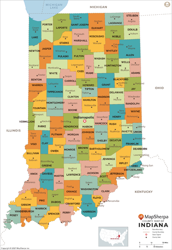
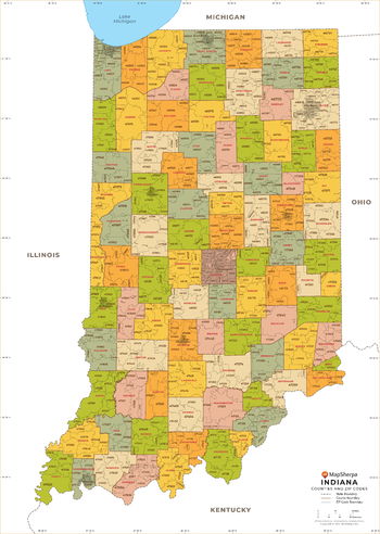
Indiana Counties Map - Extra Large
MapSherpa
This map has been created exclusively for MapSherpa, and designed for reference or business use. Clear and clean colors & fonts matched with cartographic research makes this map of Indiana Counties Map easily readable and useful. The map shows the 92 counties of Indiana and their borders across the Hoosier State.
Page Size: 60 x 87.25 in (1524 x 2211 mm)
Indiana Counties Map - Large
MapSherpa
This map has been created exclusively for MapSherpa, and designed for reference or business use. Clear and clean colors & fonts matched with cartographic research makes this map of Indiana Counties Map easily readable and useful. The map shows the 92 counties of Indiana and their borders across the Hoosier State.
Page Size: 48 x 69.75 in (1219 x 1769 mm)

Indiana Counties Map - Standard
MapSherpa
This map has been created exclusively for MapSherpa, and designed for reference or business use. Clear and clean colors & fonts matched with cartographic research makes this map of Indiana Counties Map easily readable and useful. The map shows the 92 counties of Indiana and their borders across the Hoosier State.
Page Size: 36 x 52.25 in (914 x 1326 mm)
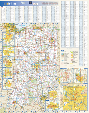
Indiana State Wall Map
Globe Turner
This colorful, easy-to-read state map of Indiana identifies all major thoroughfares, secondary roads, freeway interchanges, rest areas, distance markers, landmarks, recreational areas, and more. Shaded relief on the state map provides a three-dimensional sense of Indiana's topography. Detailed city inset maps of Bloomington, Elkhart, Evansville, Fort Wayne, Indianapolis, Lafayette, Muncie, South Bend and Terre Haute are based on the latest street information from our cartographic experts. An inset of downtown Indianapolis provides must-see information on the central business district. County and city indices make it simple to locate even the smallest town.
Page Size: 20.5 x 26 in (521 x 660 mm)
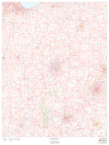
Indiana ZIP Code Map
MapSherpa
This map of Indiana shows ZIP codes overlaid on a road map. Base map features include municipality and county boundaries, major road network features, and state and national parks and conservation areas.
Page Size: 36 x 48 in (914 x 1219 mm)
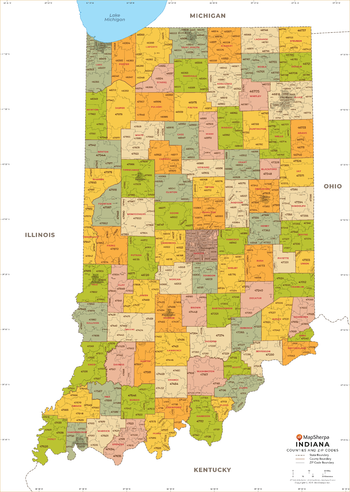
Indiana ZIP Code Map with Counties - Extra Large
MapSherpa
This map has been created exclusively for MapSherpa, and designed for business or reference use. Clear and clean colors & fonts matched with cartographic research makes this Indiana Zip Code Map with Counties easily readable and useful. The map shows the 92 counties of Indiana and the borders of the 773 zip codes across the Hoosier State.
Page Size: 60 x 84.5 in (1524 x 2141 mm)
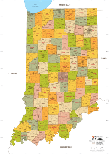
Indiana ZIP Code Map with Counties - Large
MapSherpa
This map has been created exclusively for MapSherpa, and designed for business or reference use. Clear and clean colors & fonts matched with cartographic research makes this Indiana Zip Code Map with Counties easily readable and useful. The map shows the 92 counties of Indiana and the borders of the 773 zip codes across the Hoosier State.
Page Size: 48 x 67.5 in (1219 x 1713 mm)
Indiana ZIP Code Map with Counties - Standard
MapSherpa
This map has been created exclusively for MapSherpa, and designed for business or reference use. Clear and clean colors & fonts matched with cartographic research makes this Indiana Zip Code Map with Counties easily readable and useful. The map shows the 92 counties of Indiana and the borders of the 773 zip codes across the Hoosier State.
Page Size: 36 x 50.75 in (914 x 1285 mm)
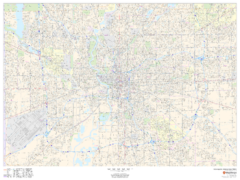
Indianapolis, Indiana Inner Metro - Landscape
MapSherpa
This landscape-oriented map of central Indianapolis, Indiana shows detailed street level information including extensive street labeling. Ideal for planning of deliveries, home services, sales territories, real estate and much more. Base map features include all roads with major roads and highways labelled; neighborhood names; railways; high level land use such as parks and recreation areas, industrial areas and hospital campuses; and a variety of points of interest including schools, libraries, stadiums, museums, border crossings and more.
Page Size: 48 x 36 in (1219 x 914 mm)
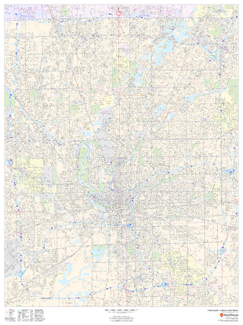
Indianapolis, Indiana Inner Metro - Portrait
MapSherpa
This portrait-oriented map of central Indianapolis, Indiana shows detailed street level information including extensive street labeling. Ideal for planning of deliveries, home services, sales territories, real estate and much more. Base map features include all roads with major roads and highways labelled; neighborhood names; railways; high level land use such as parks and recreation areas, industrial areas and hospital campuses; and a variety of points of interest including schools, libraries, stadiums, museums, border crossings and more.
Page Size: 36 x 48 in (914 x 1219 mm)
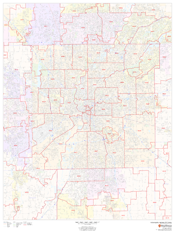
Indianapolis, Indiana ZIP Codes
MapSherpa
This map of Indianapolis shows ZIP code areas overlaid on a road map. Ideal for planning of deliveries, home services, sales territories, real estate and much more. Base map features include all roads with major roads and highways labelled; neighborhood names; railways; and high level land use such as parks and recreation areas, industrial areas and hospital campuses.
Page Size: 36 x 48 in (914 x 1219 mm)
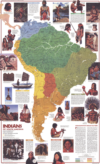
Indians of South America - Published 1982
National Geographic
Discover the fascinating pre-Columbian cultures of the Amazon, the Andes, and beyond. This map captures the essence of the diverse tribes of the continent with informative profiles and colorful illustrations. Published in March 1982 as a companion to the "Archaeology of South America" map.
Page Size: 22.75 x 37 in (573 x 938 mm)
No search results