XYZ Maps
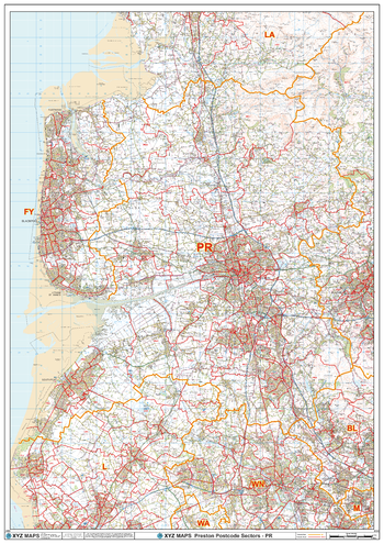
Preston - PR - Postcode Wall Map
The Preston Postcode Sector Wall Map shows detailed postcode sector boundaries (PR1 1, PR1 2) on a comprehensive background and is perfect for determining postcode boundaries for sales areas, planning mailshots and also an excellent reference for logistics. This wall map covers the whole of the PR Postcode Area.
Page Size: 33.25 x 47 in (841 x 1189 mm)
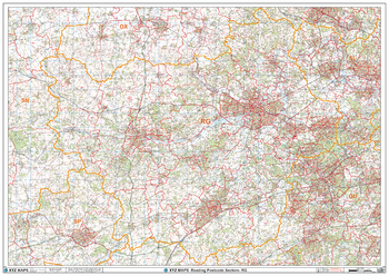
Reading - RG - Postcode Wall Map
The Reading Postcode Sector Wall Map shows detailed postcode sector boundaries (RG1 1, RG1 2) on a comprehensive background and is perfect for determining postcode boundaries for sales areas, planning mailshots and also an excellent reference for logistics. This wall map covers the whole of the RG Postcode Area.
Page Size: 47 x 33.25 in (1189 x 841 mm)
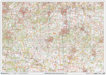
Redhill - RH - Postcode Wall Map
The Redhill Postcode Sector Wall Map shows detailed postcode sector boundaries (RH1 1, RH1 2) on a comprehensive background and is perfect for determining postcode boundaries for sales areas, planning mailshots and also an excellent reference for logistics. This wall map covers the whole of the RH Postcode Area.
Page Size: 47 x 33.25 in (1189 x 841 mm)
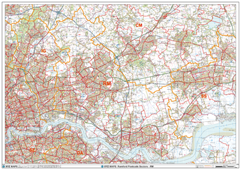
Romford - RM - Postcode Wall Map
The Romford Postcode Sector Wall Map shows detailed postcode sector boundaries (RM1 1, RM1 2) on a comprehensive background and is perfect for determining postcode boundaries for sales areas, planning mailshots and also an excellent reference for logistics. This wall map covers the whole of the RM Postcode Area.
Page Size: 47 x 33.25 in (1189 x 841 mm)
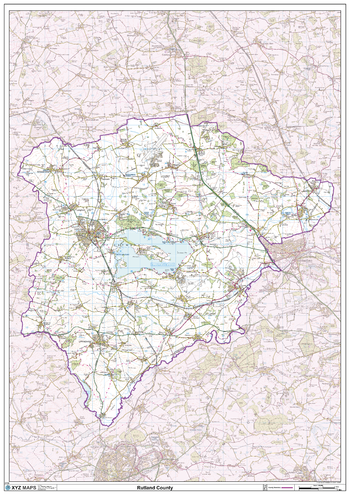
Rutland County Map
This is a large ceremonial county map of Rutland highlighting the county border, with the surrounding area faded out for excellent contrast. The map covers Oakham and Uppingham. The county map shows the latest County and Unitary Authority Boundaries, Overlaid on a Clear and Easy to Read Ordnance Survey map.
Page Size: 33.25 x 47 in (841 x 1189 mm)
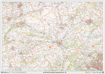
Salisbury - SP - Postcode Wall Map
The Salisbury Postcode Sector Wall Map shows detailed postcode sector boundaries (SP1 1, SP1 2) on a comprehensive background and is perfect for determining postcode boundaries for sales areas, planning mailshots and also an excellent reference for logistics. This wall map covers the whole of the SP Postcode Area.
Page Size: 47 x 33.25 in (1189 x 841 mm)
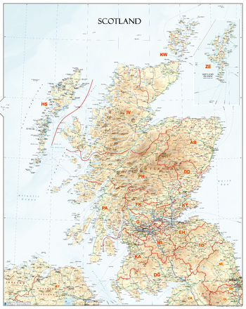
Scotland Postcode Areas Wall Map (A1)
An informative physical wall map of Scotland ideal for the office or educational environment. This unique map accurately depicts relief. Includes all major towns, roads, rivers, lakes and clearly shows the postcode area boundaries along with the associated postcode Labels.
Page Size: 27.75 x 34.75 in (700 x 880 mm)
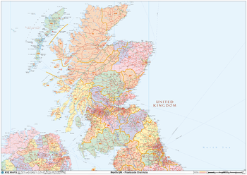
Scotland Postcode District Wall Map (D10)
The Scotland Postcode District Wall Map clearly shows postcode district boundaries and associated district labels (EH1, EH2) on a comprehensive background and is perfect for determining postcode boundaries for sales territories, logistics, planning mailshots or as a regional reference guide.
Page Size: 47 x 33.25 in (1189 x 841 mm)
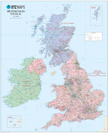
Scottish British Isles Political Wall Map
The Scottish British Isles Political wall map is ideal for the office or educational environment. This unique Scottish British Isles map features political colouring showing the Counties of the United Kingdon of England, Wales & Northern Ireland (rUK), Scotland and Ireland. All major Towns, Roads, Rivers and Lakes are shown on this map. This map shows the British Isles as they would appear if Scotland became independent. If you are a YES supporter in favour of independence for Scotland then this is the map for you!
Page Size: 35.5 x 43.5 in (900 x 1100 mm)
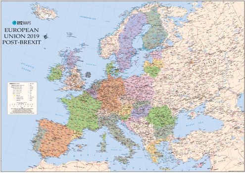
Scottish Catalan European Union 2019 - Post Brexit Wall Map
The Scottish Catalan European Union 2019 Post-Brexit Political wall map is ideal for the office or educational environment. This unique Scottish EU map features political colouring showing Europe and the member countries of the European Union. All major Towns, Roads, Rivers and Lakes are shown on this map. This map shows the British Isles as they would appear if Scotland became independent and chose to remain in the EU. It also shows Catalonia / Catalunya as independent within the EU. If you are a YES supporter in favour of independence for Scotland then this is the map for you!
Page Size: 47 x 33.25 in (1189 x 841 mm)
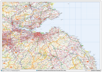
Scottish Central Belt East Postcode Sector Wall Map (S18)
The Scottish Central Belt East Postcode Sector Wall Map shows detailed postcode sector boundaries along with its associated label (EH1 1, EH1 2) on a comprehensive background and is perfect for determining postcode boundaries, for sales, logistics, planning mailshots or as a regional reference guide.
Page Size: 47 x 33.25 in (1189 x 841 mm)
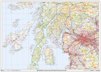
Scottish Central Belt West Postcode Sector Wall Map (S17)
The Scottish Central Belt West Postcode Sector Wall Map shows detailed postcode sector boundaries along with its associated label (G1 1, G1 2) on a comprehensive background and is perfect for determining postcode boundaries, for sales, logistics, planning mailshots or as a regional reference guide.
Page Size: 47 x 33.25 in (1189 x 841 mm)
Scottish Large World Political Wall Map
Stunning Large Scottish World Wall Map, ideal for the Boardroom, Office, Home or Educational environment. This Large World Wall Map features vibrant political colouring showing the countries and cities of the world with accurate hill shading. The large size Scottish Political World Wall Map includes Flags and Country information and shows Scotland as an independent country along with rUK (the United Kingdom of England, Wales & Northern Ireland). If you are a YES supporter in favour of independence for Scotland then this is the map for you!
Page Size: 54 x 38 in (1370 x 960 mm)
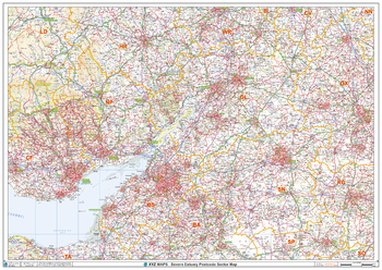
Severn Estuary Postcode Sector Wall Map (S6)
The Severn Estuary Postcode Sector Wall Map shows detailed postcode sector boundaries along with its associated label (BS1 1, BS1 2) on a comprehensive background and is perfect for determining postcode boundaries, for sales, logistics, planning mailshots or as a regional reference guide.
Page Size: 47 x 33.25 in (1189 x 841 mm)
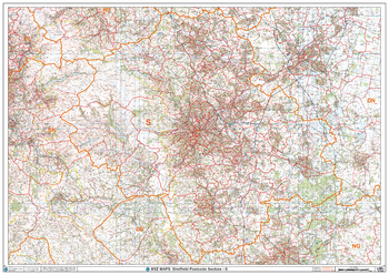
Sheffield - S - Postcode Wall Map
The Sheffield Postcode Sector Wall Map shows detailed postcode sector boundaries (S1 1, S1 2) on a comprehensive background and is perfect for determining postcode boundaries for sales areas, planning mailshots and also an excellent reference for logistics. This wall map covers the whole of the S Postcode Area.
Page Size: 47 x 33.25 in (1189 x 841 mm)
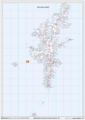
Shetland - ZE - Postcode Wall Map
The Shetland Postcode Sector Wall Map shows detailed postcode sector boundaries (ZE1 1, ZE1 2) on a comprehensive background and is perfect for determining postcode boundaries for sales areas, planning mailshots and also an excellent reference for logistics. This wall map covers the whole of the ZE Postcode Area.
Page Size: 33.25 x 47 in (841 x 1189 mm)
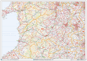
Shrewsbury - SY - Postcode Wall Map
The Shrewsbury Postcode Sector Wall Map shows detailed postcode sector boundaries (SY1 1, SY1 2) on a comprehensive background and is perfect for determining postcode boundaries for sales areas, planning mailshots and also an excellent reference for logistics. This wall map covers the whole of the SY Postcode Area.
Page Size: 47 x 33.25 in (1189 x 841 mm)
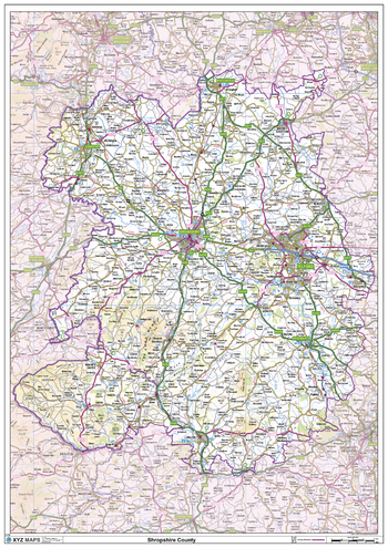
Shropshire County Map
This is a large ceremonial county map of Shropshire highlighting the county border, with the surrounding area faded out for excellent contrast. The map covers Bishops Castle, Bridgnorth, Church Stretton, Dawley, Donnington, Ellesmere, Ludlow, Coalbrookedale, Newport, Oswestry, Shrewsbury and Telford. The county map shows the latest County and Unitary Authority Boundaries, Overlaid on a Clear and Easy to Read Ordnance Survey map.
Page Size: 33.25 x 47 in (841 x 1189 mm)
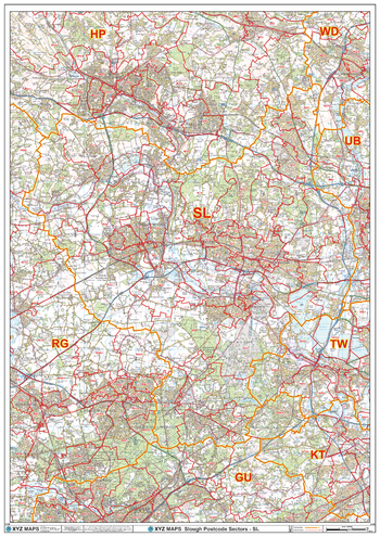
Slough - SL - Postcode Wall Map
The Slough Postcode Sector Wall Map shows detailed postcode sector boundaries (SL1 1, SL1 2) on a comprehensive background and is perfect for determining postcode boundaries for sales areas, planning mailshots and also an excellent reference for logistics. This wall map covers the whole of the SL Postcode Area.
Page Size: 33.25 x 47 in (841 x 1189 mm)
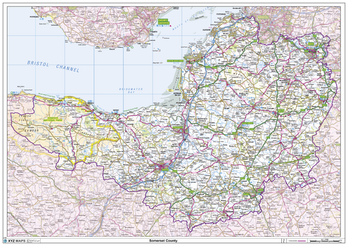
Somerset County Map
This is a large ceremonial county map of Somerset highlighting the county border, with the surrounding area faded out for excellent contrast. The map covers Bath, Bristol, Burnham-on-Sea, Clevedon, Glastonbury, Minehead, Shepton Mallett, Somerton, Taunton, Wells, Weston-Super-Mare and Yeovil. The county map shows the latest County and Unitary Authority Boundaries, Overlaid on a Clear and Easy to Read Ordnance Survey map.
Page Size: 47 x 33.25 in (1189 x 841 mm)