The Times
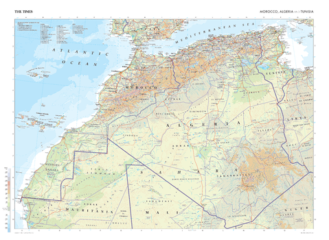
The Times Map of Morocco, Algeria and Tunisia
This map of Morocco, Algeria, and Tunisia stands as a benchmark of cartographic excellence, sourced from the industry-leading Times Comprehensive Atlas of the World. Published in full colour, this map offers a comprehensive and updated view of the landscapes that are found in this region. Prominent features such as the historic cities of Marrakech and Algiers are clearly identifiable, as is the vast Sahara Desert. With meticulous attention to detail, this map is an indispensable guide to the geographic intricacies of Morocco, Algeria, and Tunisia.
Page Size: 36.5 x 26.75 in (924 x 675 mm)
The Times Map of Morocco, Algeria and Tunisia - Compact
This map of Morocco, Algeria, and Tunisia stands as a benchmark of cartographic excellence, sourced from the industry-leading Times Comprehensive Atlas of the World. Published in full colour, this map offers a comprehensive and updated view of the landscapes that are found in this region. Prominent features such as the historic cities of Marrakech and Algiers are clearly identifiable, as is the vast Sahara Desert. With meticulous attention to detail, this map is an indispensable guide to the geographic intricacies of Morocco, Algeria, and Tunisia.
Page Size: 22.25 x 16.25 in (561 x 410 mm)

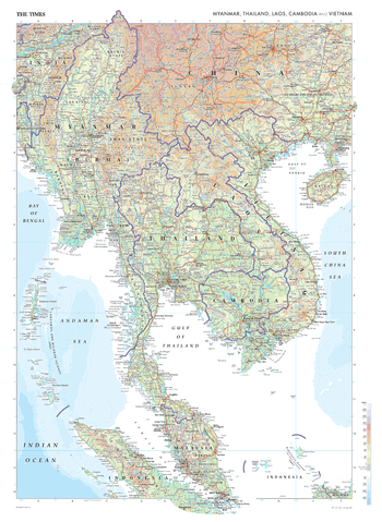
The Times Map of Myanmar, Thailand, Laos and Vietnam
This map of Myanmar, Thailand, Laos, Cambodia and Vietnam stands as a benchmark of cartographic excellence, sourced from the industry-leading Times Comprehensive Atlas of the World. With its full colour presentation, the map offers a detailed and updated portrayal of this region. Prominent geographical features and boundaries are distinctly marked, enabling easy identification of countries such as Myanmar, Thailand, Laos, Cambodia and Vietnam. Urban centres such as Bangkok, Singapore and Kuala Lumpur are also clearly visible. Through its careful selection of elements, this map serves as an artistic and informative guide to the geographical landscape of Myanmar, Thailand, Laos, Cambodia and Vietnam.
Page Size: 26.75 x 36.5 in (675 x 924 mm)
The Times Map of Myanmar, Thailand, Laos and Vietnam - Compact
This map of Myanmar, Thailand, Laos, Cambodia and Vietnam stands as a benchmark of cartographic excellence, sourced from the industry-leading Times Comprehensive Atlas of the World. With its full colour presentation, the map offers a detailed and updated portrayal of this region. Prominent geographical features and boundaries are distinctly marked, enabling easy identification of countries such as Myanmar, Thailand, Laos, Cambodia and Vietnam. Urban centres such as Bangkok, Singapore and Kuala Lumpur are also clearly visible. Through its careful selection of elements, this map serves as an artistic and informative guide to the geographical landscape of Myanmar, Thailand, Laos, Cambodia and Vietnam.
Page Size: 16.25 x 22.25 in (410 x 561 mm)
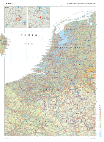
The Times Map of Netherlands, Belgium and Luxembourg
This map of the Benelux countries stands as a benchmark of cartographic excellence, sourced from the industry-leading Times Comprehensive Atlas of the World. Published in full colour, this map offers a comprehensive and updated view of the landscapes that are found in this region. Encompassing Belgium, the Netherlands, and Luxembourg, this map includes prominent features such as the historic cities of Amsterdam and Brussels, the flat lowlands, and key landmarks. Notably, the map includes inset maps of Amsterdam and Brussels, adding an extra layer of detail to these vibrant urban centres. With meticulous attention to detail, this map is an indispensable guide to the geographic intricacies of the Benelux countries.
Page Size: 26.75 x 36.5 in (675 x 924 mm)

The Times Map of Netherlands, Belgium and Luxembourg - Compact
This map of the Benelux countries stands as a benchmark of cartographic excellence, sourced from the industry-leading Times Comprehensive Atlas of the World. Published in full colour, this map offers a comprehensive and updated view of the landscapes that are found in this region. Encompassing Belgium, the Netherlands, and Luxembourg, this map includes prominent features such as the historic cities of Amsterdam and Brussels, the flat lowlands, and key landmarks. Notably, the map includes inset maps of Amsterdam and Brussels, adding an extra layer of detail to these vibrant urban centres. With meticulous attention to detail, this map is an indispensable guide to the geographic intricacies of the Benelux countries.
Page Size: 16.25 x 22.25 in (410 x 561 mm)
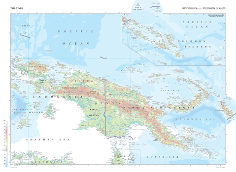
The Times Map of New Guinea and Solomon Islands
This map of New Guinea and the Solomon Islands is a benchmark of cartographic excellence, taken from the industry leading Times Comprehensive Atlas of the World. The second-largest island in the world, this map shows the two halves of the island: the Western region of Papua New Guinea and the Eastern region forming part of Indonesia. The capitals of both regions: Port Moresby and Jayapura, are easily identifiable, as are extra features including mountain ranges and additional islands. The Solomon Islands are also shown in detail, with the added sea level and water depth markers making it easy to understand the data being presented. Carefully curated to ensure coherence and attractiveness, each element of this map has been thoughtfully selected to provide a clear and engaging visual guide to New Guinea and the Solomon Islands.
Page Size: 36.5 x 26.75 in (924 x 675 mm)
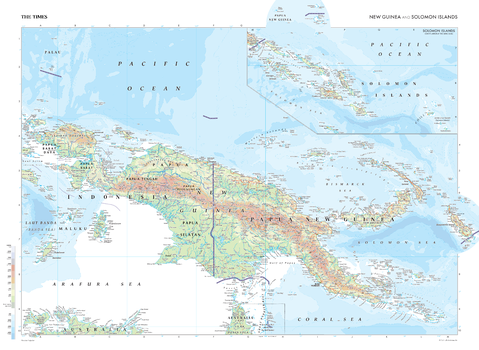
The Times Map of New Guinea and Solomon Islands - Compact
This map of New Guinea and the Solomon Islands is a benchmark of cartographic excellence, taken from the industry leading Times Comprehensive Atlas of the World. The second-largest island in the world, this map shows the two halves of the island: the Western region of Papua New Guinea and the Eastern region forming part of Indonesia. The capitals of both regions: Port Moresby and Jayapura, are easily identifiable, as are extra features including mountain ranges and additional islands. The Solomon Islands are also shown in detail, with the added sea level and water depth markers making it easy to understand the data being presented. Carefully curated to ensure coherence and attractiveness, each element of this map has been thoughtfully selected to provide a clear and engaging visual guide to New Guinea and the Solomon Islands.
Page Size: 22.25 x 16.25 in (561 x 410 mm)
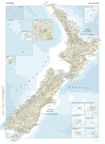
The Times Map of New Zealand
This map of New Zealand is a benchmark of cartographic excellence, taken from the industry leading Times Comprehensive Atlas of the World. Showing both the North Island (Te Ika-a-Māui) and South Island (Te Waipounamu), with a further eleven inset maps showing the following surrounding islands and island groups: Snares Islands/ Tini Heke, Chatham Islands, Auckland Islands, Bounty Islands, Campbell Island/ Motu Ihupuku, Antipodes Islands, Cook Islands, Rarotonga, Kermadec Islands, Tokelau, and Niue. An additional inset map provides a road map of Auckland. Each element is carefully chosen to make the map a coherent and attractive visual guide to New Zealand.
Page Size: 26.75 x 36.5 in (675 x 924 mm)
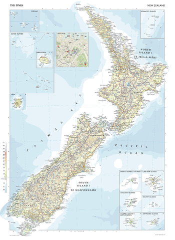
The Times Map of New Zealand - Compact
This map of New Zealand is a benchmark of cartographic excellence, taken from the industry leading Times Comprehensive Atlas of the World. Showing both the North Island (Te Ika-a-Māui) and South Island (Te Waipounamu), with a further eleven inset maps showing the following surrounding islands and island groups: Snares Islands/ Tini Heke, Chatham Islands, Auckland Islands, Bounty Islands, Campbell Island/ Motu Ihupuku, Antipodes Islands, Cook Islands, Rarotonga, Kermadec Islands, Tokelau, and Niue. An additional inset map provides a road map of Auckland. Each element is carefully chosen to make the map a coherent and attractive visual guide to New Zealand.
Page Size: 16.25 x 22.25 in (410 x 561 mm)
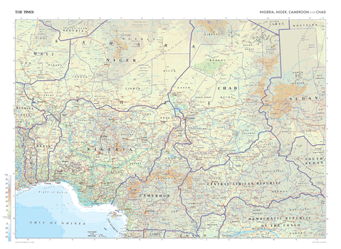
The Times Map of Nigeria, Niger, Cameroon and Chad
This map of Nigeria, Niger, Cameroon, and Chad stands as a benchmark of cartographic excellence, sourced from the industry-leading Times Comprehensive Atlas of the World. Published in full colour, this map offers a comprehensive and updated view of the landscapes that are found in this region. Prominent features such as the bustling cities of Lagos, Niamey, and N'Djamena are clearly identifiable, as are geographical features such as the Sahara Desert and Lake Chad. Additional mapping covers countries such as the Central African Republic, Mali, Benin, and Tongo. With meticulous attention to detail, this map is an indispensable guide to the geographic intricacies of Nigeria, Niger, Cameroon, and Chad.
Page Size: 36.5 x 26.75 in (924 x 675 mm)
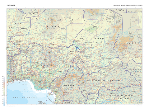
The Times Map of Nigeria, Niger, Cameroon and Chad - Compact
This map of Nigeria, Niger, Cameroon, and Chad stands as a benchmark of cartographic excellence, sourced from the industry-leading Times Comprehensive Atlas of the World. Published in full colour, this map offers a comprehensive and updated view of the landscapes that are found in this region. Prominent features such as the bustling cities of Lagos, Niamey, and N'Djamena are clearly identifiable, as are geographical features such as the Sahara Desert and Lake Chad. Additional mapping covers countries such as the Central African Republic, Mali, Benin, and Tongo. With meticulous attention to detail, this map is an indispensable guide to the geographic intricacies of Nigeria, Niger, Cameroon, and Chad.
Page Size: 22.25 x 16.25 in (561 x 410 mm)
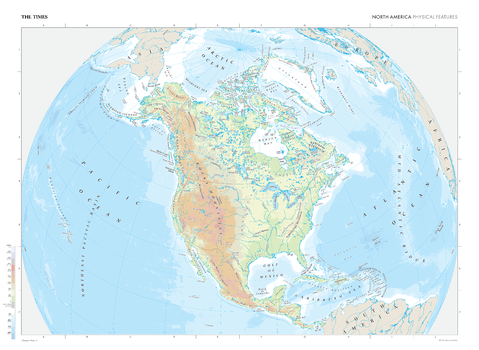
The Times Map of North America (Physical Features)
This map of North America's physical features stands as a benchmark of cartographic excellence, sourced from the industry-leading Times Comprehensive Atlas of the World. Published in full colour, this map offers a comprehensive and updated view of the diverse landscapes and geographical attributes that characterise the North American continent. Encompassing geographical features such as the Rocky Mountain range, the Great Plains, the Great Lakes, and the Mississippi River, this map provides a clear representation of North America's natural features. With meticulous attention to detail, this map is an indispensable guide to the geographic intricacies and highlights of North America's physical characteristics.
Page Size: 36.5 x 26.75 in (924 x 675 mm)

The Times Map of North America (Physical Features) - Compact
This map of North America's physical features stands as a benchmark of cartographic excellence, sourced from the industry-leading Times Comprehensive Atlas of the World. Published in full colour, this map offers a comprehensive and updated view of the diverse landscapes and geographical attributes that characterise the North American continent. Encompassing geographical features such as the Rocky Mountain range, the Great Plains, the Great Lakes, and the Mississippi River, this map provides a clear representation of North America's natural features. With meticulous attention to detail, this map is an indispensable guide to the geographic intricacies and highlights of North America's physical characteristics.
Page Size: 22.25 x 16.25 in (561 x 410 mm)
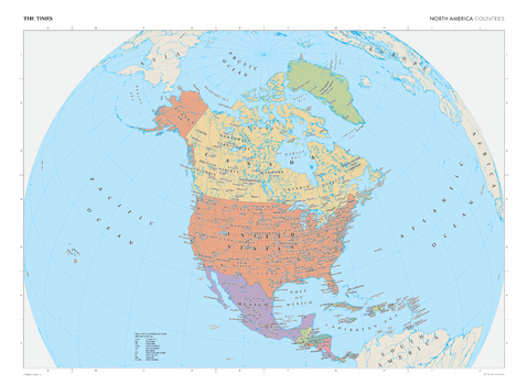
The Times Map of North America (Political Features)
This map of North America's political boundaries stands as a benchmark of cartographic excellence, sourced from the industry-leading Times Comprehensive Atlas of the World. Published in full colour, this map offers a comprehensive and updated view of the international, provincial and territorial boundaries, capitals cities and main urban areas that characterise the North American continent. With meticulous attention to detail, this map is an indispensable guide to the geographic intricacies and highlights of North America's political composition.
Page Size: 36.5 x 26.75 in (924 x 675 mm)
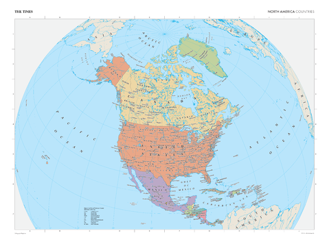
The Times Map of North America (Political Features) - Compact
This map of North America's political boundaries stands as a benchmark of cartographic excellence, sourced from the industry-leading Times Comprehensive Atlas of the World. Published in full colour, this map offers a comprehensive and updated view of the international, provincial and territorial boundaries, capitals cities and main urban areas that characterise the North American continent. With meticulous attention to detail, this map is an indispensable guide to the geographic intricacies and highlights of North America's political composition.
Page Size: 22.25 x 16.25 in (561 x 410 mm)
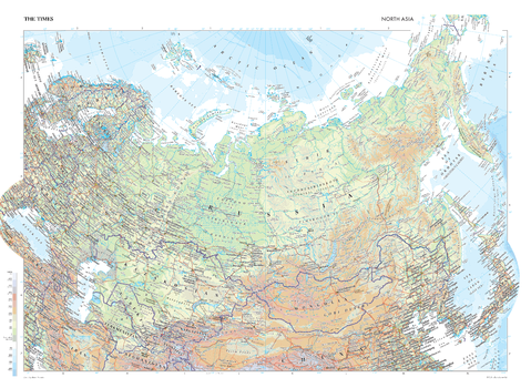
The Times Map of North Asia
This map of North Asia stands as a benchmark of cartographic excellence, sourced from the industry-leading Times Comprehensive Atlas of the World. Published in full colour, this map offers a comprehensive and updated view of the diverse landscapes that appear across this expansive region. Prominent features such as the Caspian Sea and the Gobi Desert, and key cities such as Moscow and Beijing are clearly identifiable. With meticulous attention to detail, this map is an indispensable guide to the geographic intricacies of North Asia.
Page Size: 36.5 x 26.75 in (924 x 675 mm)

The Times Map of North Asia - Compact
This map of North Asia stands as a benchmark of cartographic excellence, sourced from the industry-leading Times Comprehensive Atlas of the World. Published in full colour, this map offers a comprehensive and updated view of the diverse landscapes that appear across this expansive region. Prominent features such as the Caspian Sea and the Gobi Desert, and key cities such as Moscow and Beijing are clearly identifiable. With meticulous attention to detail, this map is an indispensable guide to the geographic intricacies of North Asia.
Page Size: 22.25 x 16.25 in (561 x 410 mm)
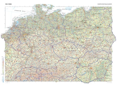
The Times Map of North Central Europe
This map of North Central Europe stands as a benchmark of cartographic excellence, sourced from the industry-leading Times Comprehensive Atlas of the World. Published in full colour, this map offers a comprehensive and updated view of the numerous countries in this region, including: Germany, the Netherlands, Switzerland, Slovakia, Hungary, Belgium, and many more. Prominent features such as the historic cities of Berlin, Prague, and Warsaw, the mountain peaks in the Alps, and key landmarks are clearly identifiable. With meticulous attention to detail, this map is an indispensable guide to the geographic intricacies of North Central Europe.
Page Size: 36.5 x 26.75 in (924 x 675 mm)
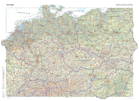
The Times Map of North Central Europe - Compact
This map of North Central Europe stands as a benchmark of cartographic excellence, sourced from the industry-leading Times Comprehensive Atlas of the World. Published in full colour, this map offers a comprehensive and updated view of the numerous countries in this region, including: Germany, the Netherlands, Switzerland, Slovakia, Hungary, Belgium, and many more. Prominent features such as the historic cities of Berlin, Prague, and Warsaw, the mountain peaks in the Alps, and key landmarks are clearly identifiable. With meticulous attention to detail, this map is an indispensable guide to the geographic intricacies of North Central Europe.
Page Size: 22.25 x 16.25 in (561 x 410 mm)