The Times
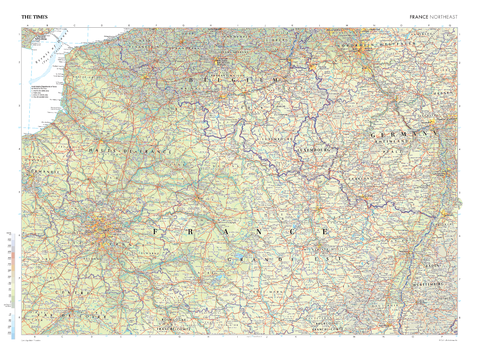
The Times Map of France (Northeast) - Compact
This map of France's Northeast region stands as a benchmark of cartographic excellence, sourced from the industry-leading Times Comprehensive Atlas of the World. Published in full colour, this map offers a comprehensive and updated view of this area, with additional mapping of Belgium, Luxembourg and Germany. International and administrative boundaries are clearly identifiable, as are prominent cities such as Paris, Strasbourg and Lille. With meticulous attention to detail, this map is an indispensable guide to the geographic intricacies of France's Northeast.
Page Size: 22.25 x 16.25 in (561 x 410 mm)
The Times Map of France (Northwest)
This map of France's Northwest region stands as a benchmark of cartographic excellence, sourced from the industry-leading Times Comprehensive Atlas of the World. Published in full colour, this map offers a comprehensive and updated view of the northwest coast of France, including the English Channel (La Manche) and the Channel Islands. Prominent cities such as Nantes, Tours, Rouen, and France's capital, Paris, are clearly identifiable. Notably, the map includes an additional inset street map of Paris, adding an extra layer of detail to this iconic capital city. With meticulous attention to detail, this map is an indispensable guide to the geographic intricacies of France's Northwest.
Page Size: 36.5 x 26.75 in (924 x 675 mm)

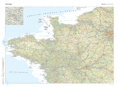
The Times Map of France (Northwest) - Compact
This map of France's Northwest region stands as a benchmark of cartographic excellence, sourced from the industry-leading Times Comprehensive Atlas of the World. Published in full colour, this map offers a comprehensive and updated view of the northwest coast of France, including the English Channel (La Manche) and the Channel Islands. Prominent cities such as Nantes, Tours, Rouen, and France's capital, Paris, are clearly identifiable. Notably, the map includes an additional inset street map of Paris, adding an extra layer of detail to this iconic capital city. With meticulous attention to detail, this map is an indispensable guide to the geographic intricacies of France's Northwest.
Page Size: 22.25 x 16.25 in (561 x 410 mm)
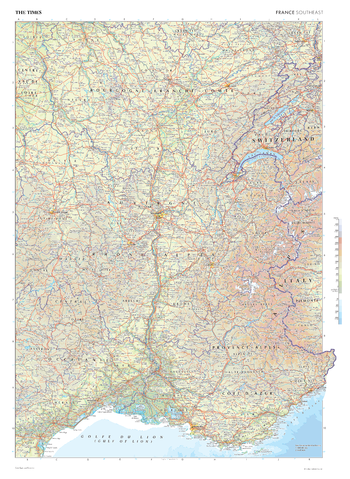
The Times Map of France (Southeast)
This map of France's Southeast region stands as a benchmark of cartographic excellence, sourced from the industry-leading Times Comprehensive Atlas of the World. Published in full colour, this map offers a comprehensive and updated view of the landscapes found this region. Prominent features such as the southern coastline, the alps, and key cities such as Lyon, Marseille and Nice are clearly identifiable. With meticulous attention to detail, this map is an indispensable guide to the geographic intricacies of France's Southeast.
Page Size: 26.75 x 36.5 in (675 x 924 mm)
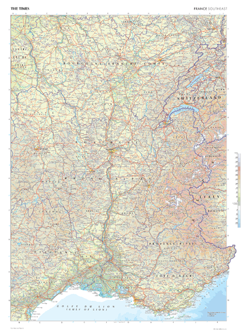
The Times Map of France (Southeast) - Compact
This map of France's Southeast region stands as a benchmark of cartographic excellence, sourced from the industry-leading Times Comprehensive Atlas of the World. Published in full colour, this map offers a comprehensive and updated view of the landscapes found this region. Prominent features such as the southern coastline, the alps, and key cities such as Lyon, Marseille and Nice are clearly identifiable. With meticulous attention to detail, this map is an indispensable guide to the geographic intricacies of France's Southeast.
Page Size: 16.25 x 22.25 in (410 x 561 mm)
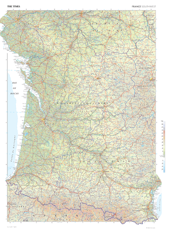
The Times Map of France (Southwest)
This map of France's Southwest region stands as a benchmark of cartographic excellence, sourced from the industry-leading Times Comprehensive Atlas of the World. Published in full colour, this map offers a comprehensive and updated view of the varied landscapes that are found in this region. Prominent features such as the historic cities of Bordeaux, Toulouse, and the Pyrenees mountain range on the Spanish border are clearly identifiable. With meticulous attention to detail, this map is an indispensable guide to the geographic intricacies of France's Southwest.
Page Size: 26.75 x 36.5 in (675 x 924 mm)
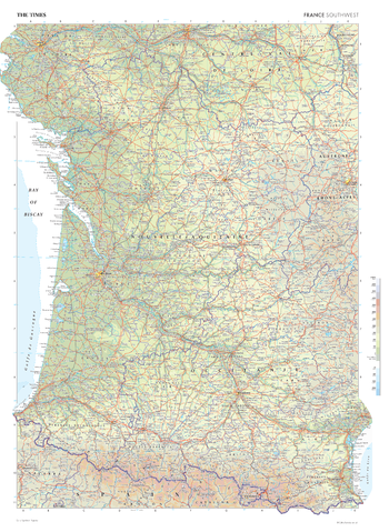
The Times Map of France (Southwest) - Compact
This map of France's Southwest region stands as a benchmark of cartographic excellence, sourced from the industry-leading Times Comprehensive Atlas of the World. Published in full colour, this map offers a comprehensive and updated view of the varied landscapes that are found in this region. Prominent features such as the historic cities of Bordeaux, Toulouse, and the Pyrenees mountain range on the Spanish border are clearly identifiable. With meticulous attention to detail, this map is an indispensable guide to the geographic intricacies of France's Southwest.
Page Size: 16.25 x 22.25 in (410 x 561 mm)
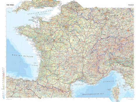
The Times Map of France - Compact
This map of France is a benchmark of cartographic excellence, taken from the industry leading Times Comprehensive Atlas of the World. There is a high level of detail packed into the map, yet the positioning of every element is carefully chosen to make the map coherent and attractive. Major cities including Lyon and Marseille are easily identifiable, as is the capital, Paris. International borders are clearly marked as are regional boundaries within France. Supplementary mapping covers Switzerland, northern Italy, Spain, western Germany and southern England. The island region of Corse (Corsica) is also fully visible. Geographical features such as the Alps and the Pyrenees Mountain range are also marked.
Page Size: 22.25 x 16.25 in (561 x 410 mm)
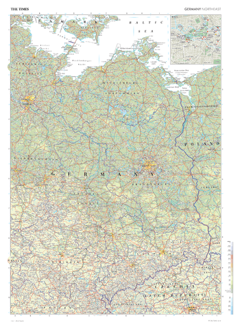
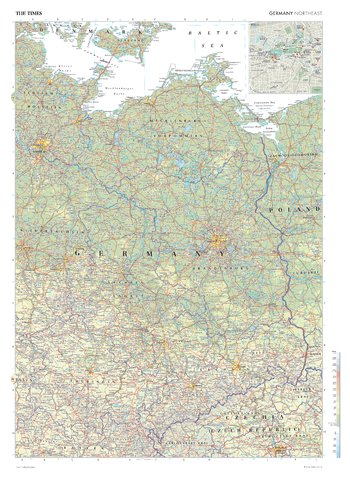
The Times Map of Germany (Northeast)
This map of Germany's Northeast region stands as a benchmark of cartographic excellence, sourced from the industry-leading Times Comprehensive Atlas of the World. Published in full colour, this map offers a comprehensive and updated view of the landscapes that are found in this area. Prominent features such as Germany's capital, Berlin, and key landmarks are clearly identifiable. Notably, the map includes an inset street map of Berlin, adding an extra layer of detail to this vibrant capital city. With meticulous attention to detail, this map is an indispensable guide to the geographic intricacies of Germany's north-eastern regions.
Page Size: 26.75 x 36.5 in (675 x 924 mm)
The Times Map of Germany (Northeast) - Compact
This map of Germany's Northeast region stands as a benchmark of cartographic excellence, sourced from the industry-leading Times Comprehensive Atlas of the World. Published in full colour, this map offers a comprehensive and updated view of the landscapes that are found in this area. Prominent features such as Germany's capital, Berlin, and key landmarks are clearly identifiable. Notably, the map includes an inset street map of Berlin, adding an extra layer of detail to this vibrant capital city. With meticulous attention to detail, this map is an indispensable guide to the geographic intricacies of Germany's north-eastern regions.
Page Size: 16.25 x 22.25 in (410 x 561 mm)
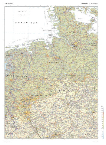
The Times Map of Germany (Northwest)
This map of north west Germany stands as a benchmark of cartographic excellence, sourced from the industry-leading Times Comprehensive Atlas of the World. Published in full colour, this map offers a comprehensive and updated view of Germany's north-western regions, with additional mapping covering the Netherlands and north Belgium. Prominent features such as the cities of Hamburg, Hannover, and Dusseldorf are clearly identifiable. With meticulous attention to detail, this map is an indispensable guide to the geographic intricacies of Germany's north-western regions.
Page Size: 26.75 x 36.5 in (675 x 924 mm)
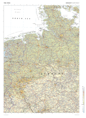
The Times Map of Germany (Northwest) - Compact
This map of north west Germany stands as a benchmark of cartographic excellence, sourced from the industry-leading Times Comprehensive Atlas of the World. Published in full colour, this map offers a comprehensive and updated view of Germany's north-western regions, with additional mapping covering the Netherlands and north Belgium. Prominent features such as the cities of Hamburg, Hannover, and Dusseldorf are clearly identifiable. With meticulous attention to detail, this map is an indispensable guide to the geographic intricacies of Germany's north-western regions.
Page Size: 16.25 x 22.25 in (410 x 561 mm)
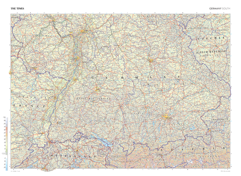
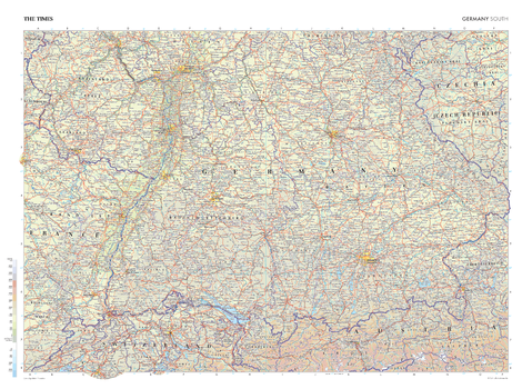
The Times Map of Germany (South)
This map of Germany's southern regions stands as a benchmark of cartographic excellence, sourced from the industry-leading Times Comprehensive Atlas of the World. Published in full colour, this map offers a comprehensive and updated view of the landscapes that make up this area. Prominent features such as the winding Rhine River, the historic cities of Munich and Stuttgart, and key landmarks are clearly identifiable. With meticulous attention to detail, this map is an indispensable guide to the geographic intricacies of southern Germany.
Page Size: 36.5 x 26.75 in (924 x 675 mm)
The Times Map of Germany (South) - Compact
This map of Germany's southern regions stands as a benchmark of cartographic excellence, sourced from the industry-leading Times Comprehensive Atlas of the World. Published in full colour, this map offers a comprehensive and updated view of the landscapes that make up this area. Prominent features such as the winding Rhine River, the historic cities of Munich and Stuttgart, and key landmarks are clearly identifiable. With meticulous attention to detail, this map is an indispensable guide to the geographic intricacies of southern Germany.
Page Size: 22.25 x 16.25 in (561 x 410 mm)

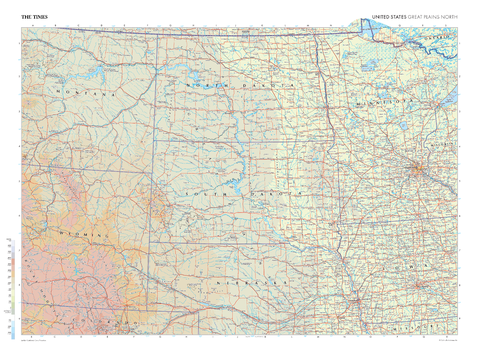
The Times Map of Great Plains North (United States)
This map of the US Great Plains (north) stands as a benchmark of cartographic excellence, sourced from the industry-leading Times Comprehensive Atlas of the World. Published in full colour, this map offers a comprehensive and updated view of the diverse landscapes that are found in this region. Encompassing states such as North Dakota, South Dakota, Nebraska, Wyoming and Minnesota, this map includes prominent features including: the vast prairie landscapes, the marshlands in the north east, and the city of Minneapolis. With meticulous attention to detail, this map is an indispensable guide to the geographic intricacies of the US Great Plains North.
Page Size: 36.5 x 26.75 in (924 x 675 mm)
The Times Map of Great Plains North (United States) - Compact
This map of the US Great Plains (north) stands as a benchmark of cartographic excellence, sourced from the industry-leading Times Comprehensive Atlas of the World. Published in full colour, this map offers a comprehensive and updated view of the diverse landscapes that are found in this region. Encompassing states such as North Dakota, South Dakota, Nebraska, Wyoming and Minnesota, this map includes prominent features including: the vast prairie landscapes, the marshlands in the north east, and the city of Minneapolis. With meticulous attention to detail, this map is an indispensable guide to the geographic intricacies of the US Great Plains North.
Page Size: 22.25 x 16.25 in (561 x 410 mm)
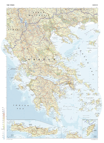
The Times Map of Greece
This map of Greece is a benchmark of cartographic excellence, taken from the industry leading Times Comprehensive Atlas of the World. There is a high level of detail packed into the map, yet the positioning of every element is carefully chosen to make the map coherent and attractive. Major cities such as Thessaloniki are easily identifiable, as is the capital, Athina (Athens). International borders are clearly marked as are regional boundaries within Greece, and geographical features, such as the Peloponnesian mountains. Additional inset maps provide detailed views of the islands of Crete and Rhodes. Each element is carefully chosen to make the map a coherent and attractive visual guide to Greece.
Page Size: 26.75 x 36.5 in (675 x 924 mm)
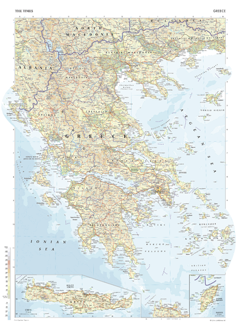
The Times Map of Greece - Compact
This map of Greece is a benchmark of cartographic excellence, taken from the industry leading Times Comprehensive Atlas of the World. There is a high level of detail packed into the map, yet the positioning of every element is carefully chosen to make the map coherent and attractive. Major cities such as Thessaloniki are easily identifiable, as is the capital, Athina (Athens). International borders are clearly marked as are regional boundaries within Greece, and geographical features, such as the Peloponnesian mountains. Additional inset maps provide detailed views of the islands of Crete and Rhodes. Each element is carefully chosen to make the map a coherent and attractive visual guide to Greece.
Page Size: 16.25 x 22.25 in (410 x 561 mm)
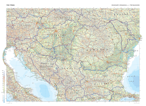
The Times Map of Hungary, Romania and The Balkans
This map of Hungary, Romania, and the Balkans stands as a benchmark of cartographic excellence, sourced from the industry-leading Times Comprehensive Atlas of the World. Published in full colour, this map offers a comprehensive and updated view of the landscapes that are found in this region. Countries covered in this map include: Hungary, Romania, Austria, Croatia, Slovenia, Serbia, Bulgaria, Moldovia, and Slovakia, amongst others. This map clearly displays major cities and urban areas including: Budapest, Bucharest, Vienna, Sofia, and Belgrade, as well as other key landmarks across the Balkans. With meticulous attention to detail, this map is an indispensable guide to the geographic intricacies of Hungary, Romania, and the Balkans.
Page Size: 36.5 x 26.75 in (924 x 675 mm)
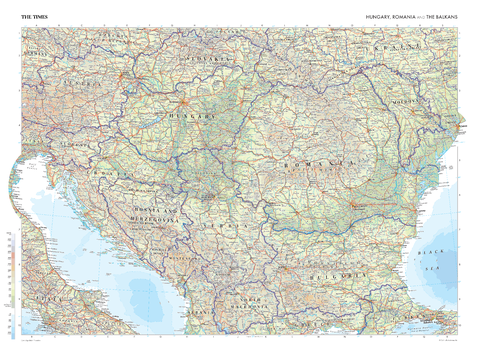
The Times Map of Hungary, Romania and The Balkans - Compact
This map of Hungary, Romania, and the Balkans stands as a benchmark of cartographic excellence, sourced from the industry-leading Times Comprehensive Atlas of the World. Published in full colour, this map offers a comprehensive and updated view of the landscapes that are found in this region. Countries covered in this map include: Hungary, Romania, Austria, Croatia, Slovenia, Serbia, Bulgaria, Moldovia, and Slovakia, amongst others. This map clearly displays major cities and urban areas including: Budapest, Bucharest, Vienna, Sofia, and Belgrade, as well as other key landmarks across the Balkans. With meticulous attention to detail, this map is an indispensable guide to the geographic intricacies of Hungary, Romania, and the Balkans.
Page Size: 22.25 x 16.25 in (561 x 410 mm)