The Times

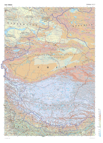
The Times Map of China (West)
This map of China's West region stands as a benchmark of cartographic excellence, sourced from the industry-leading Times Comprehensive Atlas of the World. Published in full colour, this map offers a comprehensive and updated view of the diverse landscapes that define this area. Prominent features such as the vast mountainous region of Xizang Zizhiqu (Tibet) and the Himalayas are clearly identifiable, as are major lakes, rivers and urban centres. Additional mapping covers the north of India, Nepal, Bhutan, eastern Mongolia and western Kazakhstan. With meticulous attention to detail, this map is an indispensable guide to the geographic and regional intricacies of China's western regions.
Page Size: 26.75 x 36.5 in (675 x 924 mm)
The Times Map of China (West) - Compact
This map of China's West region stands as a benchmark of cartographic excellence, sourced from the industry-leading Times Comprehensive Atlas of the World. Published in full colour, this map offers a comprehensive and updated view of the diverse landscapes that define this area. Prominent features such as the vast mountainous region of Xizang Zizhiqu (Tibet) and the Himalayas are clearly identifiable, as are major lakes, rivers and urban centres. Additional mapping covers the north of India, Nepal, Bhutan, eastern Mongolia and western Kazakhstan. With meticulous attention to detail, this map is an indispensable guide to the geographic and regional intricacies of China's western regions.
Page Size: 16.25 x 22.5 in (410 x 568 mm)
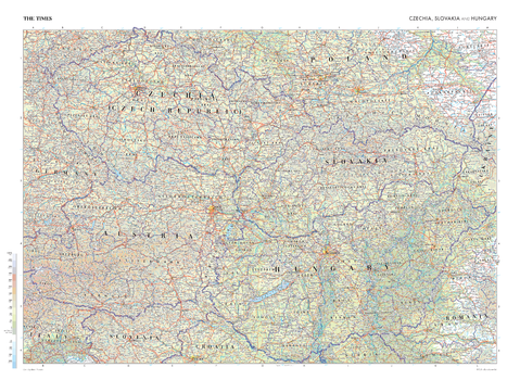
The Times Map of Czech Republic, Slovakia and Hungary
This map of the Czech Republic, Slovakia, and Hungary stands as a benchmark of cartographic excellence, sourced from the industry-leading Times Comprehensive Atlas of the World. Published in full colour, this map offers a comprehensive and updated view of the landscape that makes up this region. Prominent features such as the historic cities of Prague, Budapest, and Bratislava, the scenic landscapes, and key landmarks are clearly identifiable. Additional mapping also covers parts of Romania, Slovenia, Croatia, Italy, Germany and Poland. With meticulous attention to detail, this map is an indispensable guide to the geographic intricacies of the Czech Republic, Slovakia, and Hungary.
Page Size: 36.5 x 26.75 in (924 x 675 mm)
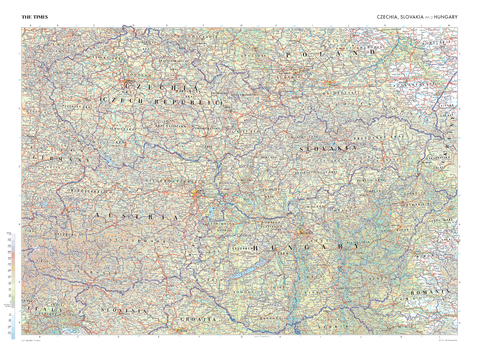
The Times Map of Czech Republic, Slovakia and Hungary - Compact
This map of the Czech Republic, Slovakia, and Hungary stands as a benchmark of cartographic excellence, sourced from the industry-leading Times Comprehensive Atlas of the World. Published in full colour, this map offers a comprehensive and updated view of the landscape that makes up this region. Prominent features such as the historic cities of Prague, Budapest, and Bratislava, the scenic landscapes, and key landmarks are clearly identifiable. Additional mapping also covers parts of Romania, Slovenia, Croatia, Italy, Germany and Poland. With meticulous attention to detail, this map is an indispensable guide to the geographic intricacies of the Czech Republic, Slovakia, and Hungary.
Page Size: 22.25 x 16.25 in (561 x 410 mm)
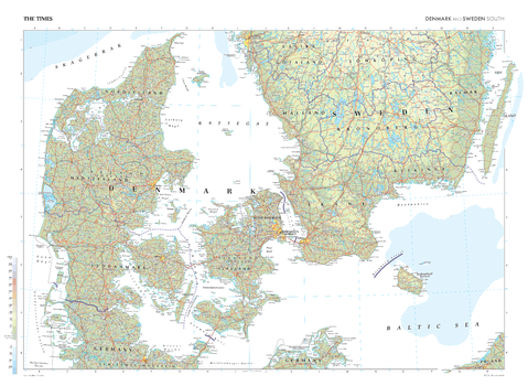
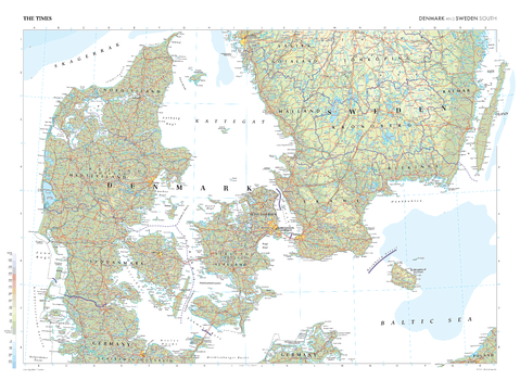
The Times Map of Denmark and Sweden (South)
This map of Denmark and Sweden's southern regions stands as a benchmark of cartographic excellence, sourced from the industry-leading Times Comprehensive Atlas of the World. Published in full colour, this map offers a comprehensive and updated view of the landscapes that make up this region. Prominent features such as the distinct Danish islands, the Baltic Sea, and key cities such as Copenhagen and Malmö, are clearly identifiable. With meticulous attention to detail, this map is an indispensable guide to the geography of Denmark and Sweden's southern regions.
Page Size: 36.5 x 26.75 in (924 x 675 mm)
The Times Map of Denmark and Sweden (South) - Compact
This map of Denmark and Sweden's southern regions stands as a benchmark of cartographic excellence, sourced from the industry-leading Times Comprehensive Atlas of the World. Published in full colour, this map offers a comprehensive and updated view of the landscapes that make up this region. Prominent features such as the distinct Danish islands, the Baltic Sea, and key cities such as Copenhagen and Malmö, are clearly identifiable. With meticulous attention to detail, this map is an indispensable guide to the geography of Denmark and Sweden's southern regions.
Page Size: 22.25 x 16.25 in (561 x 410 mm)
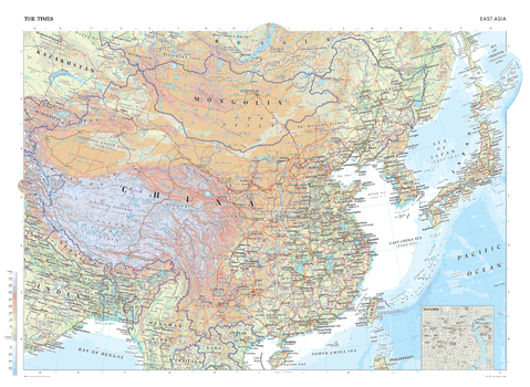
The Times Map of East Asia
This map of East Asia is a benchmark of cartographic excellence, taken from the industry leading Times Comprehensive Atlas of the World. Covering: Bangladesh, China, India, Japan, Kazakhstan, Kyrgyzstan, Laos, Mongolia, Myanmar, North and South Korea, Nepal, Taiwan, and Vietnam, this is an inclusive and encompassing representation of East Asia. Capital and major cities are clearly marked, as are geographical features such as the Himalaya Mountain Range. An additional inset map provides a road map of Shanghai. Each element is carefully chosen to make the map a coherent and attractive visual guide to East Asia.
Page Size: 36.5 x 26.75 in (924 x 675 mm)

The Times Map of East Asia - Compact
This map of East Asia is a benchmark of cartographic excellence, taken from the industry leading Times Comprehensive Atlas of the World. Covering: Bangladesh, China, India, Japan, Kazakhstan, Kyrgyzstan, Laos, Mongolia, Myanmar, North and South Korea, Nepal, Taiwan, and Vietnam, this is an inclusive and encompassing representation of East Asia. Capital and major cities are clearly marked, as are geographical features such as the Himalaya Mountain Range. An additional inset map provides a road map of Shanghai. Each element is carefully chosen to make the map a coherent and attractive visual guide to East Asia.
Page Size: 22.25 x 16.25 in (561 x 410 mm)

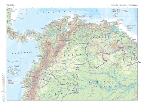
The Times Map of Ecuador, Colombia and Venezuela
This map of Ecuador, Colombia, and Venezuela stands as a benchmark of cartographic excellence, sourced from the industry-leading Times Comprehensive Atlas of the World. Published in full colour, this map offers a comprehensive and updated view of the diverse landscapes and attractions that define this region. Encompassing countries such as Ecuador, Colombia, and Venezuela, this map includes prominent features such as the Andes mountain range, the Amazon river, and the cities of Quito, Bogota and Caracas. This map also includes a scale inset of the Galapagos Islands, adding an extra layer of detail to this unique archipelago. With meticulous attention to detail, this map is an indispensable guide to the geographic intricacies of Ecuador, Colombia, and Venezuela.
Page Size: 36.5 x 26.75 in (924 x 675 mm)
The Times Map of Ecuador, Colombia and Venezuela - Compact
This map of Ecuador, Colombia, and Venezuela stands as a benchmark of cartographic excellence, sourced from the industry-leading Times Comprehensive Atlas of the World. Published in full colour, this map offers a comprehensive and updated view of the diverse landscapes and attractions that define this region. Encompassing countries such as Ecuador, Colombia, and Venezuela, this map includes prominent features such as the Andes mountain range, the Amazon river, and the cities of Quito, Bogota and Caracas. This map also includes a scale inset of the Galapagos Islands, adding an extra layer of detail to this unique archipelago. With meticulous attention to detail, this map is an indispensable guide to the geographic intricacies of Ecuador, Colombia, and Venezuela.
Page Size: 22.25 x 16.25 in (561 x 410 mm)
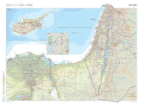
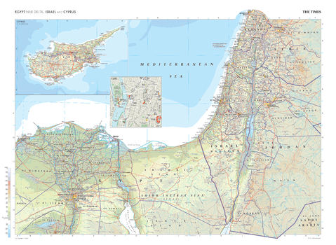
The Times Map of Egypt (Nile Delta), Israel and Cyprus
This map of Egypt (Nile Delta), Israel, and Cyprus stands as a benchmark of cartographic excellence, sourced from the industry-leading Times Comprehensive Atlas of the World. Published in full colour, this map offers a comprehensive and updated view of the geographical and political landscape of this region. Prominent features such as the Dead Sea, the Suez Canal and the River Nile are clearly identifiable. Additional inset maps provide detailed views of the island of Cyprus and a street plan of Egypt's capital city: Cairo. With meticulous attention to detail, this map is an indispensable guide to the geographic intricacies of Egypt (Nile Delta), Israel, and Cyprus.
Page Size: 36.5 x 26.75 in (924 x 675 mm)
The Times Map of Egypt (Nile Delta), Israel and Cyprus - Compact
This map of Egypt (Nile Delta), Israel, and Cyprus stands as a benchmark of cartographic excellence, sourced from the industry-leading Times Comprehensive Atlas of the World. Published in full colour, this map offers a comprehensive and updated view of the geographical and political landscape of this region. Prominent features such as the Dead Sea, the Suez Canal and the River Nile are clearly identifiable. Additional inset maps provide detailed views of the island of Cyprus and a street plan of Egypt's capital city: Cairo. With meticulous attention to detail, this map is an indispensable guide to the geographic intricacies of Egypt (Nile Delta), Israel, and Cyprus.
Page Size: 22.25 x 16.25 in (561 x 410 mm)
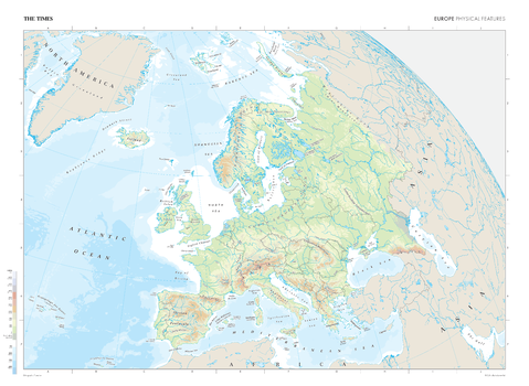
The Times Map of Europe (Physical Features)
This map of Europe's physical features stands as a benchmark of cartographic excellence, sourced from the industry-leading Times Comprehensive Atlas of the World. Published in full colour, this map offers a comprehensive and updated view of the diverse landscapes and geographical attributes that characterise the European continent. Encompassing the varied terrains, mountain ranges, rivers, lakes, and key landforms, this map provides a clear representation of Europe's natural features. With meticulous attention to detail, this map is an indispensable guide to the geographic intricacies and highlights of Europe's physical characteristics.
Page Size: 36.5 x 26.75 in (924 x 675 mm)
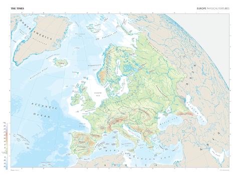
The Times Map of Europe (Physical Features) - Compact
This map of Europe's physical features stands as a benchmark of cartographic excellence, sourced from the industry-leading Times Comprehensive Atlas of the World. Published in full colour, this map offers a comprehensive and updated view of the diverse landscapes and geographical attributes that characterise the European continent. Encompassing the varied terrains, mountain ranges, rivers, lakes, and key landforms, this map provides a clear representation of Europe's natural features. With meticulous attention to detail, this map is an indispensable guide to the geographic intricacies and highlights of Europe's physical characteristics.
Page Size: 22.25 x 16.25 in (561 x 410 mm)
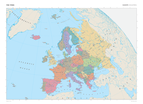
The Times Map of Europe (Political Features)
This map of Europe's political boundaries stands as a benchmark of cartographic excellence, sourced from the industry-leading Times Comprehensive Atlas of the World. Published in full colour, this map offers a comprehensive and updated view of the diverse countries, capitals, cities, and regions that characterise the European continent. Detailing the national borders, capital cities, and key urban centres, this map provides a clear representation of Europe's political landscape. With meticulous attention to detail, this map is an indispensable guide to the geographic intricacies and highlights of Europe's political landscape.
Page Size: 36.5 x 26.75 in (924 x 675 mm)

The Times Map of Europe (Political Features) - Compact
This map of Europe's political boundaries stands as a benchmark of cartographic excellence, sourced from the industry-leading Times Comprehensive Atlas of the World. Published in full colour, this map offers a comprehensive and updated view of the diverse countries, capitals, cities, and regions that characterise the European continent. Detailing the national borders, capital cities, and key urban centres, this map provides a clear representation of Europe's political landscape. With meticulous attention to detail, this map is an indispensable guide to the geographic intricacies and highlights of Europe's political landscape.
Page Size: 22.25 x 16.25 in (561 x 410 mm)
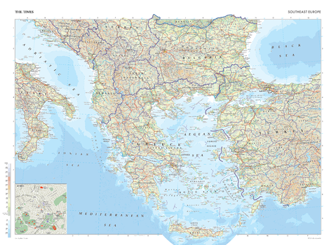
The Times Map of Europe (Southeast)
This map of Southeast Europe stands as a benchmark of cartographic excellence, sourced from the industry-leading Times Comprehensive Atlas of the World. Published in full colour, this map offers a comprehensive and updated view of the landscapes that are found in this region. Encompassing countries such as Greece, Bulgaria, Turkey, North Macedonia and more, this map includes prominent features such as the historic cities, the sprawling coastlines and key geographical features. With meticulous attention to detail, this map is an indispensable guide to the geographic intricacies of Southeast Europe.
Page Size: 36.5 x 26.75 in (924 x 675 mm)

The Times Map of Europe (Southeast) - Compact
This map of Southeast Europe stands as a benchmark of cartographic excellence, sourced from the industry-leading Times Comprehensive Atlas of the World. Published in full colour, this map offers a comprehensive and updated view of the landscapes that are found in this region. Encompassing countries such as Greece, Bulgaria, Turkey, North Macedonia and more, this map includes prominent features such as the historic cities, the sprawling coastlines and key geographical features. With meticulous attention to detail, this map is an indispensable guide to the geographic intricacies of Southeast Europe.
Page Size: 22.25 x 16.25 in (561 x 410 mm)
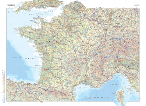
The Times Map of France
This map of France is a benchmark of cartographic excellence, taken from the industry leading Times Comprehensive Atlas of the World. There is a high level of detail packed into the map, yet the positioning of every element is carefully chosen to make the map coherent and attractive. Major cities including Lyon and Marseille are easily identifiable, as is the capital, Paris. International borders are clearly marked as are regional boundaries within France. Supplementary mapping covers Switzerland, northern Italy, Spain, western Germany and southern England. The island region of Corse (Corsica) is also fully visible. Geographical features such as the Alps and the Pyrenees Mountain range are also marked.
Page Size: 36.5 x 26.75 in (924 x 675 mm)
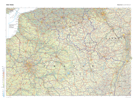
The Times Map of France (Northeast)
This map of France's Northeast region stands as a benchmark of cartographic excellence, sourced from the industry-leading Times Comprehensive Atlas of the World. Published in full colour, this map offers a comprehensive and updated view of this area, with additional mapping of Belgium, Luxembourg and Germany. International and administrative boundaries are clearly identifiable, as are prominent cities such as Paris, Strasbourg and Lille. With meticulous attention to detail, this map is an indispensable guide to the geographic intricacies of France's Northeast.
Page Size: 36.5 x 26.75 in (924 x 675 mm)