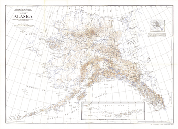
National Geographic
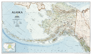
Alaska - Published 2002
One of the most beautiful maps of Alaska ever published, this map covers the entire breadth of this northern U.S. state, from the Inside Passage in the southeast, to Point Barrow in the North, and along the entire span of the Aleutian Islands. Artful cartography reveals national parks, mountain ranges, wildlife refuges, and preserves.
Page Size: 37.5 x 22.75 in (951 x 572 mm)
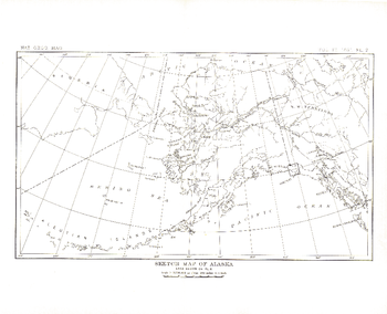
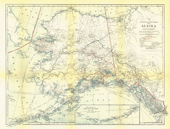
Alaska - Published 1891
This antique sketch map of Alaska was published in 1891 with the article "The Southern Coast of Alaska." One of several early maps of what would become the 49th state in Union, this work makes a fine companion for the Muir Glacier map of 1892.
Page Size: 12.25 x 10 in (307 x 249 mm)
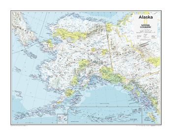
Alaska - Atlas of the World, 10th Edition
Page Size: 28 x 22 in (711 x 559 mm)
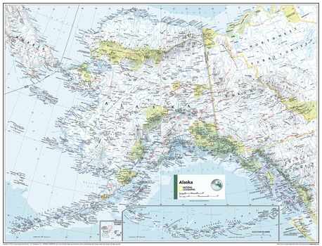
Alaska - Atlas of the World, 11th Edition
This Alaska map of physical and political features can fit in any space. Showcasing the region in stunning detail with state-of-the-art cartographic techniques delivering accuracy and exceptional quality, the innovative and engaging design makes the content easily accessible and user-friendly.
Ideal for classrooms with an emphasis on teaching geography or environmental themes. Physical maps give your students a genuine feel for how our world appears.
This map uses a bright, easy to read color palette featuring blue oceans and stunning shaded relief that has been featured on National Geographic wall maps for over 75 years. Drawn in the Azimuthal Equidistant projection, this map ensures that all points on the map are at proportionally correct distances from the center point.
This map is found in National Geographic's 11th Edition World Atlas and is now available as a stand alone product.
Page Size: 31.5 x 24 in (798 x 610 mm)

Alaska - Atlas of the World, 11th Edition - Compact
This Alaska map of physical and political features can fit in any space. Showcasing the region in stunning detail with state-of-the-art cartographic techniques delivering accuracy and exceptional quality, the innovative and engaging design makes the content easily accessible and user-friendly.
Ideal for classrooms with an emphasis on teaching geography or environmental themes. Physical maps give your students a genuine feel for how our world appears.
This map uses a bright, easy to read color palette featuring blue oceans and stunning shaded relief that has been featured on National Geographic wall maps for over 75 years. Drawn in the Azimuthal Equidistant projection, this map ensures that all points on the map are at proportionally correct distances from the center point.
This map is found in National Geographic's 11th Edition World Atlas and is now available as a stand alone product.
Page Size: 21.5 x 16.25 in (540 x 413 mm)
Alaska - Published 1904
This historic map of Alaska shows the region after the boundary was agreed to with Canada. Published in National Geographic Magazine in 1904 with the article "The Geography of Alaska," this map includes an inset showing areas mapped by the U.S. Geological Survey. A wonderful companion to the Alaska Boundary Tribunal map printed the same year.
Page Size: 49.5 x 36 in (1257 x 911 mm)
Alaska - Published 1914
Published in February 1914 with the article "The Nation's Undeveloped Resources," the Map of Alaska contains an abundance of details showing the growing human settlement of the region. U.S. public schools for natives, post offices, telegraph stations, mail routes, and mission stations are just some of the many features shown on this map.
Page Size: 21.5 x 16.5 in (545 x 416 mm)
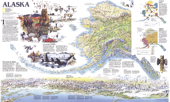
Alaska Theme - Published 1994
This attractive physical map of Alaska was published in May 1994 to accompany the political map of the state and the article "Alaska's Sky-High Wilderness." Besides its extraordinary geographical details, this map also contains information on federal lands, wildlife and the alaskan natives.
Page Size: 37 x 22.25 in (935 x 560 mm)
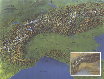
Alps, Europes Backbone - Published 1965
Published in 1965 with the article "The Alps: Man's Own Mountains," this map offers a detailed look at the countries occupying this particularly beautiful mountain region. A wonderful companion map to "The Alps, Europe's Backbone," a relief map printed in the same issue.
Page Size: 25 x 19 in (631 x 478 mm)
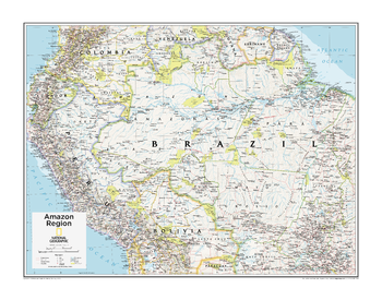
Amazon Region - Atlas of the World, 10th Edition
Brazil, Ecuador, French Guiana (France), Peru, Suriname
Page Size: 28 x 22 in (711 x 559 mm)
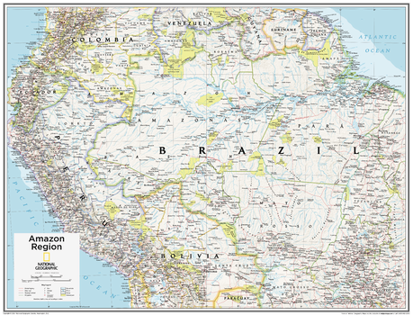
Amazon Region - Atlas of the World, 10th Edition - Compact
Brazil, Ecuador, French Guiana (France), Peru, Suriname
Page Size: 21 x 16 in (532 x 406 mm)
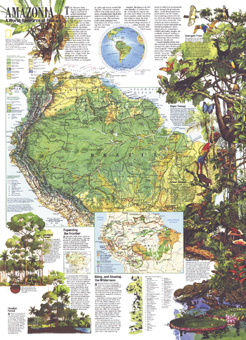
Amazonia, a World Resource At Risk - Published 1992
With a physical map of the Amazon basin as well as an abundance of illustrations and information about this magnificent region, this map is a must-have for those fascinated by the beauty and mystery of the tropical rainforest. Discover how this region's health affects the health of the entire planet and the threats facing it. Published in August 1992, it is a perfect companion for the political map of South America printed in the same issue.
Page Size: 20.25 x 28 in (512 x 707 mm)
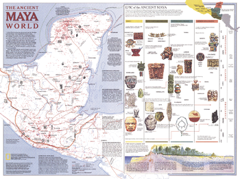
Ancient Maya World - Published 1989
Explore the fascinating world of the Maya with this map published in October 1989. This map accompanied the "Land of the Maya" map in the same issue and three articles on the Maya including "La Ruta Maya." This work features an abundance of information about trade, travel, and the landscape of their civilization, including an explanation of the various eras of Maya history.
Page Size: 27.25 x 20.25 in (687 x 512 mm)
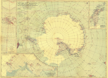
Antarctic Regions - Published 1932
This early map of the Antarctic regions was published in October 1932, just a few years after Byrd's historical flight over the South Pole. Parts of the inset maps were constructed using aerial photographs and the article "Mapping the Antarctic from the Air: The Aerial Camera Earns Its Place as the Eyes and Memory of the Explorer" appeared in the same issue of National Geographic.
Page Size: 26.25 x 19.25 in (664 x 484 mm)
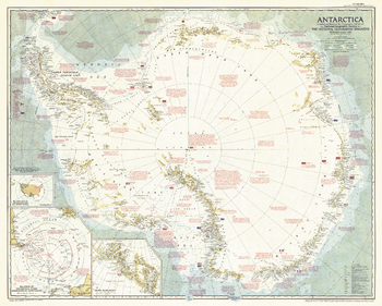
Antarctica - Published 1957
This striking map captures Antarctica at a pivotal time during its exploration. Contains a great amount of detail of both the geography and history of the multi–national expeditions that have traversed the icy continent. Published in 1957, just six months after the death of famed American polar explorer Admiral Richard E. Byrd, with the article "Year of Discovery Opens in Antarctica."
Page Size: 36.25 x 29 in (915 x 735 mm)
Antarctica - Published 1963
Explore the harsh, yet magnificent terrain of Antarctica in this finely detailed and educational map. Filled with information on the continent's geography as well as historical facts about its exploration. Published in February 1963 with the article "New Era in the Loneliest Continent."
Page Size: 25 x 19 in (631 x 479 mm)
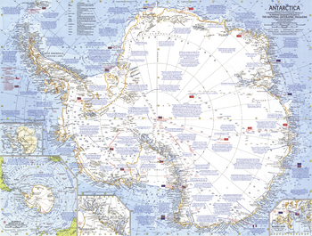
Antarctica - Published 1987
This map is loaded with information about Antarctica including expeditions, stations, wildlife, climate, and more. It also contains inset maps showing the entire subglacial continent and various countries claims on the region. Published in April 1987 as a companion to the "Pinnipeds Around the World" map and an article entitled "Seal and Their Kin".
Page Size: 30.25 x 21 in (763 x 531 mm)
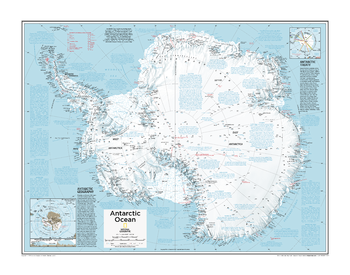
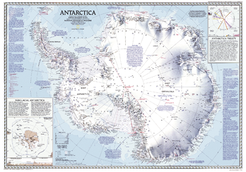
Antarctica Political - Atlas of the World, 10th Edition
Antarctic Geography, Antarctic Treaty
Page Size: 28 x 22 in (711 x 559 mm)
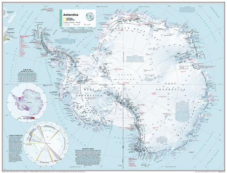
Antarctica Political - Atlas of the World, 11th Edition
This map of political features can fit in any space. Showcasing the Antarctic Ocean in stunning detail with state-of-the-art cartographic techniques delivering accuracy and exceptional quality, the innovative and engaging design makes the content easily accessible and user-friendly.
Ideal for classrooms with an emphasis on teaching geography or environmental themes. The inclusion of physical features on this map gives your students a genuine feel for how the African continent appears.
This political map of the Antarctic Ocean uses a bright, easy to read color palette featuring blue oceans and stunning shaded relief that has been featured on National Geographic wall maps for over 75 years.
Names of geographic features such as international boundaries, cities, rivers and lakes are carefully placed on the map to maintain legibility.
This map is found in National Geographic's 11th Edition World Atlas and is now available as a stand alone product.
Page Size: 31.5 x 24 in (798 x 610 mm)
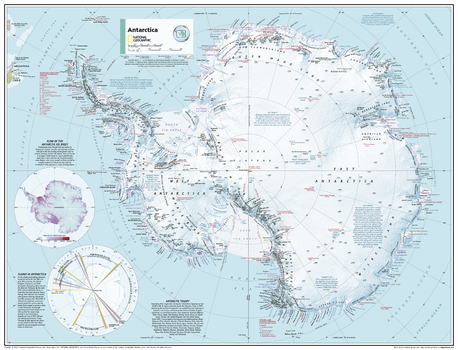
Antarctica Political - Atlas of the World, 11th Edition - Compact
This map of political features can fit in any space. Showcasing the Antarctic Ocean in stunning detail with state-of-the-art cartographic techniques delivering accuracy and exceptional quality, the innovative and engaging design makes the content easily accessible and user-friendly.
Ideal for classrooms with an emphasis on teaching geography or environmental themes. The inclusion of physical features on this map gives your students a genuine feel for how the African continent appears.
This political map of the Antarctic Ocean uses a bright, easy to read color palette featuring blue oceans and stunning shaded relief that has been featured on National Geographic wall maps for over 75 years.
Names of geographic features such as international boundaries, cities, rivers and lakes are carefully placed on the map to maintain legibility.
This map is found in National Geographic's 11th Edition World Atlas and is now available as a stand alone product.
Page Size: 21.5 x 16.25 in (540 x 413 mm)