


MapSherpa
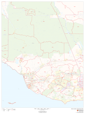
Ventura County, California ZIP Codes (Mainland)
This map of the mainland portion of Ventura County, California shows ZIP code areas overlaid on a road map. Ideal for planning of deliveries, home ervices, sales territories, real estate and much more. Base map features include all roads with major roads and highways labelled; neighborhood names; railways; and high level land use such as parks and recreation areas, industrial areas and hospital campuses.
Page Size: 36 x 48 in (914 x 1219 mm)
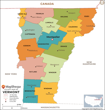
Vermont Counties Map - Extra Large
This map has been created exclusively for MapSherpa, and designed for reference or business use. Clear and clean colors & fonts matched with cartographic research makes this map of the 14 Vermont counties easily readable and useful.
Page Size: 60 x 62.5 in (1524 x 1587 mm)

Vermont Counties Map - Large
This map has been created exclusively for MapSherpa, and designed for reference or business use. Clear and clean colors & fonts matched with cartographic research makes this map of the 14 Vermont counties easily readable and useful.
Page Size: 48 x 50 in (1219 x 1269 mm)

Vermont Counties Map - Standard
This map has been created exclusively for MapSherpa, and designed for reference or business use. Clear and clean colors & fonts matched with cartographic research makes this map of the 14 Vermont counties easily readable and useful.
Page Size: 36 x 37.5 in (914 x 952 mm)
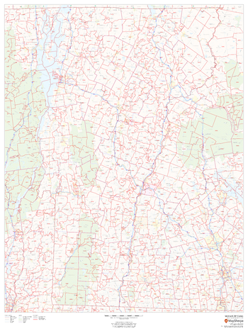
Vermont ZIP Code Map
This map of Vermont shows ZIP code areas overlaid on a road map. Ideal for planning of deliveries, home services, sales territories, real estate and much more. Base map features include all roads with major roads and highways labelled, municipality and county boundaries, neighborhood names, railways, and high level land use such as parks and recreation areas
Page Size: 36 x 48 in (914 x 1219 mm)
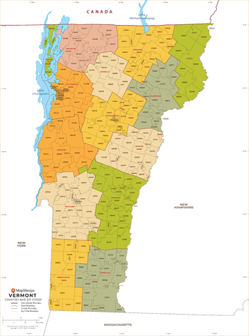
Vermont ZIP Code Map with Counties - Extra Large
This map has been created exclusively for MapSherpa, and designed for business or reference use. Clear and clean colors & fonts matched with cartographic research makes this map of Vermont's counties and ZIP codes easily readable and useful.
Page Size: 60 x 81 in (1524 x 2053 mm)

Vermont ZIP Code Map with Counties - Large
This map has been created exclusively for MapSherpa, and designed for business or reference use. Clear and clean colors & fonts matched with cartographic research makes this map of Vermont's counties and ZIP codes easily readable and useful.
Page Size: 48 x 64.75 in (1219 x 1642 mm)

Vermont ZIP Code Map with Counties - Standard
This map has been created exclusively for MapSherpa, and designed for business or reference use. Clear and clean colors & fonts matched with cartographic research makes this map of Vermont's counties and ZIP codes easily readable and useful.
Page Size: 36 x 48.5 in (914 x 1232 mm)
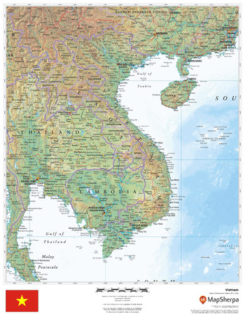
Vietnam
This beautiful map shows physical and political features for Vietnam and surrounding areas. Relief shading and the use of different colours by height above sea level are both informative and attractive.
Page Size: 17 x 22 in (432 x 559 mm)
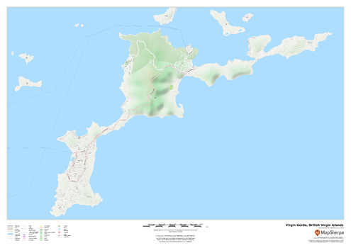
Virgin Gorda, British Virgin Islands
This map of the Virgin Gorda features a full road network for the island including the capital The Valley, walking paths, land use, points of interest, and many of the buildings. Useful for the traveller, and as a wall map for display in your home.
Page Size: 33.25 x 23.5 in (841 x 594 mm)
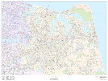
Virginia Beach, Virginia Inner Metro - Landscape
This landscape-oriented map of central Virginia Beach, Virginia shows detailed street level information including extensive street labeling. Ideal for planning of deliveries, home services, sales territories, real estate and much more. Base map features include all roads with major roads and highways labelled; neighborhood names; railways; high level land use such as parks and recreation areas, industrial areas and hospital campuses; and a variety of points of interest including schools, libraries, stadiums, museums, border crossings and more.
Page Size: 48 x 36 in (1219 x 914 mm)
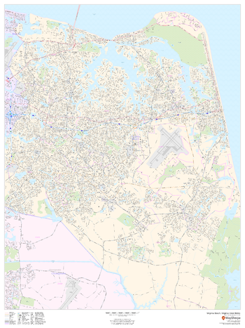
Virginia Beach, Virginia Inner Metro - Portrait
This portrait-oriented map of central Virginia Beach, Virginia shows detailed street level information including extensive street labeling. Ideal for planning of deliveries, home services, sales territories, real estate and much more. Base map features include all roads with major roads and highways labelled; neighborhood names; railways; high level land use such as parks and recreation areas, industrial areas and hospital campuses; and a variety of points of interest including schools, libraries, stadiums, museums, border crossings and more.
Page Size: 36 x 48 in (914 x 1219 mm)
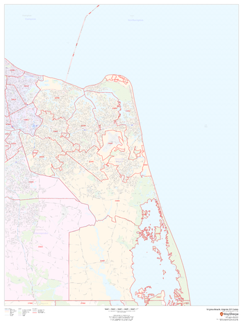
Virginia Beach, Virginia ZIP Codes
This map of Virginia Beach, Virginia shows ZIP code areas overlaid on a road map. Ideal for planning of deliveries, home services, sales territories, real estate and much more. Base map features include all roads with major roads and highways labelled; neighborhood names; railways; and high level land use such as parks and recreation areas, industrial areas and hospital campuses.
Page Size: 36 x 48 in (914 x 1219 mm)
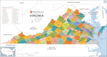
Virginia Counties Map - Extra Large
This map has been created exclusively for MapSherpa, and designed for reference or business use. Clear and clean colors & fonts matched with cartographic research makes this map of Virginia Counties Map easily readable and useful. The map shows the 95 counties of Virginia and their borders across the Old Dominion.
Page Size: 60 x 32.25 in (1524 x 817 mm)

Virginia Counties Map - Large
This map has been created exclusively for MapSherpa, and designed for reference or business use. Clear and clean colors & fonts matched with cartographic research makes this map of Virginia Counties Map easily readable and useful. The map shows the 95 counties of Virginia and their borders across the Old Dominion.
Page Size: 48 x 25.75 in (1219 x 653 mm)

Virginia Counties Map - Standard
This map has been created exclusively for MapSherpa, and designed for reference or business use. Clear and clean colors & fonts matched with cartographic research makes this map of Virginia Counties Map easily readable and useful. The map shows the 95 counties of Virginia and their borders across the Old Dominion.
Page Size: 36 x 19.5 in (914 x 490 mm)
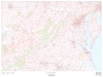
Virginia ZIP Code Map
This map of Virginia shows ZIP codes overlaid on a road map. Base map features include county boundaries, major road network features, and state and national parks and conservation areas.
Page Size: 48 x 36 in (1219 x 914 mm)

Virginia ZIP Code Map with Counties - Extra Large
This map has been created exclusively for MapSherpa, and designed for business or reference use. Clear and clean colors & fonts matched with cartographic research makes this Virginia Zip Code Map with Counties easily readable and useful. The map shows the 95 counties of Virginia and the borders of the over 800 zip codes across the Old Dominion.
Page Size: 60 x 33 in (1524 x 836 mm)

Virginia ZIP Code Map with Counties - Large
This map has been created exclusively for MapSherpa, and designed for business or reference use. Clear and clean colors & fonts matched with cartographic research makes this Virginia Zip Code Map with Counties easily readable and useful. The map shows the 95 counties of Virginia and the borders of the over 800 zip codes across the Old Dominion.
Page Size: 48 x 26.5 in (1219 x 669 mm)
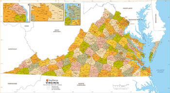
Virginia ZIP Code Map with Counties - Standard
This map has been created exclusively for MapSherpa, and designed for business or reference use. Clear and clean colors & fonts matched with cartographic research makes this Virginia Zip Code Map with Counties easily readable and useful. The map shows the 95 counties of Virginia and the borders of the over 800 zip codes across the Old Dominion.
Page Size: 36 x 19.75 in (914 x 502 mm)