


MapSherpa

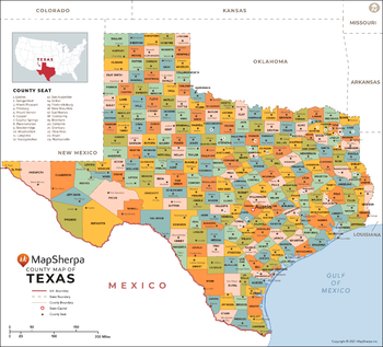
Texas Counties Map - Large
This map has been created exclusively for MapSherpa, and designed for reference or business use. Clear and clean colors & fonts matched with cartographic research makes this map of Texas Counties Map easily readable and useful. The map shows the 254 counties of Texas and their borders across the Lone Star State.
Page Size: 48 x 43.5 in (1219 x 1104 mm)
Texas Counties Map - Standard
This map has been created exclusively for MapSherpa, and designed for reference or business use. Clear and clean colors & fonts matched with cartographic research makes this map of Texas Counties Map easily readable and useful. The map shows the 254 counties of Texas and their borders across the Lone Star State.
Page Size: 36 x 32.75 in (914 x 828 mm)
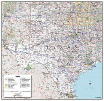
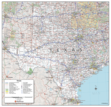
Texas State Wall Map - Compact
This detailed wall map of Texas is perfect for both educational and business purposes. The easy-to-read map features vibrant colors and clear labeling of cities, counties, highways, and geographical features. All national and state highways that connect the state are all clearly labelled on the map, while the legend notes the different road and land use classifications such as urban, park, military, and many more. The boundaries of each county in the state are defined and named clearly. Whether you are a student, teacher, business person or geography enthusiast, this map is a valuable addition to any space.
Page Size: 16 x 15.5 in (406 x 394 mm)
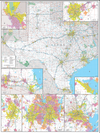
Texas State Wall Map - Extra Large
This detailed wall map of Texas is perfect for both educational and business purposes. The easy-to-read map features vibrant colors and clear labeling of cities, counties, highways, and geographical features. All national and state highways that connect the state are all clearly labelled on the map, while the legend notes the different road and land use classifications such as urban, park, military, and many more. The boundaries of each county in the state are defined and named clearly. Whether you are a student, teacher, business person or geography enthusiast, this map is a valuable addition to any space.
Page Size: 45 x 60 in (1143 x 1524 mm)
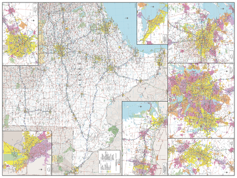
Texas State Wall Map - Large
This detailed wall map of Texas is perfect for both educational and business purposes. The easy-to-read map features vibrant colors and clear labeling of cities, counties, highways, and geographical features. All national and state highways that connect the state are all clearly labelled on the map, while the legend notes the different road and land use classifications such as urban, park, military, and many more. The boundaries of each county in the state are defined and named clearly. Whether you are a student, teacher, business person or geography enthusiast, this map is a valuable addition to any space.
Page Size: 48 x 36 in (1219 x 914 mm)
Texas State Wall Map - Poster
This detailed wall map of Texas is perfect for both educational and business purposes. The easy-to-read map features vibrant colors and clear labeling of cities, counties, highways, and geographical features. All national and state highways that connect the state are all clearly labelled on the map, while the legend notes the different road and land use classifications such as urban, park, military, and many more. The boundaries of each county in the state are defined and named clearly. Whether you are a student, teacher, business person or geography enthusiast, this map is a valuable addition to any space.
Page Size: 27 x 26 in (686 x 660 mm)
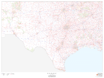
Texas ZIP Code Map
This map of Texas shows ZIP codes overlaid on a road map. Base map features include county boundaries, major road network features, and state and national parks and conservation areas.
Page Size: 48 x 36 in (1219 x 914 mm)

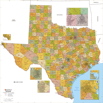
Texas ZIP Code Map with Counties - Extra Large
This map has been created exclusively for MapSherpa, and designed for business or reference use. Clear and clean colors & fonts matched with cartographic research makes this Texas Zip Code Map with Counties easily readable and useful. The map shows the 254 counties of Texas and the borders of the over 1,900 zip codes across the Lone Star State.
Page Size: 60 x 60 in (1524 x 1524 mm)

Texas ZIP Code Map with Counties - Large
This map has been created exclusively for MapSherpa, and designed for business or reference use. Clear and clean colors & fonts matched with cartographic research makes this Texas Zip Code Map with Counties easily readable and useful. The map shows the 254 counties of Texas and the borders of the over 1,900 zip codes across the Lone Star State.
Page Size: 48 x 48 in (1219 x 1219 mm)
Texas ZIP Code Map with Counties - Standard
This map has been created exclusively for MapSherpa, and designed for business or reference use. Clear and clean colors & fonts matched with cartographic research makes this Texas Zip Code Map with Counties easily readable and useful. The map shows the 254 counties of Texas and the borders of the over 1,900 zip codes across the Lone Star State.
Page Size: 36 x 36 in (914 x 914 mm)
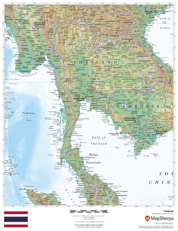
Thailand
This beautiful map shows physical and political features for Thailand and surrounding areas. Relief shading and the use of different colours by height above sea level are both informative and attractive.
Page Size: 17 x 22 in (432 x 559 mm)
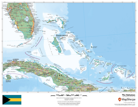
The Bahamas
This beautiful map shows physical and political features for the Bahamas and surrounding areas. Relief shading and the use of different colours by height above sea level are both informative and attractive.
Page Size: 22 x 17 in (559 x 432 mm)
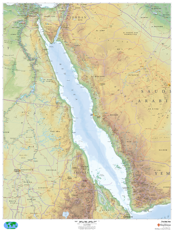
The Red Sea
This beautiful map shows physical and political features for the Red Sea and surrounding areas. Relief shading and the use of different colours by height above sea level are both informative and attractive.
Page Size: 36 x 48 in (914 x 1219 mm)
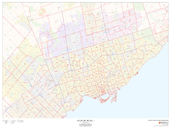
Toronto, Ontario Postal Code Forward Sortation Areas
This map of Toronto shows postal code forward sortation areas overlaid on a road map. Ideal for planning of deliveries, home services, sales territories, real estate and much more. Base map features include all roads with major roads and highways labelled; neighbourhood names; railways; and high level land use such as parks and recreation areas, industrial areas and hospital campuses.
Page Size: 48 x 36 in (1219 x 914 mm)
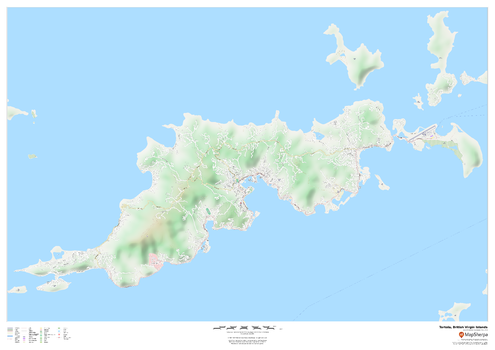
Tortola, British Virgin Islands
This map of the Tortola features a full road network for the island including the capital The Valley, walking paths, land use, points of interest, and many of the buildings. Useful for the traveller, and as a wall map for display in your home.
Page Size: 47 x 33.25 in (1189 x 841 mm)
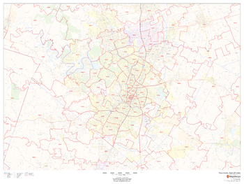
Travis County, Texas
This map of Travis County, Texas shows regional level information. Base map features include highways and major roads with labelling; neighborhood names; railways; high level land use such as parks and recreation areas, industrial areas and hospital campuses; and a selection of points of interest including transportation hubs like airports and train stations, tourist information, police stations and shopping centres. ZIP code boundaries are shown as a secondary map feature.
Page Size: 48 x 36 in (1219 x 914 mm)
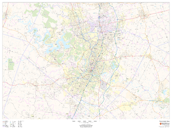
Travis County, Texas ZIP Codes
This map of Travis County, Texas shows ZIP code areas overlaid on a road map. Ideal for planning of deliveries, home services, sales territories, real estate and much more. Base map features include all roads with major roads and highways labelled; neighborhood names; railways; and high level land use such as parks and recreation areas, industrial areas and hospital campuses.
Page Size: 48 x 36 in (1219 x 914 mm)
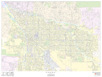
Tucson, Arizona Inner Metro - Landscape
This landscape-oriented map of central Tucson, Arizona shows detailed street level information including extensive street labeling. Ideal for planning of deliveries, home services, sales territories, real estate and much more. Base map features include all roads with major roads and highways labelled; neighborhood names; railways; high level land use such as parks and recreation areas, industrial areas and hospital campuses; and a variety of points of interest including schools, libraries, stadiums, museums, border crossings and more.
Page Size: 48 x 36 in (1219 x 914 mm)
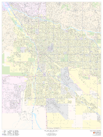
Tucson, Arizona Inner Metro - Portrait
This portrait-oriented map of central Tucson, Arizona shows detailed street level information including extensive street labeling. Ideal for planning of deliveries, home services, sales territories, real estate and much more. Base map features include all roads with major roads and highways labelled; neighborhood names; railways; high level land use such as parks and recreation areas, industrial areas and hospital campuses; and a variety of points of interest including schools, libraries, stadiums, museums, border crossings and more.
Page Size: 36 x 48 in (914 x 1219 mm)
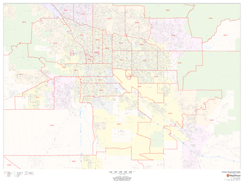
Tucson, Arizona ZIP Codes
This map of Tucson, Arizona shows ZIP code areas overlaid on a road map. Ideal for planning of deliveries, home services, sales territories, real estate and much more. Base map features include all roads with major roads and highways labelled; neighborhood names; railways; and high level land use such as parks and recreation areas, industrial areas and hospital campuses.
Page Size: 48 x 36 in (1219 x 914 mm)