


MapSherpa
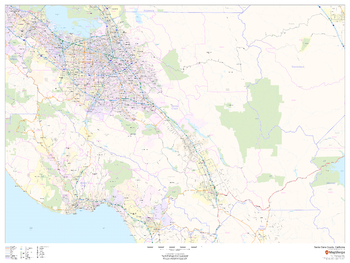
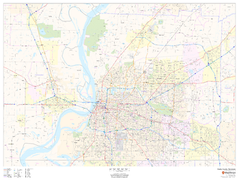
Santa Clara County, California
This map of Santa Clara County, California shows regional level information. Base map features include highways and major roads with labelling; railways; high level land use such as parks and recreation areas; and a selection of points of interest including transportation hubs like airports and train stations, tourist information and police stations. ZIP code boundaries are shown as a secondary map feature.
Page Size: 48 x 36 in (1219 x 914 mm)
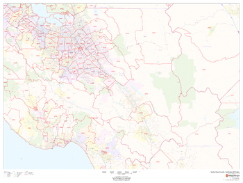
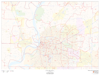
Santa Clara County, California ZIP Codes
This map of Santa Clara County, California shows ZIP code areas overlaid on a road map. Ideal for planning of deliveries, home services, sales territories, real estate and much more. Base map features include all roads with major roads and highways labelled; neighborhood names; railways; and high level land use such as parks and recreation areas, industrial areas and hospital campuses.
Page Size: 48 x 36 in (1219 x 914 mm)
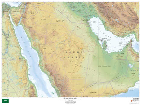
Saudi Arabia
This beautiful map shows physical and political features for Saudi Arabia and surrounding areas. Relief shading and the use of different colours by height above sea level are both informative and attractive.
Page Size: 48 x 36 in (1219 x 914 mm)
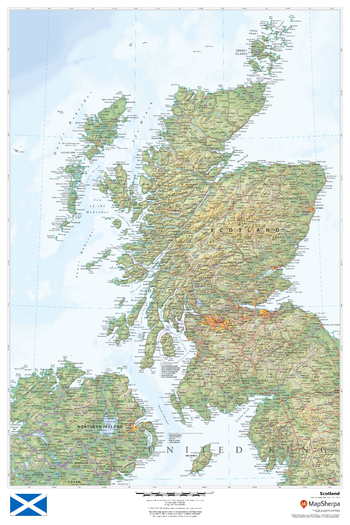
Scotland
This beautiful map shows physical and political features for Scotland and surrounding areas. Relief shading and the use of different colours by height above sea level are both informative and attractive.
Page Size: 24 x 36 in (610 x 914 mm)
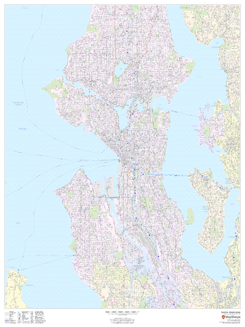
Seattle, Washington - Portrait
This portrait-oriented map of Seattle, Washington shows detailed street level information including extensive street labeling. Ideal for planning of deliveries, home services, sales territories, real estate and much more. Base map features include all roads with major roads and highways labelled; neighborhood names; railways; high level land use such as parks and recreation areas, industrial areas and hospital campuses; and a variety of points of interest including schools, libraries, stadiums, museums, border crossings and more.
Page Size: 36 x 48 in (914 x 1219 mm)
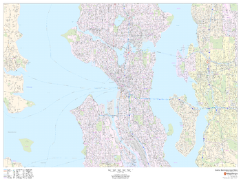
Seattle, Washington Inner Metro - Landscape
This landscape-oriented map of central Seattle, Washington shows detailed street level information including extensive street labeling. Ideal for planning of deliveries, home services, sales territories, real estate and much more. Base map features include all roads with major roads and highways labelled; neighborhood names; railways; high level land use such as parks and recreation areas, industrial areas and hospital campuses; and a variety of points of interest including schools, libraries, stadiums, museums, border crossings and more.
Page Size: 48 x 36 in (1219 x 914 mm)
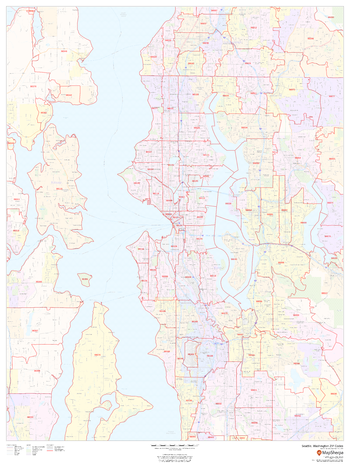
Seattle, Washington ZIP Codes
This map of Seattle shows ZIP code areas overlaid on a road map. Ideal for planning of deliveries, home services, sales territories, real estate and much more. Base map features include all roads with major roads and highways labelled; neighborhood names; railways; and high level land use such as parks and recreation areas, industrial areas and hospital campuses.
Page Size: 36 x 48 in (914 x 1219 mm)
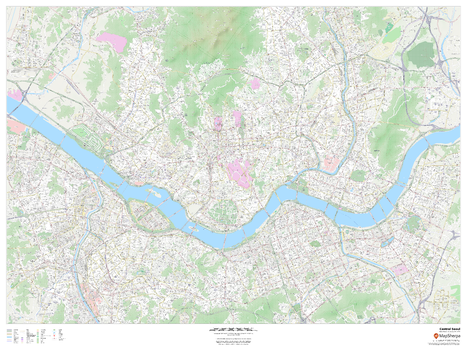
Seoul, South Korea Inner Metro
This detailed street map of central Seoul, South Korea shows the full road and rail networks, points of interest, and land use across the city. Useful for locating yourself within the city, and identifying key landmarks. Map includes building footprints for most urban buildings, providing an important aid for navigating in the city.
Page Size: 48 x 36 in (1219 x 914 mm)
Shelby County, Tennessee
This map of Shelby County, Tennessee shows regional level information. Base map features include highways and major roads with labelling; neighborhood names; railways; high level land use such as parks and recreation areas, industrial areas and hospital campuses; and a selection of points of interest including transportation hubs like airports and train stations, tourist information, police stations and shopping centres. ZIP code boundaries are shown as a secondary map feature.
Page Size: 48 x 36 in (1219 x 914 mm)
Shelby County, Tennessee ZIP Codes
This map of Shelby County, Tennessee shows ZIP code areas overlaid on a road map. Ideal for planning of deliveries, home services, sales territories, real estate and much more. Base map features include all roads with major roads and highways labelled; neighborhood names; railways; and high level land use such as parks and recreation areas, industrial areas and hospital campuses.
Page Size: 48 x 36 in (1219 x 914 mm)
Site Plan - Black and White
Site Plan - Colour
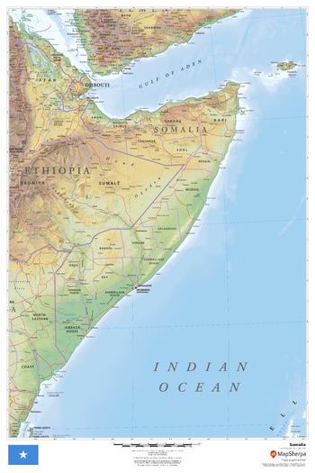
Somalia
This beautiful map shows physical and political features for Somalia and surrounding areas. Relief shading and the use of different colours by height above sea level are both informative and attractive.
Page Size: 24 x 36 in (610 x 914 mm)
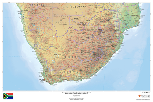
South Africa
This beautiful map shows physical and political features for South Africa and surrounding areas. Relief shading and the use of different colours by height above sea level are both informative and attractive.
Page Size: 36 x 24 in (914 x 610 mm)

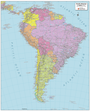
South America Political Map
Created specifically for MapSherpa, this South America Political Map shows all the countries that make up the continent; from Colombia in the north, to the end of Tierra del Fuego of Argentina and Chile to the south. Each country and its capital and major cities are noted, as well as the primary physical features such as mountain ranges, rivers, and lakes. The major islands and their associated countries are noted. With multiple sizes available, this is the perfect reference map for home, office, or school use.
Page Size: 24.25 x 29.5 in (610 x 749 mm)
South America Political Map - Compact
Created specifically for MapSherpa, this South America Political Map shows all the countries that make up the continent; from Colombia in the north, to the end of Tierra del Fuego of Argentina and Chile to the south. Each country and its capital and major cities are noted, as well as the primary physical features such as mountain ranges, rivers, and lakes. The major islands and their associated countries are noted. With multiple sizes available, this is the perfect reference map for home, office, or school use.
Page Size: 16 x 19.75 in (406 x 502 mm)

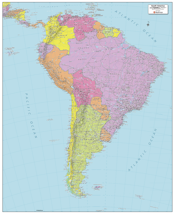
South America Political Map - Extra Large
Created specifically for MapSherpa, this South America Political Map shows all the countries that make up the continent; from Colombia in the north, to the end of Tierra del Fuego of Argentina and Chile to the south. Each country and its capital and major cities are noted, as well as the primary physical features such as mountain ranges, rivers, and lakes. The major islands and their associated countries are noted. With multiple sizes available, this is the perfect reference map for home, office, or school use.
Page Size: 40 x 49 in (1016 x 1245 mm)
South America Political Map - Large
Created specifically for MapSherpa, this South America Political Map shows all the countries that make up the continent; from Colombia in the north, to the end of Tierra del Fuego of Argentina and Chile to the south. Each country and its capital and major cities are noted, as well as the primary physical features such as mountain ranges, rivers, and lakes. The major islands and their associated countries are noted. With multiple sizes available, this is the perfect reference map for home, office, or school use.
Page Size: 32 x 39 in (813 x 991 mm)
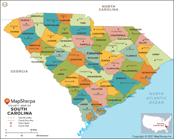
South Carolina Counties Map - Extra Large
This map has been created exclusively for MapSherpa, and designed for reference or business use. Clear and clean colors & fonts matched with cartographic research makes this map of South Carolina Counties Map easily readable and useful. The map shows the 46 counties of South Carolina and their borders across the Palmetto State.
Page Size: 60 x 48.25 in (1524 x 1220 mm)
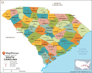
South Carolina Counties Map - Large
This map has been created exclusively for MapSherpa, and designed for reference or business use. Clear and clean colors & fonts matched with cartographic research makes this map of South Carolina Counties Map easily readable and useful. The map shows the 46 counties of South Carolina and their borders across the Palmetto State.
Page Size: 48 x 38.5 in (1219 x 976 mm)