


MapSherpa
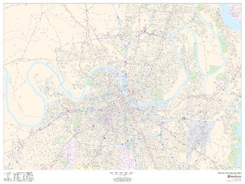
Nashville, Tennessee Inner Metro - Landscape
This landscape-oriented map of central Nashville, Tennessee shows detailed street level information including extensive street labeling. Ideal for planning of deliveries, home services, sales territories, real estate and much more. Base map features include all roads with major roads and highways labelled; neighborhood names; railways; high level land use such as parks and recreation areas, industrial areas and hospital campuses; and a variety of points of interest including schools, libraries, stadiums, museums, border crossings and more.
Page Size: 48 x 36 in (1219 x 914 mm)
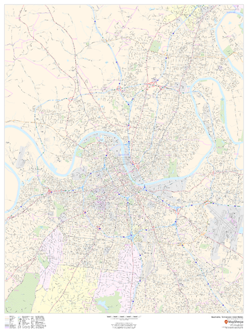
Nashville, Tennessee Inner Metro - Portrait
This portrait-oriented map of central Nashville, Tennessee shows detailed street level information including extensive street labeling. Ideal for planning of deliveries, home services, sales territories, real estate and much more. Base map features include all roads with major roads and highways labelled; neighborhood names; railways; high level land use such as parks and recreation areas, industrial areas and hospital campuses; and a variety of points of interest including schools, libraries, stadiums, museums, border crossings and more.
Page Size: 36 x 48 in (914 x 1219 mm)
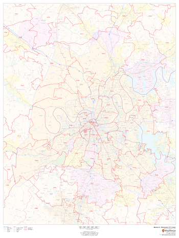
Nashville, Tennessee ZIP Codes
This map of Nashville shows ZIP code areas overlaid on a road map. Ideal for planning of deliveries, home services, sales territories, real estate and much more. Base map features include all roads with major roads and highways labelled; neighborhood names; railways; and high level land use such as parks and recreation areas, industrial areas and hospital campuses.
Page Size: 36 x 48 in (914 x 1219 mm)
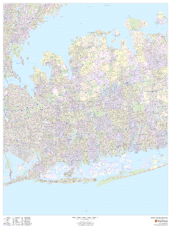
Nassau County, New York
This map of Nassau County, New York shows street level information including street labeling. Base map features include all roads with major roads and highways labelled; neighborhood names; railways; high level land use such as parks and recreation areas, industrial areas and hospital campuses; and a variety of points of interest including libraries, stadiums, museums, border crossings and more. ZIP code boundaries are shown as a secondary map feature.
Page Size: 36 x 48 in (914 x 1219 mm)

Nassau County, New York ZIP Codes
This map of Nassau County, New York shows ZIP code areas overlaid on a road map. Ideal for planning of deliveries, home services, sales territories, real estate and much more. Base map features include all roads with major roads and highways labelled; neighborhood names; railways; and high level land use such as parks and recreation areas, industrial areas and hospital campuses.
Page Size: 36 x 48 in (914 x 1219 mm)
Natural World
This Physical World Map makes great use of place names pointing out the world’s physical and water features. Shaded relief for both the land and ocean floors are shown, along with land coloring to represent the land use. From islands to capes to peaks, and seas to rivers to lakes, and so much more, this Physical World Map is an outstanding addition to any home or place of learning.
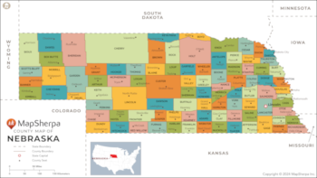
Nebraska Counties Map - Extra Large
This map has been created exclusively for MapSherpa, and designed for reference or business use. Clear and clean colors & fonts matched with cartographic research makes this map of the 93 Nebraska counties easily readable and useful.
Page Size: 60 x 33.75 in (1524 x 856 mm)

Nebraska Counties Map - Large
This map has been created exclusively for MapSherpa, and designed for reference or business use. Clear and clean colors & fonts matched with cartographic research makes this map of the 93 Nebraska counties easily readable and useful.
Page Size: 48 x 27 in (1219 x 685 mm)

Nebraska Counties Map - Standard
This map has been created exclusively for MapSherpa, and designed for reference or business use. Clear and clean colors & fonts matched with cartographic research makes this map of the 93 Nebraska counties easily readable and useful.
Page Size: 36 x 20.25 in (914 x 514 mm)
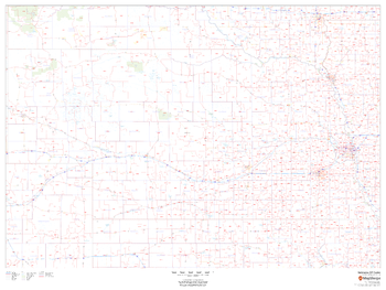
Nebraska ZIP Code Map
This map of Nebraska shows ZIP codes overlaid on a road map. Base map features include county boundaries, major road network features, and state and national parks and conservation areas.
Page Size: 48 x 36 in (1219 x 914 mm)

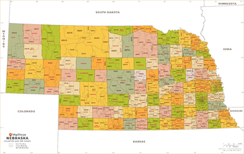
Nebraska ZIP Code Map with Counties - Extra Large
This map has been created exclusively for MapSherpa, and designed for business or reference use. Clear and clean colors & fonts matched with cartographic research makes this map of Nebraska's counties and ZIP codes easily readable and useful.
Page Size: 60 x 38.25 in (1524 x 968 mm)

Nebraska ZIP Code Map with Counties - Large
This map has been created exclusively for MapSherpa, and designed for business or reference use. Clear and clean colors & fonts matched with cartographic research makes this map of Nebraska's counties and ZIP codes easily readable and useful.
Page Size: 48 x 30.5 in (1219 x 774 mm)
Nebraska ZIP Code Map with Counties - Standard
This map has been created exclusively for MapSherpa, and designed for business or reference use. Clear and clean colors & fonts matched with cartographic research makes this map of Nebraska's counties and ZIP codes easily readable and useful.
Page Size: 36 x 23 in (914 x 581 mm)

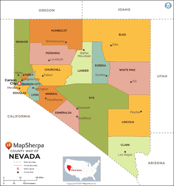
Nevada Counties Map - Extra Large
This map has been created exclusively for MapSherpa, and designed for reference or business use. Clear and clean colors & fonts matched with cartographic research makes this map of Nevada Counties Map easily readable and useful. The map shows the 16 counties of Nevada and their borders across the Silver State.
Page Size: 60 x 64.5 in (1524 x 1635 mm)
Nevada Counties Map - Large
This map has been created exclusively for MapSherpa, and designed for reference or business use. Clear and clean colors & fonts matched with cartographic research makes this map of Nevada Counties Map easily readable and useful. The map shows the 16 counties of Nevada and their borders across the Silver State.
Page Size: 48 x 51.5 in (1219 x 1308 mm)

Nevada Counties Map - Standard
This map has been created exclusively for MapSherpa, and designed for reference or business use. Clear and clean colors & fonts matched with cartographic research makes this map of Nevada Counties Map easily readable and useful. The map shows the 16 counties of Nevada and their borders across the Silver State.
Page Size: 36 x 38.75 in (914 x 981 mm)
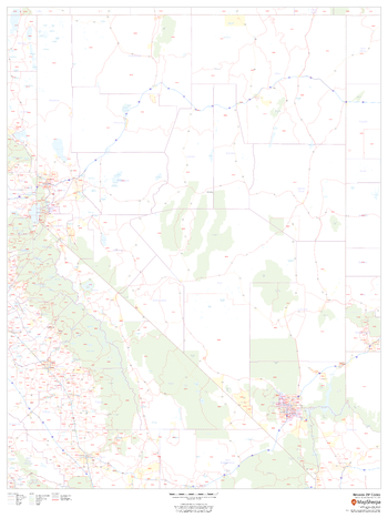
Nevada ZIP Code Map
This map of Nevada shows ZIP codes overlaid on a road map. Base map features include county boundaries, major road network features, and state and national parks and conservation areas.
Page Size: 36 x 48 in (914 x 1219 mm)
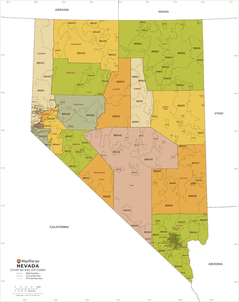
Nevada ZIP Code Map with Counties - Extra Large
This map has been created exclusively for MapSherpa, and designed for business or reference use. Clear and clean colors & fonts matched with cartographic research makes this Nevada Zip Code Map with Counties easily readable and useful. The map shows the 16 counties of Nevada and the borders of the 159 zip codes across the Silver State.
Page Size: 60 x 75.75 in (1524 x 1920 mm)

Nevada ZIP Code Map with Counties - Large
This map has been created exclusively for MapSherpa, and designed for business or reference use. Clear and clean colors & fonts matched with cartographic research makes this Nevada Zip Code Map with Counties easily readable and useful. The map shows the 16 counties of Nevada and the borders of the 159 zip codes across the Silver State.
Page Size: 48 x 60.5 in (1219 x 1536 mm)

Nevada ZIP Code Map with Counties - Standard
This map has been created exclusively for MapSherpa, and designed for business or reference use. Clear and clean colors & fonts matched with cartographic research makes this Nevada Zip Code Map with Counties easily readable and useful. The map shows the 16 counties of Nevada and the borders of the 159 zip codes across the Silver State.
Page Size: 36 x 45.5 in (914 x 1152 mm)