


MapSherpa
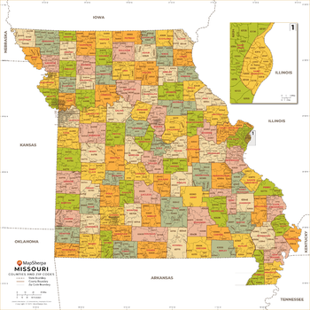
Missouri ZIP Code Map with Counties - Large
This map has been created exclusively for MapSherpa, and designed for business or reference use. Clear and clean colors & fonts matched with cartographic research makes this map of Missouri's counties and ZIP codes easily readable and useful.
Page Size: 48 x 48 in (1219 x 1219 mm)

Missouri ZIP Code Map with Counties - Standard
This map has been created exclusively for MapSherpa, and designed for business or reference use. Clear and clean colors & fonts matched with cartographic research makes this map of Missouri's counties and ZIP codes easily readable and useful.
Page Size: 36 x 36 in (914 x 914 mm)
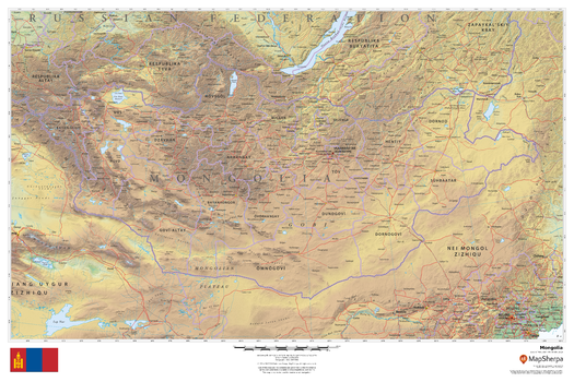
Mongolia
This beautiful map shows physical and political features for Mongolia and surrounding areas. Relief shading and the use of different colours by height above sea level are both informative and attractive.
Page Size: 36 x 24 in (914 x 610 mm)

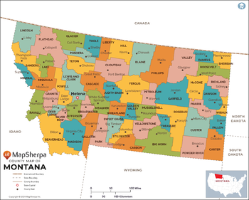
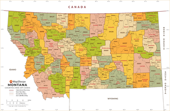
Montana Counties Map - Extra Large
This map has been created exclusively for MapSherpa, and designed for reference or business use. Clear and clean colors & fonts matched with cartographic research makes this map of the 56 Montana counties easily readable and useful.
Page Size: 60 x 48.25 in (1524 x 1222 mm)

Montana Counties Map - Large
This map has been created exclusively for MapSherpa, and designed for reference or business use. Clear and clean colors & fonts matched with cartographic research makes this map of the 56 Montana counties easily readable and useful.
Page Size: 48 x 38.5 in (1219 x 977 mm)
Montana Counties Map - Standard
This map has been created exclusively for MapSherpa, and designed for reference or business use. Clear and clean colors & fonts matched with cartographic research makes this map of the 56 Montana counties easily readable and useful.
Page Size: 36 x 29 in (914 x 733 mm)
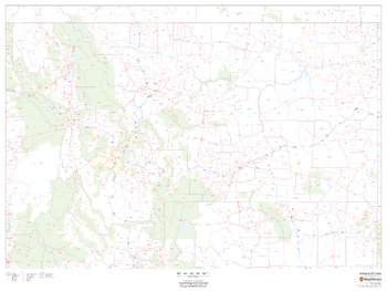
Montana ZIP Code Map
This map of Montana shows ZIP codes overlaid on a road map. Base map features include county boundaries, major road network features, and state and national parks and conservation areas.
Page Size: 48 x 36 in (1219 x 914 mm)

Montana ZIP Code Map with Counties - Extra Large
This map has been created exclusively for MapSherpa, and designed for business or reference use. Clear and clean colors & fonts matched with cartographic research makes this map of Montana's counties and ZIP codes easily readable and useful.
Page Size: 60 x 39.25 in (1524 x 995 mm)
Montana ZIP Code Map with Counties - Large
This map has been created exclusively for MapSherpa, and designed for business or reference use. Clear and clean colors & fonts matched with cartographic research makes this map of Montana's counties and ZIP codes easily readable and useful.
Page Size: 48 x 31.5 in (1219 x 796 mm)

Montana ZIP Code Map with Counties - Standard
This map has been created exclusively for MapSherpa, and designed for business or reference use. Clear and clean colors & fonts matched with cartographic research makes this map of Montana's counties and ZIP codes easily readable and useful.
Page Size: 36 x 23.75 in (914 x 597 mm)
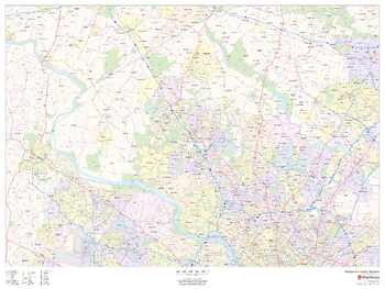
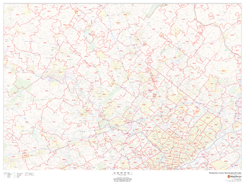
Montgomery County, Maryland
This map of Montgomery County, Maryland shows regional level information. Base map features include highways and major roads with labelling; neighborhood names; railways; high level land use such as parks and recreation areas, industrial areas and hospital campuses; and a selection of points of interest including transportation hubs like airports and train stations, tourist information, police stations and shopping centres. ZIP code boundaries are shown as a secondary map feature.
Page Size: 48 x 36 in (1219 x 914 mm)
Montgomery County, Maryland ZIP Codes
This map of Montgomery County, Maryland shows ZIP code areas overlaid on a road map. Ideal for planning of deliveries, home services, sales territories, real estate and much more. Base map features include all roads with major roads and highways labelled; neighborhood names; railways; and high level land use such as parks and recreation areas, industrial areas and hospital campuses.
Page Size: 48 x 36 in (1219 x 914 mm)
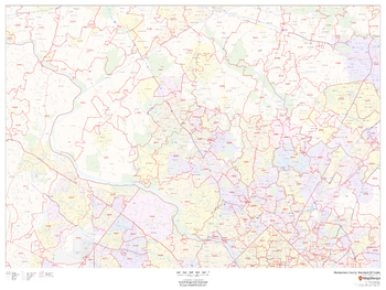
Montgomery County, Pennsylvania
This map of Montgomery County, Pennsylvania shows regional level information. Base map features include highways and major roads with labelling; neighborhood names; railways; high level land use such as parks and recreation areas, industrial areas and hospital campuses; and a selection of points of interest including transportation hubs like airports and train stations, tourist information, police stations and shopping centres. ZIP code boundaries are shown as a secondary map feature.
Page Size: 48 x 36 in (1219 x 914 mm)
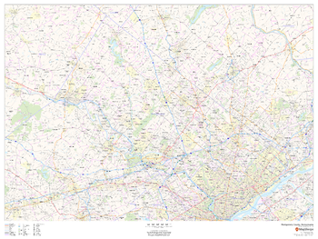
Montgomery County, Pennsylvania ZIP Codes
This map of Montgomery County, Pennsylvania shows ZIP code areas overlaid on a road map. Ideal for planning of deliveries, home ervices, sales territories, real estate and much more. Base map features include all roads with major roads and highways labelled; neighborhood names; railways; and high level land use such as parks and recreation areas, industrial areas and hospital campuses.
Page Size: 48 x 36 in (1219 x 914 mm)
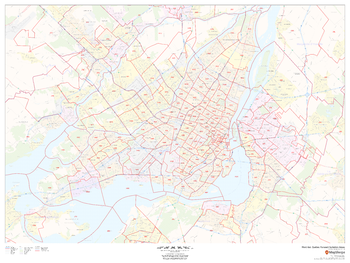
Montréal, Québec Postal Code Forward Sortation Areas
This map of Montreal shows postal code forward sortation areas overlaid on a road map. Ideal for planning of deliveries, home services, sales territories, real estate and much more. Base map features include all roads with major roads and highways labelled; neighbourhood names; railways; and high level land use such as parks and recreation areas, industrial areas and hospital campuses.
Page Size: 48 x 36 in (1219 x 914 mm)
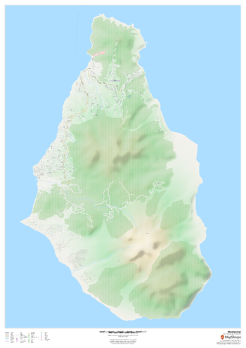
Montserrat
This map of Montserrat features a full detailed road network for the island, trails, land use, points of interest, and almost all buildings. Useful for the traveller, and as a wall map for display in your home.
Page Size: 33.25 x 47 in (841 x 1189 mm)
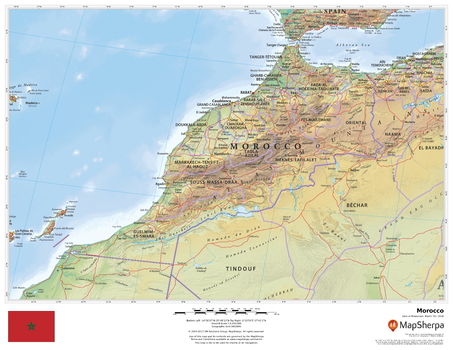
Morocco
This beautiful map shows physical and political features for Morocco and surrounding areas. Relief shading and the use of different colours by height above sea level are both informative and attractive.
Page Size: 22 x 17 in (559 x 432 mm)
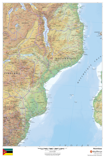
Mozambique
This beautiful map shows physical and political features for Mozambique and surrounding areas. Relief shading and the use of different colours by height above sea level are both informative and attractive.
Page Size: 24 x 36 in (610 x 914 mm)
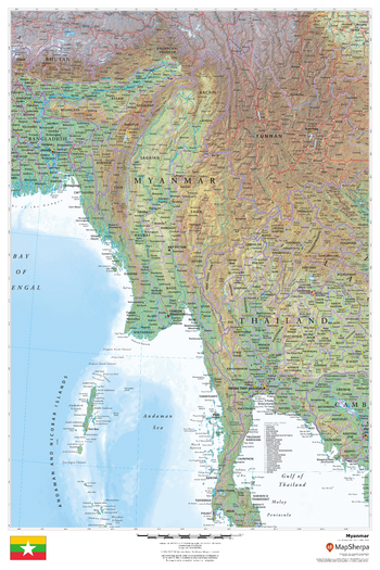
Myanmar
This beautiful map shows physical and political features for the Myanmar and surrounding areas. Relief shading and the use of different colours by height above sea level are both informative and attractive.
Page Size: 24 x 36 in (610 x 914 mm)
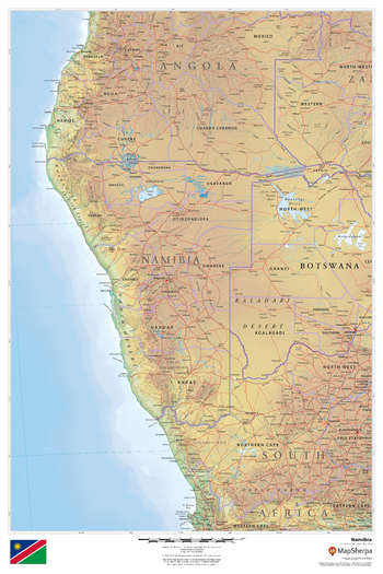
Namibia
This beautiful map shows physical and political features for Namibia and surrounding areas. Relief shading and the use of different colours by height above sea level are both informative and attractive.
Page Size: 24 x 36 in (610 x 914 mm)