


MapSherpa
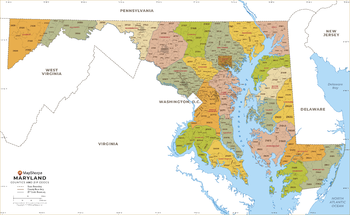
Maryland ZIP Code Map with Counties - Standard
This map has been created exclusively for MapSherpa, and designed for business or reference use. Clear and clean colors & fonts matched with cartographic research makes this Maryland Zip Code Map with Counties easily readable and useful. The map shows the 24 counties of Maryland and the borders of the 467 zip codes across the Old Line State.
Page Size: 36 x 22.25 in (914 x 561 mm)

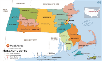
Massachusetts Counties Map - Extra Large
This map has been created exclusively for MapSherpa, and designed for reference or business use. Clear and clean colors & fonts matched with cartographic research makes this map of Massachusetts Counties Map easily readable and useful. The map shows the 14 counties of Massachusetts and their borders across the Bay State.
Page Size: 60 x 36 in (1524 x 913 mm)
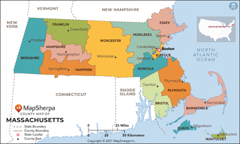
Massachusetts Counties Map - Large
This map has been created exclusively for MapSherpa, and designed for reference or business use. Clear and clean colors & fonts matched with cartographic research makes this map of Massachusetts Counties Map easily readable and useful. The map shows the 14 counties of Massachusetts and their borders across the Bay State.
Page Size: 48 x 29 in (1219 x 731 mm)
Massachusetts Counties Map - Standard
This map has been created exclusively for MapSherpa, and designed for reference or business use. Clear and clean colors & fonts matched with cartographic research makes this map of Massachusetts Counties Map easily readable and useful. The map shows the 14 counties of Massachusetts and their borders across the Bay State.
Page Size: 36 x 21.75 in (914 x 548 mm)
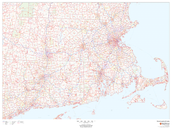
Massachusetts ZIP Code Map
This map of Massachusetts shows ZIP code areas overlaid on a road map. Ideal for planning of deliveries, home services, sales territories, real estate and much more. Base map features include all roads with major roads and highways labelled, municipality and county boundaries, neighborhood names, railways, and high level land use such as parks and recreation areas
Page Size: 48 x 36 in (1219 x 914 mm)

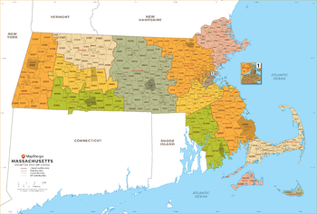
Massachusetts ZIP Code Map with Counties - Extra Large
This map has been created exclusively for MapSherpa, and designed for business or reference use. Clear and clean colors & fonts matched with cartographic research makes this Massachusetts Zip Code Map with Counties easily readable and useful. The map shows the 14 counties of Massachusetts and the borders of the 536 zip codes across the Bay State.
Page Size: 60 x 40.75 in (1524 x 1033 mm)
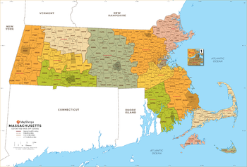
Massachusetts ZIP Code Map with Counties - Large
This map has been created exclusively for MapSherpa, and designed for business or reference use. Clear and clean colors & fonts matched with cartographic research makes this Massachusetts Zip Code Map with Counties easily readable and useful. The map shows the 14 counties of Massachusetts and the borders of the 536 zip codes across the Bay State.
Page Size: 48 x 32.75 in (1219 x 827 mm)
Massachusetts ZIP Code Map with Counties - Standard
This map has been created exclusively for MapSherpa, and designed for business or reference use. Clear and clean colors & fonts matched with cartographic research makes this Massachusetts Zip Code Map with Counties easily readable and useful. The map shows the 14 counties of Massachusetts and the borders of the 536 zip codes across the Bay State.
Page Size: 36 x 24.5 in (914 x 620 mm)
MasterMap B&W 1:1250
The most detailed and comprehensive map data-set of Great Britain from the Ordnance Survey. Mapping data is updated quarterly so maps are always current. Maps are suitable for Planning applications and Land Registry purposes. Maps can be created in black and white at a fixed scale of 1:1,250.
MasterMap B&W 1:1250 Flex
The most detailed and comprehensive map data-set of Great Britain from the Ordnance Survey. Mapping data is updated quarterly so maps are always current. Maps are suitable for Planning applications and Land Registry purposes. Maps can be created in black and white at a flexible scale between 1:420 and 1:1,250.
MasterMap B&W 1:200
The most detailed and comprehensive map data-set of Great Britain from the Ordnance Survey. Mapping data is updated quarterly so maps are always current. Maps are suitable for Planning applications and Land Registry purposes. Maps can be created in black and white at a fixed scale of 1:200.
MasterMap B&W 1:200 Flex
The most detailed and comprehensive map data-set of Great Britain from the Ordnance Survey. Mapping data is updated quarterly so maps are always current. Maps are suitable for Planning applications and Land Registry purposes. Maps can be created in black and white at a flexible scale between 1:25 and 1:200.
MasterMap B&W 1:2500
The most detailed and comprehensive map data-set of Great Britain from the Ordnance Survey. Mapping data is updated quarterly so maps are always current. Maps are suitable for Planning applications and Land Registry purposes. Maps can be created in black and white at a fixed scale of 1:2,500.
MasterMap B&W 1:2500 Flex
The most detailed and comprehensive map data-set of Great Britain from the Ordnance Survey. Mapping data is updated quarterly so maps are always current. Maps are suitable for Planning applications and Land Registry purposes. Maps can be created in black and white at a flexible scale between 1:1,000 and 1:2,500.
MasterMap B&W 1:500
The most detailed and comprehensive map data-set of Great Britain from the Ordnance Survey. Mapping data is updated quarterly so maps are always current. Maps are suitable for Planning applications and Land Registry purposes. Maps can be created in black and white at a fixed scale of 1:500.
MasterMap B&W 1:500 Flex
The most detailed and comprehensive map data-set of Great Britain from the Ordnance Survey. Mapping data is updated quarterly so maps are always current. Maps are suitable for Planning applications and Land Registry purposes. Maps can be created in black and white at a flexible scale between 1:160 and 1:500.
MasterMap Colour 1:1250
The most detailed and comprehensive map data-set of Great Britain from the Ordnance Survey. Mapping data is updated quarterly so maps are always current. Maps are suitable for Planning applications and Land Registry purposes. Maps can be created in colour at a fixed scale of 1:1,250.
MasterMap Colour 1:1250 Flex
The most detailed and comprehensive map data-set of Great Britain from the Ordnance Survey. Mapping data is updated quarterly so maps are always current. Maps are suitable for Planning applications and Land Registry purposes. Maps can be created in colour at a flexible scale between 1:420 and 1:1,250.
MasterMap Colour 1:200
The most detailed and comprehensive map data-set of Great Britain from the Ordnance Survey. Mapping data is updated quarterly so maps are always current. Maps are suitable for Planning applications and Land Registry purposes. Maps can be created in colour at a fixed scale of 1:200.
MasterMap Colour 1:200 Flex
The most detailed and comprehensive map data-set of Great Britain from the Ordnance Survey. Mapping data is updated quarterly so maps are always current. Maps are suitable for Planning applications and Land Registry purposes. Maps can be created in colour at a flexible scale between 1:25 and 1:200.