MapSherpa
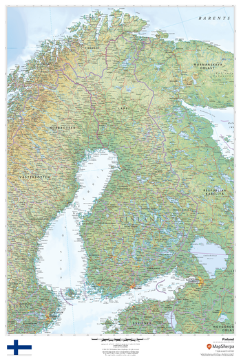
Finland
This beautiful map shows physical and political features for Finland and surrounding areas. Relief shading and the use of different colours by height above sea level are both informative and attractive.
Page Size: 24 x 36 in (610 x 914 mm)
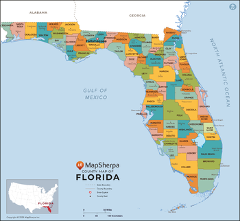
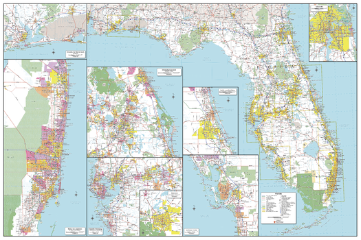
Florida Counties Map - Extra Large
This map has been created exclusively for MapSherpa, and designed for reference or business use. Clear and clean colors & fonts matched with cartographic research makes this map of Florida Counties Map easily readable and useful. The map shows the 67 counties of Florida and their borders across the Sunshine State.
Page Size: 60 x 55.25 in (1524 x 1401 mm)

Florida Counties Map - Large
This map has been created exclusively for MapSherpa, and designed for reference or business use. Clear and clean colors & fonts matched with cartographic research makes this map of Florida Counties Map easily readable and useful. The map shows the 67 counties of Florida and their borders across the Sunshine State.
Page Size: 48 x 44.25 in (1219 x 1121 mm)

Florida Counties Map - Standard
This map has been created exclusively for MapSherpa, and designed for reference or business use. Clear and clean colors & fonts matched with cartographic research makes this map of Florida Counties Map easily readable and useful. The map shows the 67 counties of Florida and their borders across the Sunshine State.
Page Size: 36 x 33.25 in (914 x 841 mm)
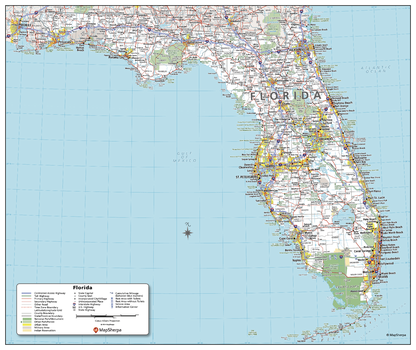
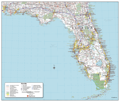
Florida State Wall Map - Compact
This detailed wall map of Florida is perfect for both educational and business purposes. The easy-to-read map features vibrant colors and clear labeling of cities, counties, highways, and geographical features. All national and state highways that connect the state are all clearly labelled on the map, while the legend notes the different road and land use classifications such as urban, park, military, and many more. The boundaries of each county in the state are defined and named clearly. Whether you are a student, teacher, business person or geography enthusiast, this map is a valuable addition to any space.
Page Size: 19 x 16 in (483 x 406 mm)
Florida State Wall Map - Extra Large
This detailed wall map of Florida is perfect for both educational and business purposes. The easy-to-read map features vibrant colors and clear labeling of cities, counties, highways, and geographical features. All national and state highways that connect the state are all clearly labelled on the map, while the legend notes the different road and land use classifications such as urban, park, military, and many more. The boundaries of each county in the state are defined and named clearly. Whether you are a student, teacher, business person or geography enthusiast, this map is a valuable addition to any space.
Page Size: 60 x 40 in (1524 x 1016 mm)
Florida State Wall Map - Large
This detailed wall map of Florida is perfect for both educational and business purposes. The easy-to-read map features vibrant colors and clear labeling of cities, counties, highways, and geographical features. All national and state highways that connect the state are all clearly labelled on the map, while the legend notes the different road and land use classifications such as urban, park, military, and many more. The boundaries of each county in the state are defined and named clearly. Whether you are a student, teacher, business person or geography enthusiast, this map is a valuable addition to any space.
Page Size: 48 x 32 in (1219 x 813 mm)
Florida State Wall Map - Poster
This detailed wall map of Florida is perfect for both educational and business purposes. The easy-to-read map features vibrant colors and clear labeling of cities, counties, highways, and geographical features. All national and state highways that connect the state are all clearly labelled on the map, while the legend notes the different road and land use classifications such as urban, park, military, and many more. The boundaries of each county in the state are defined and named clearly. Whether you are a student, teacher, business person or geography enthusiast, this map is a valuable addition to any space.
Page Size: 29 x 24.5 in (737 x 622 mm)
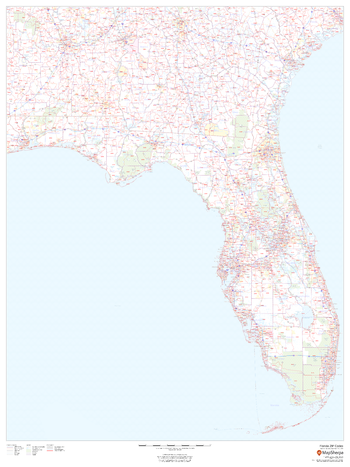
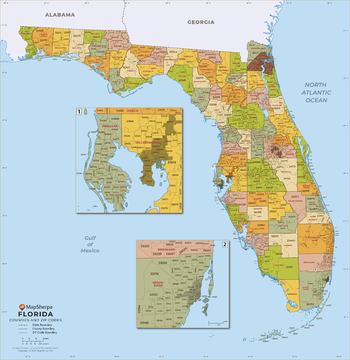
Florida ZIP Code Map
This map of Florida shows ZIP codes overlaid on a road map. Base map features include county boundaries, major road network features, and state and national parks and conservation areas.
Page Size: 36 x 48 in (914 x 1219 mm)

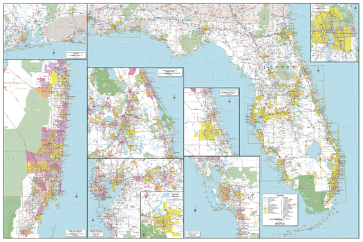
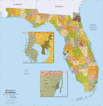
Florida ZIP Code Map with Counties - Extra Large
This map has been created exclusively for MapSherpa, and designed for business or reference use. Clear and clean colors & fonts matched with cartographic research makes this Florida Zip Code Map with Counties easily readable and useful. The map shows the 67 counties of Florida and the borders of the over 900 zip codes across the Sunshine State.
Page Size: 60 x 62 in (1524 x 1569 mm)
Florida ZIP Code Map with Counties - Large
This map has been created exclusively for MapSherpa, and designed for business or reference use. Clear and clean colors & fonts matched with cartographic research makes this Florida Zip Code Map with Counties easily readable and useful. The map shows the 67 counties of Florida and the borders of the over 900 zip codes across the Sunshine State.
Page Size: 48 x 49.5 in (1219 x 1255 mm)
Florida ZIP Code Map with Counties - Standard
This map has been created exclusively for MapSherpa, and designed for business or reference use. Clear and clean colors & fonts matched with cartographic research makes this Florida Zip Code Map with Counties easily readable and useful. The map shows the 67 counties of Florida and the borders of the over 900 zip codes across the Sunshine State.
Page Size: 36 x 37.25 in (914 x 941 mm)
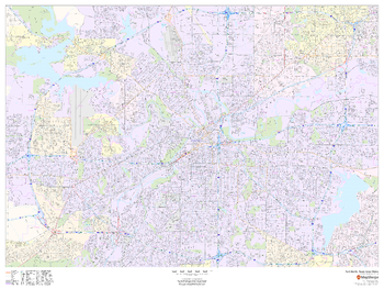
Fort Worth, Texas Inner Metro - Landscape
This landscape-oriented map of central Fort Worth, Texas shows detailed street level information including extensive street labeling. Ideal for planning of deliveries, home services, sales territories, real estate and much more. Base map features include all roads with major roads and highways labelled; neighborhood names; railways; high level land use such as parks and recreation areas, industrial areas and hospital campuses; and a variety of points of interest including schools, libraries, stadiums, museums, border crossings and more.
Page Size: 48 x 36 in (1219 x 914 mm)
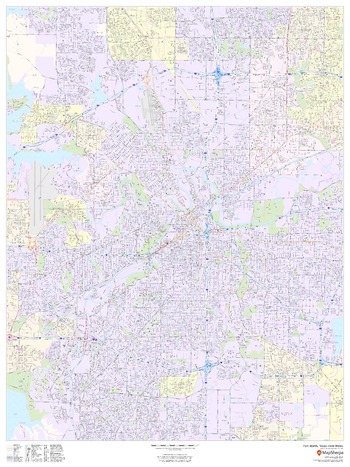
Fort Worth, Texas Inner Metro - Portrait
This portrait-oriented map of central Fort Worth, Texas shows detailed street level information including extensive street labeling. Ideal for planning of deliveries, home services, sales territories, real estate and much more. Base map features include all roads with major roads and highways labelled; neighborhood names; railways; high level land use such as parks and recreation areas, industrial areas and hospital campuses; and a variety of points of interest including schools, libraries, stadiums, museums, border crossings and more.
Page Size: 36 x 48 in (914 x 1219 mm)
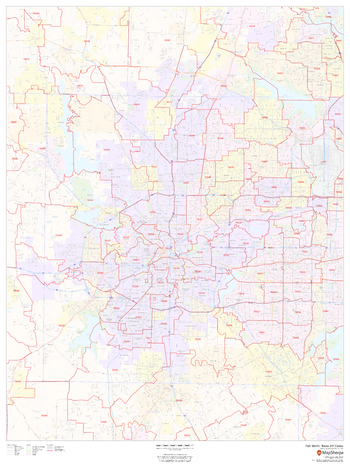
Fort Worth, Texas ZIP Codes
This map of Fort Worth shows ZIP code areas overlaid on a road map. Ideal for planning of deliveries, home services, sales territories, real estate and much more. Base map features include all roads with major roads and highways labelled; neighborhood names; railways; and high level land use such as parks and recreation areas, industrial areas and hospital campuses.
Page Size: 36 x 48 in (914 x 1219 mm)
France Explorer
This versatile product allows you to get a topographic map of anywhere in France. It has been designed so you can create a map for your next excursion.This product has been designed to make custom topographic maps suitable for short walks to week long treks and anything in between. Walking and bike paths are featured prominently on this map along with key points of interest such as campsites, trailheads, and landmarks. Also included are traditional topographic features such as elevation contours, landforms, lakes, and rivers along with roads, rails, trails, and park boundaries.The details of this map make it ideal to plan your next trek and take it with you. Invaluable for outdoor recreation activities such as walking, biking, and exploration.
France Roads and Recreation
This versatile product allows you to get a road map of anywhere in France. It has been designed so you can create a map for your next trip.This product has been designed to make custom road and street maps suitable for road trips and sightseeing. This map features comprehensive points of interest including attractions, landmarks, amenities, scenic views and local foot and bike paths. Also included is a complete network of highways, streets and roads you can count on.The details of this map make it ideal to plan a trip and take it with you. Travel with confidence using a map created specifically for the area you will be discovering.
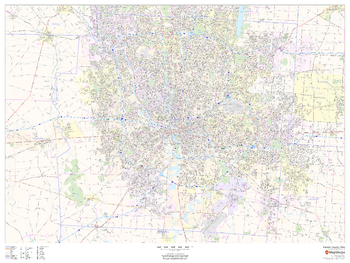
Franklin County, Ohio
This map of Franklin County, Ohio shows regional level information. Base map features include highways and major roads with labelling; neighborhood names; railways; high level land use such as parks and recreation areas, industrial areas and hospital campuses; and a selection of points of interest including transportation hubs like airports and train stations, tourist information, police stations and shopping centres. ZIP code boundaries are shown as a secondary map feature.
Page Size: 48 x 36 in (1219 x 914 mm)
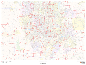
Franklin County, Ohio ZIP Codes
This map of Franklin County, Ohio shows ZIP code areas overlaid on a road map. Ideal for planning of deliveries, home services, sales territories, real estate and much more. Base map features include all roads with major roads and highways labelled; neighborhood names; railways; and high level land use such as parks and recreation areas, industrial areas and hospital campuses.
Page Size: 48 x 36 in (1219 x 914 mm)
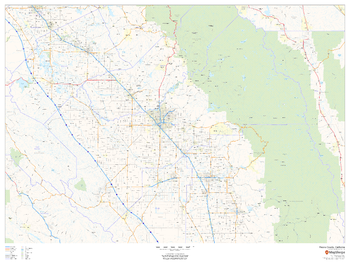
Fresno County, California
This map of Fresno County, California shows regional level information. Base map features include highways and major roads with highway numbering and high level land use such as parks and recreation areas.
Page Size: 48 x 36 in (1219 x 914 mm)