Globe Turner
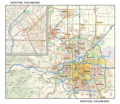
Denver, Colorado Wall Map, large
This detailed reference map combines two maps in one - a regional map of metropolitan Denver plus a street-level map of downtown Denver. The area’s cities and towns, highways and roads, and a variety of points of interest are depicted on the regional map. Boulder, Aurora, and Golden are among the cities surrounding Denver that are shown. The map is beautifully rendered with terrain relief. The highly detailed inset of Denver’s business district shows highways, streets, parks, landmarks, and other points of interest. The state capitol, Coors Field, and the U.S. Mint are among the many points of interest shown on this map. Also available in a small size of 22.50" wide X 19.50" high.
Page Size: 22.75 x 19.5 in (572 x 495 mm)
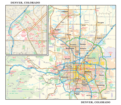
Denver, Colorado Wall Map, small
This detailed reference map combines two maps in one - a regional map of metropolitan Denver plus a street-level map of downtown Denver. The area’s cities and towns, highways and roads, and a variety of points of interest are depicted on the regional map. Boulder, Aurora, and Golden are among the cities surrounding Denver that are shown. The map is beautifully rendered with terrain relief. The highly detailed inset of Denver’s business district shows highways, streets, parks, landmarks, and other points of interest. The state capitol, Coors Field, and the U.S. Mint are among the many points of interest shown on this map. Also available in a large size of 22.50" wide X 19.50" high.
Page Size: 11.25 x 9.75 in (286 x 248 mm)
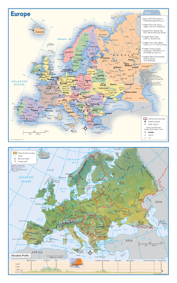
Europe Political & Physical Continent Map
This map of the European continent combines two maps in one - a vivid political map of Europe showing all of the countries and major cities as well as a colorful topographic physical map depicting all of the major physical features in Europe, including a cross-continent elevation profile. The political map includes a call-out box with interesting facts about the continent.
Page Size: 10.75 x 17 in (271 x 432 mm)
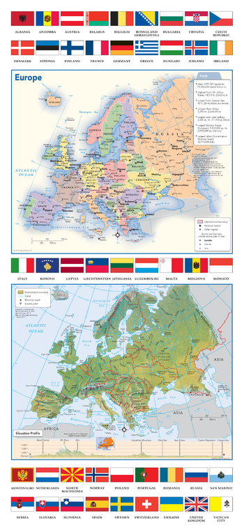
Europe Political & Physical Continent Map with Country Flags
This map of the European continent combines two maps in one - a vivid political map of Europe showing all of the countries and major cities as well as a colorful topographic physical map depicting all of the major physical features in Europe, including a cross-continent elevation profile. The political map includes a call-out box with interesting facts about the continent. The map also includes all 45 flags each European country.
Page Size: 10.75 x 23.25 in (271 x 587 mm)
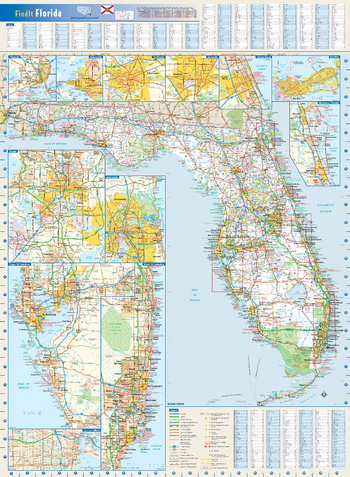
Florida State Wall Map
This colorful, easy-to-read state map of Florida identifies all major thoroughfares, secondary roads, freeway interchanges, rest areas, distance markers, landmarks, recreational areas, and more. Shaded relief on the state map provides a three-dimensional sense of Florida's topography. Detailed city inset maps of Daytona Beach, Gainesville, Jacksonville, Key West, Melbourne/Titusville, Miami/Fort Lauderdale, Orlando, Panama City, Pensacola, Tallahassee, and Tampa/St. Petersburg are based on the latest street information from our cartographic experts. An up-to-date inset of downtown Miami provides detailed information on the central business district. County and city indices make it simple to locate even the smallest town.
Page Size: 22 x 30 in (559 x 762 mm)
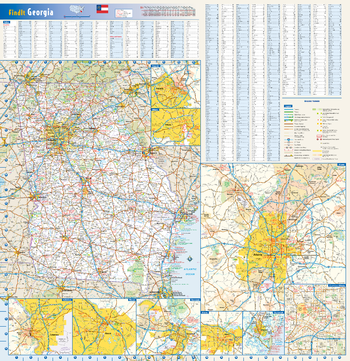
Georgia State Wall Map
This colorful, easy-to-read state map of Georgia identifies all major thoroughfares, secondary roads, freeway interchanges, rest areas, distance markers, landmarks, recreational areas, and more. Shaded relief on the state map provides a three-dimensional sense of Georgia's topography. Detailed inset maps of Albany, Athens, Atlanta, Augusta, Brunswick, Columbus, Macon, and Savannah are based on the latest street information from our cartographic experts. County and city indices make it simple to locate even the smallest town.
Page Size: 24 x 25 in (610 x 629 mm)
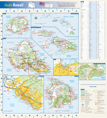
Hawaii State Wall Map
This colorful, easy-to-read state map of Hawaii identifies all major thoroughfares, secondary roads, freeway interchanges, rest areas, distance markers, landmarks, recreational areas, and more. Shaded relief on each island map provides a three-dimensional sense of Hawaii's topography. Detailed inset maps of Hilo and Honolulu are based on the latest street information from our cartographic experts. The map also includes an up-to-date inset of Hawaii Volcanoes National Park. County and city indices make it simple to locate even the smallest town.
Page Size: 16.5 x 18.25 in (419 x 464 mm)
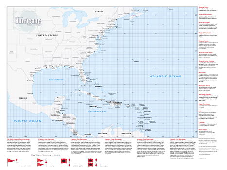
Hurricane Tracking Wall Map - Large
Perfect for home, business, school, or governmental emergency planning agency, this map of the central and western North Atlantic Ocean, Caribbean Sea, and Gulf of Mexico is divided into one degree latitude and longitude grid lines to make the tracking of tropical systems easy. The map includes a glossary of tropical meteorology terms and an explanation of the Saffir-Simpson Hurricane Wind Scale.
Page Size: 33 x 44 in (838 x 1118 mm)
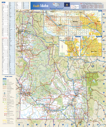
Idaho State Wall Map
This colorful, easy-to-read state map of Idaho identifies all major thoroughfares, secondary roads, freeway interchanges, rest areas, distance markers, landmarks, recreational areas, and more. Shaded relief on the state map provides a three-dimensional sense of Idaho’s topography. Detailed inset maps of Boise, Idaho Falls, and Pocatello are based on the latest street information from our cartographic experts. County and city indices make it simple to locate even the smallest town. City type sizes reflect the 2020 U.S. Census.
Page Size: 14.75 x 17.75 in (375 x 451 mm)
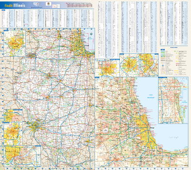
Illinois State Wall Map
This colorful, easy-to-read state map of Illinois identifies all major thoroughfares, secondary roads, freeway interchanges, rest areas, distance markers, landmarks, recreational areas, and more. Shaded relief on the state map provides a three-dimensional sense of Illinois' topography. Detailed city inset maps of Bloomington/Normal, Chicago, Champaign/Urbana, Decatur, Peoria, the Quad Cities, Rockford, and Springfield are based on the latest street information from our cartographic experts. An up-to-date inset of downtown Chicago provides must-see information on the central business and tourist district. County and city indices make it simple to locate even the smallest town.
Page Size: 27.75 x 25 in (705 x 629 mm)
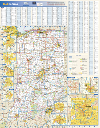
Indiana State Wall Map
This colorful, easy-to-read state map of Indiana identifies all major thoroughfares, secondary roads, freeway interchanges, rest areas, distance markers, landmarks, recreational areas, and more. Shaded relief on the state map provides a three-dimensional sense of Indiana's topography. Detailed city inset maps of Bloomington, Elkhart, Evansville, Fort Wayne, Indianapolis, Lafayette, Muncie, South Bend and Terre Haute are based on the latest street information from our cartographic experts. An inset of downtown Indianapolis provides must-see information on the central business district. County and city indices make it simple to locate even the smallest town.
Page Size: 20.5 x 26 in (521 x 660 mm)
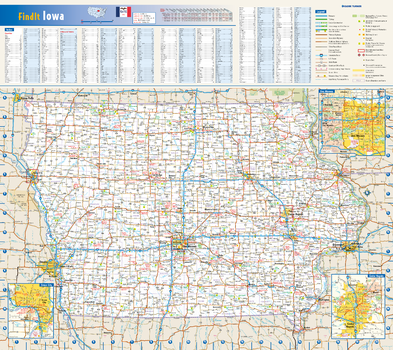
Iowa State Wall Map
This colorful, easy-to-read state map of Iowa identifies all major thoroughfares, secondary roads, freeway interchanges, rest areas, distance markers, landmarks, recreational areas, and more. Shaded relief on the state map provides a three-dimensional sense of Iowa's topography. Detailed inset maps of Cedar Rapids, Des Moines, and Sioux City are based on the latest street information from our cartographic experts. County and city indices make it simple to locate even the smallest town.
Page Size: 20.75 x 18.5 in (524 x 467 mm)
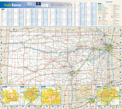
Kansas State Wall Map
This colorful, easy-to-read state map of Kansas identifies all major thoroughfares, secondary roads, freeway interchanges, rest areas, distance markers, landmarks, recreational areas, and more. Shaded relief on the state map provides a three-dimensional sense of Kansas' topography. Detailed inset maps of Lawrence, Manhattan, Topeka, and Wichita are based on the latest street information from our cartographic experts. County and city indices make it simple to locate even the smallest town.
Page Size: 20.75 x 18.5 in (524 x 467 mm)
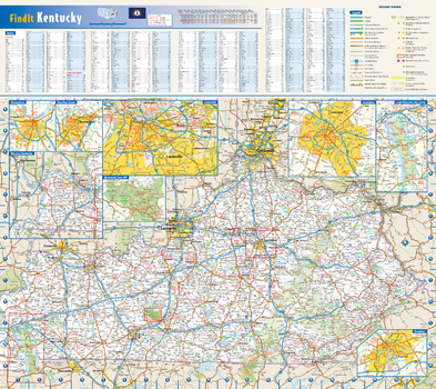
Kentucky State Wall Map
This colorful, easy-to-read state map of Kentucky identifies all major thoroughfares, secondary roads, freeway interchanges, rest areas, distance markers, landmarks, recreational areas, and more. Shaded relief on the state map provides a three-dimensional sense of Kentucky's topography. Detailed city inset maps of Bowling Green, Frankfort, Lexington, Louisville, and Owensboro are based on the latest street information from our cartographic experts. Up-to-date insets of Mammoth Cave National Park and Land Between the Lakes National Recreation Area provide must-see information on these tourist areas. County and city indices make it simple to locate even the smallest town.
Page Size: 20.75 x 18.5 in (524 x 467 mm)
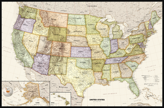
Legacy USA Wall Map
Perfect for home, business, or school, this Legacy USA Wall Map combines bright, attractive colors with high-detailed cartography in an antique style. Details on this United States Wall Map include: state boundaries and capitals along with other major cities and towns; major physical features such as mountain ranges and major mountain peaks; major water features such as oceans, seas, gulfs, and rivers; the Interstate highway system and other major roads; and all National Parks as well as other large National Park Service sites. Special features include ivory-colored oceans and a black decorative border. This map of the United States uses the Albers Equal Area projection.
Page Size: 50 x 33 in (1270 x 838 mm)
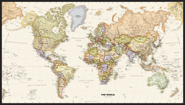
Legacy World Wall Map
Perfect for home, business, or school, this Legacy World Wall Map combines bright, attractive colors with high-detailed cartography in an antique style. Details on this World Wall Map include: international boundaries and national capitals along with other major cities; major physical features such as mountain ranges, major mountain peaks, island chains, and deserts; and major water features such as oceans, seas, gulfs, and rivers. Special features include ivory-colored oceans and a black decorative border. This map of the world uses the Van Der Grinten projection.
Page Size: 50 x 28.5 in (1270 x 724 mm)
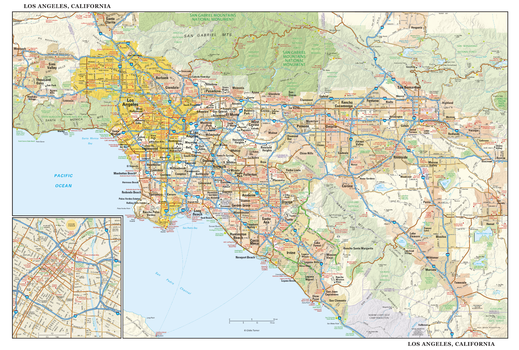
Los Angeles, California Wall Map, large
This detailed reference map combines two maps in one - a regional map of Los Angeles extending from Simi Valley and Santa Clarita to San Bernardino and San Clemente, plus a street-level inset map of downtown Los Angeles. The regional map depicts the area’s cities and towns, highways and roads, parks, lakes, and rivers, and a variety of major points of interest. Included on the regional L.A. map are well-known tourist areas such as Anaheim, Pasadena, Hollywood, Beverly Hills, and Santa Monica. The map is beautifully rendered with terrain relief. The inset map of central Los Angeles shows highways, streets, parks, landmarks, and other points of interest. Chinatown, Little Tokyo, the Arts District, South Park, and the Financial District are among the neighborhoods shown on this map. Also available in a large size of 14.50" high X 21.50" wide.
Page Size: 43 x 29 in (1092 x 737 mm)
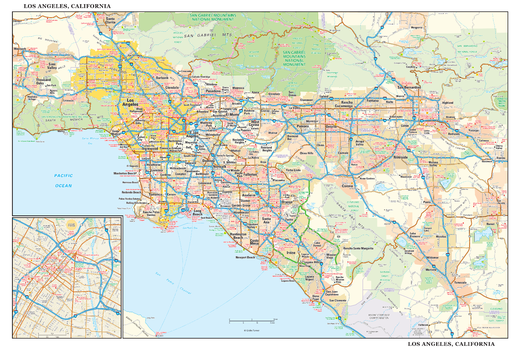
Los Angeles, California Wall Map, small
This detailed reference map combines two maps in one - a regional map of Los Angeles extending from Simi Valley and Santa Clarita to San Bernardino and San Clemente, plus a street-level inset map of downtown Los Angeles. The regional map depicts the area’s cities and towns, highways and roads, parks, lakes, and rivers, and a variety of major points of interest. Included on the regional L.A. map are well-known tourist areas such as Anaheim, Pasadena, Hollywood, Beverly Hills, and Santa Monica. The map is beautifully rendered with terrain relief. The inset map of central Los Angeles shows highways, streets, parks, landmarks, and other points of interest. Chinatown, Little Tokyo, the Arts District, South Park, and the Financial District are among the neighborhoods shown on this map. Also available in a large size of 29.00" high X 43.00" wide.
Page Size: 21.5 x 14.5 in (546 x 368 mm)
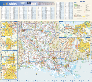
Louisiana State Wall Map
This colorful, easy-to-read state map of Louisiana identifies all major thoroughfares, secondary roads, freeway interchanges, rest areas, distance markers, landmarks, recreational areas, and more. Shaded relief on the state map provides a three-dimensional sense of Louisiana’s topography. Detailed city inset maps of Baton Rouge, Lafayette, Lake Charles, Monroe, and New Orleans are based on the latest street information from our cartographic experts. An up-to-date inset of the French Quarter and Central Business District provides must-see information on downtown New Orleans. County and city indices make it simple to locate even the smallest town. City type sizes reflect the 2020 U.S. Census.
Page Size: 20.75 x 18.5 in (524 x 467 mm)
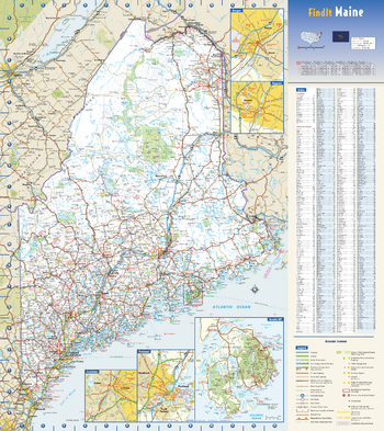
Maine State Wall Map
This colorful, easy-to-read state map of Maine identifies all major thoroughfares, secondary roads, freeway interchanges, rest areas, distance markers, landmarks, recreational areas, and more. Shaded relief on the state map provides a three-dimensional sense of Maine’s topography. Detailed city inset maps of Augusta, Bangor, Lewiston, and Portland are based on the latest street information from our cartographic experts. An up-to-date inset of Acadia National Park provides must-see information on this tourist area. County and city indices make it simple to locate even the smallest town.
Page Size: 18.5 x 20.75 in (467 x 524 mm)