Collins
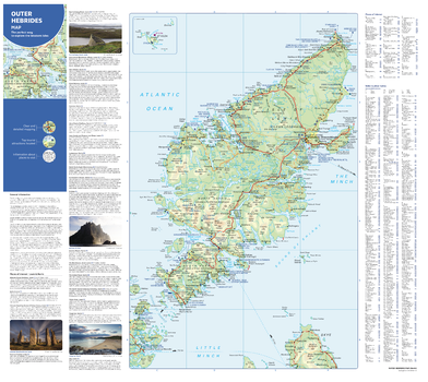
Collins Outer Hebrides Map - North
With clear mapping and a high level of detail, explore the Outer Hebrides easily with maps from Collins. The islands covered are Lewis, Harris, Uist, Benbecula, Bara and St Kilda. An ideal guide for tourists and residents alike, this map identifies many tourist attractions, places to stay, cafes, restaurants and transport links. This is an essential companion or souvenir for anyone visiting the Scotland’s Western Isles.
Page Size: 25 x 22.25 in (630 x 560 mm)
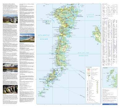
Collins Outer Hebrides Map - South
With clear mapping and a high level of detail, explore the Outer Hebrides easily with maps from Collins. The islands covered are Lewis, Harris, Uist, Benbecula, Bara and St Kilda. An ideal guide for tourists and residents alike, this map identifies many tourist attractions, places to stay, cafes, restaurants and transport links. This is an essential companion or souvenir for anyone visiting the Scotland’s Western Isles.
Page Size: 25 x 22.25 in (630 x 560 mm)
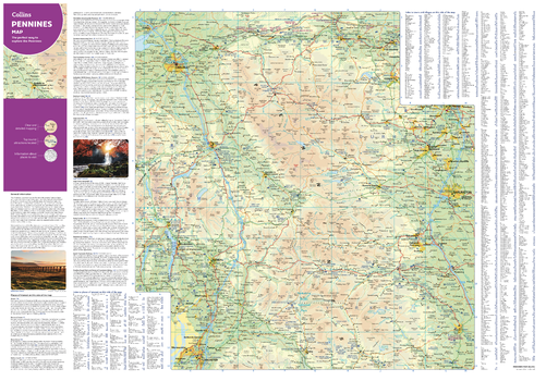
Collins Pennines Map - North
With clear mapping and a high level of detail, explore the north Pennines easily with maps from Collins. An ideal guide for tourists and residents alike, this map identifies many tourist attractions, places to stay, and cafes and restaurants. An essential map for any visitors planning a trip to the Pennines.
Page Size: 32 x 22.25 in (810 x 560 mm)
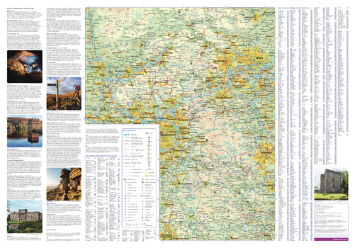
Collins Pennines Map - South
With clear mapping and a high level of detail, explore the south Pennines easily with maps from Collins. An ideal guide for tourists and residents alike, this map identifies many tourist attractions, places to stay, and cafes and restaurants. An essential map for any visitors planning a trip to the Pennines.
Page Size: 32 x 22.25 in (810 x 560 mm)
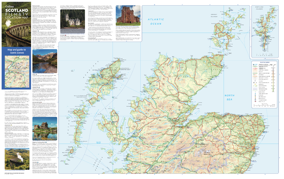
Collins Scotland Film and TV Map - North
With clear mapping and a high level of detail, explore the most popular filming locations in northern Scotland with maps from Collins. An ideal guide for tourists and locals alike, this map reveals the locations behind some of the most iconic scenes in Hollywood and Bollywood. From Winterfell to Skyfall, Hogwarts to Lallybroch, this map is the ideal companion for anyone planning an unforgettable trip to Scotland.
Page Size: 35.5 x 22.25 in (900 x 560 mm)
Collins Scotland Film and TV Map - South
With clear mapping and a high level of detail, explore the most popular filming locations in southern Scotland with maps from Collins. An ideal guide for tourists and locals alike, this map reveals the locations behind some of the most iconic scenes in Hollywood and Bollywood. From Winterfell to Skyfall, Hogwarts to Lallybroch, this map is the ideal companion for anyone planning an unforgettable trip to Scotland.
Page Size: 35.5 x 22.25 in (900 x 560 mm)
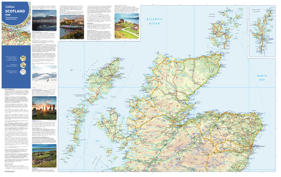
Collins Scotland Map - North
Full colour map of Northern Scotland. Detailed mapping of the Highlands, Moray, Aberdeenshire, Outer Hebrides, Orkney and Shetland Islands. Includes photographs and further information for selected places of interest.
Page Size: 35.5 x 22.25 in (900 x 560 mm)
Collins Scotland Map - South
Full colour map of Southern Scotland. Detailed mapping of the Central Belt, Argyll & Bute, Ayrshire, Dumfries & Galloway, Scottish Borders, Stirling, Perth & Kinross and Angus. Includes photographs and further information for selected places of interest.
Page Size: 35.5 x 22.25 in (900 x 560 mm)
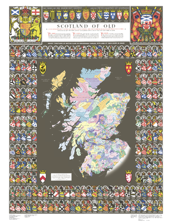
Collins Scotland of Old Map
The Collins Scotland of Old Clans Map is a unique pictorial map showing the ancient territories of the principal Scottish clans in the 17th century, and features Don Pottinger’s (Islay Herald of Arms) distinctive and original artwork of Scottish arms and crest badges.
The map includes:
- Over 170 arms, the official insignia of clan chiefs, and crest badges
- Territories map of principal clans at the beginning of the 17th century
- Arms of the ancient Scottish principalities
- Locations of the ancient territories held by the clans around the time of King James VI
The map is ideal for those those with an interest in Scottish heraldry, clans and family history. The map is based on the map originally conceived and illustrated by the late Sir Iain Moncreiffe of that Ilk, Bart., C.V.O., Q.C., Ph.D., Albany Herald of Arms, and the late Don Pottinger, C.V.O., M.A., D.A., Islay Herald of Arms.
Page Size: 30.75 x 40 in (775 x 1015 mm)
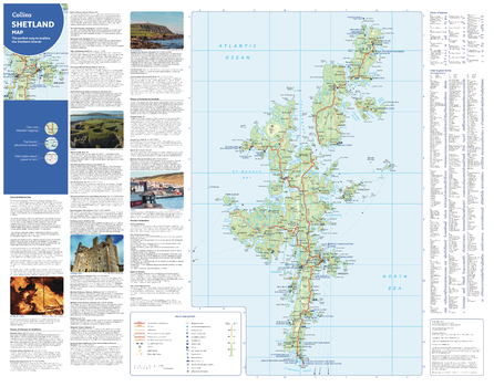
Collins Shetland Map
With clear mapping and a high level of detail, explore Shetland easily with maps from Collins. This map identifies tourist attractions and places to stay, as well as restaurants and tourist information sites, making it an essential map for any visitors or residents exploring the Shetland Islands.
Page Size: 28.5 x 22.25 in (720 x 560 mm)
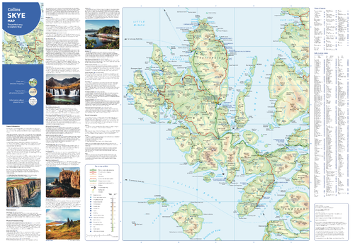
Collins Skye Map
With clear mapping and a high level of detail, explore the Isle of Skye easily with maps from Collins. This map identifies tourist attractions, caravan and camping sites, as well as restaurants and tourist information sites, making it an essential map for any visitors or residents exploring the ‘Misty Isle’.
Page Size: 32 x 22.25 in (810 x 560 mm)
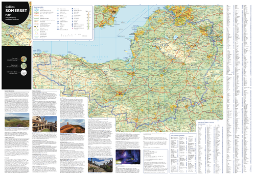
Collins Somerset Map
With clear mapping and a high level of detail, explore Somerset easily with maps from Collins. An ideal guide for tourists and locals alike, this map identifies tourist attractions, places to stay, cafes, and restaurants. An essential companion or souvenir for anyone visiting South West England.
Page Size: 32 x 22.25 in (810 x 560 mm)
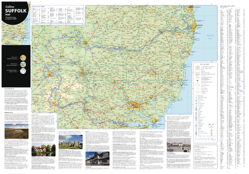
Collins Suffolk Map
With clear mapping and a high level of detail, explore Suffolk easily with maps from Collins. An ideal guide for tourists and residents alike, this map identifies many tourist attractions, places to stay, cafes and restaurants. This is an essential map for anyone exploring Suffolk.
Page Size: 32 x 22.25 in (810 x 560 mm)
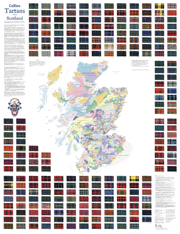
Collins Tartans Map of Scotland
Scotland’s clans, tartans and family names shown on a large map of Scotland – officially approved by the Scottish Tartans Authority. This beautifully illustrated map is both decorative and informative.
The map includes:
- 247 tartans with clan/family names, alphabetically arranged for easy look-up, from Abercromby to Young.
- Territories map of principal clans at the beginning of the 17th century.
- Historical background to clans and tartans.
- Internet links for more information.
Page Size: 30.75 x 40 in (775 x 1015 mm)
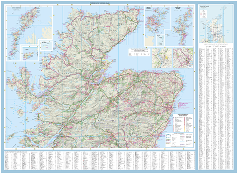
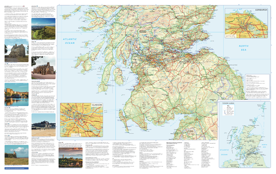
Collins Touring Map of Scotland - North
With clear mapping and a high level of detail, explore Scotland easily with maps from Collins. An ideal guide for tourists and residents alike, this map extends from Northern England in the south to Orkney and the Shetland Islands in the north, identifying more than 1000 tourist attractions, places to stay, cafes, and restaurants. It also includes detailed town centre maps of Edinburgh, Glasgow, Aberdeen, Dundee, Inverness, and Perth. An essential map for any visitors to Scotland.
Page Size: 49.75 x 36.25 in (1260 x 915 mm)
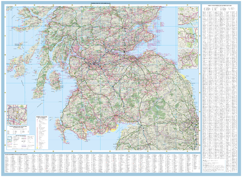
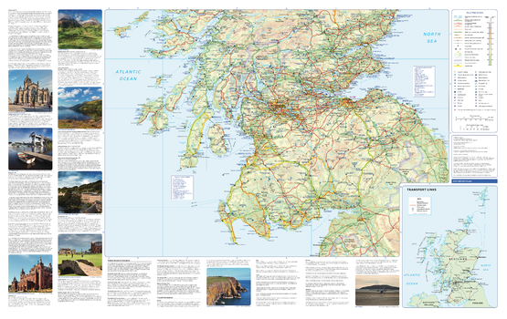
Collins Touring Map of Scotland - South
With clear mapping and a high level of detail, explore Scotland easily with maps from Collins. An ideal guide for tourists and residents alike, this map extends from Northern England in the south to Orkney and the Shetland Islands in the north, identifying more than 1000 tourist attractions, places to stay, cafes, and restaurants. It also includes detailed town centre maps of Edinburgh, Glasgow, Aberdeen, Dundee, Inverness, and Perth. An essential map for any visitors to Scotland.
Page Size: 49.75 x 36.25 in (1260 x 915 mm)
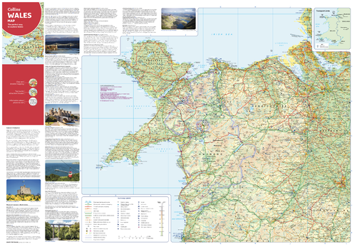
Collins Wales Map - North
With clear mapping and a high level of detail, explore North Wales easily with maps from Collins. An ideal guide for tourists and locals alike, this map identifies local attractions, places to stay, cafes, and restaurants. An essential companion or souvenir for anyone visiting Cymru.
Page Size: 32 x 22.25 in (810 x 560 mm)
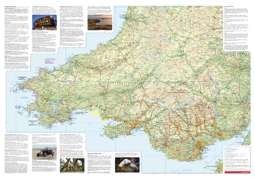
Collins Wales Map - South
With clear mapping and a high level of detail, explore South Wales easily with maps from Collins. An ideal guide for tourists and locals alike, this map identifies local attractions, places to stay, cafes, and restaurants. An essential companion or souvenir for anyone visiting Cymru.
Page Size: 32 x 22.25 in (810 x 560 mm)
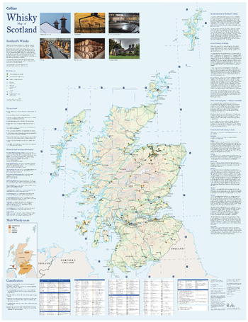
Collins Whisky Map of Scotland
Discover where Scotland’s national drink is produced. All of Scotland’s operational whisky distilleries and whisky-related places of interest, located on one map. Also includes an easy-to-use index listing visitor facilities, contact details and websites.
The map includes:
- Over 100 distilleries and whisky-related places of interest
- Insert map of malt whisky areas
- A photographic guide to how whisky is made
- Selection of labels of blended Scotch whisky brands
- Did you know? section with interesting facts
- World maps of main export markets
- Index lists visitor facilities, telephone numbers and websites
Page Size: 30.75 x 40 in (775 x 1015 mm)
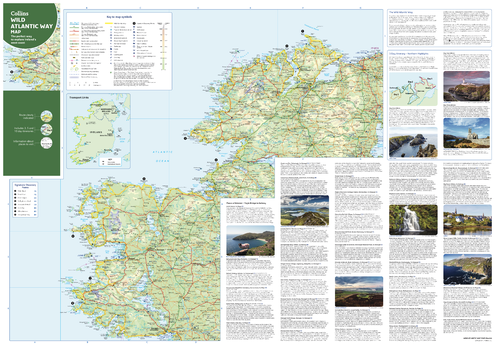
Collins Wild Atlantic Way Map - North
With clear mapping and a high level of detail, explore Ireland’s Wild Atlantic Way easily with maps from Collins. An ideal guide for tourists, locals, hikers and adventurers, this map covers the full 2500 km route (over 1500 miles), identifying tourist attractions, filming locations, places to stay, cafes, and restaurants. An essential companion or souvenir for anyone travelling along the Wild Atlantic Way.
Page Size: 32 x 22.25 in (810 x 560 mm)