


Backroad Mapbooks
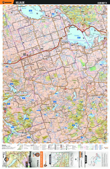
CCON74 Killaloe - Cottage Country Ontario Topo
This recreation topographic map for Killaloe highlights all the logging/resource roads, hunting areas, fishing lakes & streams, campsites, paddling routes for canoeing and kayaking, wildlife viewing areas, multi-use trails for hiking, biking, horseback riding, cross-country skiing and snowshoeing, motorized trails for ATVing and snowmobiling & more. Covering 1,090 km2 (420 mi2), this 1:50,000 scale map measures 29 x 38 km (18 x 24 mi), providing you with more topographic and recreational detail for the Richmond Hill area than any other map on the market. New features include enhanced Crown land, countless new roads and trails and a wealth of recreational Points of Interest. Included on this map are Killaloe, Deacon, Round Lake, Golden Lake, Madawaska, Hopefield, Brudenell and more!
Page Size: 24 x 37 in (610 x 940 mm)
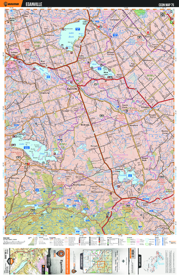
CCON75 Eganville - Cottage Country Ontario Topo
This recreation topographic map for Eganville highlights all the logging/resource roads, hunting areas, fishing lakes & streams, campsites, paddling routes for canoeing and kayaking, wildlife viewing areas, multi-use trails for hiking, biking, horseback riding, cross-country skiing and snowshoeing, motorized trails for ATVing and snowmobiling & more. Covering 1,090 km2 (420 mi2), this 1:50,000 scale map measures 29 x 38 km (18 x 24 mi), providing you with more topographic and recreational detail for the Richmond Hill area than any other map on the market. New features include enhanced Crown land, countless new roads and trails and a wealth of recreational Points of Interest. Included on this map are Eganville, McGrath, Wolftown, Mink Lake, Lake Clear, Constant Lake, Pine Valley and more!
Page Size: 24 x 37 in (610 x 940 mm)
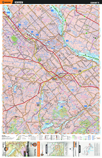
CCON76 Renfrew - Cottage Country Ontario Topo
This recreation topographic map for Renfrew highlights all the logging/resource roads, hunting areas, fishing lakes & streams, campsites, paddling routes for canoeing and kayaking, wildlife viewing areas, multi-use trails for hiking, biking, horseback riding, cross-country skiing and snowshoeing, motorized trails for ATVing and snowmobiling & more. Covering 1,090 km2 (420 mi2), this 1:50,000 scale map measures 29 x 38 km (18 x 24 mi), providing you with more topographic and recreational detail for the Richmond Hill area than any other map on the market. New features include enhanced Crown land, countless new roads and trails and a wealth of recreational Points of Interest. Included on this map are Renfrew, Cobden, Ferguson's Beach, Mayhew, Haley Station, Burnstown and more!
Page Size: 24 x 37 in (610 x 940 mm)
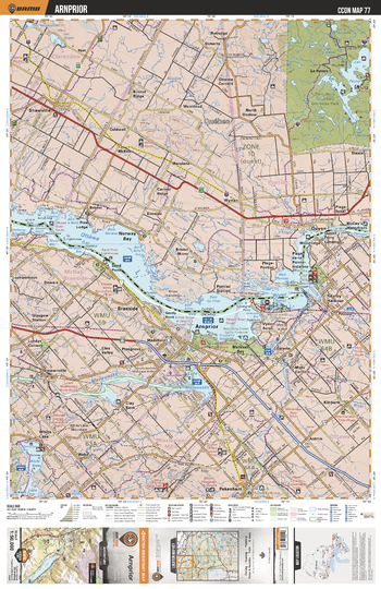
CCON77 Arnprior - Cottage Country Ontario Topo
This recreation topographic map for Arnprior highlights all the logging/resource roads, hunting areas, fishing lakes & streams, campsites, paddling routes for canoeing and kayaking, wildlife viewing areas, multi-use trails for hiking, biking, horseback riding, cross-country skiing and snowshoeing, motorized trails for ATVing and snowmobiling & more. Covering 1,090 km2 (420 mi2), this 1:50,000 scale map measures 29 x 38 km (18 x 24 mi), providing you with more topographic and recreational detail for the Richmond Hill area than any other map on the market. New features include enhanced Crown land, countless new roads and trails and a wealth of recreational Points of Interest. Included on this map are Arnprior, Braeside, Kinburn, Stewartville, Ottawa River, Fitzroy Harbour and more!
Page Size: 24 x 37 in (610 x 940 mm)
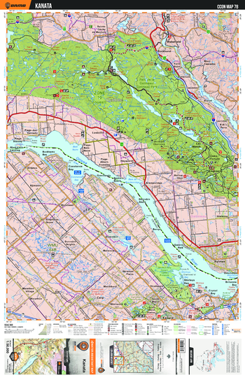
CCON78 Kanata - Cottage Country Ontario Topo
This recreation topographic map for Kanata highlights all the logging/resource roads, hunting areas, fishing lakes & streams, campsites, paddling routes for canoeing and kayaking, wildlife viewing areas, multi-use trails for hiking, biking, horseback riding, cross-country skiing and snowshoeing, motorized trails for ATVing and snowmobiling & more. Covering 1,090 km2 (420 mi2), this 1:50,000 scale map measures 29 x 38 km (18 x 24 mi), providing you with more topographic and recreational detail for the Richmond Hill area than any other map on the market. New features include enhanced Crown land, countless new roads and trails and a wealth of recreational Points of Interest. Included on this map are Kanata, Bay, Strathearn, Malwood, Woodlawn, Dirleton and more!
Page Size: 24 x 37 in (610 x 940 mm)
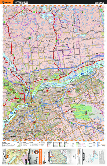
CCON79 Ottawa Hull - Cottage Country Ontario Topo
This recreation topographic map for Ottawa and Hull highlights all the logging/resource roads, hunting areas, fishing lakes & streams, campsites, paddling routes for canoeing and kayaking, wildlife viewing areas, multi-use trails for hiking, biking, horseback riding, cross-country skiing and snowshoeing, motorized trails for ATVing and snowmobiling & more. Covering 1,090 km2 (420 mi2), this 1:50,000 scale map measures 29 x 38 km (18 x 24 mi), providing you with more topographic and recreational detail for the Richmond Hill area than any other map on the market. New features include enhanced Crown land, countless new roads and trails and a wealth of recreational Points of Interest. Included on this map are Ottawa Hull, Ottawa, Blossom Park, Nepean, Orleans, Blackburn and more!
Page Size: 24 x 37 in (610 x 940 mm)
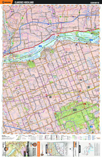
CCON80 Clarence-Rockland - Cottage Country Ontario Topo
This recreation topographic map for Clarence and Rockland highlights all the logging/resource roads, hunting areas, fishing lakes & streams, campsites, paddling routes for canoeing and kayaking, wildlife viewing areas, multi-use trails for hiking, biking, horseback riding, cross-country skiing and snowshoeing, motorized trails for ATVing and snowmobiling & more. Covering 1,090 km2 (420 mi2), this 1:50,000 scale map measures 29 x 38 km (18 x 24 mi), providing you with more topographic and recreational detail for the Richmond Hill area than any other map on the market. New features include enhanced Crown land, countless new roads and trails and a wealth of recreational Points of Interest. Included on this map are Rockland, Clarence, Cheney, Navan, Orient, Vars, Sarsfield and more!
Page Size: 24 x 37 in (610 x 940 mm)
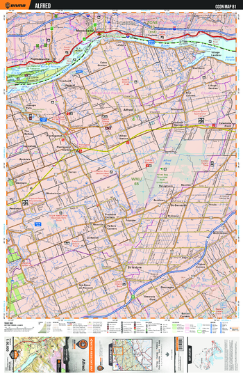
CCON81 Alfred - Cottage Country Ontario Topo
This recreation topographic map for Alfred highlights all the logging/resource roads, hunting areas, fishing lakes & streams, campsites, paddling routes for canoeing and kayaking, wildlife viewing areas, multi-use trails for hiking, biking, horseback riding, cross-country skiing and snowshoeing, motorized trails for ATVing and snowmobiling & more. Covering 1,090 km2 (420 mi2), this 1:50,000 scale map measures 29 x 38 km (18 x 24 mi), providing you with more topographic and recreational detail for the Richmond Hill area than any other map on the market. New features include enhanced Crown land, countless new roads and trails and a wealth of recreational Points of Interest. Included on this map are Alfred, Westminster, La Nation, Evanturel, Plantagenet, Glenburn, Rockdale and more!
Page Size: 24 x 37 in (610 x 940 mm)
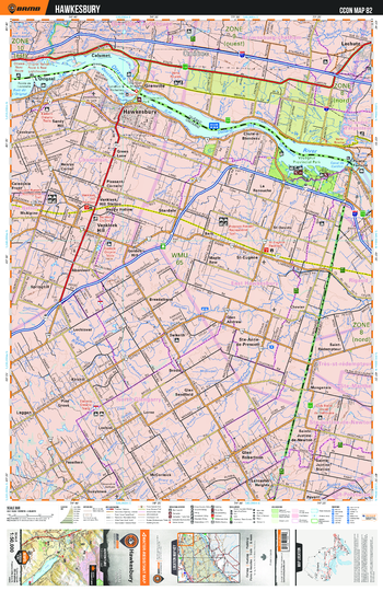
CCON82 Hawkesbury - Cottage Country Ontario Topo
This recreation topographic map for Hawkesbury highlights all the logging/resource roads, hunting areas, fishing lakes & streams, campsites, paddling routes for canoeing and kayaking, wildlife viewing areas, multi-use trails for hiking, biking, horseback riding, cross-country skiing and snowshoeing, motorized trails for ATVing and snowmobiling & more. Covering 1,090 km2 (420 mi2), this 1:50,000 scale map measures 29 x 38 km (18 x 24 mi), providing you with more topographic and recreational detail for the Richmond Hill area than any other map on the market. New features include enhanced Crown land, countless new roads and trails and a wealth of recreational Points of Interest. Included on this map are Hawkesbury, Vankleek Hill, L'Orignal, Glen Sandfield, La Renouche, Kirkhill and more!
Page Size: 24 x 37 in (610 x 940 mm)
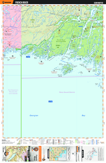
CCON83 French River - Cottage Country Ontario Topo
This recreation topographic map for French River highlights all the logging/resource roads, hunting areas, fishing lakes & streams, campsites, paddling routes for canoeing and kayaking, wildlife viewing areas, multi-use trails for hiking, biking, horseback riding, cross-country skiing and snowshoeing, motorized trails for ATVing and snowmobiling & more. Covering 1,090 km2 (420 mi2), this 1:50,000 scale map measures 29 x 38 km (18 x 24 mi), providing you with more topographic and recreational detail for the Richmond Hill area than any other map on the market. New features include enhanced Crown land, countless new roads and trails and a wealth of recreational Points of Interest. Included on this map are French River, Provincial, Georgian Bay, Wanapitei, Island, River and more!
Page Size: 24 x 37 in (610 x 940 mm)
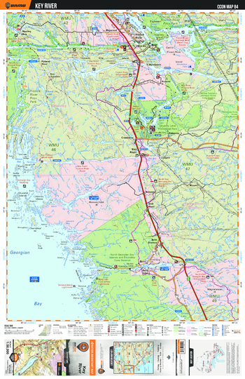
CCON84 Key River - Cottage Country Ontario Topo
This recreation topographic map for Key River highlights all the logging/resource roads, hunting areas, fishing lakes & streams, campsites, paddling routes for canoeing and kayaking, wildlife viewing areas, multi-use trails for hiking, biking, horseback riding, cross-country skiing and snowshoeing, motorized trails for ATVing and snowmobiling & more. Covering 1,090 km2 (420 mi2), this 1:50,000 scale map measures 29 x 38 km (18 x 24 mi), providing you with more topographic and recreational detail for the Richmond Hill area than any other map on the market. New features include enhanced Crown land, countless new roads and trails and a wealth of recreational Points of Interest. Included on this map are Cranberry, Britt Station, Byng Inlet, Ludgate, French River, Pakesley, Provincial and more!
Page Size: 24 x 37 in (610 x 940 mm)
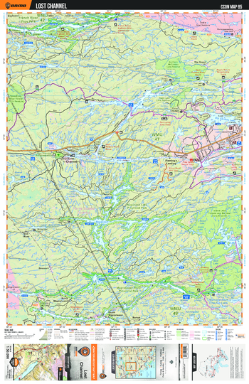
CCON85 Lost Channel - Cottage Country Ontario Topo
This recreation topographic map for Lost Channel highlights all the logging/resource roads, hunting areas, fishing lakes & streams, campsites, paddling routes for canoeing and kayaking, wildlife viewing areas, multi-use trails for hiking, biking, horseback riding, cross-country skiing and snowshoeing, motorized trails for ATVing and snowmobiling & more. Covering 1,090 km2 (420 mi2), this 1:50,000 scale map measures 29 x 38 km (18 x 24 mi), providing you with more topographic and recreational detail for the Richmond Hill area than any other map on the market. New features include enhanced Crown land, countless new roads and trails and a wealth of recreational Points of Interest. Included on this map are Lost Channel, Noganosh Lake Provincial Park, Fleming's Landing, Magnetawan, Still River, Drocourt, The Depot and more!
Page Size: 24 x 37 in (610 x 940 mm)
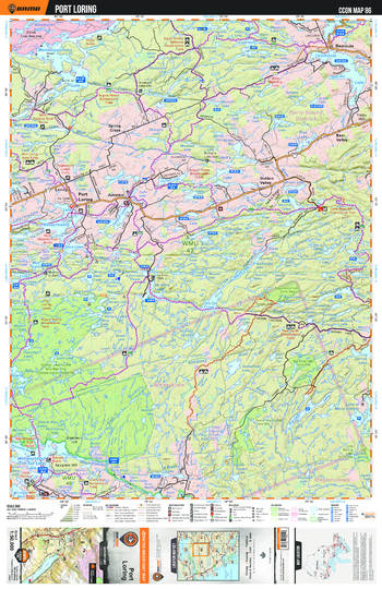
CCON86 Port Loring - Cottage Country Ontario Topo
This recreation topographic map for Port Loring highlights all the logging/resource roads, hunting areas, fishing lakes & streams, campsites, paddling routes for canoeing and kayaking, wildlife viewing areas, multi-use trails for hiking, biking, horseback riding, cross-country skiing and snowshoeing, motorized trails for ATVing and snowmobiling & more. Covering 1,090 km2 (420 mi2), this 1:50,000 scale map measures 29 x 38 km (18 x 24 mi), providing you with more topographic and recreational detail for the Richmond Hill area than any other map on the market. New features include enhanced Crown land, countless new roads and trails and a wealth of recreational Points of Interest. Included on this map are Port Loring, Golden Valley, Bear Valley, Spring Creek, Arnstein, Restoule and more!
Page Size: 24 x 37 in (610 x 940 mm)
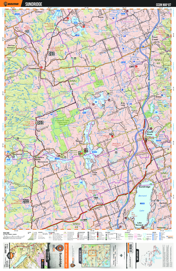
CCON87 Sundridge - Cottage Country Ontario Topo
This recreation topographic map for Sundridge highlights all the logging/resource roads, hunting areas, fishing lakes & streams, campsites, paddling routes for canoeing and kayaking, wildlife viewing areas, multi-use trails for hiking, biking, horseback riding, cross-country skiing and snowshoeing, motorized trails for ATVing and snowmobiling & more. Covering 1,090 km2 (420 mi2), this 1:50,000 scale map measures 29 x 38 km (18 x 24 mi), providing you with more topographic and recreational detail for the Richmond Hill area than any other map on the market. New features include enhanced Crown land, countless new roads and trails and a wealth of recreational Points of Interest. Included on this map are Sundridge, Stewart Bay, Deans, Farleys Corners, Lake Bernard, Trout Creek, Trans Canada Trail and more!
Page Size: 24 x 37 in (610 x 940 mm)
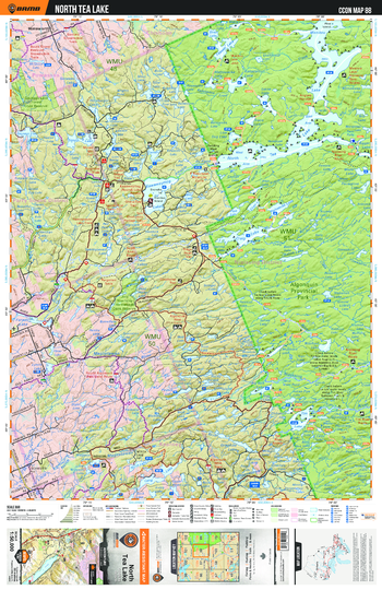
CCON88 North Tea Lake - Cottage Country Ontario Topo
This recreation topographic map for North Tea Lake highlights all the logging/resource roads, hunting areas, fishing lakes & streams, campsites, paddling routes for canoeing and kayaking, wildlife viewing areas, multi-use trails for hiking, biking, horseback riding, cross-country skiing and snowshoeing, motorized trails for ATVing and snowmobiling & more. Covering 1,090 km2 (420 mi2), this 1:50,000 scale map measures 29 x 38 km (18 x 24 mi), providing you with more topographic and recreational detail for the Richmond Hill area than any other map on the market. New features include enhanced Crown land, countless new roads and trails and a wealth of recreational Points of Interest. Included on this map are North Tea Lake, Algonquin Provincial Park, Trail, Sausage Lake Forest, Magnetawan River, Manitou Lake and more!
Page Size: 24 x 37 in (610 x 940 mm)
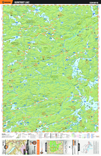
CCON89 Burntroot Lake - Cottage Country Ontario Topo
This recreation topographic map for Burntoot Lake highlights all the logging/resource roads, hunting areas, fishing lakes & streams, campsites, paddling routes for canoeing and kayaking, wildlife viewing areas, multi-use trails for hiking, biking, horseback riding, cross-country skiing and snowshoeing, motorized trails for ATVing and snowmobiling & more. Covering 1,090 km2 (420 mi2), this 1:50,000 scale map measures 29 x 38 km (18 x 24 mi), providing you with more topographic and recreational detail for the Richmond Hill area than any other map on the market. New features include enhanced Crown land, countless new roads and trails and a wealth of recreational Points of Interest. Included on this map are Burntroot Lake, Algonquin Provincial Park, Big Trout Lake, Biggar Lake, Carl Wilson Lake, Gibson Lake and more!
Page Size: 24 x 37 in (610 x 940 mm)
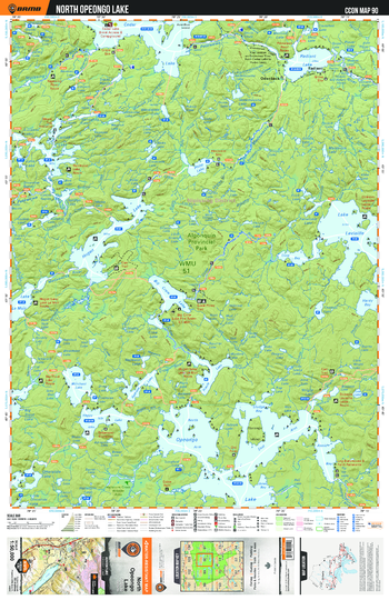
CCON90 North Opeongo Lake - Cottage Country Ontario Topo
This recreation topographic map for North Opeongo Lake highlights all the logging/resource roads, hunting areas, fishing lakes & streams, campsites, paddling routes for canoeing and kayaking, wildlife viewing areas, multi-use trails for hiking, biking, horseback riding, cross-country skiing and snowshoeing, motorized trails for ATVing and snowmobiling & more. Covering 1,090 km2 (420 mi2), this 1:50,000 scale map measures 29 x 38 km (18 x 24 mi), providing you with more topographic and recreational detail for the Richmond Hill area than any other map on the market. New features include enhanced Crown land, countless new roads and trails and a wealth of recreational Points of Interest. Included on this map are North Opeongo Lake, Algonquin Provincial Park, Radiant Lake, Merchant Lake, Happy Isle Lake, Hogan Lake and more!
Page Size: 24 x 37 in (610 x 940 mm)
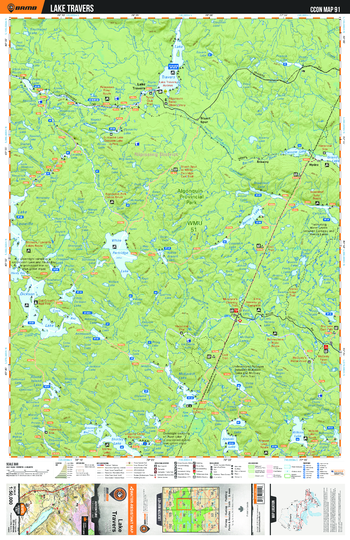
CCON91 Lake Travers - Cottage Country Ontario Topo
This recreation topographic map for Lake Travers highlights all the logging/resource roads, hunting areas, fishing lakes & streams, campsites, paddling routes for canoeing and kayaking, wildlife viewing areas, multi-use trails for hiking, biking, horseback riding, cross-country skiing and snowshoeing, motorized trails for ATVing and snowmobiling & more. Covering 1,090 km2 (420 mi2), this 1:50,000 scale map measures 29 x 38 km (18 x 24 mi), providing you with more topographic and recreational detail for the Richmond Hill area than any other map on the market. New features include enhanced Crown land, countless new roads and trails and a wealth of recreational Points of Interest. Included on this map are Lake Travers, Algonquin Provincial Park, Brawny, Stuart Spur, Hydro, White Partridge Lake and more!
Page Size: 24 x 37 in (610 x 940 mm)
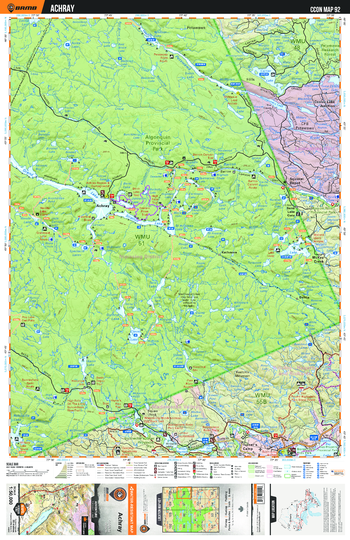
CCON92 Achray - Cottage Country Ontario Topo
This recreation topographic map for Achray highlights all the logging/resource roads, hunting areas, fishing lakes & streams, campsites, paddling routes for canoeing and kayaking, wildlife viewing areas, multi-use trails for hiking, biking, horseback riding, cross-country skiing and snowshoeing, motorized trails for ATVing and snowmobiling & more. Covering 1,090 km2 (420 mi2), this 1:50,000 scale map measures 29 x 38 km (18 x 24 mi), providing you with more topographic and recreational detail for the Richmond Hill area than any other map on the market. New features include enhanced Crown land, countless new roads and trails and a wealth of recreational Points of Interest. Included on this map are Achray, Algonquin Provincial Park, Dahlia, Basin Depot, Trail, Turner's Camp and more!
Page Size: 24 x 37 in (610 x 940 mm)
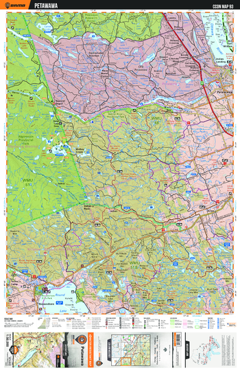
CCON93 Petawawa - Cottage Country Ontario Topo
This recreation topographic map for Petawawa highlights all the logging/resource roads, hunting areas, fishing lakes & streams, campsites, paddling routes for canoeing and kayaking, wildlife viewing areas, multi-use trails for hiking, biking, horseback riding, cross-country skiing and snowshoeing, motorized trails for ATVing and snowmobiling & more. Covering 1,090 km2 (420 mi2), this 1:50,000 scale map measures 29 x 38 km (18 x 24 mi), providing you with more topographic and recreational detail for the Richmond Hill area than any other map on the market. New features include enhanced Crown land, countless new roads and trails and a wealth of recreational Points of Interest. Included on this map are Petawawa, Indian River, Algonquin Provincial Park, McKay Creek, Bonnechere, Black Bay and more!
Page Size: 24 x 37 in (610 x 940 mm)