Backroad Mapbooks
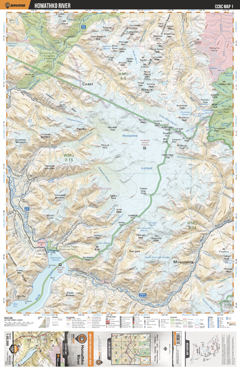
CCBC01 Homathko River - Cariboo Chilcotin Coast BC Topo
This recreation topographic map for the Homathko River area highlights all the logging roads, trails and recreational Points of Interest including hunting, camping, hiking, mountain biking, canoeing, kayaking, backcountry skiing, wildlife viewing, ATVing, snowmobiling and more. No other map provides you with this level of recreational and topographic detail for the Homathko River area. Covering the Homathko Icefield, Homathko River, Ts'yl-Os Prov Park, Bute Inlet, Homathko River Tatlayoko Protected Area, Bishop River, Southgate River, Jewakwa River, Staonsayako River and more, this map contains new features such as private land and labelled fish species. The 1:85,000 scale map covers 3,040 km2 (1,175 mi2), measuring 50 x 63.5 km (30 x 39.5 mi).
Page Size: 24 x 37 in (610 x 940 mm)
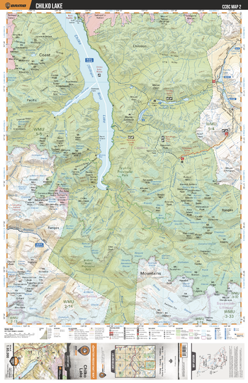
CCBC02 Chilko Lake - Cariboo Chilcotin Coast BC Topo
This recreation topographic map for the Chilko Lake area highlights all the logging roads, trails and recreational Points of Interest including hunting, camping, hiking, mountain biking, canoeing, kayaking, backcountry skiing, wildlife viewing, ATVing, snowmobiling and more. No other map provides you with this level of recreational and topographic detail for the Homathko River area. Covering the Chilko Lake, Yohetta Lake, Ts'yl-Os Prov Park, Tchaikazan River, Tuzcha Lake, Fishem Lake, Dorothy Lake, Chilko Mtn, Bishop River Prov Park and more, this map contains new features such as private land and labelled fish species. The 1:85,000 scale map covers 3,040 km2 (1,175 mi2), measuring 50 x 63.5 km (30 x 39.5 mi).
Page Size: 24 x 37 in (610 x 940 mm)

CCBC03 South Chilcotin Provincial Park - Cariboo Chilcotin Coast BC Topo
This recreation topographic map for the South Chilcotin Provincial Park area highlights all the logging roads, trails and recreational Points of Interest including hunting, camping, hiking, mountain biking, canoeing, kayaking, backcountry skiing, wildlife viewing, ATVing, snowmobiling and more. No other map provides you with this level of recreational and topographic detail for the Homathko River area. Covering the South Chilcotin Prov Park, Big Creek Prov Park, Summit Lakes, Bridge River, Slim Creek, Spruce Lake, Taseko River, Ts'yl-Os Prov Park, Lower Taseko Lake, Upper Taseko Lake and more, this map contains new features such as private land and labelled fish species. The 1:85,000 scale map covers 3,040 km2 (1,175 mi2), measuring 50 x 63.5 km (30 x 39.5 mi).
Page Size: 24 x 37 in (610 x 940 mm)
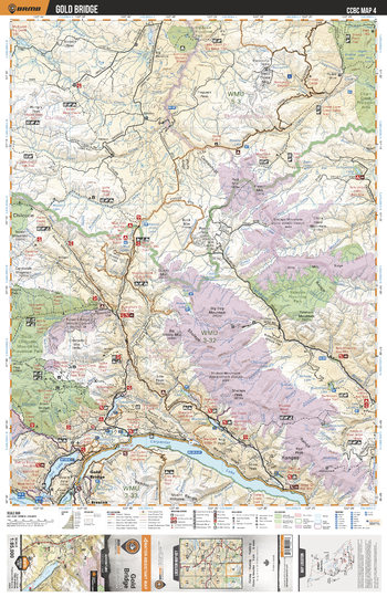
CCBC04 Gold Bridge - Cariboo Chilcotin Coast BC Topo
This recreation topographic map for the Gold Bridge area highlights all the logging roads, trails and recreational Points of Interest including hunting, camping, hiking, mountain biking, canoeing, kayaking, backcountry skiing, wildlife viewing, ATVing, snowmobiling and more. No other map provides you with this level of recreational and topographic detail for the Homathko River area. Covering the South Chilcotin Prov Park, Carpenter Lake, Gun Lake, Nine Mile Ridge, Yalakom River, Churn Creek Protected Area, Tyaughton Lake, Mud Lakes, Red Mtn, Gold Bridge and more, this map contains new features such as private land and labelled fish species. The 1:85,000 scale map covers 3,040 km2 (1,175 mi2), measuring 50 x 63.5 km (30 x 39.5 mi).
Page Size: 24 x 37 in (610 x 940 mm)
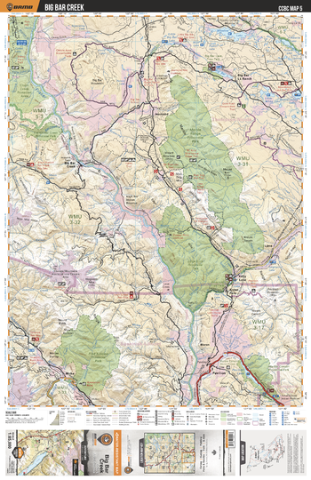
CCBC05 Big Bar Creek - Cariboo Chilcotin Coast BC Topo
This recreation topographic map for the Big Bar Creek area highlights all the logging roads, trails and recreational Points of Interest including hunting, camping, hiking, mountain biking, canoeing, kayaking, backcountry skiing, wildlife viewing, ATVing, snowmobiling and more. No other map provides you with this level of recreational and topographic detail for the Homathko River area. Covering the Big Bar Creek, Moha, Pavilion, Big Bar Lake Ranch, Jesmond, Marble Range Prov Park, Edge Hills Prov Park, Churn Creek Protected Area, Hogback Mtn, Fraser River and more, this map contains new features such as private land and labelled fish species. The 1:85,000 scale map covers 3,040 km2 (1,175 mi2), measuring 50 x 63.5 km (30 x 39.5 mi).
Page Size: 24 x 37 in (610 x 940 mm)
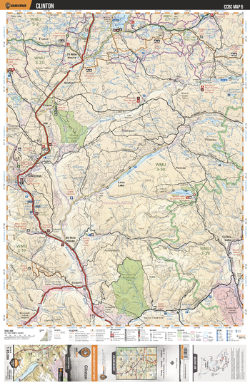
CCBC06 Clinton - Cariboo Chilcotin Coast BC Topo
This recreation topographic map for the Clinton area highlights all the logging roads, trails and recreational Points of Interest including hunting, camping, hiking, mountain biking, canoeing, kayaking, backcountry skiing, wildlife viewing, ATVing, snowmobiling and more. No other map provides you with this level of recreational and topographic detail for the Homathko River area. Covering the Clinton, Loon Lake, Arrowstone Protected Area, Hihium Lake, Chasm Prov Park, Green Lake, 70 Mile House, 20 Mile House, Cultus Lake, Fraser River and more, this map contains new features such as private land and labelled fish species. The 1:85,000 scale map covers 3,040 km2 (1,175 mi2), measuring 50 x 63.5 km (30 x 39.5 mi).
Page Size: 24 x 37 in (610 x 940 mm)
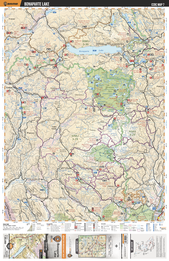
CCBC07 Bonaparte Lake - Cariboo Chilcotin Coast BC Topo
This recreation topographic map for the Bonaparte Lake area highlights all the logging roads, trails and recreational Points of Interest including hunting, camping, hiking, mountain biking, canoeing, kayaking, backcountry skiing, wildlife viewing, ATVing, snowmobiling and more. No other map provides you with this level of recreational and topographic detail for the Homathko River area. Covering the Bonaparte Lake, Bonaparte Prov Park, Porcupine Meadows Prov Park, Lac du Bois Grasslands Prov Park, Bonaparte River, Deadman River, Tranquille River, Rayleigh, Vidette, Tsintsunko Lake Prov Park and more, this map contains new features such as private land and labelled fish species. The 1:85,000 scale map covers 3,040 km2 (1,175 mi2), measuring 50 x 63.5 km (30 x 39.5 mi).
Page Size: 24 x 37 in (610 x 940 mm)
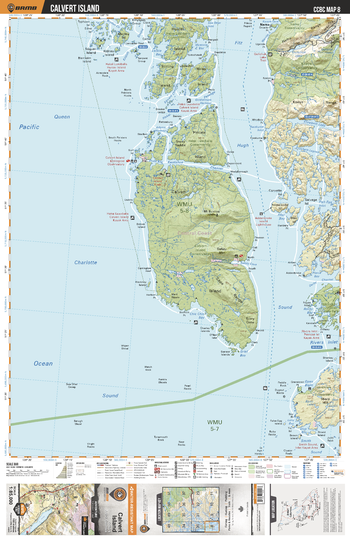
CCBC08 Calvert Island - Cariboo Chilcotin Coast BC Topo
This recreation topographic map for the Calvert Island area highlights all the logging roads, trails and recreational Points of Interest including hunting, camping, hiking, mountain biking, canoeing, kayaking, backcountry skiing, wildlife viewing, ATVing, snowmobiling and more. No other map provides you with this level of recreational and topographic detail for the Homathko River area. Covering the Calvert Island Conservancy, Hakai/Luxvbalis Conservancy, Queen Charlotte Sound and more, this map contains new features such as private land and labelled fish species. The 1:85,000 scale map covers 3,040 km2 (1,175 mi2), measuring 50 x 63.5 km (30 x 39.5 mi).
Page Size: 24 x 37 in (610 x 940 mm)
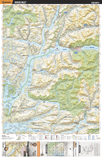
CCBC09 Rivers Inlet - Cariboo Chilcotin Coast BC Topo
This recreation topographic map for the Rivers Inlet area highlights all the logging roads, trails and recreational Points of Interest including hunting, camping, hiking, mountain biking, canoeing, kayaking, backcountry skiing, wildlife viewing, ATVing, snowmobiling and more. No other map provides you with this level of recreational and topographic detail for the Homathko River area. Covering the Owikeno Conservancy, Lockhart-Gordon Conservancy, Koeye Conservancy, Browning Channel,Darby Channel, Blackney Channel,Kilbella Bay, Wadhams, Rivers Inlet, Goose Bay, Good Hope, Dawsons Landing, Duncanby Landing and more, this map contains new features such as private land and labelled fish species. The 1:85,000 scale map covers 3,040 km2 (1,175 mi2), measuring 50 x 63.5 km (30 x 39.5 mi).
Page Size: 24 x 37 in (610 x 940 mm)
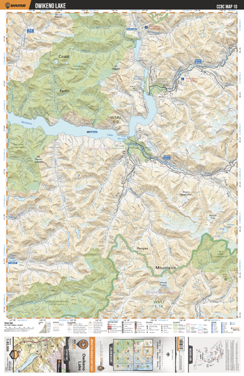
CCBC10 Owikeno Lake - Cariboo Chilcotin Coast BC Topo
This recreation topographic map for the Owikeno Lake area highlights all the logging roads, trails and recreational Points of Interest including hunting, camping, hiking, mountain biking, canoeing, kayaking, backcountry skiing, wildlife viewing, ATVing, snowmobiling and more. No other map provides you with this level of recreational and topographic detail for the Homathko River area. Covering the Owikeno Lake, Sheemahant River, Machmell River, Catto Creek Conservancy, Smokehouse Creek, Chuckwalla River, Washwash River, Marble Creek, Tzeo River, Doos Creek and more, this map contains new features such as private land and labelled fish species. The 1:85,000 scale map covers 3,040 km2 (1,175 mi2), measuring 50 x 63.5 km (30 x 39.5 mi).
Page Size: 24 x 37 in (610 x 940 mm)
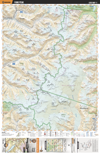
CCBC11 Fang Peak - Cariboo Chilcotin Coast BC Topo
This recreation topographic map for the Fang Peak area highlights all the logging roads, trails and recreational Points of Interest including hunting, camping, hiking, mountain biking, canoeing, kayaking, backcountry skiing, wildlife viewing, ATVing, snowmobiling and more. No other map provides you with this level of recreational and topographic detail for the Homathko River area. Covering the Fang Peak, Dzawaki/Upper Klinaklini Conservancy, North Klinaklini River, Tweedsmuir Prov Park, Silverthrone Glacier, Klinaklini Glacier, Machmell River, Catto Creek Conservancy and more, this map contains new features such as private land and labelled fish species. The 1:85,000 scale map covers 3,040 km2 (1,175 mi2), measuring 50 x 63.5 km (30 x 39.5 mi).
Page Size: 24 x 37 in (610 x 940 mm)
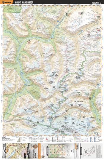
CCBC12 Mount Waddington - Cariboo Chilcotin Coast BC Topo
This recreation topographic map for the Mount Waddington area highlights all the logging roads, trails and recreational Points of Interest including hunting, camping, hiking, mountain biking, canoeing, kayaking, backcountry skiing, wildlife viewing, ATVing, snowmobiling and more. No other map provides you with this level of recreational and topographic detail for the Homathko River area. Covering the Klinaklini River, Klinaklini Lake, Perkins Peak, Colwell Lake, Charlotte Alplands Protected Area, Homathko River Tatlayoko Protected Area, Mount Waddington, Twist Lake and more, this map contains new features such as private land and labelled fish species. The 1:85,000 scale map covers 3,040 km2 (1,175 mi2), measuring 50 x 63.5 km (30 x 39.5 mi).
Page Size: 24 x 37 in (610 x 940 mm)
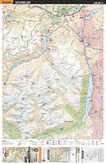
CCBC13 Tatlayoko Lake - Cariboo Chilcotin Coast BC Topo
This recreation topographic map for the Tatlayoko Lake area highlights all the logging roads, trails and recreational Points of Interest including hunting, camping, hiking, mountain biking, canoeing, kayaking, backcountry skiing, wildlife viewing, ATVing, snowmobiling and more. No other map provides you with this level of recreational and topographic detail for the Homathko River area. Covering the Tatlayoko Lake, Sapeye Lake, Horn Lake, Bluff Lake, Middle Lake, Miner Lake, Homathko River Tatlayoko Protected Area, Dumbell Lake, Eagle Lake, Tatla Lake and more, this map contains new features such as private land and labelled fish species. The 1:85,000 scale map covers 3,040 km2 (1,175 mi2), measuring 50 x 63.5 km (30 x 39.5 mi).
Page Size: 24 x 37 in (610 x 940 mm)
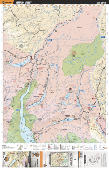
CCBC14 Nemaiah Valley - Cariboo Chilcotin Coast BC Topo
This recreation topographic map for the Nemaiah Valley area highlights all the logging roads, trails and recreational Points of Interest including hunting, camping, hiking, mountain biking, canoeing, kayaking, backcountry skiing, wildlife viewing, ATVing, snowmobiling and more. No other map provides you with this level of recreational and topographic detail for the Homathko River area. Covering the Chilko Lake, Ts'yl-Os Prov Park, Nuntsi Prov Park, Choelquoit Lake, Chilko River, Chaunigan Lake, Taseko River, Tsuniah Lake, Konni Lake, Nemaiah Valley and more, this map contains new features such as private land and labelled fish species. The 1:85,000 scale map covers 3,040 km2 (1,175 mi2), measuring 50 x 63.5 km (30 x 39.5 mi).
Page Size: 24 x 37 in (610 x 940 mm)

CCBC15 Big Creek Prov Park - Cariboo Chilcotin Coast BC Topo
This recreation topographic map for the Big Creek Prov Park area highlights all the logging roads, trails and recreational Points of Interest including hunting, camping, hiking, mountain biking, canoeing, kayaking, backcountry skiing, wildlife viewing, ATVing, snowmobiling and more. No other map provides you with this level of recreational and topographic detail for the Homathko River area. Covering the Big Creek, Fish Lake, Fletcher Lake, Scum Lake, Chilcotin River, Hanceville, Big Creek Provincial Park and more, this map contains new features such as private land and labelled fish species. The 1:85,000 scale map covers 3,040 km2 (1,175 mi2), measuring 50 x 63.5 km (30 x 39.5 mi).
Page Size: 24 x 37 in (610 x 940 mm)
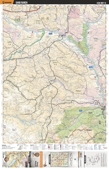
CCBC16 Gang Ranch - Cariboo Chilcotin Coast BC Topo
This recreation topographic map for the Gang Ranch area highlights all the logging roads, trails and recreational Points of Interest including hunting, camping, hiking, mountain biking, canoeing, kayaking, backcountry skiing, wildlife viewing, ATVing, snowmobiling and more. No other map provides you with this level of recreational and topographic detail for the Homathko River area. Covering the Churn Creek Protected Area, Gaspard Creek, Junction Sheep Range Prov Park, Fraser River, Gang Ranch, Chilcotin River, Big Creek, Becher House, Alkali Lake, Gaspard Lake and more, this map contains new features such as private land and labelled fish species. The 1:85,000 scale map covers 3,040 km2 (1,175 mi2), measuring 50 x 63.5 km (30 x 39.5 mi).
Page Size: 24 x 37 in (610 x 940 mm)
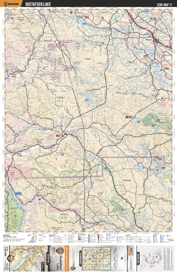
CCBC17 Gustafsen Lake - Cariboo Chilcotin Coast BC Topo
This recreation topographic map for the Gustafsen Lake area highlights all the logging roads, trails and recreational Points of Interest including hunting, camping, hiking, mountain biking, canoeing, kayaking, backcountry skiing, wildlife viewing, ATVing, snowmobiling and more. No other map provides you with this level of recreational and topographic detail for the Homathko River area. Covering the Churn Creek Protected Area, Moose Valley Prov Park, Whale Lake, Boar Lake, Helena Lake, Wright, Spring House, Alkali Lake, Chimney Lake, Fraser River and more, this map contains new features such as private land and labelled fish species. The 1:85,000 scale map covers 3,040 km2 (1,175 mi2), measuring 50 x 63.5 km (30 x 39.5 mi).
Page Size: 24 x 37 in (610 x 940 mm)
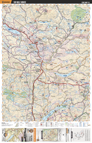
CCBC18 100 Mile House - Cariboo Chilcotin Coast BC Topo
This recreation topographic map for the 100 Mile House area highlights all the logging roads, trails and recreational Points of Interest including hunting, camping, hiking, mountain biking, canoeing, kayaking, backcountry skiing, wildlife viewing, ATVing, snowmobiling and more. No other map provides you with this level of recreational and topographic detail for the Homathko River area. Covering the 100 Mile House, Green Lake, Flat Lake Prov Park, Watch Lake, Horse Lake, 108 Mile Ranch, Lac La Hache, Ruth Lake, Schoolhouse Lake Prov Park, Lone Butte and more, this map contains new features such as private land and labelled fish species. The 1:85,000 scale map covers 3,040 km2 (1,175 mi2), measuring 50 x 63.5 km (30 x 39.5 mi).
Page Size: 24 x 37 in (610 x 940 mm)
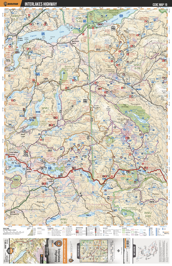
CCBC19 Interlakes Highway - Cariboo Chilcotin Coast BC Topo
This recreation topographic map for the Interlakes Highway area highlights all the logging roads, trails and recreational Points of Interest including hunting, camping, hiking, mountain biking, canoeing, kayaking, backcountry skiing, wildlife viewing, ATVing, snowmobiling and more. No other map provides you with this level of recreational and topographic detail for the Homathko River area. Covering the Canim Lake, Mahood Lake, Wells Gray Prov Park, Taweel Prov Park, Emar Lakes Prov Park, Bridge Lake, Sheridan Lake, Deka Lake, High Lakes Basin Prov Park, Emar Lakes Prov Park and more, this map contains new features such as private land and labelled fish species. The 1:85,000 scale map covers 3,040 km2 (1,175 mi2), measuring 50 x 63.5 km (30 x 39.5 mi).
Page Size: 24 x 37 in (610 x 940 mm)
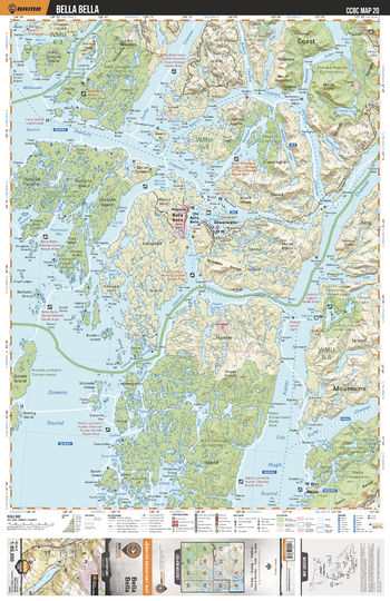
CCBC20 Bella Bella - Cariboo Chilcotin Coast BC Topo
This recreation topographic map for the Bella Bella area highlights all the logging roads, trails and recreational Points of Interest including hunting, camping, hiking, mountain biking, canoeing, kayaking, backcountry skiing, wildlife viewing, ATVing, snowmobiling and more. No other map provides you with this level of recreational and topographic detail for the Homathko River area. Covering the Outer Central Coast Islands Conservancy, Hakai/Luxvbalis Conservancy, Lady Douglas-Don Penninsula Conservancy,Spiller Channel, Seaforth Channe, Fisher Channel, Old Bella Bella, Campbell Island, Shearwater, Namu, Bella Bella and more, this map contains new features such as private land and labelled fish species. The 1:85,000 scale map covers 3,040 km2 (1,175 mi2), measuring 50 x 63.5 km (30 x 39.5 mi).
Page Size: 24 x 37 in (610 x 940 mm)