A-Z Maps
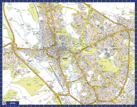
Oxford A-Z Street Map
The perfect reference map for finding your way around Oxford. This up-to-date detailed A-Z town plan includes 1,600 streets in and around Oxford. As well as the University of Oxford colleges, the other areas covered are Jericho, Cowley, Botley, Carfax, St Giles, Headington, Marston and University Parks. The large scale 1 mile to 5.5 inch street map includes the following:
• Places of interest
• Oxford cycleways and routes
Page Size: 28.5 x 22.25 in (718 x 560 mm)
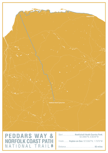
Peddars Way and Norfolk Coast Path National Trail Map Print
This map print highlights the National Trail route of the Peddars Way and Norfolk Coast Path, showing the start and finish points on an attractive relief base and created in the official National Trail colours.
Page Size: 16.75 x 23.5 in (420 x 594 mm)
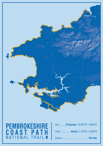
Pembrokeshire Coast Path National Trail Map Print
This map print highlights the National Trail route of the Pembrokeshire Coast Path, showing the start and finish points on an attractive relief base and created in the official National Trail colours.
Page Size: 16.75 x 23.5 in (420 x 594 mm)
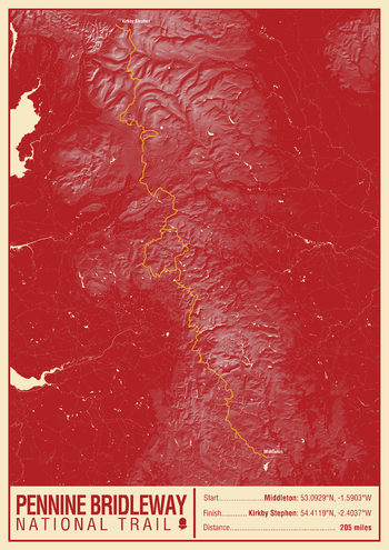
Pennine Bridleway National Trail Map Print
This map print highlights the National Trail route of the Pennine Bridleway, showing the start and finish points on an attractive relief base and created in the official National Trail colours.
Page Size: 16.75 x 23.5 in (420 x 594 mm)
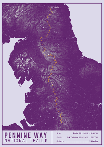
Pennine Way National Trail Map Print
This map print highlights the National Trail route of the Pennine Way, showing the start and finish points on an attractive relief base and created in the official National Trail colours.
Page Size: 16.75 x 23.5 in (420 x 594 mm)
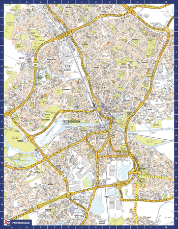
Peterborough A-Z Street Map
The perfect reference map for finding your way around Peterborough. This up-to-date detailed A-Z town plan includes more than 1,600 streets in and around Peterborough. Detailed coverage of an area extending from Walton in the north to Hampton Gardens in the south, and from Fengate in the east to Thorpe Wood Golf Course in the west. The highly detailed 1 mile to 4.5 inch street map includes places of interest, among other features.
Page Size: 22.25 x 28.5 in (560 x 718 mm)
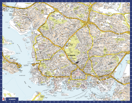
Plymouth A-Z Street Map
The perfect reference map for finding your way around Plymouth. This up-to-date detailed A-Z town plan includes more than 2,000 streets in and around Plymouth. As well as the Royal William Yard and Crownhill Fort, the other areas covered include Stoke, Efford, Pennycross, St Budeaux, King’s Tamerton, Eggbuckland and Manadon. The highly detailed 1 mile to 5.5 inch street map includes places of interest, among other features.
Page Size: 28.5 x 22.25 in (718 x 560 mm)
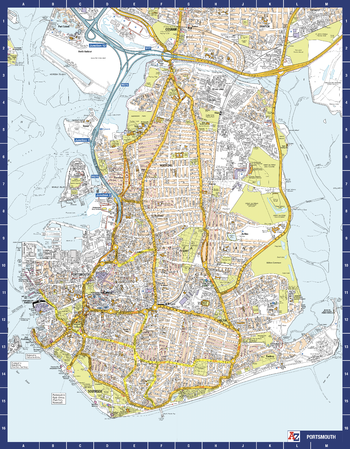
Portsmouth A-Z Street Map
The perfect reference map for finding your way around Portsmouth. This up-to-date detailed A-Z town plan includes more than 2,000 streets in and around Portsmouth. As well as ferry routes from Portsmouth Harbour, other areas covered include Southsea, Fratton, Milton Common, Hilsea and Cosham. The highly detailed 1 mile to 5.5 inch street map includes places of interest, among other features.
Page Size: 22.25 x 28.5 in (560 x 718 mm)
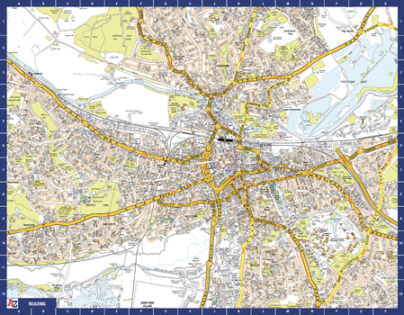
Reading A-Z Street Map
The perfect reference map for finding your way around Reading. This up-to-date detailed A-Z town plan includes more than 1,500 streets in and around Reading. As well as the city centre and the University of Reading, the other areas covered include Whitley, Coley Park, New Town and Caversham. The highly detailed 1 mile to 5.5 inch street map includes places of interest, among other features.
Page Size: 28.5 x 22.25 in (718 x 560 mm)
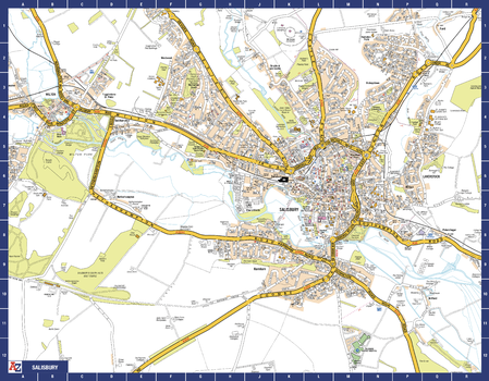
Salisbury A-Z Street Map
The perfect reference map for finding your way around Salisbury. This up-to-date detailed A-Z town plan includes more than 900 streets in and around Salisbury. Detailed coverage of an area extending from Stratford sub Castle in the north to Salisbury District Hospital in the south, and from Laverstock in the east to Wilton Park in the west. The highly detailed 1 mile to 4.5 inch street map includes places of interest, among other features.
Page Size: 28.5 x 22.25 in (718 x 560 mm)
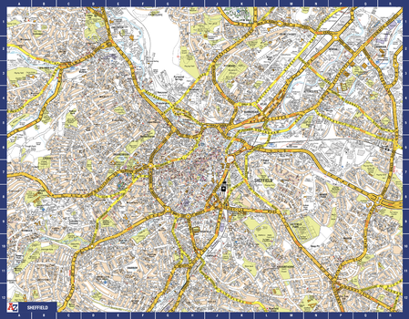
Sheffield A-Z Street Map
The perfect reference map for finding your way around Sheffield. This up-to-date detailed A-Z town plan includes 3,219 streets in and around Sheffield. As well as the central shopping area, the other areas covered are Park Hill, Burngreave, Netherthorpe, Crookesmoor, Broomfield and Highfield. The highly detailed 1 mile to 5.5 inch street map includes places of interest, among other features.
Page Size: 28.5 x 22.25 in (718 x 560 mm)
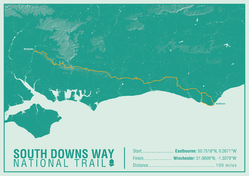
South Downs Way National Trail Map Print
This map print highlights the National Trail route of the South Downs Way, showing the start and finish points on an attractive relief base and created in the official National Trail colours.
Page Size: 23.5 x 16.75 in (594 x 420 mm)
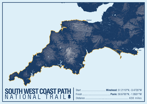
South West Coast Path National Trail Map Print
This map print highlights the National Trail route of the South West Coast Path, showing the start and finish points on an attractive relief base and created in the official National Trail colours.
Page Size: 23.5 x 16.75 in (594 x 420 mm)
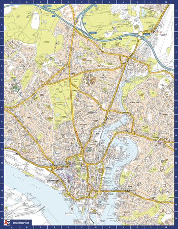
Southampton A-Z Street Map
The perfect reference map for finding your way around Southampton. This up-to-date detailed A-Z town plan includes more than 2,000 streets in and around Southampton. As well as Ocean Village and Southampton Common, the other areas covered include Woolston, Itchen, Shirley, Bitterne, Portswood, Bassett and North Stoneham. The highly detailed 1 mile to 5.5 inch street map includes places of interest, among other features.
Page Size: 22.25 x 28.5 in (560 x 718 mm)
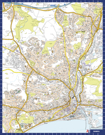
Swansea A-Z Street Map
The perfect reference map for finding your way around Swansea. This up-to-date detailed A-Z town plan includes more than 1,500 streets in and around Swansea. As well as the city centre and Swansea Maritime Quarter, the other areas covered include Brynmill, Sketty, Mayhill, Morriston and Llangyfelach. The highly detailed 1 mile to 5.5 inch street map includes places of interest, among other features.
Page Size: 22.25 x 28.5 in (560 x 718 mm)
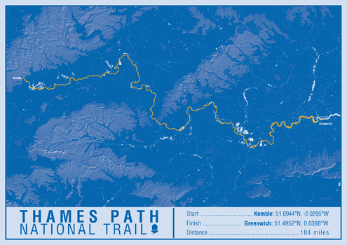
Thames Path National Trail Map Print
This map print highlights the National Trail route of the Thames Path, showing the start and finish points on an attractive relief base and created in the official National Trail colours.
Page Size: 23.5 x 16.75 in (594 x 420 mm)
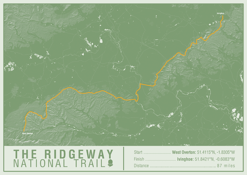
The Ridgeway National Trail Map Print
This map print highlights the National Trail route of the Ridgeway, showing the start and finish points on an attractive relief base and created in the official National Trail colours.
Page Size: 23.5 x 16.75 in (594 x 420 mm)
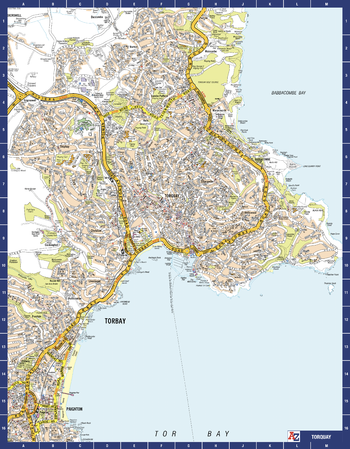
Torquay A-Z Street Map
The perfect reference map for finding your way around Torquay. This up-to-date detailed A-Z town plan includes more than 1,000 streets in and around Torquay. As well as Babbacombe and Oddicombe Beach, the other areas covered include Paignton, Preston, Hollicombe, Hele, Shiphay, Watcombe, Barton and Daccombe. The highly detailed 1 mile to 5.5 inch street map includes places of interest, among other features.
Page Size: 22.25 x 28.5 in (560 x 718 mm)
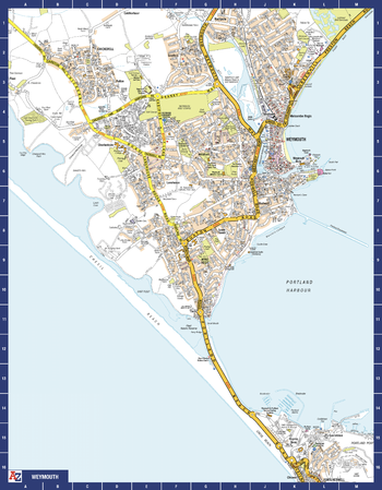
Weymouth A-Z Street Map
The perfect reference map for finding your way around Weymouth. This up-to-date detailed A-Z town plan includes more than 500 streets in and around Weymouth.
As well as Weymouth Harbour and Weymouth Beach, the other areas covered include Portland Harbour, Wyke Regis, Lane house, Rodwell, Westham, Chickerell and Southill. The highly detailed 1 mile to 5.5 inch street map includes places of interest, among other features.
Page Size: 22.25 x 28.5 in (560 x 718 mm)
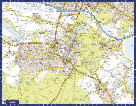
Windsor A-Z Street Map
The perfect reference map for finding your way around Windsor. This up-to-date detailed A-Z town plan includes more than 1,000 streets in and around Windsor. Detailed coverage of an area extending from Chalvey and the M4 motorway in the north to Old Windsor in the south, and from Sunnymeads in the east to Oakley Green in the west. The highly detailed 1 mile to 4.5 inch street map includes places of interest, among other features.
Page Size: 28.5 x 22.25 in (718 x 560 mm)